
After leaving Adelaide we headed north to Sydney. We were only there about 72 hours, and I haven’t exactly written a post about it yet. Partially because the weather was generally shiest. And partially because I’m backlogged on everything. Either way, eventually. Maybe?
After Sydney we hopped a 3 hours flight north to the Whitsunday Islands, which sit off the coast of mainland Australia, nestled against the Great Barrier Reef. We were staying on Hamilton Island, since it frankly seemed like the least expensive of the options we could find for this time of year. We also had gotten a small kitchenette since we saw the island had a grocery store. Though, in the end the groceries somehow would cost more than just going out and having dinner. Seriously. A 1.25L bottle of soda? $10.
In any case, we loved our time there. Here’s but a small snippet of some of the things we did. A 5 Random Things…of sorts.
1) Running to isolated beaches
One of the cool things about the island is about half of it is parkland – isolated without any homes, hotels, or other structures. Just trails to go hiking, running, or even riding on. Even better is that since initial portions of the trail leaving the main resort/town area are quite steep, it tends to deter most folks from going too far.
Early on in the week I decided to run to one of the beaches at the far end of the trail network. About as far a beach away on the trails as you could get. It would mean first climbing over the main ridge of the island, before then descending another mile or so to the beach. The trail alternated between being fairly dense woods, along with random moments of clearings like this:

The woods were nice though, as they provided shade from the sun. It was already about 85°F (30°C) and probably 90% humidity….at 8AM. I’m not exactly a hot weather runner.
I only saw two people on the trails that morning on the way out, which is perfect in my mind. Eventually I’d arrive at the beach:

It was perhaps 100m long or so, and nicely white sand. Even better is that if you wanted to lounge away the day at it, there was still a bit of shade under some trees near the edge of the forest.
In my case though – I was just using it as my turnaround point. After taking these photos (in case you were wondering, I used the GoPro 3-Way Pole attached to some dead trees), I headed on back across the island. The only part that sucked? Having to climb back up the ridge line again.
Still, I’d be happy to run out on these trails every day. Now I just gotta find myself a tropical island to buy. I mean, a really cheap one.
2) The Great Barrier Reef
Mid-way through the week we decided to let The Peanut have a day at the spa by herself. And by the ‘spa’, I mean the ball pit at the Clownfish Club, which is the little daycare at the hotel. This would actually be the very first time she’s gone to a daycare, though, she starts French daycare next week. So consider it a tropical primer.
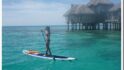
Meanwhile, The Girl and I jumped on a high-speed boat for two hours off to the Great Barrier Reef. One couldn’t go all this way to Australia and this region specifically only to skip the reef!

Of course, we knew going into it that this would be a somewhat touristy proposition. But it was the most ‘reasonable’ option we had (chartering a helicopter wasn’t in the cards). Essentially, the tour takes you out to a pontoon that’s permanently moored out on the reef itself. You’ve got about 3-4 hours out there to do as you please, including snorkeling or semi-submersible boat rides, or even helicopter rides.
For us though, it was just snorkeling:

Underwater we played a bit with the Nikon Key Mission 360° action cam, with The Girl getting some shots here and there with it.

In between snorkeling sessions, I did an openwater swim around the buoy area. They keep you in this specific area, mostly to keep random tourists from floating off to sea.

Still, the perimeter was about 1,000m long, so not too bad! Regrettably, I didn’t take a reference GPS with me on my swim buoy, and relied upon the Apple Watch Series 2 GPS. That made a beautiful track, but alas, you can’t overlay that track on the satellite view, nor can you export it to anything else. All I can show you is this stupid JPEG image. Super disappointed.

#GPSProblems aside, we had a good time out there. Certainly, with both of us being certified divers, we’d loved to have been on a liveaboard boat and spent some time diving around less touristy areas. But with The Peanut on this trip, that wouldn’t really be realistic.
One interesting thing they offered is the ability to spend the night out there on the pontoon. Thus you get all the time in the morning before the tourists arrive (around 11:30AM), and then all the time after they leave (around 3:00PM). Just a handful of people. That’d be super cool! Maybe on another trip some day.
3) Openwater Swims: Animals want to kill me
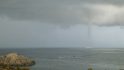
I got in a pile of openwater swims while on the island – as well as on (above?) the Great Barrier Reef itself. On my first swim on the island, I didn’t really see much in the way of sea life. The tides at the time I swam were such that it stirred up a fair bit of the water, making it a bit limited in visibility.
However later in the week I did better with animals. Even if I think some of them were out to get me. This last swim I did at super low tide, albeit not on purpose. To compare the differences in tides, here’s two drone shots – taken about an hour away from both low and high tides. So the water got even further out on low tide:


This meant that I had to walk quite some way to even get to the water’s edge. Once I did, I stood there in about ankle deep water and got all my watches and junk ready to go. A few GPS watches, the swim buoy, packing in some flip-flops for the walk back, etc… This process took about 3-4 minutes. Upon finishing I looked down to make my first step – and sure enough there had been a nice sized sting ray there the entire time less than a foot away. Had I not looked down, I would have easily stepped directly on it again. Last time that didn’t end well at all for me.
I couldn’t quite get a picture of him, as when I tried to – he swam away. But I spotted him or his friend a few minutes later – so here ya go:

The first part of the swim was slow going, since the water was only perhaps 2 feet deep (at most), so my stroke was a little wonky. Eventually though I got out far enough to get into deeper water, where I managed to see a turtle. I’ve seen a fair number of sea turtles over the years, and this was by far the largest one I’ve ever seen (though as always, pics make it look smaller).

This was my setup by the way – this specific photo was taken a few days earlier on a higher tide day.

A short bit after the turtle it was back into the shallow water for some time, and more slowness. My goal was to basically swim down the beach one-way, and then walk back. But eventually I simply ran out of water when even my chest was hitting the ground. So it’s here I stood up…only to find a small shark circling me. I got a picture of it swimming away; you can see the black-tip fin almost waving bye bye.

Of course, a tiny shark like this doesn’t much bother me. Had I seen Great Whites again…I might have had second thoughts.
From there I made the longish walk back to my starting point. It wasn’t a fast swim of course – given I wasn’t getting much extension on my stroke, but it was at least a swim. So that counts for something.
4) Beautiful beaches
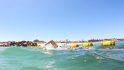
On our second to last day, we took a small half-day trip to nearby Whitehaven Beach, a short 25-30 minute boat ride away. Of course, we brought The Peanut with us – since she loves hanging out in the water. For this trip, we just did the half-day, since any more would have been a lot of time on a hot desolate beach with the little one.
In taking the early morning boat (it met up at 7:45AM), we got ahead of the crowds and had the majority of the beach to ourselves.

Or, in The Girl’s case, the majority of the water to herself. Well, her and her floating doughnut. No really, it’s actually a doughnut – complete with a bite out of it.

All of the pics here were taken with the DJI Mavic drone. This was really the perfect sort of trip for it. It easily fit into my backpack along with towels and other stuff. And it was quick and simple to deploy. The only downside being the low-profile is a bit trickier on the super-fine sand. So I had to launch it closer to the water’s edge than I’d liked to, simply to find harder sand.
What’s impressive though is just the image quality you get out of it. I shoot dual RAW/JPEG from it, and here’s the original (actually, it’s slightly cropped to 4:3):

But then here’s the crop of that same photo – the resolution is still amazing. You can now clearly see the doughnut’s missing chunk on the left side.

I didn’t actually take much video, just a bunch of photos:

I knew that I’d likely never end up editing a video cut – and honestly, with only about 2.5 hours on the beach – we didn’t have a ton of time to get footage. I was instead enjoying spending that time with The Peanut and The Girl.
5) Running to the peak
On our last morning on the island, The Girl and I went off on our respective runs. She took the little one in the stroller out on the (not-so-flat) roadways, while I went back into the trails for one last trail run. This time I’d be headed back up to the top peak, appropriately called Passage Peak. The Girl and I had hiked it earlier in the week, but this time I was going to do it as a run.

The trail itself ascends pretty darn quickly, with very little foolin’ around. I think they did that as a deterrent to random unfit tourists or something. Scare them off the trails with an 11% starting incline. Not sure. Either way, even my 5-7 minute warm-up didn’t mean much at that point.
It only took me about 22 minutes to climb to the top, which isn’t too shabby for the vertical, or the distance, and being trails. I forgot to get a pic immediately upon reaching the top – but I did take this right before heading back down.

Once atop I pulled out the DJI Mavic drone to get a couple of quick pics. I had stashed it in the GoPro Seeker backpack, which I’ve used for most of my trail running/hiking adventures as of late, as well as cycling where I want to take gear with me. Despite being overpriced, it works great for that.
A minute or two later the drone was unfolded and up in the air, snapping a couple of quick shots of me:

About 3-4 minutes later I had it back down on the ground and ready to run down the hill. We still had to pack up the hotel room disaster (seriously, how did it explode like it did?), and get ready to head out. Thus I had to keep things under an hour all-in.

Still, can’t go wrong for one last quick trail run!
Randomness:

Finally – some of you might ask whether we’d go back again to Hamilton Island?
Yes and no.
I’d have no issue recommending the place to others, as we rather enjoyed our time on the island. But I don’t think we’d go back again to this specific island. And the reason is simple: The groceries were too expensive.
Part of our reasoning for choosing this location over others we evaluated was that we could balance out the higher cost of staying on a small island (and the benefits that come with that), with buying groceries and cooking our own lunch/dinner each day (breakfast was included). But when it somehow would cost *more* to buy groceries for dinner each night than just go out for food, it became kinda a silly waste of time and money. Especially since we weren’t cooking anything fancy. A simple protein and a side of vegetables.
My bet is if you had a bigger group you could probably gain economies of scale, but with only two of us eating adult food, it just wasn’t scalable.
One thing to understand about Hamilton Island is that it has numerous resorts and private residences on it, along with a main street and shops and stuff. Yet it’s kinda like Disney World: At the end of the day, everything is basically owned by a single enterprise. So while the grocery store was independently owned, it was clear that they had to pay Hamilton Island Enterprises a substantial amount of money based on certain sales factors. Their ‘all out of bread’ sign one day indicated exactly as such.
Still – don’t get me wrong. The island is stunningly beautiful, and the opportunities for running, riding (mountain bike), and swimming (openwater), are amazing. And we were able to find a healthy blend of doing daily outdoor sports, yet still enjoying lounging by the pool or in the ocean right at our doorstep. And the fact that no cars are on the island is great (only golf carts).
My only point is that judge your locale based on the various amenities that you want, and not so much based on whether or not you can save money on groceries. And I should point out that the food we got at restaurants in town was generally quite good, and the prices for the main courses generally in-line with the prices we’d pay at home in Paris (though appetizers and drinks were crazy expensive).
With that – thanks for reading!
—-
Just in case folks are wondering what gear I used. Here’s the rundown:
A) Drone shots: DJI Mavic (all these shots if you hover over them start with DJI****)
B) Underwater/in-water shots: GoPro Hero5 Black (all these shots start with GO****)
C) Running shots: GoPro Hero5 Black (also start with GO***)
D) Misc shots around the island Part 1: iPhone 6 (start with a date stamp)
E) Misc shots around island Part 2: Nikon D500 DX DSLR (starts with DSC_)
I had the Garmin VIRB Ultra 30 with me, but for beach destinations I prefer the waterproofing of the GoPro Hero5 Black. I’d use the VIRB Ultra a fair bit more the following few days in Melbourne. I also had the GoPro Hero5 Session with me, though I was dual shooting it and the GoPro Hero5 Black on a dual-rig, but purely from an editing workflow standpoint I only used GoPro Hero5 Black photos in this post.
All my photography gear can be found here in my recently updated post!
Enjoy!
FOUND THIS POST USEFUL? SUPPORT THE SITE!
Hopefully, you found this post useful. The website is really a labor of love, so please consider becoming a DC RAINMAKER Supporter. This gets you an ad-free experience, and access to our (mostly) bi-monthly behind-the-scenes video series of “Shed Talkin’”.
Support DCRainMaker - Shop on Amazon
Otherwise, perhaps consider using the below link if shopping on Amazon. As an Amazon Associate, I earn from qualifying purchases. It doesn’t cost you anything extra, but your purchases help support this website a lot. It could simply be buying toilet paper, or this pizza oven we use and love.


Good effort on Peaks Passage :D really nice article, thanks for sharing with us
I see you’re wearing the Suunto Spartan Ultra again… Does it mean all hope isn’t last for the watch? Is it better now? I’m curious about an update; I’ve not decided yet if I want the Suunto (love the looks) or one of the upcoming Fenix 5… But to be honest, if I was on holiday there, I wouldn’t write a lot :-).
Regards,
Martin
Just wearing it to see how the latest software update for GPS accuracy (and data field conf) handles. Looking to amend my existing review in the coming weeks, based on last week’s update. At present though, I’m not really seeing anything earth shattering.
Oh, that looks like a blacktip reef shark. Super friendly guys, and as dangerous as a puppy. As long as you don’t wade through the water (they rarely give you a little, mostly harmless bite then).
…says as I wade through the water back to shore…
I used to work on Hamilton Island and lived on the island for a year. Staff and residents actually order groceries from the mainland that come over on the barge (not really feasible for tourists though). As you say, everything on the island is subject to the ‘island tax’ and hideously expensive.
It’s a stunning part of the world though. For anyone interested it’s also possible to stay on the mainland at Airlie Beach where there are lots of accommodation options from backpackers through to 4 bedroom houses. Food is also cheaper there and it’s still possible to do day trips out to the islands and reef.
Glad you guys all enjoyed yourself though.
Great read, looks like a lovely trip. If you have a minute, could you share some pics of your loadout with the seeker bag? I’m trying to find a decent bag that I can stuff my mavic, Hero5, and a mirrorless camera into – hopefully with a little bit of room for extra junk.
Yeah, I’m bummed – I actually took a few pics at the top of the mountain with all the gear laid out (from the Seeker). Yet for some reason I can’t figure out where the heck those pics went. Really weird.
That said, with the Seeker bag, I can fit:
A) Mavic with 3 batteries (one attached), controller
B) 3-5 GoPro Hero5 cameras (a few more if I get creative)
C) My DSLR
D) Wireless microphone set
E) Tripod attached to side (both the 3-way as well as a full-on tripod, one each side)
F) And a few other random things stuffed in there – like snacks and such.
G) Hydration bladder (CamelBak) inside
That’s actually the full list of gear I stuffed in my bag during some of the Mavic Review filming that I did on the Canary Islands.
Nice, sounds like it’d be about perfect then. It looks so small on the shelf at the store, never thought it would hold that much.
Zooming in just to check the resolution and quality of the pics ?! Yeh right.. we believe you! ;)
This looks GORGEOUS
Hi Ray,
Did you need some sort of authorization to fly the drone on Hamilton Island?
Just asking because there is an airport on the island with, I am assuming, strict regulations around drones?
It’s actually interesting, I did a crapton of regulation digging about it before flying. I spent hours reading up on everything I could find. It’s nuts. Australia is kinda a mess when it comes to regulations. They aren’t overly bad, but just they overlap from different agencies. Each territory has it’s own, and then each parkland has it’s own, and then there’s the federal ones. Finally, private property owners can attempt to put regulations in place, but Australian courts have ruled those have no legal basis/standing. So that’s more of a ‘ahh…cute’ type of thing. In any case…
The airport of course being the most prudent one. The Australian regulations (CASA/CASR*) note that in general if you’re flying within a few kilometers of an airport, you should ensure you’re nowhere near the flight paths. In my case, that’s easy since there’s only one runway and take-offs/landings go one way (otherwise they hit the mountain), and I stayed on the other half of the island. Next, there’s a max height limit – also easy, as I rarely have any reason to go about 120m. So I hard-set my Mavic limits to 110m (which they normally are anyway). Finally, there’s the distance limits, which I set as well.
Of course, the DJI app also has restrictions within it. Two in fact for Hamilton Island airport, with differing max elevations. Where I flew (on the beach and on the peak) are outside of the restriction zones for the airport. Though for example, had I wanted to fly at that deserted beach I ran to, that’d have been roughly on the flight path and a bad idea.
*https://www.casa.gov.au/modelaircraft
Oh – and as a side note, these same regulations are actually why I didn’t fly on the Great Barrier reef (I had brought it with me). Specifically that they were doing helicopter operations (four helicopters on 10 minute circuits), right next to the pontoon. So far too dangerous. Had we stayed overnight there, then it would have been great.
Though technically one could argue the ‘within 30m of a boat’ rule, but that rule also states that if they’re ‘involved’, then it’s OK. Kinda a weird rule, but usually interpreted as long as you’ve got the OK from the boat owner, you’re fine.
I did actually check on the Great Barrier reef park stuff, and in short – it’s interestingly allowed out there as long as you’re not bothering wildlife (specifically birds). Given the helicopters were stirring up about 300 sitting birds on their helicopter pad every 2 minutes… I think I’d have been OK. ;)
Hamilton Island has a control tower and therefore is a no fly zone for 5.5km around the aerodrome. I have written an article to try and demystify drone usage in Australia and can be found at: link to unsealed4x4.com.au
The Whitsunday Islands are a great place to hang out and explore. There are lots of different options for camping/kayaking which allows to you enjoy the islands without crowds and a ferry service to drop you to different islands campsites that you can book all to yourself. Check out the Qld National Parks.
Interestingly, the CASA site seems to differ there. It doesn’t differentiate between controlled and uncontrolled space within the main page.
G’day Ray,
Yep, even the CASA website is confusing basically giving you two sets of rules for recreational flying.
Because you put your footage up on a ‘commercial’ website, flying the mavic would then come under commercial regulations for under 2kg link to casa.gov.au
Drones in Australia are currently causing a lot of headaches with all sorts of people and Govt departments and confusion still reigns for the most part. Great blog by the way!
Coles supermarkets allow you to order groceries online and then ship your food over to Hamilton Island on the barge. That should be a lot cheaper than being held hostage by the shop on the Island.
Very impressive run up Passage Peak and back, especially given the heat and humidity. Seriously the Australian summer (December, January, February) is the worst time of the year to go to Hamilton Island. At this time of the year Lord Howe Island in NSW is a lot more pleasant, and the groceries are cheaper! It is, however, worth going to Hamilton Island in November for the annual triathlon. This is tough for a sprint distance race with a truly spectacular course.
Ray great post.
A tip for next time you can put in a Coles order online to be delivered on the day you arrive – that’s just a regular grocery store so the prices are normal. There might be a delivery fee but it’s much better than the store there which is really just for an item or two!
you hit all the things we did when we lived in Sydney, including the reef sharks. We too went to Hamilton with some friends, and had a hard time getting over the prices. That said, had a great time at Whitehaven and other spots, and like you probably won’t go back. That’s the one bummer about living in Oz – it’s often cheaper to go to other countries on holiday compared to going up the coast a bit! Hope you had a nice time overall.
Ray
The Mavic image quality is quite good; apart from the ease of flying it, do the images match the Hero 5?
Thanks,
Generally I think so. There’s always endless debate about it on forums – sorta like Canon vs Nikon. In one edge case one might have better quality vs the other, etc…
Hi Ray, did you see the new Super League Triathlon’s first event will be held on Hamilton Island in 2017? Having just been there yourself, I’m curious to hear your thoughts on the new League and the choice of location for the first event? Have you ever done any of the formats? It sounds intense but fun!
Assume the groceries comment is out of date, and assuming the IGA wasn’t open then and it was a smaller store maybe? As a bottle is Coke is $2-3, not $10. Big bag of Doritos for $3 (well $1.50 this week as half price)
The IGA looks pretty new, so assume it is and probably after this post, and as such that bit is probably now a bit out of date.
Looks like according to their site it just recently opened. Indeed, there was no IGA then. Sounds like the prices are quite reasonable – which is great!
We’d never consider coming back otherwise, since the prices were simply too outrageous. Awesome!
The IGA opened in July…