After touring our way down the western coast of France, I arrived Thursday night into the Pyrenees region along the south of France – ready to begin three days of riding. Much of what I was doing was aimed at testing out various units for reviews coming up this week, with a particular focus on altitude testing (how accurately a device reports elevation).
Day 1: The Famous Col du Tourmalet
I figured for my first day I’d simply aim one of the most well known climbs in the Pyrenees. It’s been featured in Le Tour a total of 82 times to date, and will again be in the route this year in Stage 18, on one of the final days of the tour.
I was staying down in Campan and so after about 5K of gentle ascending I hit the turnoff town and started the main marked portion of the climb.

Like many climbs in France, this was well marked with signs indicating your current altitude (1215m), the finish altitude (2115m), how many kilometers were left (10KM), and then the average grade for the next kilometer (8.5% in this case).

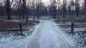
Now, as you can see the weather was generally crap. Rain, wind, and simply cold. And for the most part, the lower portion of the climb looked like the above photo. It wasn’t until I finally broke out of the forested area that things started to change view-wise. I’m sure on any other day the view would have been epic all the way up. But for me, I was basically just riding in the fog and trees.
Below, a slight change of scenery as I pass through the base of the ski area.

Once I got through the base of the ski area, things sorta opened up, as I was in between two layers of clouds. The summit is up ahead in the clouds.

The road twists and turns through the snow banks on a small road leading up to the roadway summit (the actual summit is a bit higher and is served by a ski lift).

You can see the route ahead of me for the final 2KM as it swings back and forth under the chair lift. Off to the far left is the actual peak.

I believe that the below switchback was probably the worst of the turns of the entire route. It was already in the 9-10% range when it made this tight little twist upwards briefly spiking the grade.

Here’s a look back down to the base of the ski resort (right about where the clouds start again).

Upon reaching the top there’s a small restaurant/bar that was closed, as well as a sign indicating the top altitude – 2,115m (6,939ft). There’s also normally a big cycling statue there too, but it’s removed for the winter. I actually saw it down in the town near where I was staying. My understanding is that it’s installed next weekend.

The route actually continues over the pass down the other side, but the road was closed still. You can see the route below. There were some cyclists heading down – but given that was a bit of an unknown for me (and I was just by myself), and I was already freezing, I decided against it.

Instead, I slowly descended back down to the ski area. With the roads wet (since it was alternating between light rain and pouring), as well as the steep grade – it was slow going. I’m all for descending very quickly on roads I understand and know well (50MPH during Ironman Canada), I’m not so good at it on wet roads I don’t know well that drop off hundreds or thousands of feet.
I stopped in the village to grab a bite to eat (actually, I was just miserably cold descending and wanted to warm-up and feel my fingers again for the bulk of the descent).

I sorta did lunch backwards. I started with a crepe, then moved to hot chocolate, then the steak frites, and finally more hot chocolate (the Mickey Mouse bottle was provided for water). As you can see above, the place was packed with cyclists doing the same.

Post-lunch I continued my way back down to my starting town (where I’d buy gloves and a rain jacket). I don’t usually ride with gloves (a lot of triathletes tend not too), and I was perfectly warm going up, but once you head down without any work effort for 30-40 minutes, things get cold quick.
Still, gloves or no gloves – if you’re in the region definitely hit up the Tourmalet, and even though the weather wasn’t so epic, the climb certainly was. Here’s the overall profile of my ride (the little elevation blip coming down was riding the few hundred meters to the food place):

The above was created using Mesmeride from my Strava file.
Day 2: Col d’Aspin served up…twice.
Now that I had the hang of things, I was ready to go a bit further the next day. Of course, it was still raining. Actually, the weather was slightly worse this day than the previous – despite what appears to be a brief sun spot on the road. That was the last I saw of it for many hours.
I headed back out from my hotel and started working my way along the valley floor towards Col d’Aspin. While it certainly wasn’t flat – it was in only about 3-6%, so it’s a nice warm-up.

Well, at least until I ran into some cows.

The farms in this area use the roads as a way to move herds. And in this case, said road would be my route. It was entertaining though. Passing them was a bit tricky, because the cows had little care/respect for a cyclist (they barely cared about cars either).

But eventually I found an opening and nudged my way through.

Shortly after I passed the cows the road turned upwards and the real climbing started (those 8-10% grades). It was here on a small hill that folks were practicing parasailing.

Now I’m not an expert on parasailing training. However, if I was selecting a locale to jump into the air for the first time with limited/questionable experience in control of said aeronautical device, I’m not sure I’d select this one.
This is primarily because my landing choices would be dependent on precisely where Bessy the cow (and her friends) were munching at any point in time (no fences). Assuming I missed Bessy though, I’d still have plenty of options for failure. For example, there’s the snow-fed river, or the power lines ringing the entire property. Alternatively, I could go on-piste and hit the Poma ski lift or the restaurants with watching patrons. And should all those not be appropriate there’s still the line-up of parked cars or the moving ones on the road itself.

No worries, I’m sure it always works out. It always does, right?
After leaving the scene behind I climbed up into the forest. Bessy was here too.

The route is covered with hand-written notes for various Tour de France riders. Oh, and yes, more Bessy up ahead on the turn. Three of them hanging out on the road to swerve around.

This particular climb isn’t terribly scenic on this side. Or rather, again, due to the fog it wasn’t for me.
I reached the top the first time, and this is what I found as I prepared to descend again:

I oscillated between being happy and sad that I couldn’t see over the edge as I began my descent. Visibility was quite limited.

Unfortunately, I have approximately zero photos from the descent. Mostly because I don’t typically take photos while descending. But also because there wasn’t much to see. Fog, lots of it.
Eventually though I got down to the bottom and below the fog/clouds to a small town, which would serve as my turnaround point.

From there, I started back up near immediately – only to ascend the same Col again. Doing it once was clearly not enough.

This time the fog parted a tiny bit, and I was able to get a few photos while going up. Below looking back, you can just barely see the town way far away down there. The roads you see are largely ones I’d ridden up.

Finally, the top (again)! I did meet a few other rather nice cyclists here. Though, I mostly had to explain why exactly I had 9 GPS devices (barometric/GPS altimeter testing for an upcoming post). I justified that it was simply too easy climbing these passes with just my own body/bike weight, so I’d add a bunch of extra metallic weight ‘just cuz’. They seemed to buy it.

From there me and my rain jacket and non-cycling gloves zipped back down to town. I passed the paragliders again, nobody seemed to be strung up in the power lines yet. Unclear though if anyone had been lost in the raging river, the evidence would have been long gone.
Once I hit this building, I was almost home – just 5K to go! This building is in a town where you choose which of a multitude of climbs you’ll be doing.

Then, just as I hit the town limits for my town, the sun broke out. Seriously.

Oh, and more sun as I put my bike away at my 48€ per night hotel (including breakfast!). The married couple that runs it only have three rooms, but they’re nice and clean (and big!). And while they speak not a word of English, they were unfailingly helpful and friendly. Absolutely the perfect ‘basecamp’ option for climbing in this area.

Here’s what all that fun looked like, heights are in meters of course, distance along the bottom in kilometers:

Like the first image, this too was done using Mesmeride from my Strava file.
Day 3: Climbing up to high alpine lakes
For my last trick, I’d drive about 45 minutes away to start my last climb. I did this because I was simply super-tight on time before beginning my 8-9 hour drive back home to Paris. Otherwise, you could actually do all this in one (very long) day trip from Campan.
Unlike my previous climbs, this route was much quieter and much less trafficked. Also, since I parked directly at the turn-off for the route, there was no warm-up, it was straight into 8% grades (and then it got worse).

Oh…here’s worse – a nice fun 11%:

It’s funny, after a while anything 8% and below was ‘perfectly fine’. 8.5% was ‘so-so’, and 9% was ‘less than ideal’. But once I hit about 9.5-10%, things started to hurt a bit more. Even on my compact crankset I was well past out of gears, thus my cadence dropped a fair bit.
In general, I was fairly content with my actual wattages on most of these climbs, especially for three solid days of cycling less than a week after finishing a marathon.
As I climbed, a river near the road was oscillating between quiet/peaceful and roaring. They had signs explaining not to go swimming. Quite frankly, given how cold that water is – I have no idea why you’d want to do that anyway.

The road here was definitely not designed for speed. If you look carefully, you can see it twisting back and forth in switchbacks up this mountain face (look for the flat retaining wall sections).

I sorta-appreciated that they put little barriers in a half-hearted attempt to keep cars from going over the edge. At the same time, I realized they’d do absolutely zero good for a cyclist.

As you get closer to the summit you’ve got two different climbs/destinations you can choose. Both end in lakes and dams. I initially went up to the left for a few hundred meters, but then turned back down and went to the right instead.

It was here that I reached what would be my final destination. While I had planned and wanted to go all the way up to the dam seen in the background, I was simply running out of time and I wasn’t quite sure how much longer it’d take me.

Ironically I had actually mapped out a route for doing both climbs and transferred it to my Garmin. But that was done the previous night post-pizza when I was apparently feeling more optimistic about my climbing speed. I had neglected to account for the 10% grades being substantially slower than the 8.5% grades. Still, not too shabby a place to end my weekend! Here’s the Strava file.

From there I zipped back down to the town I started in, where I grabbed my beast of a minivan rental. Our second one actually, the first one died in Bordeaux of a flat tire and had to be swapped out by Hertz. After that it was a 9hr drive back to Paris (lots of traffic).

Hopefully I’ll be able to get back to the mountains sometime this summer – love the climbing options and how easy it is to do multiple climbs from the same base area. Oh, and all the routes I found were from this site. Definitely the ‘go-to’ resource for anyone wanting to do any of the climbs in Europe.
Thanks for reading!
FOUND THIS POST USEFUL? SUPPORT THE SITE!
Hopefully, you found this post useful. The website is really a labor of love, so please consider becoming a DC RAINMAKER Supporter. This gets you an ad-free experience, and access to our (mostly) bi-monthly behind-the-scenes video series of “Shed Talkin’”.
Support DCRainMaker - Shop on Amazon
Otherwise, perhaps consider using the below link if shopping on Amazon. As an Amazon Associate, I earn from qualifying purchases. It doesn’t cost you anything extra, but your purchases help support this website a lot. It could simply be buying toilet paper, or this pizza oven we use and love.


Bonjour je connais ce périble, je l’ai fait dans l’autre sens ASPIN – TOURMALET et en VTT, les gens m’ont pris pour un fou LOL, mais très bon souvenir
——————————————————————————————————————————————-
Good morning I know this périble, I made it in the other sense ASPIN – TOURMALET and in VTT, people took me for MADMAN LOL, but very good memory
I’ve often wanted to try a couple of the famous climbs. I’m not sure if I’d be too scared to do the coming back down!
Thanks Ray – excellent report. I was there last september and did both Tourmalet, Aspin and other cols. Weather was better .
Looks like a great way to spend the weekend. Enjoying climbing with Di2? Couldn’t imagine doing that on a TT bike otherwise.
Honestly, for these climbs I rarely got to use the Di2. It’s more or less set it and forget it (easiest gear), with a few minor fluctuations changing grade, but instead I generally just changed cadence.
It’s actually kinda funny, the Edge 1000 will show in your ride summary how many front shifts and rear shifts. For the first day, I had four front shifts (in three hours). And one of those was just to simply ‘wake up’ the system.
Just magical cycling and super pictures :-)
I was in The Pyrenées last summer and it was a blast (late July-early August). Super hot though, 42 deg Celsius when climbing a 11 % gradient in the sun is.. challenging :-)
I think it takes courage to descend on a TT bike. Glad you take it slowly!
Looking forward to more posts like this!
Excellent Monday morning reading! Thanks. DCR and a few newspapers have become my go-to morning reading now — work is just gets delayed a little bit more…
Smart to take the descents easy in unknown territory (slick or non-slick roads) — were you able to use any livetracking or no coverage?
I probably could have used Live Tracking, but alas, the Edge 1000’s Bluetooth Connection drops too much.
Ray – Nice work on those big climbs! Was it tricky going up and down on a tri bike?
No problems going up. Going down was tricky, but not so much because of the tri bike – rather, just because it was wet and steep. On the 3rd day without the rain, I was able to descend a fair bit faster (safely).
Absolutely amazing post and pictures. I makes me want to go there RIGHT NOW. Cervelo should hire you as a photographer, you sure know how to showcase their gear in picture perfect settings. Beautiful, just beautiful. May I ask to use one of your pictures on my blog/FB? The one with the single cow on the side of the road. I love cows and I love biking, so I’m sure it’ll keep me smiling for a while. Thanks Ray!
Thanks Irina!
Yup, feel free to use the cow pic. :)
How in the world can you take photos of your Garmin Edge at a 11% gradient, pedaling at 300W without falling off? :D Did you use the Garmin Actioncam?
Hey Ray … Why don’t you come up to see the L’Etape du Tour this year ?? me and 9 buddies are coming from Brazil, and it’s gonna be a looooong and very nice day …
your review of the Tourmalet really gave me some hope of finishing it ;-) !! ….
How was descending of these mountains with carbon wheels ?? with the water + carbon wheel breaking ?????
A quick elevation question I’ve been meaning to ask, although I suspect you may be planning to put it in your elevation write-up. If so, apologies for jumping in too early. I know that Garmin Connect’s elevation correction trumps non-barometric altimeters, like the good ‘ol FR305. But what about devices with barometric altimeters (like the Edge 500)? Do you still use elevation correction? Or do you trust the altimeter more in those instances?
Thanks!
In general I go with the data from the altimeter over the corrected data (for devices that support it). This weekend was a good example, where Garmin Connect was automatically enabling it for the Fenix2 (I’ve asked why, and am awaiting clarification). In that case, the online corrected version was some 400m off (total vertical gain), whereas the native device captured data was within a couple meters of everyone else (really impressive)
Not sure if it’s just me, but been having problems turning corrected data on/off for both the Fenix2 and Edge800. Can click on it, but nothing happens.
Great report, fantastic pics as always. Recently moved to southern California from Colorado, so I’ve been learning about steep (albeit relatively short) climbs. My last bump Sunday was 8%-9%, with a 17% kicker at the top. You’re spot on: After a while 8%-10% feels doable, at least compared to the really steep stuff.
As for your meal at “the food place” (I believe the French word for it is “restaurant”), someone once said, “Life is uncertain. Eat dessert first.” Words to live by, mon ami.
Glad your trip went well.
I love the cow photos. Lac Cap de Long and the Route des Lacs is probably my favourite climb in the Pyrénées. Quiet, challenging and beautiful.
a+
I think I just noticed a Rotor Power crank mounted on your bike? Just curious that if it performed flawlessly on your bike? Mine has some issue with battery contact; sometimes the unit cannot be started until manual battery reset is performed. One of my friend has similar issue too in his left crank arm, don’t know if this is common in Rotor Power.
Ironically, this weekend was the very first time I had issues with not waking up and the unit. I ended up having to pull batteries. I subsequently updated the firmware which just came out last week, and have been fine. My batteries were also a bit on the low side, I could write it off to that (just ordered new batteries).
Beyond that, I continue to have issues with it improperly measuring (slightly high) my right side. It’s kinda complex to explain, but in short, I’ve been able to determine through a lot of testing with many PM’s at once that right side measurement is about 5-8% high (not my right leg, but the measurement of it).
Thank you for the beautiful post and looking forward to the upcoming reviews.
great update – and I do love the Pyrenees – had some fun (if not slightly scary) times cycle touring through them on a tandem in the mid 90s!
Ray,
#1: Going down Tourmalet vers Luz Saint Sauveur means you have to do a miniun 100km tour (best one through Juncalas and then down to Bagneres de Bigorre) It is tricky to find your way if you follow this option, so you better have it on your GPS, in case you happen to have one :-) The tour is an amazing 4 hour ride. If you go for the easy Luz-Saint-Sauver/Lourdes/Bagneres de Bigorre, slightly longer and much more noisy trafic. In case you come down back, ask for help on gps tracks. Luz Ardiden and Aubisque are a must. Luz Ardiden because is part of the legend and Aubisque for its scenic road plus part of the legend as well. Argeles-Gazost is probably the best option for the basecamp within the Western part of the Pyrenees.
#The sign is not for swimmers, but for other folks that might be wandering around the river (like fishermen) and the danger is that they might be carried away all of a sudden because the damp opens up above sending enourmous amounts of water. You probably also saw many works near the rivers because of the 2013 big flood. The region was literally devastated (and parts of the Tourmalet road dissapeared)
Happy that you enjoyed the region and promote it. If you add up nice weather, it is a cycling paradise.
In the first photo, is it PAIN for “bread” or PAIN for “pain”?
New reader here….just wanted to say that I love your posts (found you when I was searching for a Garmin review) and pictures. Greetings from California. :)
Hi DC,
I’m french and I live in Tours (Castles region). I did these climb in september 2013 and it’s a beautiful place for bike.
I stayed in Loudenvielle and also climb Peyresourde, Azet an Portillon that are wilder than Tourmalet and Aspin.
Also Cap de Long is a very nice and peaceful climb.
Have a nice trip in France, and you come back in my town, it would be a pleasure to meet you and do a training.
Thanks for your work for this blog.
Stephane
Great write-up! I’m looking forward to hearing more about your experience with the Garmin Edge 1000! It’s been awful with 2.20 firmware and I’m just hoping they update it soon and can finally offer some of the features, reliably, described in the box!
Ray, I have not seen you answering this question yet: How does it feel climbing and descending using TT bike compared to road bike? I want to change my TT bar to normal road bike handle bar on my P3 to enable me going for drafting races, but still postponing it.
Thanks
-wawan-
I personally don’t have any problems climbing on my TT bike. I guess over the years I’ve gotten used to it. While training for Ironman Canada (a very mountain/hilly course), I was always up in the mountains training on my tri bike. From my perspective it makes far more sense to put saddle time in on the bike you’re going to race with.
From a descending standpoint, in most cases I can descend just as fast on a TT bike as on a road bike. The challenge in these passes was less my TT bike and simply more being unfamiliar with the descents enough to push those limits.
The prospect of cows on the road would also make for a cautious descent!
Ray, you mentioned about feeling like you were running out of gears even with the compact. I was wondering what rear cassette you were running woh your compact cranks ?
Last week, being definitely not fresh, I climbed a 9% section, seated, at ~95% threshold HR, 70 rpm on a 34×25. On that climb, I could have held the same average at 78 on a 28T, 84 on a 30T and 90 on a 32T.
Ray is probably a few kilos lighter than me and has an FTP 20+% higher than mine, so he could do way better (faster or steeper slopes) on the same gearing, but there you go.
11-25 in the rear.
To be fair, by the 3rd day I was getting more used to it. Ultimately though, no matter what gearing you have once you hit 10% you’re going to be in the easiest gear ya got.
Just for the record. Parasailing is that thing you are doing behind a boat in tourist places.
How do you take your photos? I would love to take photos of my cycles but find the whole stop bike, get camera, take photo, repack, setoff all slightly stutters my ride too much. Would love to know your secret/setup.
Secret: I don’t stop. ;)
With the rare exception of the peak, I otherwise don’t ever stop. Even in the cows I was slowly soft-pedaling at about 1MPH.
I’ve been riding with a camera for years, so it’s a bit second nature these days.
Nice report, I miss my country ;-)
Could you tell me what gear ratio did you use (chainring # teeth along with sprockets # of teeth )
You said that you were on your lowest gear right all the time right ?
Epic pictures. Epic.
Great Post Ray wish I was there as well, thank you for the great blog!
OK, there’s some probability that I’m just going mad, but I’m pretty sure this page is playing music! Peering at the code it looks like it’s something to do with “vindicosuite” which is inserting an iframe at the end of the document which is pulling in scripts from myspace. If I kill that iframe in the web inspector then the music stops, so I’m fairly sure that it’s that. Anyway, thought I’d let you know in case this is unexpected behaviour – I certainly was surprised to hear it!!
Ok, I think it should be fixed. Very odd, something only one other person had reported a while back – appeared to be coming from an analytics engine.
Very entertaining report, as usual. I really love your style of writing. :)
So the Bluetooth connection still drops too often? I noticed that on my Edge 510 as well, and don’t bother to activate Livetrack anymore. Which is kinda disappointing a little bit. :(
Ah, well, anyway. Life’s too short for complaining! ;)
Hello Ray,
I love your reports especially when you visit the Pyrénées. I encourage you to visit Pays Basque (Ahusquy, Port de Larrau, Col de Soudet) and my home town of Arette La Pierre Saint-Martin (1500+ height difference from vallée de la Soule) .
I would like to share with you my experience regarding gloves.
” I don’t usually ride with gloves (a lot of triathletes tend not too), and I was perfectly warm going up, but once you head down without any work effort for 30-40 minutes, things get cold quick”
Last November, I was going down El Teide around 5 P.M. without wearing gloves and things started to “get cold quick”. I put on my rain jacket with long sleeves. I had difficulties maintaining grip on the brakes levers but I was thinking I would reach warmer temperatures soon. Unfortunately, the front wheel has blocked suddenly. I have probably lost conscience for about 15 seconds. I do not know what happened. Maybe because of the cold I pulled the front lever too much. Maybe a stone. I have no idea. It happens. I was lucky on that day because a few drivers were following me though the place started to get desert at this time of the day.
What I remember for certain is that I have lost about 50 square centimeters of skin and very small portions flesh on my two hands and forearms. My phone and bike computer when covered with blood.
The consequences of these injuries where 3 weeks without the possibility to type on a PC (which means impossibility to do my job) and a complex regional pain syndrome which I am confident will probably take 2 years to fully disappear. As an engineer, I would have considered myself has a white collar which creativity flows from the brain. This humility lesson has learned me that I am more a hand worker than I thought.
Gloves are certainly useful to avoid cold but more importantly, they protect your skin and you need it.
Save your skin.
I know what you are talking about. Made last year in september a complete cross with racingbikes from the Atlantic to the Mediterranean. The Tourmalet ascend was terrible, rain, fog, temperature was falling to 6°, but we made it.
A lot of your pics are the same which I have in my Folder, great!
If you are interessted, I made a 12 minute video from our tour, including Tourmalet:
link to youtube.com
Great video! Definitely looks awesome!
I actually had brought up action cams with me, but had a wide assortment of battery/storage/mount fails, resulting in basically three days of semi-useless videos. :(
Henry, May I know what camera and what mount were you using? How do you keep the battery up or charged or changed for the journey?
Thanks
-wawan-
Hi Wawan!
If you believe or not, it’s a very cheap 2 year old HD cam, type RD32II, a China product from Readleaf. I used only a bar mount or made footages free hand. The battery is working only 2 hours, but when realizing these trips I fit an extra battery at the bike, so I’m able to load my Edge or the cam during the day. Of course, all devices on the bike were loaded every night
Pictures of my mounts can be seen here:
link to fotos.rennrad-news.de
link to fotos.rennrad-news.de
Wow, that looks so amazing! What a great weekend!
Brilliant blog, great site, my wife and me are off the the Vosges at the end of June, hopefully better weather to yours, to find some hills, so looking forward to that as coming from Suffolk in the UK which is not renowned for its hills!!!!!
Are you updating the review on the Fennix 2 at all, as still not sure whether to go for it but would like the bluetooth upload option, but not sure it works that well with android at the mo. Currently have 310XT and Edge 800.
Would you know if Suunto have anything in the pipeline for bluetooth connection?
Very nice post. I would certainly recommend anyone to use gloves not just in cold but also warm weather; besides the slight degree of protection they might offer in case of a crash, they’re most useful to maintain a safe grip on the bars when sweating.
The only reason for not using gloves at all times during summer is to keep my hands from getting too much paler than my forearms.
And when temperature drops under 10 dC it’s nice to know that you can still brake using all your strength and sensitivity.
On the gloves: are you guys talking about cycling gloves? I quite don’t understand as those would prevent fingers from freezing, any non-winter model I have ever seen stops a few millimeters at the base of the finger…
Gloves with cut-off fingers are for the good season but cycling gloves are available in many types depending on the intended use. What works for you depends on many variables e.g. climate, location, wind, speed, and of course cold tolerance (some will go as far as using ski gloves…);
In a temperate climate, I generally use summer gloves from march to october, but regardless, I find switching to mid-weight full gloves becomes necessary whenever temperature drops in the 8-10 dC range or below.
For extra protection you might add a silk underglove, although that’s been unnecessary for me as my current winter gloves as they have coped well down to -2 / -3 dC, which was the lowest temperature I’ve ridden in recently.
Been there done that!!! (just tourmalet, but twice on one day) link to strava.com
Great post on a great set of climbs.
I’m living in the Toulouse area because of work at the Airbus factoty. If you are down this way next Spring/Summer (TDF route hits the Tourmalet again next year) be cool to meet up for a ride in the mountains.
Great Report!
Hello Ray,
I want to know from you,what was the temperature when you have reached the ski area ?
thanks
Excellent Monday morning reading! Thanks. DCR and a few newspapers have become my go-to morning reading now — work is just gets delayed a little bit more…
Smart to take the descents easy in unknown territory (slick or non-slick roads) — were you able to use any livetracking or no coverage?
OK, there’s some probability that I’m just going mad, but I’m pretty sure this page is playing music! Peering at the code it looks like it’s something to do with “vindicosuite” which is inserting an iframe at the end of the document which is pulling in scripts from myspace. If I kill that iframe in the web inspector then the music stops, so I’m fairly sure that it’s that. Anyway, thought I’d let you know in case this is unexpected behaviour – I certainly was surprised to hear it!!
I know what you are talking about. Made last year in september a complete cross with racingbikes from the Atlantic to the Mediterranean. The Tourmalet ascend was terrible, rain, fog, temperature was falling to 6°, but we made it.
A lot of your pics are the same which I have in my Folder, great!
If you are interessted, I made a 12 minute video from our tour, including Tourmalet: