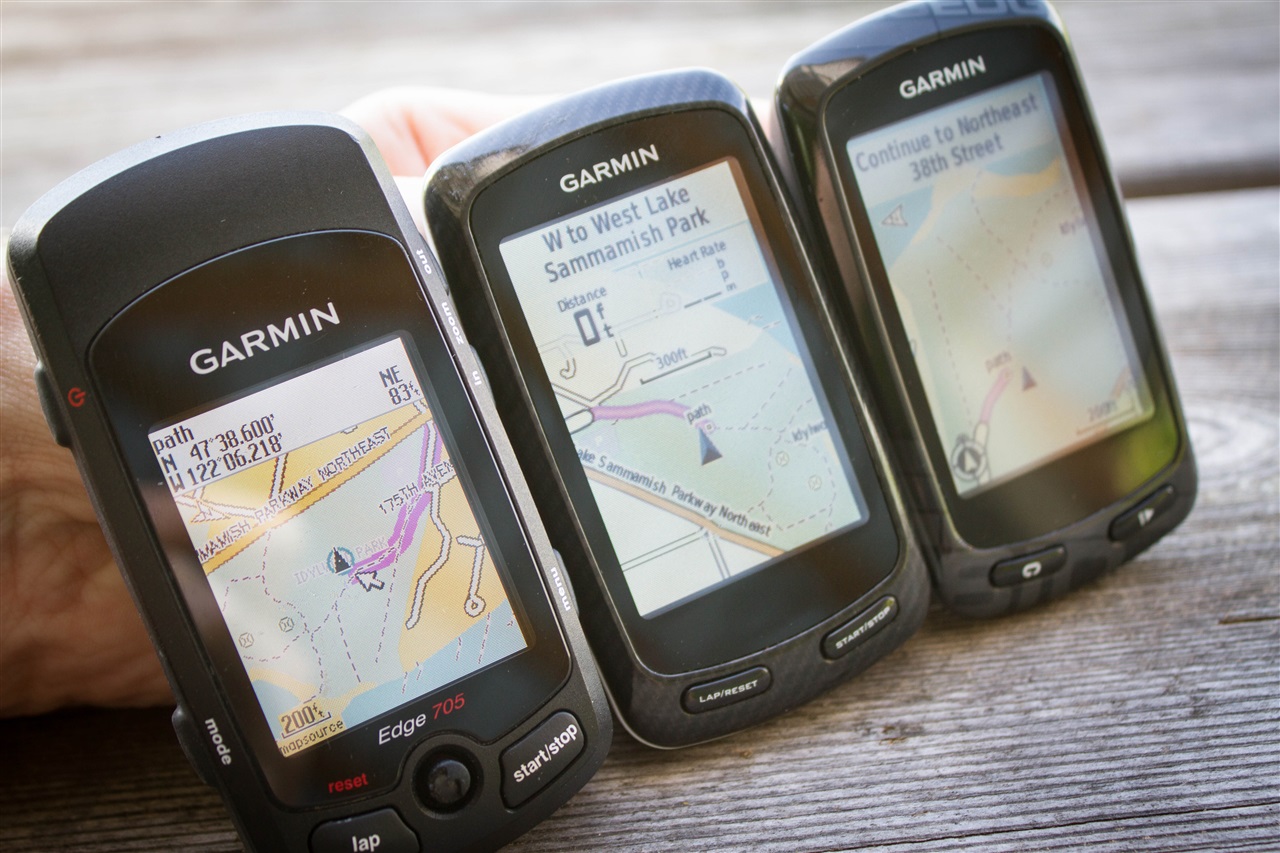
The Garmin Edge series of cycling computers is roughly split into two categories: Those that have a mapping function, and those that don’t. Mapping in this case means that the units also have routable navigation – just like your car GPS does. Whereas the cycling GPS units without mapping may be able to follow a breadcrumb trail, but can’t route you on actual streets or provide visual maps. They’re more like an Etch-a-Sketch than a phone with useful maps.
The challenge though with the higher end mapping units (Garmin Edge 705/Edge 800/Edge 810/Edge 1000) is that as expensive as they are, they don’t actually include any maps. Well, ok, I’ll be fair. They technically do include what’s known as a ‘basemap’. However said basemap believes there are (for example) only three streets in New York City, and two in Paris. Obviously with such completely useless maps, you’re not going to be able to navigate very far – or very accurately.
So instead you need to purchase more detailed maps, typically at a cost of $70-$110 per region/area. The definition of a region varies – both in size as well as the type of map. No matter the case, you’re spending more money on top of what you already spent.
Now there’s always been a free mapping option, but it hasn’t been until semi-recently that the process of getting these maps has been made really easy. I outlined this within the Edge 810 review, but I wanted to call it out and make it more accessible – especially to all those owners of Edge 520/705/800/810/1000 units (also useful if you want to add maps for a region other than you’ve already bought). Additionally, I’ve simplified those instructions some.
So here’s step-by-step instructions for how to get the free Openstreet maps onto your Garmin Edge device.
This page is applicable to all the following unit types: Edge 520, Edge 520 Plus, Edge 530, Edge 800, Edge 810, Edge 820, Edge 830, Edge 1000, Edge 1030, Edge Explore, Edge Touring, as well as Fenix 5X (but not Fenix 5/5S), and Fenix 5 Plus (including Fenix 5s Plus and Fenix 5x Plus).
Requirements:

Despite how long all these screenshotted steps may look, the whole process is actually really quick and super easy. It’s just that I was probably overly thorough in the screenshots.
Active time: 5-8 minutes
’Baking’ Time: A number of hours
Device: Garmin Edge 520, 705, 800, 810, 1000
Storage: A $12 Micro-SD card to put the maps on (omit for Edge 520)
The step-by-step pieces only take a few minutes. There’s a tiny bit of work to get the maps requested, which then puts you into a queue where your map request is processed and ultimately a link e-mailed to you a few hours later. Thus the ‘baking’ time. Then there’s a few more minutes to copy the maps to your expansion card. Of course, there’s no reason you need to sit there and watch paint dry. Just like you wouldn’t sit and watch dough rise.
You can get any size of Micro-SD card. I’ve tested all three Edge units using a variety of cards from 4GB to a highest capacity 32GB cards. I had no issues there with the latest firmware on any of them. Most of the maps you’ll create are less than 1GB in size, so a 16GB card is more than sufficient.
Note that these steps require the Garmin Edge 520, 705, 800, 810, or 1000. All three of these units have mapping capabilities. This won’t work on the Garmin Edge 20, 25, 200, 500, or 510. Those units don’t support the mapping function. Nor will it work on any other 3rd party units. Sorry!
Part I: Downloading the maps
This entire post is ‘made possible by’ OpenStreet maps, which are free community driven maps. Openstreet maps have become in many areas just as good as maps from traditional providers. And best of all, they’re free. The below site simply does all the hard-work that you used to have to do manually a few years ago if you wanted to use OpenStreet maps. Now, it’s literally as easy as 1.2.3.
First up, going to the site. Which, will bring you here:

(Note: There are a few other free sites out there, but none offer as simple an interface, nor as widespread a geographic mapset to download)
You’ll want to then choose ‘Routable Bicycle’ as the map type.
Choose Routable Bicycle:

Now you’ll select which maps you want. Because highly detailed maps like these can be somewhat large, you’ll likely need to pickup a cheap Micro-SD card. Some smaller maps may fit directly on your Edge device, but only if you’re talking a fairly small area. For me, I like to load up maps for anywhere nearby I might ride.
In any case, you’ll start by choosing your continent, then country. In some areas (such as the US and Canada), you’ll also choose the state/province.

In my case, I went ahead and selected North America, then United States, then Washington State. You’ll see how the map then will zoom in and show me the ‘tiles’ that represent Washington State. Tiles are ways that the entire world can be broken down into consumable map chunks. Tiles don’t usually map directly to states, but rather to large swaths of land – ideally designed to keep tile sizes somewhat consistent.
You can see below that it’s highlighted all tiles that ‘cover’ Washington State.

Now, if you plan to venture outside your selected area – or if you want to choose a smaller area, simply enable ‘Manual tile selection’, which allows you to just pick and choose exactly which areas you need.

For my trip to Seattle, I did just this. I narrowed it down to just the local area that I was likely to ride in. This would reduce my download time, as well as my transfer times later on to my device. But, if you plan to have the maps around for a while on your device, choose a larger set so you always have coverage.

Once that’s done you’ll go ahead and enter in your e-mail address to build the map. I’ll explain this in a second.

The service works by generating the maps for you based on your specifications. This means it takes a bit of time, sorta like putting in an order at a restaurant. To do this it places you into a queue, and your e-mail address is simply used to notify you when your maps are ready.

You’ll get an e-mail a couple seconds later with a link that you can go to and check the status of your map creation:

The delay may range from a few minutes to a few hours. No worries, when it’s done it’ll send you another e-mail and you can go pickup your files then:

With that, click on the link to be taken to download the maps. Once there, you’ll see you have a few options. The only one we’re going to pay attention to is the one ending with ‘gmapsupp.zip’. This is essentially a self-contained map file ready to drop right onto your Garmin.

With that, download the file someplace handy (like your desktop or downloads folder), and we’ll come back to it in a second.
I should point out that there’s a ‘Donate’ button on that site (I have no affiliation with it, nor do I even know them or ever contacted them). Obviously, good karma dictates that if you find their (free/community hosted) service valuable, sending a couple bucks their way is probably wise – especially given how much money you’re saving.
Part II: Installing the maps
Note: For the Edge 520, see the next section for the Part II applicable to the Edge 520.
Next comes the easy part. The file you downloaded is a standard Zip file, which means the actual map file is inside it. Just like a package from FedEx. So you’ll go ahead and open up the Zip file to access the map file inside (gmapsupp.img).

Now take your Micro-SD card and insert it into your computer via the Micro-SD card adapter that likely came with it, or stick it into the Edge unit and plug that into your computer and access it via that way. Note, on the Edge 520, you’ll just connect your Edge 520 directly to your computer and it’ll show as a USB drive. Follow the below instructions as normal from there.
When you do so you’ll now have a blank card ready to dump some files on…err, a single file. First you’ll create a directory on it called GARMIN .

Then, simply copy/move the gmapsupp.img file right inside the GARMIN directory on your Micro-SD card.

And just like that, you’re done. Well, do remember to put the Micro-SD card in the slot if you haven’t done so yet.

Ok, now we’re done – for real this time.
Part II: Edge 520-specific instructions:

Now, the Edge 520 is slightly different than all other Garmin units. The reason being that the other units have a micro-SD card slot that you stick the maps on, whereas the Edge 520 doesn’t. Instead it has internal storage (105MB total,~49MB free on a default unit). What you’ll be doing is replacing the ‘Global Basemap’ with one local to your area of riding that’s far more detailed. Note however that you’ve only got about 98MB of space to play with once you remove the 49MB default basemap file. And of course you want to leave some space for your actual activity files, Strava segments, courses, and workouts (all of which are tiny, a few megabytes in total). Simple math is 100KB (.1MB) per hour of GPS activity files.
For the most part, the steps are identical to above, so instead of re-writing them, I’ll just tell you what to do differently. Let’s dive right in!
1) Download the map section of interest per the ‘Part 1: Downloading the Maps’ section (again for the Edge 520, remember to keep it small*: See note at end of this section!).
2) Plug-in your Garmin Edge 520 to your computer.
3) Within the Garmin folder on the Edge 520, you’ll find the gmapbmap.img file (Disc Image File). Make a backup copy of this on your computer for long-term safe keeping.
4) Within the Garmin folder on the Edge 520, delete the gmapbmap.img file (after you’ve copied it elsewhere). Note: If on a Mac, you must now empty your Trash bin, otherwise you won’t reclaim the free space. This is not required on Windows.
5) Copy the gmapsupp.img map file you downloaded into the Garmin folder on your Edge 520.
6) On the Edge 520, rename that map file gmapsupp.img to gmapbmap.img – don’t worry if you can’t see the .IMG extension, just rename it to gmapbmap, like below.


7) There is nothing extra you need to do on the Edge 520 itself as far as configuring maps – it’ll happen automatically, so you can ignore Part 3 of the instructions.
8) Done, go outside and ride!
If you travel elsewhere, you’ll want to either copy back the backup file to the Edge 520 (overwriting your detailed maps), or just download detailed maps for the region you’re travelling to.
*When looking at the size and picking tiles on the site using manual tile selection, you can see the size on the left side. The original map file you’ll delete will be 49MB (gmapsupp.img). After that, you’ve still got another roughly 49MB of default free space to work with (for a total of ~98MB). Again I’d leave at least 5-10MB for activity/segment/workout/course files though – so aim for less than 90MB for your map site.

Part III: Enabling and using the maps

When you first turn on the Edge for the first time with the new maps, it’ll inventory the maps and then make them available to you. Depending on how big a mapset you created, this may take a few seconds – or a few minutes. Don’t worry, just let it complete.
Once that’s done, the map should be ready to use. In the unlikely event your new mapset isn’t enabled, you can do so manually. It’s pretty quick and easy.

Here’s how to manually enable the map layer (again, only if for some reason it’s not enabled), on each of the units out there today (side note: fiets simply means ‘bike’ in Dutch – thus OpenBikeMap):
Edge 705: Menu > Settings > Map > Next to “Openfietsmap Lite” select the checkbox under ‘Show’
Edge 800: Menu > Wrench Icon > System > Map > Map Information/Select Map > Select “Openfietsmap Lite” and choose Enable
Edge 810: Wrench Icon > Activity Profiles > Your activity profile name > Navigation > Map > Map Information/Select Map > Select “Openfietsmap Lite” and choose Enable
Once you’ve got the maps enabled (if that didn’t happen), then you’re ready to use them.
It should be noted that these maps are fully routable, and also include plenty of POI’s (Points of Interest).

To demonstrate this, you can see how I can search for various nearby eateries and find results:


And then you’ll see how it provides routable directions on streets or even paths in this case. For each step along the way it’ll provide ‘Turn left on Maple Street’ type directions:


You can of course always enter in a specific address or other destination, and it’ll route to that. And if you simply have created a course online (you can do that free on Garmin Connect and transfer it to your Edge), then it’ll provide the map information for that course as it routes.
With that, you’re ready to roll (quite literally). Go forth and enjoy!
As always, thanks for reading!
FOUND THIS POST USEFUL? SUPPORT THE SITE!
Hopefully, you found this post useful. The website is really a labor of love, so please consider becoming a DC RAINMAKER Supporter. This gets you an ad-free experience, and access to our (mostly) bi-monthly behind-the-scenes video series of “Shed Talkin’”.
Support DCRainMaker - Shop on Amazon
Otherwise, perhaps consider using the below link if shopping on Amazon. As an Amazon Associate, I earn from qualifying purchases. It doesn’t cost you anything extra, but your purchases help support this website a lot. It could simply be buying toilet paper, or this pizza oven we use and love.


I have a problem with my 810, I’ve transfered the gmapsupp.img under the Garmin folder of the sd card and I still don’t see the map in the 810. I’m using a 64 gig sd card, I’m wondering if it’s the problem ?
Thanks fot your advice.
Indeed, the Edge 810 doesn’t support 64GB cards. Only 32GB and below: link to support.garmin.com
Thanks a lot Rainmaker, with a smaller card, it works perfectly !
Thanks for the clear instruction!
I’ve bought a edge 810 last week and this weekend I wanted to go for a ride. I’ve downloaded some maps, put it on microSD card and put it in the device. At startup I stayed on “loading maps” for more then 30min without going further. Because I made a manual selection that was quite big (3giga), I downloaded a new map (only belgium). When trying with this much more smaller map, it also took a lot of time. Because I had to start with my ride, I removed the SD card and continued without it. So my questions, is this normal? How long does it take? i’ve used an microSD card of 4 Giga.
Thanks in advance for your reply!
can anyone help me please? It stays on the loading maps screen and nothing happens….
Try creating a much much smaller map and upload that. The whole of Australia is only a couple of hundred meg – 4 gig is huge! Are you trying to upload the entire universe’s map? Keep in mind, the bigger the maps, the slower your unit will function as it has to trawl through so much information. Keep them small and you won’t have an issue.
Awesome post, really helpful info – had a great ride through London on this!
One quick question – is there any way of loading multiple maps on the device (i.e. for other countries, France, Italy etc.) as I am planning on doing some riding through Europe? I was wondering if you can just change the file name s and whether Garmin would pick this up, or whether you actually needed to create a custom map of Europe?
Thanks,
JS
The issue might be that there are multiple openfiets map files on your device. The instructions on this page still work for my device. Good luck!
I used these instructions in 2013 when I first bought my Garmin 800, and it worked great. Recently I’ve tried to add maps for HI and CA, and both times it has not worked at all. The download and unzipping process went fine, the .img file went into the Garmin file on the SD card (right next to the successfully loaded map from 2013), but when I look for the map in settings, it only shows the original base map and the first OpenFiets map from 2 years ago. No matter where I put the file on the card, or what I name it, the system won’t recognize it. Any thoughts?
@hankyp the issue might be that there are multiple openfiets map files on your device. The instructions on this page still work for my device.
@dcrainmaker Thanks for the article!
Thank you for the great information. Does anyone know if this will work with a Garmin 1000? Thank you!
Yulp, it’s how I do it when going to other areas now included on my unit.
Great! Thanks for the info. Will the Garmin 1000’s features work the same with these maps as it does with the regular maps that were originally included? More specifically, will the Round Trip Routing and on unit Route Planner be compatible and function the same? Thanks again for your great blog and information.
Yup. In fact, dirty little not-so-secret is that the Edge 1000 maps are identical to the ones in this post. :)
“the Edge 1000 maps are identical to the ones in this post”
The maps on my Garmin Edge 1000 are definitely NOT the Open Street Map ones. They’re Garmin Cycle Map EU 2014.20.
They give some navigational problems, and Garmin have suggested that I try instead using the Open Street Map ones.
In January 2015, Garmin Support UK told me that the maps on a Garmin Edge 1000 were not the same as Open Street Map. They’ve now told me that they ARE in fact the same.
I’ve downloaded the OSM for a section of Australia (Adelaide and suburbs). When I try to navigate I get Error “Route Calculation Error……Maps do not have routable roads in this area”.
Any ideas?
Adelaide is a city with some 1m+ people so not just desert!
Thanks for these. I’d managed to transfer a map to my 810, but couldn’t work out how to enable it as the only instructions I had were for an 800. Your instructions for the 810 are spot on. I got straight into where the maps was and found it was enabled already! Great.
Thanks so much for this information. You saved me some good money, that’s for sure! It worked very easy and your details were spot on! I also donated a few bucks to them! Thanks again.
Erik
Wow,
Simply amazing instructions and maps, they look and seem to work really well.
Thanks again….
Have to say instructions were spot on the only issue i had was that the sd card was WRITE PROTECTED which wouldn’t allow me to open the files,but after typing my prob into the tinternet… BOOOOOM!!.. card unlocked,maps downloaded onto my 810 and bingo !! working fine,would never had been able to get this far without the instructions provided by dcrainmaker!
cheers dude
So easy and quick. Thanks man!
Ray FYI this post doesn’t appear when you look for posts tagged with Garmin Edge.
link to dcrainmaker.com
Great goto post, used it a few times now.
Thanks, updated!
Awesome tutorial and an awesome site. I just bought an 810 and decided to go for the open source maps because of this. Thanks to you (and the people doing the open source work!) I’m $50 ahead. I plan to donate a portion of that to the open source project, win win.
So i bought 2 used Garmin Edge 705 units from Ebay (the 2nd for my brother). Came across you instructions on how to acquire the free maps and load them into a Micro SD card. Your instructions are very clear and you saved me a few dollars. Very happy camper here! Thanks for sharing.
Vic.
Worked like a treat, as always you the man!
Thank you so much Ray for your excellent and easy to follow guide, must have taken you hours to put together, saved me a bundle which i can now spend on my bike :-)
if i see that Eric Scharlow out on my ride ill just spit in that ignoramuses eye for you
So awesome that you took the time to put all this together. Huge good karma points for sure. I tried the steps a dozen times and it would never work. Got a little frustrating for me so I finally called Garmin and complained that after spending over $400 for a device made for cycling navigation that it does’t even come with the maps that allow you to navigate at all. They felt bad enough that they just sent me their maps for free! Catching bees with honey, boys!
I just want to say thank you for this. I followed your directions and it worked perfectly — and not only that, it worked perfectly on my GPS, which is an Edge 605, not one of the models listed here. My 605 is pretty old, and I figured I was never going to be able to update the map on it, but now I can. Not only does this save me the $$$ to buy a new GPS, but it will keep my perfectly good GPS out of the landfill for years to come…until the battery no longer holds a charge. THANK YOU!
Quick Q-
I have maps of my local area saved on my memory card, I am downloading some new ones for a trip around Europe this summer- what will happen to my original maps? Will this file be added to them or will I need to reload when riding in different areas?
Ive followed the instructions and download the maps successfully, however when I try to use them for navigation purposes, either following a pre created course which Ive saved to my 810 or from an A to B point of view selected from the unit, the directions are always wrong. Im always told Im off course or to turn around, even when Im clearly on the right road. Has anyone else had this issue? Any help or advice would be appreciated
I don’t have a solution, but I have had this exact problem when I use the unit for navigation. The maps and GPS show the correct location just the directions are wrong. I’ve experienced this with routes that I have downloaded and ones that I have created my self. Kind of glad to know that it’s not just me. Be even glader if there anyone out there has a solution!!
I just installed the maps I wanted on my sd card and I cant see anything in the edge 800. I slike nothiung was installed, but it does show on my pc I have the file on the sd.
What could be the problem?
Check the format of your card. I needs to be FAT or FAT32. If it’s not you’ll need to reformat and then recopy the .IMG file in.
Thank you, sir! I ran through the instructions – didn’t work the first time but I scanned the comments and noticed I needed to double check my card to make sure it was formatted as FAT32 (garmin doesn’t like exFAT apparently) Boom, dynamite. I’m in. Thanks for taking the time to put this together, it saved me a bundle on a Garmin map. Planning on sending some bread and GPS traces to the OpenStreet project.
Maybe it was growing up in the computer age, or maybe it was that programming class in high school, or just using computers for work every day for 10 years, but I’m with you, creating a directory and copying a file in a Mac or PC environment is assumed knowledge, considering the tutorial is posted on a website. Eric Scharlow is rude.
Thanks again!
I don’t think I’m doing anything wrong, but I can’t get this to work.
I’ve downloaded the gmapsupp.zip file to my Mac which automatically saves as gmapsupp.img. Have copied to an 8gb micro SD as described above, but my Edge 810 doesn’t display the maps as an option.
Any ideas?
Thanks
I’ve done it!!!! Not sure what I’d done wrong but its sorted now!
Lucky u, haven’t been able to get mine to work. I’m using a 4G sd thou.
Great article. Which is the better file to download for an Edge 810, GPX or TCX?
What’s difference between generic routable and routable bicycle maps please?
Hi,
I have tried this many times over but I am unable to complete the process. I am able to get the map transferred onto the SD card but when I go to turn on my garmin with the SD card inserted, I cannot view or select the base map that i have downloaded onto the SD card. Any help would be hugely appreciated. I am using a garmin edge 810. Many thanks, Joe
Have just seen about formating SD card so will give that a go, fingers crossed.
That’s the exact same thing is happening to me and haven’t been able to figure out the problem. Haven’t been able to use my gps because of that.
Hope we can find the issue.
I tried that and,it didn’t work either :(
I even try to format as fat and fat 32 and nothing.
Hi. I had the same trouble and eventually worked out that I hadn’t put the downloaded file in the “Garmin” folder on the SD card. Once I did that it worked perfectly.
Thanks DC Rainmaker. Very clear instructions – great job!
I’m still no able to see the maps on my gps. Now when I put the sd card on my pc its showing that the disc image file is corrupted.
I will be leaving for a 1 month vacation to yellowstone park, utha, colorado, and some other places and need to get this done before we leave in 1 week.
PLEASE HELP!!!!
No what I ddi was to try to open the downloaded map on my pc and its also showing the same thing “the disc image file is corrupted”. Can’t understand what i’m doing wrong.
Finally, I was able to somehow get it to work. But I have a question. I live in Augusta Ga and we have a very nice and recognized trail system call FATS (Fork Area Trail System) and I can’t see it on the map. Is there something I need to do to be able to see the mtb trails we have in our area?
Since we are going for a 1 month mtb trip I would like to be able to see the trails as I don’t know them.
Here is a link for ours link to sorbacsra.org
Thanks in advance.
JR.
Just want to say thanks for sharing such info. I got the map working on my newly acquired Edge 810.
Going for a ride now.
Guys i need some help, i followed the instructions stated above, however, when I turn on my Edge 1000 it says that it cant unlock the map! And the new map in my sd card does not appear in the map screen. As if its not in the sd card at all. However, when i read the sd card in my mac it does appear in the Garmin folder.
Any clue to solve the issue?
Thanks in advance!
Excellent stuff man ! I’ve just gotten an Edge 810 and this will be my kickstarter.
Question: The server limits the size of map, or number of tiles that can be marked to make a map. Can more than one file be stored on the SD card and accessed by the Garmin? Or does one have to change out maps when going to a different location?
Thanks for sharing this! Worked perfectly for me on a secondhand Edge 800.
Thank you so much for sharing your wisdom. Without you I would never have found out how easy it is to download and install openstreetmaps. That saved me money big time!
I am Chinese user and how to d/l map with tradition chinese language?
Hi David, For a start have a look at this site link to velomap.org
Their maps display in the local language on Garmin GPS units. In the case of China place names will appear in simplified Chinese (not traditional Chinese, not English or any other language).
Let me know via this forum if you need any more help after you have looked at the Velomap site. Be happy to help you.
88
Graham
Thanks for reply. But I got reply from moderator and told the map only available in english language (for openstreetmap)
May I know velomap is another free map I can d/l for my Garmin 1000 appear in local language?
Thanks (Sorry as I am newbie but original china map was outdated as at 2009 and I need a update map)
Hi again David.
I’m so sorry that I gave you incorrect information. I was working from memory without doing proper checking :(
Of course the moderator at Velomaps is correct – names only appear in English. I asked about this about a year ago as I too wanted Chinese language display.
I ended up using Osmand version of the map on my android phone. On the ‘configure map’ setting it is possible to select the display language for place names. I’ve just rechecked on my phone and successfully switched between Chinese & English display.
Once again, sorry for incorrect info in my original reply. If I find any maps for Garmin units which display in Chinese I’ll post details on here.
Graham
This works prefectly! Thanks from Portugal!
Thank you DC! Saved me a bunch of money and after a few months of owning the edge 810 Ive finally got the time to install maps. Ive just been using the surface features of this robust technology. Im willing to learn all there is to about my unit. I think reading all these comments will get me up to par as well as your reviews. You must be a very patient person. Happy roads!
I’m using an Garmin Epic, so no SD Card.
Usually, mapinstall work for those files. Not now on my mac. What can i do?.
I’ve a .img file but can install it…
Thx,
Steph
I’ve got it working – download the file as above, unzip it then just copy it to your Garmin when it is plugged in (i.e. treat it just like a USB stick). It goes in the folder called GARMIN, there should be other img files there too.
I assume the previous post was talking about the Epix, not Epic, but if not, has anyone tried this (or any other technique) with the Epix? The original “hands-on” post said 3rd party maps would work but the only link brought me here. Any help would be appreciated.
please help a technophobe!
I am downloading the zipped gmapsupp file however if i try to extract the file says its corrupted?
be patient with your answers and use big letters please :)
hi
Zip files states I need a password
Typically if a zip file asks for a password, it means that the file might be corrupted during downloading.
DC Rainmaker, FYI. I just tried this out for a Garmin Edge 510 (note not 520) and it appears that the 510 also supports background maps. Obviously you’re limited to the amount of space available on the 510 as compared to the 520.
Wow, that’s a crazy change. I wonder when they quietly tweaked the software to support that…interesting, I’ll have to poke and find out.
Went out after said install of basemaps. Had full on navigation. Heads up details of next turn with ‘white arrow’ direction pointer. Limited space but used further tools to the ones you have suggested to use a specific bounding box output from OSM. Also possible to gain an extra 5MB by removing further language support in the ‘Text’ folder. Was originally upset at recently buying 510 only to see 520 come out. However, thanks to your post I couldn’t be more pleased with the 510.
How did you manage to get the roads to show up?
Are you using the a .img file? or a .kmz?
With the .img as Ray explained I’m not able to see the roads at all…
It seems that I’m not alone: link to forums.garmin.com
Yes I played with this late last year on my 510, see this post and ones in previous page or two. Apart from it being a bit delicate, and needing the site mentioned to create an img file small enough to fit I could never get the streets to display, see the screenshots , has anyone actually got the streets showing, which format map?
link to forums.garmin.com
Otherwise good stuff DC
Jon, I see from your screen picture you have indeed got streets showing, at least for the popup turn warning, do you also get them on the map when just navigating, which format OSM map did you use and from which site. I have played again today, my 510 now has 3.40 but still no streets displayed like on your photo, thanks
Any idea if this works with software version 5.0? I’m having no luck getting maps to display on my 510.
PS as shown on the Garmin 510 forum (link above) my 510 does recognize it has an OpenStreetmap and it shows features other than streets (toilets, coffee shops, coast line, parks…and it knows the name of the street it is on and the name of the street for the next turn (using only GPX for the course) but it does not show streets!!
Late Starter et al you’re definitely on the right path. I had the same situation as you. Make sure you have the latest software first. In ‘normal’ map view I too get a very high level map. If you however create a tcx file (ridewithgps) and use that as a course everything then hooks up. When starting the course I get a ‘calculating x%’ notification. Once this hits 100% I’m up and running with street view and satnav like directional info. Good luck.
LateStarter. Just re-read your post. Sorry was just about to go out on a ride at the time and was writing the above on my phone very quickly. I can see that you are indeed following a course based on your attached image. Therefore all I can assume is different is that I am on software version 3.50 see link to www8.garmin.com. There is a line in there namely ‘Made several improvements to course routing and general course experience’. I am hoping this is when the extra functionality for course routing was implemented. I’d be very interested if you get this going, please let me know. JB
Tried to create a map using opentreetmap site.
I get the status email but never get the completed link. Am I doing something incorrectly/?
It can take up to a couple of hours after you get the status email before you get the link. You need to be patient. I have found that the first status update usually way overestimates the actual time. So, e.g. the first status update might say 6 hours, but then it actually only takes 30 minutes.
Cheers
Unfortunately I get the message link. It says that the map has already been created and I should have gotten an email with the download link. But that email has never arrived. I’ve tried it serveral times to no avail. It has been over a day. I think something is wrong.
Hmmm… That is unusual. I doubt it is a SPAM folder issue since both the initial tracking email and the email indicating completion come from the same sender, lambertus@sfs4.pleiades.uni-wuppertal.de, so if you receive one email, no reason your spam detector should capture the 2nd one, but worth checking just in case.
I created 4 maps today without a hitch.
Here is a link to resources for ‘help’ on OSM (e.g. facebook page, google+ page, Linked in, etc):
link to wiki.openstreetmap.org
Hope you figure it out soon.
Does anyone know if there is a limit to how many .img files the Edge 800 can recognize from the microSD card? I installed 3 files all of which can be seen in Windows Explorer. Each is about 3 GB on a 16 GB card. On the Edge 800 I can only see 2 of the files in Settings/Map Information/Select Map, plus the Base Map. I tried deleting the 3rd file, renaming, it to gmapsupp.img (the other 2 have different names), tried a smaller file (118 MB), all to no avail. So I am beginning to wonder if maybe the Edge 800 will only recognize 2 img files besides the base map? Any thoughts? Thanks very much
I followed the instruction step by step. When I get that second email stating te map is ready, wen I click on that link I am taken to the page whcih lists a bunch of files, but I am not seeing the gmapsups.zip file that you referenced as an option. Not sure what to do next.
The file name may not be exactly “gmapsups.zip”. It may be something like
“osm_generic_gmapsupp.zip ” or some other prefix. So long as the filename ENDS in gmapsupp.zip, that would be the one. Is there nothing in the bunch of files like that?
I just purchased a 1000 that has a Europe Base Map. I have downloaded und unzipped a base map for California. When I turn on the Garmin it gets to the screen that says “loading maps” then freezes. I have updated the Garmin software (3.10) and the California map file is on the micro sd card (“gmapsupp
is the filename and is in a folder labeled “Garmin”).
Any ideas?
Brilliant information for maps. Having recently moved to Thailand I was struggling to find an sad map card. Thanks for taking the time to compile such clear concise instructions which made this installation easy.
Noticed there was one disgruntled post…free maps and instructions on how to install. Can’t please everyone all the time!
Thanks again.
Jim
Send courses from iPad to Garmin Edge 800 for 30 (well spent) bucks
I recently purchased an Edge 800 after my iPhone overheated for the 8th time while biking on a sunny day… I have seen a few posts on the web about folks wishing they could send a course from an iPad to the Edge so they wouldn’t need to lug a laptop while traveling. Here is a way to do it. It does require the purchase of a quite amazing device: link to kingston.com
Disclosure: I have no ties whatsoever to Kingston; I do feel that they make dependable products with a high value:cost ratio.
I researched the Kingston MobileliteG2 device when I needed a way to email photos from a digital camera while travelling. I wanted to transfer the photos to my iOS device easily. Eyefi-type cards are good for this, but they are expensive, there was a latency issue for me that caused many photos to get corrupted, and the network setup is cumbersome. The Kingston device allows you to use a fast SD card in the camera and is easy to set up. Then I thought—maybe the device could be used to transfer a gpx file from the iPad to the Garmin Edge—and I was excited to find out that it can :) So for little more than the cost of a ‘regular’ 4600 external battery charger (which this Kingston device can function as also) you get a “Swiss Army Knife” that has all the functions described in the above link. It is available for $30 from Amazon link to amazon.com
Here are the instructions I used. While it seems like a lot, it is all actually very intuitive once you’ve done it a couple of times.
1. I used MapMyRide in Safari on the iPad to create a route. Here is a good post on how to do this on a PC- it is similar on the iPad- just a bit more tedious, but still doable: link to spoke2spoke.com
2. Download the Kingston Mobilelite app from the App Store onto the iPad
3. Set up the Kingston Mobilelite (hereafter Kingston) using the excellent instruction booklet included with the device
4. Once all 3 lights are steady on the Kingston (yellow, blue, blue), go to iPad main Settings, select WiFi, select Mobilelite Wireless to connect your iPad to the Kingston wirelessly
5. Plug one end of Garmin Edge cable into the Garmin and other into the USB port on the Kingston
6. Back to the iPad- find your route in My Routes on MapMyRide in Safari
7. On the right of the screen, under Route Info, click ‘export this route’
8. Export as GPX
9. Download GPX file
10. Click “Open in…”
11. Slide top row of apps til you find “Open in MobileLite” and press that
12. Select the route you just exported
13. At very bottom of pop-up window, select middle icon (looks like 2 squares with an arrow between them)
14. Select USB drive on next window (remember, your Garmin Edge is plugged into the USB port of Kingston, not the SD card port)
15. Press Garmin
16. Press Newfiles
17. Press Copy
18. Exit Mobilelite Wireless app
19. Disconnect Garmin Edge
Power on your Garmin Edge, and your route will be in Courses.
Hope this is helpful to some folks…..
Cheers!
Hi,
Great guide! Thank you! I have followed it successfully several time now… which has led to my question!
I have several maps loaded, for UK mainland, Alpine region etc etc, and I have renamed the .img file to meaningful names, but on the device (Edge 810) they are all called “Openfietsmap Lite”. Is there a way to rename this? So that each map file can be distinguished easily on the device?
Many thanks
Rob
Rob
This will allow you to manage your device including giving your maps sensible names:
link to javawa.nl
Great web site and tips Rainmaker, and very easy instructions. Any ideas how to take routes done off a garmin705 via the SD card would be appreciated folks? My USB link wont connect to a computer any more.
Thanks for this post Rainmaker!
I was able to get the maps on my edge 810 quite fine.
Later this year I am travelling to Germany and have booked a self guided bike tour. The tour guide has sent me all of the GPX maps, but I don’t seem to be able to upload them via garminconnect.
I was wondering, if I add the maps to the Garmin folder, will that work? I did try adding them to the course folder, but it didn’t seem to want to copy there.
Any idea how I can get these courses on my device and also view them on garminconnect prior to my rides by any chance?
Thanks for the help!!
I believe you need to copy the courses into the NewFiles directory under Garmin. The Edge software then copies the files to what it thinks is the correct directory (in this case, Courses) when the Edge is restarted.
That is what I have learned….
Legend!! Thanks for the quick reply Colin.
I will give this a go when I get home from work today! I was getting a bit nervous that I had to rely on the old fashioned paper maps for my trip.
Cheers
Worked perfect. Downloaded the maps for Canada > Ontario and loaded them onto a 16GB microSD and my Garmin Edge 810 picked them up on first try using the manual mode to enable them. Thanks so much.. going to test them out over the next few weeks and see if they are as good as the Garmin maps.
WOW!
Absolutely brilliant.. bit apprehensive about the process but it was actually quite easy, worked first time with no problems. Don’t know how accurate the maps are but they do seem to be pretty much perfect.
THANK YOU
I enjoyed your review, thanks! The ability to add third party base maps is fantastic. Is it possible to do this (i.e. add fully routable third party basemaps, without turn-by-turn) on the Garmin Fenix 3 too?
Garmin just released a new software version for the edge 1000, does anyone knows if there will be an impact on the maps downloaded from other sources but Garmin if updated?
I was unsuccessful in using this with the Edge 510. Not enough space. There was 13.1 MB of space available and the smallest file size I could generate was 13.2 MB.
Does the 510 support maps?
Hi Guys,
This looks like it will be awesome but on my mac i can’t open the file. anyone else having this problem ?
thanks
All good now I just dropped the file strait onto the sd card and works a treat.
Thanks so much
Top job, DC Rainmaker, I now have a map of Long Island on my European Garmin 1000 and looking forward to my holiday even more! Thanks for all the help, and for saving me money!
Many thanks for the Introduction to the new Garmins. I’ve had the 705 since its birth, but the rubber buttons perished making it beyond econmic repair. The 810 is amazing, your instructions are clear and faultless, I can’t believe some people are having a moan about the intructions.
Off to guide a group around Todmorden this weekend with Skyride, looking forward to it, as we have some beautiful places here in England.
Brilliant! thanks so much for this, it worked perfectly first time.
Garmin 520 Mapping Question- I was able to get the map downloaded from openstreets very straight forward and easily.
I’m not sure where exactly to put the map in the 520 though. I have tried the custom maps folder and outside of the folders as well but the 520 doesn’t load the map. Any help would be greatly appreciated. Thanks!
echoing Brent’s question. New 520, got the maps but not sure where to place the file to get it to load. Tried Garmin folder on the 520, New Files folder but to no avail. File is there just not read. Also no menu selection under settings to select different map files. Anyone figure this out?
Place the gmapsupp.img file in a directory called garmin. Wether you choose the device itself or the sdcard. I keep everything on sd card.
Richard:
The Edge 520 HAS a folder named Garmin so you cannot create a new folder at the root level also called Garmin.
Here are the things that I have tried:
-Created a folder called Garmin within the root level Garmin folder. Didn’t work
-Placed the file within the Garmin folder at the root level, didn’t work
-Placed the folder in the New Files folder. Didn’t work
-Placed the file in the Custom Maps folder. Didn’t work.
Has anyone made this work on a 520? Part of the issue is not knowing which map database is open. There doesn’t seem to be any way to see that. Also, no way to choose different database unless I just haven’t stumbled across the menu yet.
Thanks again.
So it looks like there’s been some slight tweaks in the way this is working on the final versions of the Edge 520.
Out of curiosity, does this work:
1) Make a backup copy of gmapbmap.sum & gmapbmap.img
2) Delete gmapbmap.sum
3) Copy the gmapbmap.img to the Edge 520
Thanks Ray. Before I do this let me make sure I understand your instructions:
1) Copy both
2) Delete just 1?
3) You say to copy gmapbmap.img to the Edge but do you mean to copy the gmapsupp.img file to the Edge?
Cheers
3) Yes, meant that.
Sorry – translating some instructions from someone in the know that sent them to me last night and I don’t have a 520 on hand at this second to triple-check myself how it is on the final firmware. Thus…this was a hail mary. ;)
Here is how I got it to work (I hope….):
1) Removed gmapbmap disc image file from 520.
2) Put the gmapsupp disc image file that I made and renamed it “gmapbmap”
Turned on garmin and it seems to work.
Hope I didn’t mess anything up. A big benefit is that removing the installed basemap opens up a lot of room on the device.
Ray:
I tried your method and it did not work. I tried Craig’s method listed below and that DID work. I am hopeful that replacing the original map flle will work if I choose to go that route later (pun intended).
Thanks for the help and I will follow to see if you come up with another easier way to do this.
Cheers
Sorry Brent, it was your method, not Craig’s. Have to give credit where credit is due…
Alas, I tried Brent’s method (but I was dumb enough to miscopy the original gmapbmap.img, so now it is lost). It didn’t seem to work for me. I see the OSM copyright note when the unit boots, but then a dialog pops up that says “Cannot unlock maps.”
Yes- this is the trick… nothing loaded until I deleted the .sum file (after saving a copy on my computer). Now, my local custom map shows up great! Thanks for breaking this down.
Any mountain bikers out there: is DLing the maps from VeloMaps really that good for trail riding? I looked at it, but it seemed like a steep learning curve and I wasn’t sure I wanted to get into it, if its not worth it. Thanks!
I am also having an issue with the maps on the Edge 520. I have tried loading the img file in the garmin folder but it does not see it. I am considering just putting the base map back until a solution is found.
Craig – would you be willing to email me you basemap file? I accidentally deleted mine while trying to get the osm maps to work? Please, you (or anyone else who can send me the std gmapbmap.img) would be my hero ;-) unclesocks@gmail.com
alas – I can’t delete the previous comment. No need to send me the map file, I’ve fixed the problem (see below)
Hi – I have been trying to download a map for Italy to my MAC book pro, however when I down load the .zip file it ends up as a .gmap file on my computer. I have tried loading this to my Garmin 800 but I cannot see the map. Any ideas?
Can I do this with a NUVI 255W? Load Europe maps, I mean.
Thanks very much!
Thanks for sharing! About to go to a new area so requested new maps – all downloaded onto desktop and then onto Garmin 810. Maps are there, however they aren’t routeable (I downloaded routable bicycle maps). Any suggestions?
Thanks in advance!
Can I replace the current gmapbmap.img on the device or must I use micro-SD
Does the Garmin Edge 520 have a micro sd card slot?
And how much internal storage does it have on it’s own?
Thanks
No micro-SD card on the Edge 520, you have to put it on the internal storage (not much).
I removed the gmapbmap files from my Edge 520, unfortunately for some reason they have gone from the file structure, but have not freed up any space. As such I cannot either add the new gmapbmap file or replace the original files. As such zero maps at all.
Would any kind person have any recommendations?
Thanks
Rob – I bet when you ‘deleted’ the file it was merely moved to a trash folder. Try emptying trash for that USB volume, which should really free up the space. That said, I followed the note here about replacing the “gmapbmap.img” file with the OSM version. But now I get a message about “cannot unlock maps”.
So maps on my new 520 seem completely busted. Anyone have an idea on how to fix?
Actually – mystery solved. It works for _some_ osm generated map files. One file I generated was 50MB, and it printed the message about “cannot unlock maps.” But if I only did most of the SF bay area (to reach 18MB) it was then happy. Yay!
Awesome guide. Thanks a lot! ))
Great instructions and donated as suggested as saves loads of money. One thing though it would appear that the process is slightly easier now. You do not receive any email. Once you have selected the maps there is a download button which takes you straight to the folder.
Shame about the people that think this is complicated!
Great instructions! I have a new Edge 520 (without the SD card slot and limited space) so my main cycling area is dead center in the middle of several large tiles that exceed 50MB. Does anyone know if the loadable IMG file can be edited down to remove areas that I simply won’t ever be riding to? Thanks so much!
I just used Brent E’s instructions and it worked perfect
“1) Removed gmapbmap disc image file from 520.
2) Put the gmapsupp disc image file that I made and renamed it “gmapbmap”
Turned on garmin and it seems to work.
….A big benefit is that removing the installed basemap opens up a lot of room on the device”
My new map file was 68mb but removing the original basement freed up 50mb so this new detailed basement (of my normal riding area) only added the 18mb difference. Thank you for the help!
I was having similar problems getting OSM on my 520 and found success using Brent’s methodw. I just made extra sure to back up the original base map just in case! Thanks for the help Brent!
I’m finding that on occasions, which seem to be random, the maps disappears even though the SD card is still inserted and the text says ‘loading maps…Open Street Maps’ when the Garmin powers up. Anyone else had this issue? I’ve checked that the maps are still enabled. My device is a Garmin Edge 1000.
WOW! What a great explanation. I have been screwing around for hours without success. I tried another google search–found DC Rainmaker (who’s 2013 review of the 810 convinced me to buy it) and there it all was. Within minutes I had it done. It worked. Thank you so much.
Garmin 520 first impressions & maps
I had trouble getting OpenStreetMaps to work on the new 520 so I headed here…only mistake I made was starting at the top of the comments and reading through 300 posts before I saw to rename the gmapsupp.img to gmapbmap.img. Was necessary to delete (and empty trash) the original gmapbmap.img before renaming the new file. I made a backup of the original, but assume I probably don’t need it because it will probably get restored if I do a full device reset, but I don’t plan on finding out unless I start having issues.
I’ve only ridden 30 minutes with the new 520 (thanks Clevertraining/DC for getting it to me so fast and at a discount!). Was interested to see how it handles overlapping Strava segments…appears to only catch the first one and ignore the subsequent ones, so I went into Strava and made sure to only put stars on the ones I want to see and made sure they don’t overlap. I also disabled a segment during the ride and when I passed it again, it still started up. Oh well, wasn’t expecting perfection out of the box.
I can confirm the data fields are MUCH easier to read than the 510. You can also view your historical data while you are in the middle of a ride, though I’d recommend pulling over first :) That was something that occasionally annoyed me with the 510. Also, the way it handles sensors (pooling) seems much better than matching each sensor to a specific bike profile. If you pick up multiple sensors of the same type, it just asks you if you want to switch from the current one to the next one. Helps if you have them named so you can recognize which one is which.
All in all, I’m loving the 520 after having it for only 24hours, compared to my old 510. I’ll have to get used to the buttons, but that shouldn’t take long. I should also mention that with the K-edge aero mount, I am still able to hit the bottom buttons, although they are quite close to my bars. Hope this long-drawn-out review helps someone.
Mike
Apologies, I should have posted the bulk of my comments under the Garmin 520 page, rather than the maps page.
Mike
Hi All-
I’ve added in an Edge 520 section into the post, which details how you install maps on that. You’ll find that section here: link to dcrainmaker.com
Enjoy!
Thanks, Ray, for posting these great instructions. Your 520 specific instructions were a bit late for me (that’s what I get for being and earlier adopter), but thanks to Brent E. I wasn’t confused for more than 24 hours.
Cheers!
Found by Google after a suggestion from another user and using my (new) Edge1000. Instructions worked perfectly – although no email required as I could immediately download the files. Went straight on to my Edge 810 with the appropriate re-starts – necessary for Garmins to find new files – and I now have open street maps on it. Might have even saved buying the 1000 had I seen earlier, although the significantly larger screen of the 1000 makes it worthwhile.
Thanks for publishing such straight-forward OSM instructions that work so well.
Is anyone else seeing where the tile boundaries change periodically on the OSM Routable Bicycle map?
I’m also seeing where selecting certain tiles will automatically include an adjacent tile, and vice versa.
Is it just me, or is anyone else seeing the boundaries change periodically on the “Routable Bicycle” map at the OSM website?
Also, where selecting certain tiles automatically selects an adjacent tile (and vice versa)?
Just downloaded a map of South Korea for a Mac. which part of the download to I put on the SD card.
I put the .zip file on to the SD and the garmin 810 is saying “Loading maps”. For about 1/2 hour aleady. How long does it take.
You need to take the file out of the .zip file.
Hi DC Rainmaker
I have unzipped and placed the the unzipped version into the sd card but nothing shows up in 810.
I think some where in the zip/ unzip area is a problem but I dont know what.
Can you guide me a little please
Thanks Bernadette
Hi Rainmaker, Thanks for the instructions/guide on the mapping thing, I am in the Netherlands and tried to use your process for the Zuid and North Holland provinces (several blocks). The Website indeed created the map and I managed to download and put it on my micro SD card on the E800 (using Finder MAC OSX) while I had Basecamp open and watching it for the change.
All seemed to go well, but when I loaded the map, the top half seemed to be completely missing (hashed out). I retried to transfers but got the same result. I have just loaded another map to see if I get the same problem. Do you know if I need to do something to avoid this or when this might happen? Any words of wisdom would be highly appreciated. Thank you! Also for this excellent guide… Very good, would be lost without it…
Where do I find your “donate” button. You’ve helped me so much with setting up my 520
great site just started getting well in to my road biking after a long lay off, in love again,
garmin map link page is excellent no more base maps only.
Hey There,
Can anyone provide me with a list of the files that are in the “Garmin” folder in a stock 520. I think I may have added an extra map file when trying to change from the base map to more detailed maps as the above post suggest. Now I’d like to clean it up.
Thanks in Advance
Great site really informative
Tried this, worked just as easy as you say, though I went for the direct download rather than mail.
How do you get the POI etc. I have an Edge 810
Thanks for the tips,
I have a 520 and a MAC and haven’t been able to locate the ‘garmin’ folder when I plug the 520 in.
Even using Houdini (let’s you see hidden folders and files) I haven’t been able to locate the 520 folder to swap map files. Does anyone know how to get around this?
Thanks
Hi Ray,
please mention in the guide, that copying to SD card inserted into Garmin, instead of a card inserted directly into a PC is soooo much slower.
I’ve spend over an hour tearing my hair out, testing different SD cards, running benchmarks as I thought that is an issue with my Garmin 810 (which has its warranty just expired).
But now, as I’ve just benchmarked my old Edge 500, I believe it’s perfectly normal.
Of course Edge 500 has no SD card slot, but I was benchmarking transfer speeds of headunits internal memories as well.
Thank you sooo sooo much. My new Garmin Edge touring plus never worked properly. I installed a map using your guide and it works perfectly all the time now. I also got maps for the Canary islands for my holidays too. Brilliant guide and well done for all your effort. Much appreciated. You saved me from chucking the thing in the bin…. Thanks again…
What can I say but a massive thanks much appreciated . Absolutely fantastic just what I was looking for …. now when i’m dying like a dog in the French Alps at least me and my bike wont be lost. Thanks again
I’m having a problem loading the OSM maps into the Edge 520. I scrolled thru all 484 comments looking for “cannot unlock maps’ error that shows on startup of the 520. I followed all the directions to the letter, and have the OSM file renamed to gmapbmap and removed the original garmin disc image file. I also tried adding the file extension in the name to see if that made a difference but no go.
It appears that some people have success, but I’m having no luck
Is there a work around for the “cannot unlock maps” error?
thanks
The downloaded file from the OpenStreetMap website was a folder called “openfietsmap_lite_tiles”. All of the img files are nested inside that folder; it appears that each map square that I ticked became a separate folder. (Perhaps that website has changed??) Thus, there is more than just one image file. How do I get this properly into my Garmin 520? Do I copy the folder with files or only each individual img file? Please advise.
Garmin Edge 520: Help me!! I cleared the gmapbmap.img file after saving a copy. installed a new map by copying the gmapsupp.img file (35mb) and renaming it. When I went to reverse the process, it is saying that I don’t have enough memory. I now can’t install any map file at all. Please help
Hi, yes I have the same problem. After removing the base map file when I try to copy across the new file I have created it says there is not sufficient space on the 520. The files I have tried to make are no bigger than 60MB. I have just made a smaller one (41MB) to see if that does the trick.
I have been right through the 520s file structure and as Ray suggests it should mean that I have nearly 100MB free but if you look at the basic properties of the 520 it seems to think there is only 51MB free despite the base map file not being there. Any ideas?
By the way, fabulous site Ray, thanks; although you’ve cost me a load of money on several occasions!!
Any chance you two are on Macs? If so, empty the Trash (some other people ran into that somewhere else in the last day or two).
I do indeed have a Mac and managed to workout the problem 10 mins after sending in the post. Luckily, I saved the basemap file. The openstreet maps work perfectly now. Great site, keep up the good work
Yep, Mac here as well. Trash cleared out and hey presto, there’s the space it should have. Off to build a bigger map now. Thanks
Chris, same problem here (purportedly not enough room to copy the file back to the Garmin). I even went to the Garmin Webupdater and re-installed the same software ver. 2.30. That did not help – I still cannot copy back into the Garmin the original gmapbmap.img file that I took out with the intention of replacing it with another map set from OpenStreeMap. Now it appears as if the Garmin has no maps . . . . If anyone has any suggestions, it would be much appreciated.
Yes, a Mac.
Emptied the trash – and now all is well. Thank you soooo much!
I am a 20 year IT veteran, yet made the mistake of initially downloading the Mac OS version of the map from the open street site. 3 minutes reviewing your instructions, and I correctly downloaded the ~gmapsupp.zip file, and your instructions worked perfectly. This would’ve taken me many hours to suss out but for your very clear and specific instructions for my new Edge 520. Worked immediately, looks great, and I can only say thank you, sir, for all your hard work. Paid off for me.
Hi, great site and many thanks , just wandering are these maps os maps that i can use for mountain biking aswell as road riding??? You know showing public rights of way in the countryside and stuff?
Regards
Mark
Free space problem
I have a new 520, and have replaced the base maps (47.4MB) using your excellent directions. I have a few starred segments, perhaps a dozen, and have done 5 rides on the device. However, now trying to transfer a gpx route to the device (1.4MB), it tells me there is no free space. Mac’s disk utility confirms that, but I can’t see any large removable files. (I deleted all the language files too, but that didn’t help.) Any insights?
Addendum: It only has 254KB free.
Did you empty the trash?
Do you mean on the Macbook or on the Garmin? I don’t see a trash folder on Garmin. Emptying on the Mac doesn’t seem to help. Out for a ride today, I deleted all previous rides and all segments and was still getting a ‘memory almost full’ warning before completing a 50-mile ride.
Ok, I see. On the Mac. And then I seemed to need to restart the Garmin to get the space back.
Super site, map download and installation works without problems. Now were ready for our Marseille – Geneva bike trip! Thanks!
Hi,
I have followed your instructions to a “t” and the maps simply will not load on my Edge 520.
1. Copied the base map from the Edge 520 Garmin folder to “my documents” on my pc. Then deleted the file from the Garmin folder.
2. Selected Routable Bicycle (Openfietsmap Lite) from the website. Selected the areas (total file size: 32MB). Waited for the zip file to be delivered via email.
3. Extracted the Gmapsupp.img file from the Zip file. Copied it into the Garmin folder.
4. Renamed the newly created Gmapsupp.img file to Gmapbmap.img.
5. Ejected the Edge from the pc. Rebooted the unit.
6. Started a ride. scrolled to the map screen. NO MAP shows.
Please help!!!
…..figured out the problem — was renaming the file gmapbmap.img. I believe the addition of the img file extension was causing the problem.
Great! I replaced basemap with a local map (15 MB) on my new Edge 520 and it works well.
Thanks a lot DC Rainmaker!
Thank you! This was so easy!
Hi, I followed the instructions for my 520 but no map shown. Is it necessary to delete the .sum file in order to get the open map to show? I’ve copied out the base map and replaced with the open map, done all except the deletion of .sum file. When I start up my 520, no map or selection of map shown. Can someone pls help?
P.S. When cycling, how do I enable navigation in the instance I get the open map up and running??
Thanks in advance
Thanks DC, great instructions for how to load OSM maps to the Garmin Edge 520! Everything worked perfectly.
As a new Garmin user I have only one map question. If I am out on the trail (or at the trailhead) and I want to use the device to “look ahead” to preview a mtn bike trail network before I ride it (a common use case I’d think), how do I do that? I see that I can zoom in/out on the map, but is there a way to move around on the map image and then zoom in on a particular map location? Maybe its not a capability of this particular Garmin model?
Thank you Ray for these clear and to the point explanations. I just created a map for Italy for my Garmin Edge 810 and your simplified instructions made it a piece of cake. I also appreciate the guidelines to enable the map in case it would be necessary. I followed them to ensure the map was enabled. Not sure what I would do without your reviews, user friendly guidelines and tips. Thank you again for sharing this. Kind regards, Jean-Marie
Ray, when I followed your instructions I had not problem with the installation. After the installation I went to look at a map and discovered that I could not zoom either in manual or automatic.
Any suggestions?
Love you articles.
–Brandy
worked well on my Edge 520,
thanks
Brilliant site! Thanks for the great detail!! Works really well
Thanks for such detailed instructions and reviews :)
Quick question about removing the baseman on the 520 and replacing it. I followed the instructions, but missed the bit where you said: “Note: If on a Mac, you must now empty your Trash bin, otherwise you won’t reclaim the frees space”.
And although I’ve been uploading my rides each day and deleting them, the day-before yesterday I got a “memory full” message. Today within 5mins of a warm up for a race, I get the same message, and unfortunately nothing therefore recorded for the race. So back home, and having re-read your instructions (I use a mac) I realise I didn’t follow them! So I’m trying to undo whatever I’ve done, by reinstalling the original basemap, after discarding the replaced one to the trash (and then emptying the trash- hope it works. But I don’t really understand why you have to do this, and why won’t it work just by dragging the basemap file to the trash on the mac?
The reasons behind it are more around how the Mac works than anything else, in terms of disposing of deleted files.
I don’t have any good ideas on how to reset things (besides just resetting the unit altogether).
I dealt with this recently. You don’t have to reset the unit. Just plug it back in and empty the trash. At least, that worked for me.
Run this from Terminal to remove these hidden folders from your Garmin when you plug in your Garmin to your Mac. You will have to do this each time you plug in the Garmin.
pushd /Volumes/GARMIN/
rm -rf .Spotlight-V100 .Trashes ._.Trashes .fseventsd .TemporaryItems
popd
Got the maps on to my edge 520, works perfect, thanks! Strava Segments are on there aswell, however when I go out for a ride it does not show that I am am getting near a segment and when it starts… Any suggestions?
Hi – apologies really new to the 810. I have uploaded the map for Spain and it looks all ok when I go to the navigation page and it is enabled as well as the base map. Is there anyway I can tell the map is ok before I get to Spain and find there may be an issue ? I mean is there any way of viewing it before leaving the UK ?
Thanks
I am new to GPS bike computers. I just received my Edge 520 a few days ago. What is the reason for creating an open street map vs using the Map that comes with unit?
The baseman that ships with the unit isn’t sufficiently detailed for bike navigation. An Open Street map is more granular, at the cost of being more local.
Allan thanks for the info. I kind of got that today when I was riding today and paying more attention to the Garmin Map.
Directions were great, no problems installing the Open Street map. Thanks for providing such a great service to your readers.
Hi, First of all, thanks for the site – I have used it loads of times and it’s a joy. Specific question, I’m looking to buy a Garmin (I’ve been using the Wahoo Reflect+ with Ridewithgps turn-by-turn directions – awful, really buggy and very poor directional abilities even when i can get it to work, which isnt often). If i go this way, using a Garmin edge 1000, is it straightforward to export ridewithgps routes onto the Open Street maps and get turn by turn directions? I love the idea of looking at a new route on the ridewithgps site and then having the garmin take me round it without too much faffing. Am I hoping for too much here? Has anyone else mastered this? Thanks!
The Edge 1000 comes with OpenStreetMap maps for the country or region where you buy the unit, and for me, they have been quite good when I’ve used the guidance. You can build routes with RideWithGPS and export them directly to the Edge 1000 as long as you are a premium member (I found their premium price too high for essentially that one added capability), Strava (premium, I think), Garmin Connect (totally free after you’ve paid a King’s Ransom for the unit), and no doubt MapMyRide and other sites.
It just works for me – no problems.
One source of disappointment is battery life while using guidance. It’s sufficient for a century (100 mile) ride, but it isn’t going to take you on an all day tour without battery backup.
Thanks for the reply Colin. I’ve come from the world of mountain biking into road biking, just signed up for a 75 miler which will be the furthest I’ve ever ridden so that should be fine for me. Can I ask, how are the turn by turn instructions displayed – are they overlaid on top of the map, or do they just show a big, usless arrow like the Wahoo unit?
Ah, answered my own question! link to youtube.com
Is anyone else having a problem with maps not working after syncing the 520 with a computer? I have added the maps three times now with no issues. But every time I sync with my computer, the maps will not work when I boot it back up. I just get a message upon startup that says “Cannot Unlock Maps.” This is very frustrating. Please help!
I still haven’t heard back on this. Anyone else having this issue?
See my comment from yesterday. Must be something to do with UTF8/Unicode of the maps which will be blocked by newer firmware.
Go to https://extract.bbbike.org and select any Garmin Map style you like but make sure to select “ASCII” and not “UTF8”.
That worked for me on my Edge520
I’ve seen that you can store maps of trails including the new Edge 520.
Of course unlike the Edge 1000 it is not possible to navigate or set targets, but you can only follow a track preloaded.
I therefore confirm this function. I can preload a track and then display it also seeing other streets? in this way unlike my Edge 500 I could orient myself better with reference to the other streets discharged through OpenStreet.
I sent an email to the Garmin and they said that you can not load maps containing mtb trails and dirt roads.
Thanks in advance for answers and best regards.
They added that any map can not be loaded on the Garmin 520.
I do not understand on the site as Garmin may say that there is the “world Basemap” when comparing two products.
Just followed your instructions and downloaded a new map to my Edge 520. Worked perfectly! Thanks a lot!!!
Hello, what kind of maps you downloaded? Only paved roads or trails?
Also I wanted to know if before you’ve uploaded the new maps were already other Garmin maps type world Basemap.
Thank you.
Hello, what kind of maps you downloaded? Only paved roads or trails?
Also I wanted to know if before you’ve uploaded the new maps were already other Garmin maps type world Basemap.
Thank you.
Anyone have experience loading (a <100mb portion of) Garmin CityNavigator maps on to a 520?
I have a 520 and the unit is not being recognized by my laptops when I connect to the USB slot. I have tried this on a windows 8 machine, windows 10 and a MacBook with no success. All three recognize other USB devices. Is there a trick to putting the 520 into mass storage mode? Thank you
Weird. Nothing special at all. I’d try doing a hard reset of the Edge 520, as perhaps something is stuck there.
so it turns out I had grabbed a micro usb cable from some other device instead of the garmin cable. when I found the correct cable and plugged into my laptop, the 520 was recognized as mass storage device. I figured I would follow up here with the fix in case anyone else has the same issue.
Love it, thanks for this article. Super clear. On my way to Tuscany to ride the hills. Now I’m ready to ride! (I have the 520, getting data on there was super straight forward).
Great instructions thanks. I’ve transferred the renamed openstreet map to the 520, about 60mb. Deleted the garmin base map. I can see the new map when I load a course but when I start to ride the map is not there. I can’t see the map option as one of the data fields. Any ideas?
Solved my own query. I found to ride with a map I need to be in the Train or Race activity profile to view the map, in the Ride activity profile the maps isn’t viewable. Maybe it is and I’ll work it out. Happy now I can ride with maps though on the 520.
I’m trying to decide whether to buy a 520 or wait for the 820. If I load these maps on the 520 will it tell me distance to the next waypoint and which way I should turn?
These directions worked wonderfully. I first saw this when I was looking at upgrading from the 500 to 810 after I wrecked my 500 on a mountain bike trip. My girlfriend took care of that part for me for my birthday last year, and I’m finally getting around to loading these maps. While my riding is primarily offroad, I find that a lot of the trails I ride are in the map anyhow, and the ones that aren’t I usually have maps for anyhow. Just wish there was an easier way to load ALL of the US, as well as lower Canada. I’ll just have to reload the maps based on where I’m heading, which probably isn’t a bad idea anyhow.
Smooth sailing to get this on my 520
Thanks a bunch!
Great article, you are a legend. Just purchased a 520 and am building a map now. What would we do without you and Sheldon? Keep up the good work and great articles.
Brilliant explanations , clear and straightforward, just uploaded the new maps , Thanks Ray
HI DC
Please help any recommendations would be greatly appreciated.
Here is my issue
I have a Edge 800 and have been using European maps since purchased and have worked fine, played up a few times with navigation etc which I think most people have come across at one point or enough, but overall the unit is fine.
I am currently undertaking a tour from Singapore to Chaing Mai and have been given an actual Garmin Southeast Asia Map pack as a present so ideally want to use it. Now I have taken the European card out and replaced it with the SEA one but it is saying that “the maps cannot be authenticated” but they are 100% legit from Gamrin Direct. Now when I put it into a computer all the info is there and have tried copying the files onto the european card but it still won’t have it. Garmin says SEA maps are supported on the 800 but I’m a bit worried now as I have now idea where I’m going.
Please help :(
Joe
Hi,
Love your work. I have downloaded maps but I am not in the region yet to use them. Is there any way I can check to see if the maps have downloaded correctly before I get to the region? When I go to enable maps on my Edge 705, I do not get the “Openfietsmap Lite”. Is this because I downloaded maps for Northern America but I am currently in Australia? Do I have to wait until I get into the region to test the maps?
Thanks.
How super I now have a downloaded map of the whole of the UK, with our SUSTRAN routes includes, I am beside my myself with how easy this was to do. Now I only wish I had the weather to complete some rides, but it might have to wait till spring. Thanks DCrainmaker, also for the advice on Bepro pedals which are perfroming well too.
Garmin 520 on Mac works great first time thanks so much question can I load 2 different map files for 2 parts of the world if so do I just repeat the process and then when I am in that area the map will just load?
Thanks again great job
Os mapas vem atualizados? Uso no meu 705 mapas de 2013 compensa mudar?
Everything works .. Just can seem to bring up on my map on 810… Even using above steps to enable. Thinking maybe 64GBcard may use a format Garmin doesn’t see. When I plug my Garmin into the computer I see the SD card and the file on it? Wanted to ask before bought new card.
My garmin edge 1000 came with ooensource maps preinstalled
True, but only for the region you bought it in. So if you wanted to travel outside said region, then you’d need to get additional maps.
Is it possible to replace the on device map file with a different region in lieu of adding a region via SD card on the 1000? Example: replace UK with USA? Thanks in advance.
I did as above for the Edge 520 but it the maps didn’t activate.
Downloaded 3 tiles in the gmappsupp.img format. Copied and then deleted gmapbmap.img file from Edge Garmin file and copied in the 3 tile gmappsupp file and renamed gmapbmap.img. When I used the Edge the next time there was no background map.
Any suggestions
Thanks
Nick
I have an 810 which I use for Mountain Biking in Scotland. I bought an OS map on an SD card online, probably a copy as it was pretty cheap, and I find the map almost useless. Anyway, I’m thinking of buying an Edge 1000 Explorer for the bigger screen and preloaded cycle map. Does anyone think it’s worth it?
The 1000 just has the same map as I downloaded for my old 800 (talky toaster open source). Whilst it (the 1000) is a bit smoother on the operation front on the mapping alone IMO its not worth it.
Cheers for the reply. Do you use the map for guided mountain biking? If so how does it compare?
I use the map for road navigation, its took me to the banks of Loch Lomond but thats about as off road as I get ;-) The 1000 is a bit smoother (slightly more intuitive and a more sensitive touch screen which is sometimes great for gloves but other times a pain, like today when the rain came on hard and it decided to change screen or a large drop of sweat from a turbo session). I don’t really notice the difference in screen size. Where it could be an advantage but Ive no real experience of it, the 1000 uses Glonass GPS in addition to the American’s, so locks on faster but I switch it off to get better battery life. So for what I do I dont think its a 100% needed upgrade.
Hi,
Been using the city navigator for a few years in my 705 and now my 810 for a while butI thought I’d give this a go, put it on a new SD card as per instructions. It won’t recognise it. So I put my old navigator back in and it won’t recognise that either!
I’ve tried resetting the unit to no avail. Any ideas guys?
Make sue you are using a smaller less than 32 GB card. I learned the hard way that 64gB cards use different / compressed format that can’t be read by garmin
I’m using 32GB card and works fine on my 810.
Is anyone having trouble loading the website openstreetmap? It doesn’t seem to be responding…
Hi , recently brought an 810 , followed instructions to download straight to ( new 8g correct format ) SD CARD , dropped .img file into garmin folder , I still can’t see them over the standard map or at the manual selection in settings. Any ideas ?
I’m sorry if this is a basic problem my end but I have read through as many comments I could trying to figure it out but no joy after two nights effort haha
Thank you
I made the same mistake at first. You have to extract it even though it appears to be right there in the folder. After you extract it, then put it in the Garmin file on your SD card, and it will work in your device.
Hi DC , thank you for your reply, the card im using is an 8GB size
Thank you
Thank you for the info! One problem, the website uses PKZip to create the .zip file for you to download. Natively, OS X (I’m using El Capitan aka 10.11 aka the newest thing out there) can’t unzip the file! You have to download a 3rd party application in order to extract the map file from the .zip file. A little annoying, but no biggie.
I have an iMac but was trying to view the maps in Basecamp on my iMac as my Garmin device does not have an sd card slot ( epix ) however it does seem to show up in Basecamp.I tried unzip it but no difference. Can you view these fishes in Basecamp? Or is there another way
Thanks
Leon
Hi, tried using the info given to the best of my computer ability.. haha.. no joy I’m afraid, but I managed to download through a windows laptop and it worked straight away , thank you for your time ! Will be making donations , maps work great !
Thank goodness. I’m in Japan right now and according to Garmin, they don’t have a Japan map. I heard from local bicycle shops that I could get it for free from the Garmin-Japan site, but I couldn’t find it and neither could anyone else.
I was able to get it easily by following your instructions. Thank you so much.
The only thing I found different between your instructions and my experience was that I did not have to wait for a map to be built, and for an e-mail telling me it was ready. I just selected Japan and downloaded it directly. Apparently, you only have to wait for the e-mail if you’re requesting a custom map.
I’m very appreciative for this because I found myself in Japan and discovered that Garmin has no maps for this country apparently. I heard that I can download them for free from Garmin Japan, but neither I nor any native Japanese I showed it to could figure it out.
But one problem. While I was able to download and use the map–thank you x infinity–the place names in Japan are typically in Chinese characters, and the free map transliterates these place names not into romanized Japanese but rather into romanized Chinese.
So for example, if I want to ride to Tokyo or Kyoto–just saying famous place names–you can’t find them because the names are written however they might be called in Chinese. In fact, I don’t think even a Chinese person could figure out what the romanized names would be since they use optional characters.
So far I’ve been taking my Garmin Edge 705 with me everywhere and tagging places as I go along, but that doesn’t help me get to places I haven’t been before.
I today downloaded the UK map to my iMac, then clicked in downloads as instructed to open the ZIP file which created a file called gmapsupp.img. I then created the Garmin file in my new 16GB Sandisk Ultra SD card and dragged the img file over to the card. When I put the SD card into my Edge 1000 it doesn’t come up under Maps???
Any ideas? I tried it a few times but isn’t showing up in the Garmin. All the other maps are still enabled.
Thanks
On the card, create a file folder named “Garmin.”
If you double click on the file folder you downloaded it seems like you could just copy that over, but you have to decompress it first, then copy it into the Garmin folder on your card, and you’re good to go.
Thanks. Seems to be working now on the card.
If I leave all the maps running on the Edge 1000 do they ‘merge’ together or does it use a specific one?
I today downloaded the UK map to my iMac, then clicked in downloads as instructed to open the ZIP file which created a file called gmapsupp.img. I then created the Garmin file in my new 16GB Sandisk Ultra SD card and dragged the img file over to the card. When I put the SD card into my Edge 1000 it doesn’t come up under Maps???
Any ideas? I tried it a few times but isn’t showing up in the Garmin. All the other maps are still enabled.
Thanks
Is it possible to view these maps on a iMac computer for example using Basecamp. I have ordered a Garmin epix and wondered about using the maps there also
Many thanks
Leon
Great how to by the way much appreciated
Seems to have worked out perfectly ! Made a test and tried to find a city in Spain where I will be soon and the Garmin found it at 6000km from where I am now. Many thanks for this valuable information !!!
Your instructions worked perfectly on my Edge 520. My only concern is the size of the map file. The map I created is 77mb which seems a lot higher than the original map. Do you think that this would negatively affect the performance of the Garmin?
hi cxmtbracer
I see you’ve just done the maps on the 520.
it hasn’t worked for me as you can see form my post to DCR.
any advice you can give. I’ve been over it and just can’t see what I’ve missed.
hope you can help?!
thanks for any help.
c
hi, firstly, thanks for your blog. very useful indeed, helped me to make the decision to get my 520.
I just followed your instructions to the letter and done the process twice, but cannot get the 520 to acknowledge the new maps – in fact the base map has also gone! is there a trick to this?? after renaming the file, I disconnect the device but it doesn’t seem to have the maps. what have I missed?!
any further help gratefully received from you and/or anybody else that knows about this stuff. FYI – running off windows.
thanks in advance.
Thank you very much for tutorial. But, I´ve got problem on E520. I loaded Openfietsmap, it´s working. But when trying to activate Turn-guidance, course is always shortened randomly. Look at the picture. Am I doing sometring wrong or turn-guidance doesn´t work with OSM? With Garmin base map it works with the same course. Thx.
With the Garmin Edge 520, replacing the Garmin base map with dcrainmaker’s area detailed maps of Central Virginia caused it to generate incorrect turn directions. So, the 520 carries a trade-off. You can either have a detailed map from dcrainmaker, or correct turn directions; but not both. I’m opting for the correct turn directions. Thanks for offering the maps, and I would love to them again if you can fix this.
That does look illogical.
I see things like this that seem illogical, until I realize that the turn is (in your case) 1.1 miles away, and the road curves before I get to the turn. Can you go to this same place with the original maps and compare?
Here is the same spot with the Garmin base map. The dark background is because it’s night time.
Note the pink line off to the right in the dcrainmaker map. That is what the turn directions are following, which doesn’t even follow roads. It seems to be a random, point-to-point path that does not follow the purple route, or even any roads.
It sure looks wrong, although we cannot see the point 1.1 mi down the route, and whether there really is a right turn that would take you west. But not having any instruction for the intersection 200 ft away definitely looks like it would cause problems!
Did things ever correct themselves with the new map?
I created a map of the “continuous 48” and put it on my Edge 800 about three years ago. I never had problems like this. Now, I’m using an Edge 1000 with the supplied maps, and two or more updates as Garmin has made them available – they seem to work well.
One thing to keep in mind is that the Edge 520 doesn’t understand/know of roads. Basically, think of it this way: Print out a picture of a map and place it on the table. Then, tell your Edge 520 to route on it.
For it, it thinks it’s just an image. A piece of paper. It doesn’t have any electronic awareness of roads. Whereas the Edge 800/810/1000 does have that awareness.
So when it comes to re-routing, the Edge 520 is basically just going to draw random lines. Further, when it comes to routes, the Edge 520 will depend on the creation of that route having properly assigned roadways. The reason why I suspect the generic map works, is that the roadways there were what was used for that assignment. Of course, those roads are super-wonky in that only a handful show up.
Look at this picture. It shows, that on OSM maps, turn guidance makes turns only in the nearest area of main street (orange one), which is in base map included. Along Vostrovska street, the turn guidance line is similar to the street only for reason there is end point just few meters right of the edge of display).
So imho somewhere in the Edge 520 have to be some file with the street (routing) data (derived from base map). which are now not corresponding with OSM. If OSM map maker will be able send us this file with map, we all will be happy :-).
No, the dcrainmaker map did not work, so I went back to the base map. Marek Pavlik’s screenshot below is a good illustration of the pink line that the 520 will use to generate erroneous turn directions when using dcrainmaker maps. With the base map, it uses the route.
My main purpose for the 520 is to be able to create a safe and fun route on my laptop, then follow it on the 520. A detailed map would be nice, but I don’t really need it. I’ll just use my phone if I need to navigate off of the route I created.
My mistake at fist was that I didn’t put the map INSIDE the Garmin folder. After I did that: BAM. I still have to ride with it, but the map is inside.
After many websites this tutorial was specificely useful for me with the GARMIN Edge 520. I thught I made the wrong choice because there was no internal SD card for maps (I didn’t pay attention to that when purchasing). Now, it’s super and it’s good to go. Simply create a new map to where I’m heading and ride. Thank you so much.
I got routable maps working on my Epix.
Follow Rainmaker’s instructions until downloading the zip file. Instead of the downloading the zip download the exe and run the installer. Open Garmin BaseCamp. Under the Maps menu select the map you installed the view it in BaseCamp. If that’s the one you want then open the Maps menu again and select install. Select the map you want to install on your Epix and continue. From there the process is automatic.
Happy Routing!
Note, in case it’s not obvious I did this all on a Windows machine. I imagine it would be similar on a mac if you download the installer for macs, but I make no guarantees.
thanks for that it kept me trying to get maps on my epix, i have been trying to get the system to work on an iMac for quite a while now but no luck. So i went into the junk room and dug out my old windows machine and i manage to transfer some swiss maps to the epix. i live in australia but often go to switzerland walking and for meetings. so i thought i would try to put the Bernese oberland on the epix. It says its there but>>
what i would have liked to do was transfer the swiss map from the epix to basecamp on the iMac. that way i could plans some routes. However basecamp (IMac) can’t seem to read the swiss maps on the epix so back to the drawing board
thanks for your input
Hey all… anyone having any problems with their Edge 520 crashing (or failing to turn on) after loading up one of these maps?
I’m pretty new to the Edge 520, bought recently, everything was working great until I loaded this map on the GPS. It would crash after about 30 seconds, and automatically restart (even if I was in the middle of a ride, it would keep crashing and I’d keep turning it back on).
Did a factory reset on the GPS, and all is fine now. So something tells me that it has something to do with the maps, or I’m not doing something right…
I just had the exact same problem with my Edge 520 – frequent freezes and restarts with the OSM local maps loaded on the unit. To resolve, I didn’t reset my 520 I just restored the original basemap file.
Did you re-download the OSM maps and give it another try? Or is the error “area” specific from OSM? e.g. one of the tiles in OSM always produces a corrupt Garmin map file?
Well, apparently OSM maps was not my problem…I am getting very frustrated with my new Garmin 520.
Out of the box, I put OSM local maps on it. Went on one short ride (~17 miles) and it worked great. Next ride it restarted/froze every couple minutes until I turned it off. That night I removed OSM local maps and restored the factory basemap. I tested the 520 driving around in my car and it worked great. But then the next bike ride and it restarted every couple minutes again!
I am at a loss. All I can think is that there is something loose inside that gets jarred when on the bike -vs- the car? Anyone else have this with a new 520? Anything else I should try to troubleshoot before calling Garmin support?
Thanks,
Kurt
But didn’t you say that it was fine with factory settings (no OSM), but froze with OSM?
Unfortunately, my bet is that Garmin Support will tell you in that case that it’s something with OSM.
Sorry for the confusion. Here is the order in which things happened:
1) I unboxed the 520 and put local OSM maps on it and went on a successful 17 mile ride.
2) Two days later (no other settings changed on the 520) I embarked on a second ride. It was on this ride that my 520 restarted itself ~7 times in the first 5 miles of the ride before I just turned it off and went back to using my iPhone to track the ride.
3) That night, I searched the web for a solution to the problem and found that some people said corrupt OSM maps could lead to this behavior. So I restored the factory basemap file and went out in my car to test it. I drove my car on the same route that the 520 had previously in the day restarted itself many times. The 520 performed perfectly, so I (wrongly) assumed it had been an OSM issue.
4) Today I took the 520 out for another ride and almost immediately it was restarting itself. It did it three times in the first mile and I just turned it off.
5) Post today’s ride, I again took the 520 out on the same route in my car and it worked fine.
All I can think is that the jarring ride on the bike (as compared to the car) is what is making the 520 act erratically. Maybe after that first ride where it worked, the 520 developed a loose connection internally?
I will let you all know what Garmin says tomorrow.
-Kurt
Gotycha now. Yeah, I’d agree something definitely sounds amiss. One quick thing to try:
1) Garden test: Turn it on, find GPS, and then start recording. Just leave it there sitting still on your lawn/window/garden/whatever. See if it restarts.
2) If it passes, keep recording and shake it a bunch, maybe drop it a few times if you have carpeting (don’t drop on hardwood floors).
Might help narrow it down.
Hi Ray, Thanks for the suggestion. It was a very good idea.
I did conduct this test last night and my 520 “passed”. While stationary in my yard, no amount of shaking/jarring of the 520 would result in a restart.
I then thought maybe it had to do with what sensors were connected at the time (I use heart rate, cadence, and speed) because every time I drive with the 520 in my car or walk with it, no sensors are connected and it performs well. So I connected all three sensors, started recording, and again my 520 performed well in the garden.
I called Garmin today and had a good interaction with them. They agree that it sounds like a strange problem but wanted me to try a factory reset and see if that solves it. To be honest, I never did a factory reset (which in hind sight is dumb of me).
Of course, I’ll let you know how it goes after reset.
Thanks again for taking the time to help.
-kurt
While a factory reset is worth trying in some situations, it’s a bit of a nuisance. If I hit a problem on my PC, tablet, Garmin, or TV hard-drive recorder, a reboot is the first thing that I try. But a factory reset? – that results in a lot of work for me.
Garmin Support are rather keen on suggesting a factory reset. On 1 December 2015, when I start a ride, I find that the Distance field on Screen 1 of my Garmin has become the Distance to go field. On 10 January 2016, after a lunch stop on a ride, I find that the Heading field on Screen 1 of my Garmin has become the Last Lap Distance field. Garmin Support’s response is to tell me how to configure the device. When I patiently explain that I know how to configure it (which is how I’d put the requisite fields in in the first place), they then say do a factory reset.
I can see why they can’t offer a solution. But what would a factory reset prove? I decided not to do the factory reset and the problem hasn’t recurred since, so a non-recurrence after a factory reset would have proved nothing.
Hi Dave,
I do agree a factory reset is a nuisance (and that is why I didn’t try it previously) it is worth it to try and find the problem I think.
Ray,
So tonight I hustled home from work, performed the factory reset, and set out on a test ride. To be clear, this was a fresh factory reset: no sensors were named, no profiles setup, nothing. I paired my phone, connected the sensors, and used the default “Ride” profile.
I had at least ~5 freezes or resets in about 5.5 miles of riding. Sometimes it just restarts in which case I have the chance to save my data when it comes back online. Sometimes the screen just freezes and I have to press and hold the power button to force a reboot and I loose any data that had been recorded.
Interestingly, as soon as I got home from my ride, I didn’t change any settings and took the Garmin 520 on a walk with my dog. Recorded that walk perfectly. As strange as it sounds, it has to be related to the particular type of jarring that it experiences when affixed to a bike. And, to be clear, I am using a road bike on roads.
I will call Garmin support back tomorrow, but I have a feeling the only thing left is to replace the unit. It might be rare, but at times hardware does fail.
Thanks again for the troubleshooting help,
Kurt
One more thing that I would try. Do a fresh factory reset and don’t pair any sensors (but pair the phone), and go for a ride. That is one additional thing that was different between your dog walk and you ride.
Hi David,
I have actually done every imaginable permutation of with/without sensors, with/without iPhone connection, following a course, not following a course, etc. The result is very consistent: if the Garmin 520 is mounted on my bike, it restarts/freezes. If I hand carry it or drive around with it in my car, it works correctly.
Ray and all,
I contacted Garmin again this morning with the failed results from the factory reset trial. They promptly agreed to send me a new unit. They have in general offered reasonable troubleshooting suggestions, promptly answered their phone, and were friendly. My only complaint is that I must pay to ship this unit back to Garmin. Small complaint I know, but the difference between good customer service and great customer service.
Of course I will post how the new unit does….or if my bike has a weird Garmin curse on it.
-Kurt
Does “every possible combination” include riding with the Garmin in your pocket? This might insulate it from whatever kind of shocks it is getting. Of course, since you’re getting a new unit, the issue may be moot, but I thought I’d ask.
Hi Colin – good point and I had also thought of this. I did ride while hand carrying the 520 and it did not reset itself.
I also mounted the 520 on my bike and instead of riding I bounced around my bike (lift the front end and drop, walked it down some stairs, etc.) and could not get the 520 to reset itself. As hard as it is to believe, something about the actual mechanics of riding caused the unit to reset itself.
Thanks for the input and ideas guys. This faulty unit is already en route to Garmin. With luck I’ll have the replacement before the weekend.
-Kurt
Cwilly,
I have the exact same problems you are experiencing. I downloaded the better mapping (40mb ish) and a route off Strava (tcx file) and it crashed on loading it then got stuck in a crash/reboot loop. The only way to stop it was to connect to a computer and remove the course. Today, I put the original mapping back on and did a test route in the car and it was fine. However, I didn’t have any of the 4 sensors attached (Radar, HR, Speed & Cadence) I am hoping that switching back to the original mapping has solved it but I remain unconvinced. Such a shame. I “upgraded” from a 510 but I regret it and I sold my 510 to a friend!
Hi guys,
Just a brief update on my 520: The new one Garmin sent works on my bike! My first one must have had some kind of hardware issue…
I have connected all sensors, tried a course, used Strava Live Segments, etc. All functions work.
The only thing I HAVE NOT tried yet is to upload local maps again. I am a little gun shy…
Thanks for the help and suggestions,
Kurt
I precisely followed the instructions. Everything worked, but none roads except for the major roads in my part of SC were there. None of the rural roads showed up. So unless you’re looking for roads in a city or a metro area, don’t depend on this. Looks like I’ll be going back to the genuine Garmin maps.
It sounds like you’re still on the original base maps. After I did it all the roads in my area (rural) show up, even the minor dirt roads.
Whatever. Either way, it didn’t work.
There is one more thing not mensioned in DCR´s instructions. For E520 it´s not possible to change map file in Android system (via OTG). Tried Samsung File Explorer, ES Explorer, MIUI File Explorer and Total Commander. It looks like it´s deleting and copying files, but not working at all.
David-
The point that was being made was that somehow a step was missed or whatnot. As such, it didn’t work. And thus, you didn’t see the additional roads. The fact that you didn’t see the roads is the 100% indicator something went wrong during your setup/configuration. It’s sorta black and white, the symptom you saw is what happens when it’s not setup correctly.
I am trying to confirm map usable. I can go through the menu and see that that the map is enabled. However when I go the map and scroll to the area (Vietnam) that is covered and zoom in I do not see any map info. Does not appear to be usable
Tip! I don’t think it is mentioned in the instructions, but I found that you need to zoom in to a scale of 8miles (from 12 miles) to view any map features in my case anyway. I was struggling to confirm that the maps were installed correctly. After a lot of trial and error I more or less figured out what the problem was by accident.
Thanks guys.. works perfect
Anyone had a problem when trying to install openfietsmap lite.
My norton picks up a trojan GenX and quarantines it.
So is it safe?
Without this i cant seem to install maps on my edge 1000.
Help appreciated.
Thanks in advance.
hi i left a post with a question of a trojan gen x when trying to open the “openfietsmap-lite” . i received a reply that was totally irrelevant to my question. So please can you help with my original question?
It was only about 7 hours since you posted, and I don’t believe anyone else posted since then.
Ultimately, if your computer is throwing a virus warning on the file – you’d probably want to circle back to the map folks. But, my guess is that it’s a false-positive. I’ve heard of nobody else having an issue with it, or having any A/V system flag it.
Hi, thanks so much for the explanations. I installed the maps on Garmin Epix and it’s working perfectly.
Thanks Ray
for going through all the effort I enjoyed reading your info.
On installing maps I would really want to do this without a SD card
There is plenty of memory available for file storage so this should work without a SD card.
Assuming that this does not require changes to the system software I have started to
store the **.img files on various (obvious) locations but did not find the proper directory yet. Meaning the
files do not show up as selectable files in the menu on my device (Garmin 1000).
I still have a few things to try out, but perhaps you or anybody else has done this already and is willing to share.
rgrds Jelle
Check out the following utility. This might help you: link to javawa.nl
Yup, you can definitely do it without an SD card if you have the space. Just use the Garmin folder on the unit. However, as per above I’d recommend backing up a copy of things first to your hard drive just in case…
Miles and Ray Thanks for your support
The “Garmin” folder contains all the map files, so that’s the one I used in my first attempt, no results. Tried other locations likewise no results
Shortened the file name and tried again (Garmin folder). Now it shows up, still have to test it but I expect it to be fine.
Great stuff these openfietsmaps btw for those who are interested fiets (Dutch) stands for bicycle
rgrds
Just got a Garmin Epix, trying to download maps from the above site. Anyone else having problems having the page load? I’ve tried it on 2 different computers. No luck.
Is there any other way to get OSM maps on the epix?
Worked a treat, easiest thing to do, even for an IT retard like me.
Create map.
save to downloads.
connect Garmin Edge 810.
Find file in downloads. Right click to copy.
navigate to garmin folder on garmin.
locate other map files. paste.
turn on garmin, and follow instructions to select a map.
im shit at computers, and this was a breeze.
Ciao
Hi Ray,
Do I need to deactivate the other cards on the garmin unit once I downloaded new one from SD card? Thanks!
I have a trail type Garmin GPSMap 60CSx that I love. and I am using Garmin Base Camp as a map editor, etc. Could tell me if the OpenStreet Maps are compatible with Base Camp and the 60CSx. I am using a Windows laptop to run Base Camp and to download/upload tracks, waypoints, etc. between Base Camp and my 60CSx. The 60CSx has a micro-SD slot in it to store maps.
YES! You most certainly can use the OSM maps with MapSource (which I still keep on my PC) as well as BaseCamp (imo far inferior) and your GPSMAPS device. I have both pgms both pointing to the same directory C:\GARMIN\Maps. I have multiple maps in that directory so I don’t have to load up (s l o w) more than is reasonably necessary on my eTrex. (my good old GPSMAP60 wouldn’t have cared… don’t suppose you want to sell me yours?).
Needless to say, backup your entire device and any maps on the PC. Then don’t be afraid to experiment. There are two steps involved, one for the PC and one for the GPS (or put your card in the PC) and do as described in OSM wiki which is pretty clear on the third time through the loop but…, its winter so what else ya goin’ to do?. Really it isn’t bad. Have some fun.
See link to wiki.openstreetmap.org
BTW- OSM helps non-profits and poorer nations with emergency needs (Kathmandu bldg inventory, which was followed by many global hands remotely mapping Tibetan earthquake damage). So… make a donation while you’re at it. It is better than the $100+ alternative.
Almost forgot- It is important to rename (or copy off and save) the gmapbmap.img file in the devices GARMIN directory. (See note in article above)
I was set to download the map segment, but before doing so tried to open the “gmapbmap” file. I got an error message “the disc image file is corrupted.”
Is this a concern? Should I do something before copying the image to another location and/or deleting it?
It is a disk image so I don’t think you could succeed ‘opening’ it per-Se with a program. My suggestion is to select all/every darn thing from the top of the folder and drag n drop it into a space to save it for the purpose of backup. I doubt the actual content is bad but the act of trying to ‘open’ it isn’t going to work. No matter what, you can always drop that backup back into where you took it from. Read and reflect on the instructions, then repeat and it will make more sense. So long as you are making backups you will be safe. I suggest keeping a note of your backups, of what and where you copied from and to … I get confused otherwise, but then my brain is probably older than yours LoL). Go forth and copy and download away!
Hi Ray
Instructions were great.
I’ve downloaded the OpenStreet Map for the East coast of Australia. Copied to SD and loaded the SD card in Garmin 800. The only issue I’m having is that it does not give turn by turn navigation – The whole of the east coast of Australia is covered by one section, so not sure if it is the location of the map or I’m not doing something right with my Garmin 800. The map is there on the “Map” screen, but when I look to follow a course, I do not get the turn by turn coming up when approaching an intersection.
Any help would be greatly appreciated.
Colnag
Hi
I have followed instructions (which are great!) and I have used a lot of the comments for troubleshooting, but I am still experiencing problems, just wondered if someone could help out. I can download the map from the website, I open the folder to find the .img file, then copy this to the Garmin folder on the 16gb micro sd card and it copies across fine (sd card is formatted to FAT32). When I go to my Edge 1000, I can enable the new map (and disable the other maps), but when I go to ‘ride’, there is nothing on the map screen, even when I zoom right in. Any suggestions? I have tried several different maps and even just a single tile.
Thanks!
Kay
I loaded the maps on my Garmin 810 a year ago and have worked perfect. Just wondering how often these maps get updated and if should do a map update on the Garmin? To get new roads, updated POI information?
Great article, easy to follow and works perfect.
Great tutorial. Thank you very much indeed!
Great write-up; but I must be doing something wrong. It does list some cities, but won’t give me turn-by-turn, or list POI. I’m running an 800 on a Mac. Any help would be much appreciated, this sounds like it would be awesome to use when I travel. Thanks!
LOL– Never mind! Just ‘figured’ it out.
Total GPS newbie with Edge Explore 1000. Successfully (I think) downloaded a map of the alps/dolomites to sd card. Curious if I can add pre-planned .gpx routes into the “courses” folder on the card to allow for turn-by-turn navigation once in europe? Or do I have to upload the routes directly to the device?
Anyone know if this method works on an Edge Touring so i can use it on holiday in USA from UK? Thanks
Hi Ray
I’m having a problem with my Garmin 800 Edge and courses that I create.
If I create a course on the Device (from a ride that I have done), one of the functions that the Device has is that if I am on a training screen (ie speed, cadenc, heart rate etc), when I am about 150metres from a turn on the course, the screen automatically changes to a close up map of the turn and shows the direction I should take (Turn Map Direction)
However, when I create a course on my computer, either mapmyride or Garmin Connect and then upload to the Garmin, when I follow that course on the ride, I do not get the Turn Map Direction.
If I am on the training screen, the Garmin simply stays on that screen as I go around the corner.
I’m wanting to upload rides in another country so that I have the Turn Map Direction on the screen so the Garmin will beep and then show me which direction to take when I come to a turn on the foreign roads.
In settings, under Map, I have “Guide Text When Navigating” set.
On the Course settings, I have:
Turn Guidance “on”
Virtual Partner “on”
Off Course Warning “on”
Is there anyone that knows how to get the Turn Map Direction up and running on a Course I download from the computer, thanks very much.
Regards
Colnag
Does the process to get map work also for Garmin Touring+.
Your website is awesome. This post really helped me out
Thank you for this easy to follow guide; very impressed!
Thanks, very helpful.
The moving to the SD card/Garmin is the hard bit/slow bit.
I found this quite painful/clunky using a mac OS (look up ‘error 36’ to avoid this).
Top tip, I had to move from a 4GB card to a slightly larger one to enable this. I am sure it is because I copied things twice but this is ‘baking’ exercise so start it, go away and return to see if everything is OK.
Thanks again for the step by step.
Hi All-
I’ve uploaded the OSM maps to my 810 with no issue, they show up wonderfully, but I have having a few issues.
1.) When following a course, the GPS doesn’t seem to reroute, though if I get back on route, the 810 will tell me I’m back on course and continue from there.
2.) Addresses do not seem to be searchable. I am in the Minneapolis metro area, so not the middle of nowhere. It will find the street (maybe the middle of it?), but not any specific house number.
3.) Loaded courses show up in “Courses”, but the text is overlapping.
Any help or suggestions would be hugely appreciated.
Thanks!
Jon
Hi Jon,
Re ‘searchable addresses’ – you will only be able to find a specific house number if it has been mapped on OSM. That means that there must be a node or a building shown on the map and tagged with both the name of the street and the relevant house number.
Have a look at the online OSM map link to openstreetmap.org Check the street you are interested in – does the house you are looking for show on the map? If it doesn’t, no GPS unit will be able to search for it. You could always sign up as a contributor to OSM and add the details.
Regards
Graham
Hi Ray,
Is there any way to test if the download took to my Garmin 800 from overseas??
I live in San Francisco, and just downloaded Spain for a cycling trip later this month — I cant figure out if it is properly loaded on the chip that I have stuck in my device.
Many thanks for all you do!!!
~ mark
Hi Mark,
Put the chip with the spanish map coverage in the gps. Then turn the gps on and go to the map screen. Zoom out as far as possible (500 miles), then start scrolling east (if you are in the USA) until the cursor is over spain. Zoom back in and you should be able to see the detail on the zoomed in screen.
I know how to zoom in & out, but how do I scroll the map to areas not on the screen?
(I had all of California on screen, but I couldn’t figure out how to move so that I could see Texas, or another place further east.)
When on the map page, tap it. the top of the screen shows a – on the left, + on the right, and a 4-way arrow in the middle. Once you have zoomed out to 500 miles, tap the 4-way arrow. Now you can scan east by sliding your finger across the screen. watch for canada, greenland, and northern europe. scan to spain, zoom in and see if the detailed map is there.
Another way to check is to follow the steps– menu, wrench icon, system, map, map information select map. The screen then shows which maps are active. Mine show 2 active maps: openfietsmap from the website “garmin.openstreetmap.nl”; and AMR standard base map, NR that came pre-loaded on my 800.
On the edge “desktop” you can pick “where to?” and it will ask for country, town, house number, street. Just done it to test my Canadian map for next week. Homed right in to my relatives house in Port Coquitlam! Scrolling from the UK to BC was harder!
Firstly, thank you Ray for a very helpful guide, absolutely spot on.
Just an update of my experiences this evening with the Edge 520. I had installed a local map – most of the Midlands in the UK – file size 89MB compared to the original map at 50MB – leaving approx 10MB for data etc.
Tonight, I was unable to install a software update for the 520 due to insufficient room – I think it needed more than the available 10MB as part of the download & install process, although once updated the new Garmin software had taken up more space than before. I removed my map, put the original one back on, ran the update, then downloaded a smaller map (now just Staffordshire), which is 44MB and being honest with myself is all I really need.
I got the 520 for the LiveTrack capability, not because I had ambition to track huge rides – I’m not that advanced a cyclist. But, when Garmin update the Edge range next, a device with all the functions of the 520 and also a MicroSD slot would be a good development.
As has been noted, the Japan maps display place names in romanized Chinese. A map has been created that fixes this issue:
link to osm-for-garmin.org
(website in Japanese only)
Thanks for the instructions & thanks (& a donation) to the guys in NL for the map service. Nice, new GB maps updated on my 800.
Also thanks for all your other reviews and tips.
Pete
I own a Edge 1000, just followed your instructions step by step and it worked perfectly fine for me. Super easy and quick.
Thank you so much!
Many thanks for the info provided for free. I’m not the most computer literate person in the world but I managed to follow the instructions and I now finally have maps on my 810.
Uploaded some Canadian maps to an Edge 1000. I’m not particularly computer literate but by reading various comments I managed to complete the process quite easily. My mistake was moving the unzipped file into the wrong part of the sd card directory! Once that was corrected the map is there in all my “activities” – which are cycling or walking but are identified as my 3 bikes, my turbo trainer and walking. On the 1000 you go into “activity/navigation/maps/select” to activate the map if it hasn’t done it on power up (which it did) or maybe if you want to alter some aspect. Similar to DC’s comments up to the 800 series.
When I first bought my 800 the maps were dire so osm was great, and DC’s comments helped make it easy. I had a few issues but my fault, no-one else’s. Eric, take note!
Not able to get it to work on my garmin 1000, I don’t see how you can activate the maps. I remember doing this process pretty easily on the 810. Going to the map section, it looks just the same as before. I have software version 8.10, I cannot seem to find activity/navigation….
Help much appreciated
Emile
If it’s not showing up in the menus on the Edge 1000, then it likely means there’s an error in the map installation. Validate you’ve put it in the right folder, as well as unzipped it.
(I use it on the Edge 1000 without issue).
Hi, i just recently purchased an edge 810 and i was wondering if it was possible to simply put the entire openstreet map for cyclable routes worldwide on it (rather than choosing the most significant regions only). Both in terms of wether or not it’s actually possible to download everything at once and if its possible to use a large enough micro sd card with my device.
Thanks for your great website!!
The largest file that you can download on a 32GB SD card is 4GB, otherwise you will get a message that will let you know your file is too large to transfer. The issue is not the total capacity of the SD Card but rather the FAT32 protocol that does not want to accept a larger file. As an example, I have tried to transfer an entire North American map on to my Garmin Edge 1000 but my issue was that the file was too large for my 32 GB SD card, although the content was only 4.13 GB. You can however chop parts that you will never ride until you get a file that is smaller than 4GB. I suggest that when you build your map, keep some wiggle room as the transferred file always seems to be larger than what is stated on their website.
Thanks so much for this amazing information. It was easy to install and works perfectly. I can’t believe that my 810 didn’t already include decent maps – for the mere $650 I paid for it! Question: when I enable the Openfietsmaps, should I also disable the standard (crap) map that resides on the device?
Thanks!
Great article. Can I assume this will also work for the Touring Plus?
Yup!
I have just bought an Edge 1000 which has maps installed. However they are hopeless compared to the maps in my Bryton Rider 60. The Edge maps don’t do postcode search, and I planned a route on Garmin Connect, uploaded to the Edge and it didn’t do turn by turn.
The Garmin maps are Open Street Maps I believe. Should they do turn by turn and postcode search? Are the maps you describe capable of doing this?
The Bryton uses Navtech btw
Thanks
I don’t remember off-hand about postcode search, but turn by turn yes (that’s the main reason to get an Edge 1000). That said, assuming you bought your Edge 1000 in/from the same region your sitting in, it shouldn’t need any additional maps to get turn by turn working today. Thus, if it’s not – something is amiss.
ive tried to download a custom map onto my edge 520 but when I unplug the garmin and wait for it to load nothing comes up at all?
Also the link for the map wont open on my laptop saying the application hasn’t been found? Would I need to download the Map Installer for Windows? It doesn’t say so but cant seem to get it working.
The Garmin 520 can work only with one map. Make sure you remove the original map (save it somewhere for later use…), and rename the new map to give it the same name the original map had…
I’ve deleted my local gmapbmap.img file and loaded a local map file for the place I plan to be next weekend. How can I tell (before I get there) that it has loaded correctly?
Really nice instructions!
As a dutch guy also nice to see the fiets in fietsmap (being dutch for bicycle).
What I don’t get is whether it’s possible to put back a recorded Strava track into a 520/810 to be able to re-cycle it ☺
Do you know the answer?
Yes, you should be able to. When you view the map of the ride you cycled you should see in the top right “download GPx” as an option. Download it to your PC, perhaps name the ride then connect your Garmin to the PC. Then follow the instructions on the Strava site:
How to transfer the route to your device
Save the GPX or TCX file to your computer.
Plug the Edge 800/810/1000 in to your computer. Once connected, it is recognized as a USB drive.
Open the “Garmin” folder in that drive.
Find the folder labeled, “NewFiles”. Move your downloaded TCX or GPX file there.
Once the file has transferred, you can disconnect your Garmin.
Now turn on your Garmin 800/810/1000. The route should be available in Courses on the devi
Thanks Jeremy,
Does there always have to be a PC in between, or should it be posdible too to use bluetooth and upload directly from phone to Edge 810?
Kind regards
Pim