The Garmin Edge series of cycling computers is roughly split into two categories: Those that have a mapping function, and those that don’t. Mapping in this case means that the units also have routable navigation – just like your car GPS does. Whereas the cycling GPS units without mapping may be able to follow a breadcrumb trail, but can’t route you on actual streets or provide visual maps. They’re more like an Etch-a-Sketch than a phone with useful maps.
The challenge though with the higher end mapping units (Garmin Edge 705/Edge 800/Edge 810/Edge 1000) is that as expensive as they are, they don’t actually include any maps. Well, ok, I’ll be fair. They technically do include what’s known as a ‘basemap’. However said basemap believes there are (for example) only three streets in New York City, and two in Paris. Obviously with such completely useless maps, you’re not going to be able to navigate very far – or very accurately.
So instead you need to purchase more detailed maps, typically at a cost of $70-$110 per region/area. The definition of a region varies – both in size as well as the type of map. No matter the case, you’re spending more money on top of what you already spent.
Now there’s always been a free mapping option, but it hasn’t been until semi-recently that the process of getting these maps has been made really easy. I outlined this within the Edge 810 review, but I wanted to call it out and make it more accessible – especially to all those owners of Edge 520/705/800/810/1000 units (also useful if you want to add maps for a region other than you’ve already bought). Additionally, I’ve simplified those instructions some.
So here’s step-by-step instructions for how to get the free Openstreet maps onto your Garmin Edge device.
This page is applicable to all the following unit types: Edge 520, Edge 520 Plus, Edge 530, Edge 800, Edge 810, Edge 820, Edge 830, Edge 1000, Edge 1030, Edge Explore, Edge Touring, as well as Fenix 5X (but not Fenix 5/5S), and Fenix 5 Plus (including Fenix 5s Plus and Fenix 5x Plus).
Requirements:

Despite how long all these screenshotted steps may look, the whole process is actually really quick and super easy. It’s just that I was probably overly thorough in the screenshots.
Active time: 5-8 minutes
’Baking’ Time: A number of hours
Device: Garmin Edge 520, 705, 800, 810, 1000
Storage: A $12 Micro-SD card to put the maps on (omit for Edge 520)
The step-by-step pieces only take a few minutes. There’s a tiny bit of work to get the maps requested, which then puts you into a queue where your map request is processed and ultimately a link e-mailed to you a few hours later. Thus the ‘baking’ time. Then there’s a few more minutes to copy the maps to your expansion card. Of course, there’s no reason you need to sit there and watch paint dry. Just like you wouldn’t sit and watch dough rise.
You can get any size of Micro-SD card. I’ve tested all three Edge units using a variety of cards from 4GB to a highest capacity 32GB cards. I had no issues there with the latest firmware on any of them. Most of the maps you’ll create are less than 1GB in size, so a 16GB card is more than sufficient.
Note that these steps require the Garmin Edge 520, 705, 800, 810, or 1000. All three of these units have mapping capabilities. This won’t work on the Garmin Edge 20, 25, 200, 500, or 510. Those units don’t support the mapping function. Nor will it work on any other 3rd party units. Sorry!
Part I: Downloading the maps
This entire post is ‘made possible by’ OpenStreet maps, which are free community driven maps. Openstreet maps have become in many areas just as good as maps from traditional providers. And best of all, they’re free. The below site simply does all the hard-work that you used to have to do manually a few years ago if you wanted to use OpenStreet maps. Now, it’s literally as easy as 1.2.3.
First up, going to the site. Which, will bring you here:

(Note: There are a few other free sites out there, but none offer as simple an interface, nor as widespread a geographic mapset to download)
You’ll want to then choose ‘Routable Bicycle’ as the map type.
Choose Routable Bicycle:

Now you’ll select which maps you want. Because highly detailed maps like these can be somewhat large, you’ll likely need to pickup a cheap Micro-SD card. Some smaller maps may fit directly on your Edge device, but only if you’re talking a fairly small area. For me, I like to load up maps for anywhere nearby I might ride.
In any case, you’ll start by choosing your continent, then country. In some areas (such as the US and Canada), you’ll also choose the state/province.

In my case, I went ahead and selected North America, then United States, then Washington State. You’ll see how the map then will zoom in and show me the ‘tiles’ that represent Washington State. Tiles are ways that the entire world can be broken down into consumable map chunks. Tiles don’t usually map directly to states, but rather to large swaths of land – ideally designed to keep tile sizes somewhat consistent.
You can see below that it’s highlighted all tiles that ‘cover’ Washington State.

Now, if you plan to venture outside your selected area – or if you want to choose a smaller area, simply enable ‘Manual tile selection’, which allows you to just pick and choose exactly which areas you need.

For my trip to Seattle, I did just this. I narrowed it down to just the local area that I was likely to ride in. This would reduce my download time, as well as my transfer times later on to my device. But, if you plan to have the maps around for a while on your device, choose a larger set so you always have coverage.

Once that’s done you’ll go ahead and enter in your e-mail address to build the map. I’ll explain this in a second.

The service works by generating the maps for you based on your specifications. This means it takes a bit of time, sorta like putting in an order at a restaurant. To do this it places you into a queue, and your e-mail address is simply used to notify you when your maps are ready.

You’ll get an e-mail a couple seconds later with a link that you can go to and check the status of your map creation:

The delay may range from a few minutes to a few hours. No worries, when it’s done it’ll send you another e-mail and you can go pickup your files then:

With that, click on the link to be taken to download the maps. Once there, you’ll see you have a few options. The only one we’re going to pay attention to is the one ending with ‘gmapsupp.zip’. This is essentially a self-contained map file ready to drop right onto your Garmin.

With that, download the file someplace handy (like your desktop or downloads folder), and we’ll come back to it in a second.
I should point out that there’s a ‘Donate’ button on that site (I have no affiliation with it, nor do I even know them or ever contacted them). Obviously, good karma dictates that if you find their (free/community hosted) service valuable, sending a couple bucks their way is probably wise – especially given how much money you’re saving.
Part II: Installing the maps
Note: For the Edge 520, see the next section for the Part II applicable to the Edge 520.
Next comes the easy part. The file you downloaded is a standard Zip file, which means the actual map file is inside it. Just like a package from FedEx. So you’ll go ahead and open up the Zip file to access the map file inside (gmapsupp.img).

Now take your Micro-SD card and insert it into your computer via the Micro-SD card adapter that likely came with it, or stick it into the Edge unit and plug that into your computer and access it via that way. Note, on the Edge 520, you’ll just connect your Edge 520 directly to your computer and it’ll show as a USB drive. Follow the below instructions as normal from there.
When you do so you’ll now have a blank card ready to dump some files on…err, a single file. First you’ll create a directory on it called GARMIN .

Then, simply copy/move the gmapsupp.img file right inside the GARMIN directory on your Micro-SD card.

And just like that, you’re done. Well, do remember to put the Micro-SD card in the slot if you haven’t done so yet.

Ok, now we’re done – for real this time.
Part II: Edge 520-specific instructions:

Now, the Edge 520 is slightly different than all other Garmin units. The reason being that the other units have a micro-SD card slot that you stick the maps on, whereas the Edge 520 doesn’t. Instead it has internal storage (105MB total,~49MB free on a default unit). What you’ll be doing is replacing the ‘Global Basemap’ with one local to your area of riding that’s far more detailed. Note however that you’ve only got about 98MB of space to play with once you remove the 49MB default basemap file. And of course you want to leave some space for your actual activity files, Strava segments, courses, and workouts (all of which are tiny, a few megabytes in total). Simple math is 100KB (.1MB) per hour of GPS activity files.
For the most part, the steps are identical to above, so instead of re-writing them, I’ll just tell you what to do differently. Let’s dive right in!
1) Download the map section of interest per the ‘Part 1: Downloading the Maps’ section (again for the Edge 520, remember to keep it small*: See note at end of this section!).
2) Plug-in your Garmin Edge 520 to your computer.
3) Within the Garmin folder on the Edge 520, you’ll find the gmapbmap.img file (Disc Image File). Make a backup copy of this on your computer for long-term safe keeping.
4) Within the Garmin folder on the Edge 520, delete the gmapbmap.img file (after you’ve copied it elsewhere). Note: If on a Mac, you must now empty your Trash bin, otherwise you won’t reclaim the free space. This is not required on Windows.
5) Copy the gmapsupp.img map file you downloaded into the Garmin folder on your Edge 520.
6) On the Edge 520, rename that map file gmapsupp.img to gmapbmap.img – don’t worry if you can’t see the .IMG extension, just rename it to gmapbmap, like below.


7) There is nothing extra you need to do on the Edge 520 itself as far as configuring maps – it’ll happen automatically, so you can ignore Part 3 of the instructions.
8) Done, go outside and ride!
If you travel elsewhere, you’ll want to either copy back the backup file to the Edge 520 (overwriting your detailed maps), or just download detailed maps for the region you’re travelling to.
*When looking at the size and picking tiles on the site using manual tile selection, you can see the size on the left side. The original map file you’ll delete will be 49MB (gmapsupp.img). After that, you’ve still got another roughly 49MB of default free space to work with (for a total of ~98MB). Again I’d leave at least 5-10MB for activity/segment/workout/course files though – so aim for less than 90MB for your map site.

Part III: Enabling and using the maps

When you first turn on the Edge for the first time with the new maps, it’ll inventory the maps and then make them available to you. Depending on how big a mapset you created, this may take a few seconds – or a few minutes. Don’t worry, just let it complete.
Once that’s done, the map should be ready to use. In the unlikely event your new mapset isn’t enabled, you can do so manually. It’s pretty quick and easy.

Here’s how to manually enable the map layer (again, only if for some reason it’s not enabled), on each of the units out there today (side note: fiets simply means ‘bike’ in Dutch – thus OpenBikeMap):
Edge 705: Menu > Settings > Map > Next to “Openfietsmap Lite” select the checkbox under ‘Show’
Edge 800: Menu > Wrench Icon > System > Map > Map Information/Select Map > Select “Openfietsmap Lite” and choose Enable
Edge 810: Wrench Icon > Activity Profiles > Your activity profile name > Navigation > Map > Map Information/Select Map > Select “Openfietsmap Lite” and choose Enable
Once you’ve got the maps enabled (if that didn’t happen), then you’re ready to use them.
It should be noted that these maps are fully routable, and also include plenty of POI’s (Points of Interest).

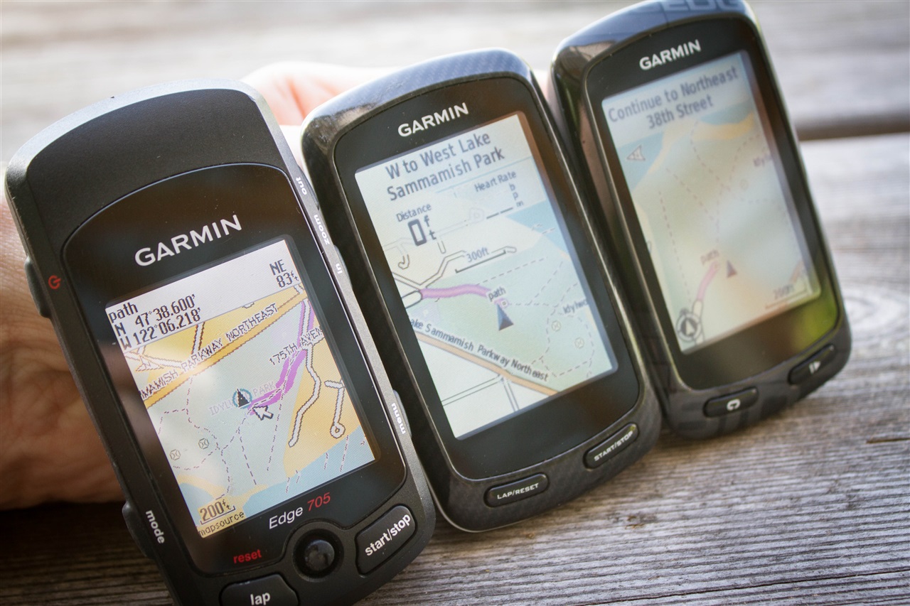
To demonstrate this, you can see how I can search for various nearby eateries and find results:


And then you’ll see how it provides routable directions on streets or even paths in this case. For each step along the way it’ll provide ‘Turn left on Maple Street’ type directions:


You can of course always enter in a specific address or other destination, and it’ll route to that. And if you simply have created a course online (you can do that free on Garmin Connect and transfer it to your Edge), then it’ll provide the map information for that course as it routes.
With that, you’re ready to roll (quite literally). Go forth and enjoy!
As always, thanks for reading!
FOUND THIS POST USEFUL? SUPPORT THE SITE!
Hopefully, you found this post useful. The website is really a labor of love, so please consider becoming a DC RAINMAKER Supporter. This gets you an ad-free experience, and access to our (mostly) bi-monthly behind-the-scenes video series of “Shed Talkin’”.
Support DCRainMaker - Shop on Amazon
Otherwise, perhaps consider using the below link if shopping on Amazon. As an Amazon Associate, I earn from qualifying purchases. It doesn’t cost you anything extra, but your purchases help support this website a lot. It could simply be buying toilet paper, or this pizza oven we use and love.


I came acrosss the site link to raumbezug.eu a few years ago. They also produce free maps based on OpenStreetMap. They have the files rebuild by country it might be easier to get the maps from here (replacing the Part I of the article). The install procedure is the same.
i tried using raumbezug as I could not open the maps on OSM (I have an iMac using Max OS X 10.6.8 v1.1); i have the same problem with these maps – it says I have ‘no mountable file systems’. what does this mean??
I am very dissapointed. Your write ups are usually very detailed. This one is very vague and poor. The part that you call easy is not easy. Your instructions that you simply rename the folder and copy are piss poor. Why don’t you actually explain how you do that. You literally showed the dimensions of every garmin side by side at every angle the fact that you would choose to leave out so many details is shocking. I have got the email and downloaded the link to osm2.pleiades.uni-wuppertal.de. I cant figure out how to open the damn thing and how to get it on my sd card. Instead of saying how it easy is and you just “copy” it why dont you actually try explaining it and show the screen shots. Then it would a useful tutuorial.
Hi Eric-
I’m sorry that thousands of others haven’t had a problem with the piss-poor instructions that save folks hundreds of dollars on maps.
To right click a folder, you simply right click it and click ‘Rename’. To copy, you right click and select copy. To open a Zip file you simply double-click it, like any other file on your computer. In this day and age, those are kinda computing basics.
Sorry.
Thank you for your precious instructions. I got the ZIP file openfietsmap_lite_gmapsupp.zip ok. Then I double click and I see on my screen gmapsupp.img. But when I double click on this, I am beeing offered to burn it to either disk F or G !!!. Since it makes no sense (and no action can actually happen). When I then copy gmapsupp.img to the SD card and activate it from my 800, the map screen remain blank. I have the strange feeling this is not unzipped. Please help. Thanks. Benoit
After you’ve copied the .IMG file itself to the /Garmin folder within the SD card (be sure it’s in teh folder, and not at the top level), validate you see the file there with that name. Then, look in the maps option on the Edge 800 and see if a map is listed there.
Thank you for your prompt answer. I did exactly that and yet the mad that is activable from the SD card in the map sub menu of setup is blank. I have the strange feeling this is still unziped even though I did do the double click unziping procedure. But when I did it windows prompted a “disk burn” message offering to burn into a DVD drive. makes no sense to me. Have you seen this before ? Any advise ?
the message on my 800 inside the “i” from that map is : CMAP data ? OPENSTREETMAP.ORG MAP LAYOUT ? OPENFIETSMAP.NL
Hmm, I’m honestly not sure there. Perhaps someone else has a better idea. Sorry!
How rude!! Chill out man.
that was for eric
The extension .img is used for a lot of different file formats. Windows assumes this is a CD or DVD disc image that can be burned onto a physical disc (like an ISO file if you’ve heard of those). You shouldn’t need to double-click the .img file inside the ZIP, just drag it out of the ZIP window and into the Garmin folder on your SD card. Also, make sure your micro SD card is formatted as FAT or FAT32 and not NTFS. Most cards 32GB or smaller should be fine straight out of the box.
Thank you Gerard, very useful and clear comment. I did all that (also reformatd SD card) and failed again. Map page remains blank when I activate the new map on SD card. Maybe the file I received is corrupted. I shall now request a new one. In any case, thank you again for your support.
Once again thank you Gerard. Your comments were the most useful. I have made a fresh request for a new map and followed your path (not trying to unzip) and it worked perfectly. Now there is also the possibility that something was wrong with the initial file. its size was only 15k where the second requested is 95k for the same region (unless I made a mistake of course). Anyway, ready to ride.
On your side here DC! Your instructions are perfectly sufficient for anyone with a reasonable knowledge of computers. You’re not running an IT for beginners course! Thank you for your write up, just waiting for my map to be built now.
Do you have to unzip the folder first? I unzipped it and put .img in a Garmin folder on my SD card and I don’t see it in the map information. I’m using a Garmin Edge 800
Wait…….so you are complaining that the FREE information provided here is not to YOUR liking because YOU dont understand how to use a computer?? Seriously?? Give me a break man! The information posted here is incredibly valuable to me and I am sure 1000’s of others. Where do you get off posting something like that?
Sometimes I just dont get people……….
“vague and poor”???? I don’t think so. This was awesome. Took me less than 10 minutes to get the maps to my Garmin 800. Thanks so much!!!
Ray-I downloaded image file for where I live on garmin edge 800 and it works great- traveling to another area so I requested map for that area-in moving the image do I replace existing one or place a second disk image in the garmin folder- I’d. Like to keep both on device and add new areas as well- pete
As technology changes and times turn one thing that remains constant is an idiot 100 years ago is no different than an idiot today. Eric Scharlow, instead of wasting virtual real estate and attacking someone who has been a tremendous help, why not do something productive and actually try helping yourself? There is this wondering thing called Google, you should give it a try sometime.
Anyways, this is beyond a helpful guide and literally just saved me $100. Thank you!
Thank you Gerard for your advice to format SD card. I spent a lot of time (several days) “to call into being” LATVIA map, downloaded from OSM, in my Edge 800 but unsuccessfully. As soon as I read out your advice I re formatted SD card at FAT 32 (card capacity 32 GB) and reloaded once more. Now it works.
However I should acknowledge the downloaded LATVIA map is of very old version (very scanty of objects and roads). So such a map is of little use. After that I bought LATVIA map here in Riga maps shop “Jana seta”. This is excellent (very plenty of paths, roads, dwelling houses with their names and so on). I’m ready to pay but I must get guaranteed quality product. Please (it regards all Garmin Edge maps users (cyclists) from other Europa’s countries) let me know ( gunars.silins@gmail.com ): what about maps (downloaded from OSM) quality of your countries? Where do I can buy (get) quality maps of Europa countries? Thank you to all for advice. Gunars, LATVIA
I’d recommend Velomaps. Their maps are updated weekly .
Some maps are free, some require an annual donation allowing regular downloads of the updated versions.
Special ‘mtb’ versions are available for mountainbikers.
Have a look at all the information on their site link to velomap.org
Be sure to read the Beginners Starting Guide in the Tutorials section.
Sometimes of course, the lack of detail on any map may be due to the information not being on the OSM database. The answer to that is to become a map contributor – have a look at link to openstreetmap.org and find out more about it.
Eric, you are a dick. This guy is trying to help people, at no profit to himself and you, due to your own (computer) ignorance cannot follow along so you lash out at him. Wow!
The failure of the Mac to open these files comes about because Garmin use the same file extension .img for their map files as Apple does for disk images that can be opened by Disk Utility. If you simply click on a file with the extension .img the Mac will try to open it with Disk Utility which does not understand the Garmin files.
Don’t worry about this, Garmin GPS units and their software Base Camp does understand these files. I got caught be this first time round as well!
Get an Ipad, PC are not for you.
Create or rename a folder are the most basic steps, my 67 year old mother can do that
Eric, I have to disagree. The instructions are clear and precise. I got the maps to work first time on my 810. Thanks great article. Also saved me money since the maps are free.
Works great on my new 520! Thanks a lot, Ray, for putting this together! Mighty decent of ya.
Hi Rainmaker, Thanks for the instructions/guide on the mapping thing, I am in the Netherlands and tried to use your process for the Zuid and North Holland provinces (several blocks). The Website indeed created the map and I managed to download and put it on my micro SD card on the E800 (using Finder MAC OSX) while I had Basecamp open and watching it for the change.
All seemed to go well, but when I loaded the map, the top half seemed to be completely missing (hashed out). I retried to transfers but got the same result. I have just loaded another map to see if I get the same problem. Do you know if I need to do something to avoid this or when this might happen? Any words of wisdom would be highly appreciated. Thank you! Also for this excellent guide… Very good, would be lost without it….
IThink your instruction was very good my device is working now for the first time .I have manage to improve 9 segments today .
Rainmaker you rock and i have just followed what you said , it is a matter of reading.
jeez, you’d swear you were PAYING for this excellent free advice.
Go figure it out on your own and come back in a few years when you’ve got that done….
The appreciation I have for your answer is beyond words.
Having just received the 520 your reviews and instructions were invaluable and very much appreciated. As are the many detailed reviews you’ve done. One might say that if you were to add more detail to your reviews, that could be excessive. One thing I’ve noticed with the map feature is that while you may zoom +/- you can’t scroll away from your fixed position to try and locate a detailed route off screen. A small quibble (and not with your review). Thanks again for your help.
Your instructions are pretty detailed and worked well for me. A small change on the http://garmin.openstreetmap.nl website, is that you don’t need to enter an email. A directory browser pops up with the files you need.
Thanks again for your valuable insights!
J.G.
Thanks DC Rainmaker. I’ve used your method a few times over the years, in fact every time I go on abroad. I simply get the region i’m visiting and enjoy confident ride’s into the wilderness where ever i go!
I’m no computer whizz and find your instructions very easy…. as long as you have a little common sense!
Thanks again.
I’m also unhappy. At no point in your instructions did you tell me I had to breathe while carrying out the actions. Hence I only got as far as step two before keeling over and fainting. Had you made the instructions less detailed I may have got to the end before collapsing from oxygen starvation. As it is now I can only ride to the corner shop and back, a route I am already familiar with. I will never ever ever use your money saving free advice ever again.
Well done Ray. I am an ardent reader of your reviews. I can’t believe that there are such born-with-a-silver-spoon-in-mouth criticizing about your volunteerism. Your explanations are pretty clear and neat to me. Those who don’t want to exit their intellectual comfort zone just have to $$$$ for it. Thanks again for your work. I am about to acquire an Edge 1000 and was looking for a way to recover my already owned maps. You just answered my interrogations.
Cordially,
Louis QC Canada
Seriously Eric??? His direction are great, this is about the GPS not basic computing. I suggest looking up some computing 101 classes. In this day and age you really need to know how to rename and move files on a computer.
It’s not fair to criticize someone’s tutorial because you’re lacking some skills.
Hello Eric,
To be quite honest, I have never come across such an arrogant tw#t as you sound. Do you actually know how to power on a PC and a Garmin device?? DC puts so much effort and time into his blogs and testing and then you get the old keyboard warrior like you complaining that YOUR screen installation is not as exactly as was written. Do us all a favour and put your dummy back in and ask mummy all about the meaning of manners ? ATB Padgie
Its very simple….you dont know what youre doing!!!
Learn the basics of computer first before you download and you get back to us here once more :)
I can’t believe the rudeness of this guy (Eric). Astonishing. I thought he was being ironic at first. For my part – many thanks Ray. Incredibly helpful and thorough.
I can’t believe how rude this guys was to you, and you STILL helped him by explaining the most basic of basic tasks on a computer. I’m not sure if he was trolling you, or a complete imbecile. Either way – kudos to you for answering.
Thanks for the GREAT instructions!
Heads up people,
I just went through this process last night. Grabbed the micro SD card out of my old phone (new phone does NOT have a slot) and ended up here down in the comments to figure out why it was not working in my two year old Garmin 810.
That SD card is a 128 GB card. No joy.
Luckily I had another 8 GB micro SD card. Worked perfectly.
When I bought the 810 I seem to remember that the max size card it will recognize is 32 GB.
Regardless, I downloaded most of New England, and the areas around Asheville, NC. The file for all that? 323 MB. I’m guessing I can fit pretty much everything east of the Mississippi, if not the whole of the U.S. France and Spain on 8 GB. If not I am sure the 32 would do.
Good luck!
I have an Edge 800, and I do have the entire USA (well, the 48 contiguous states to be accurate) on my Micro SD card. The card is 16GB, and shows 4.0GB used, 10.8GB free space. So adding Europe should be possible….
Really? This free site provides invaluable information. I would suggest requesting the help you need without editorializing and name-calling. It makes you sound immature and ungrateful, neither of which are attractive qualities.
Exactly! What a terrible site!
Do you have to unzip the folder first? I unzipped it and put .img in a Garmin folder on my SD card and I don’t see it in the map information. I’m using a Garmin Edge 800
I have the same problem . Please you kindly advise. Many thanks in advance
There’s no need to be sorry. I’ve been using your maps for years. Found them faultless. Used them in the French Alps, Bulgarian forests, and the back streets of Liverpool and Manchester. Had all 3 countries on an SD Card with no problems. The only problem is my fitness !
Excellent picture of Sefton Park. :)
That is horrible! Sorry to hear this Eric! I hope you’ll get a full refund!
Raimbezug doesn’t let you create your own territory. Netherlads is already too big for my edge 520. Without being able to create my own map, the device becomes much less usable.
Have you tried http://velomap.org and link to openmtbmap.org ? I have used these maps for the two latest years, and I’m really impressed by the quality of the maps – and also the web site(s).
Very nice write-up, very useful for many.
I have never tried the Openfietsmap Lite, only the full one, on this website you can download the pre-compiled files (link to openfietsmap.nl). There is also a hiking layer for people who would like to walk with their GPS.
In combination with the free to download Garmin Basecamp you can make nice routes (use automobile autorouting, trust me this works best, as highways are forbidden) on your PC and transfer those to your garmin GPS. I’ve been using this for the last 3 years. The good thing is that these maps also have a DEM (digital elevation map) which enables to calculate the altitude profile of the route on forehand on the pc (or in GPS with the 62s, I do not know for the higher edge series).
The full version does not contain DEM data, only contour lines. It’s possible to calculate an altitude profile on your pc but not on the GPS (for this you need a Garmin topo map with DEM data, like the recreational map Europe that is included in the T versions of the Garmin units)
Thank you, Ray! Great explanation as usual. I have followed your steps and added a second map to my Garmin 810. I also have the Garmin North America map that I paid for. Since I am new to the 810, I am hoping you (or someone) can tell me if having two maps for the same area will be confusing to the unit and could cause issues. While they are both “active” on my device, I am wondering how I know which one is being used predominantly. If I have the North American maps from Garmin, do I even need the Open Streetmap version?
For as much information as I can find about the ability to have more than one map on the 810, I can unable to determine how multiple maps work on the device and what I need to know to take advantage of both of them.
You can turn off and on maps individually, I always leave the basemap switched on. This is necessary for zooming out. Then switch on the map you want to leave on for that moment. Most likely you can also rename the gmapsupp.img filename to CN-USA.img and Bikemap.img (this is for the garmin 62s), if that does not work name name one map gmapsupp.img and the other gmapsup1.img (this is the method for Nuvi devices).
Thank you, RV. To you or anyone else, is there any point in having the Open Streetmaps and the Garmin North American maps together on the same device if the Open Streetmaps cover the same region? Do the Open Streetmaps provide better accuracy in general? I may just remove it and trust I understand the process of adding others.
I find that if i have both the Garmin map and the Openstreet map enabled, my Edge 800 uses the Garmin one.
I switch back and fourth between the Garmin map and the openstreetmap. The Garmin map is less busy and more readable in dense urban areas. Off road, the openstreetmap is by far the best for trails. In rural areas both are fine.
Thanks Ray for posting this nice tutorial!
Happy cycling,
Minko (designer of the openfietsmap)
Thanks for the work in making the maps
Thanks very much Ray! I bet this post will become a top hit in google soon.
Question: what are the resolution (amount of details) and accuracy (difference from reality) of these maps? How are they obtained? Cartography is a tricky business, are we sure these maps are good and reliable?
Alberto,
I’m a longtime openstreetmap user and a small contributor. The accuracy of the maps depends on the region, but is getting better every day. And I confirm that for certain parts it is even more detailed, and updated a lot faster then commercial maps.
As a user the only ‘problem’ I’ve had is that not all trails are on the map. Since I love walking and trail running, I’m talking mostly about really small trails lost in a forest. Most of the normal ways and roads are on the map. at least where I used it (mostly Belgium).
But that is also easy to fix (hence the contributor part) and if you don’t want to update the maps yourself it is also possible to just upload your gps traces, or log bugs on the map so that the other contributors can update the map.
regards
hans
From my experience most roads are accurate. Still need to be careful when your garmin says you are off course but only cause the road on the map is not really following the road in reality. Happened over the weekend, now to figure out if its already been fixed, if my GPS recording was correct, or if it needs fixing.
The resolution is excellent.
In my experience (in Australia) the accuracy is slightly better than Google Maps (especially for off-road trails).
The cycling specific maps are quite a bit better than Google Maps because they tend to update quicker. That means when the legal status of a trail changes (eg, are bikes allowed on it or not) Open Street Maps tends to be updated quicker.
(Of course, you’ll need to download the latest version yourself manually, but that is the same in any case).
My problem is that I purchased the Garmin City Nav NT from Garmin. They provided a 2GB card which is almost full. How can I move it to a larger card?
Matt,
I don’t if it’s legal to move the Garmin map from the 2GB micro SD card to a larger-capacity micro SD card even if you have purchased it from Garmin. Garmin has installed an anti-piracy mechanism that prevents the Edge 800 from reading any map that has been moved/copied to a different micro SD card. You will see a “cannot authenticate maps” error message.
There are ways to break this anti-piracy mechanism but i’m not going to describe it here. You can google for it.
I am guessing that this process is probably valid for uploading maps to my Oregon 450. Am I correct?
It should be. I haven’t tried it myself unfortunately.
I’ll make an attempt and report via email.
Yes, it will work fine for the Oregon 450 (or the Etrex 20/30 or Dakota or Montana etc).
The Oregon has 850MB of internal memory, so you can just copy the maps to that. You don’t need a memory card unless you want maps for a large area. Just so long as you copy the img file to a directory named ‘Garmin’ in the internal memory.
Edge 705 units only support the singular gmapsupp.img file. Edge 8×0 units can support multiple img files so they don’t need to be named gmapsupp.img
There are multiple OSM maps that work on the Edge units. While they all use the same base OSM data they do render the maps differently (prioritizing certain streets over others, what details are shown, making the roads look different enough from the purple line garmin drawls the course with to make it easy to follow the line, etc)
Some are just changed around by using a different TYP file:
link to avdweb.nl
Some are more involved then just the TYP file:
link to velomap.org
They have two different map layouts: link to velomap.org
One of these days I’ll figure out which I like more.
Thanks, Ray! Very handy.
Immediately filed a request at OSM. Going to test it on the Edge 705. This is an easy way to pre-setup IMG files for different areas.
In addition to the OSM maps mentioned here, you can get extremely detailed trail maps. In the case of the pacific North West (Washington, Oregon, Idaho, British Columbia), there is a great set of free maps available at http://switchbacks.com. Amazingly detailed trail maps of pretty much every trail in the region, big or small, paved or dirt. They will overlay on top of any other maps you have but are not route-able. Even better, if you come across a trail that isn’t listed, ride the trail and send them the track. They’ll add it into the next update.
Haha, you must be sending a huge amount of traffic to them because there are 88 requests and an 8.8 hour queue right now. Last time I pulled a test map from them it was like 20 minutes for the same map (lost the file somewhere).
Thanks for the guide.
Any key differences between the free maps and the Garmin ones? More info, better graphics, up to date, etc? What about a side by side comparison shot between the two?
Short answer, garmins will be more consistent quality for all areas of the map while OSM can be much better for some and worse for others
The free ones are mostly all based on OSM (see my comment a few up from here) As to the differences between OSM and Garmin. OSM depends on volunteers to make, fix and update the maps. So if you bike in an area with OSM contributors then the maps will be very good and will have updates as soon as a change happens but there is also the chance that OSM volunteers don’t care about a certain area.
Garmin makes a commercial map so when that data is being compiled they mostly don’t play favorites so all areas get the same treatment so everything will be covered and updates take longer.
Yup, I’d agree with exactly what Eli says.
I actually took some comparative shots in my Edge 810 review (I think) showing the exact same spot on the different map-sets. I’ll try and dig up those shots today and add them to this post to see.
Thanks Eli and Ray! Yes, if you had a shot of an OSM and Garmin Map of the same location, it would be great! It would be good to know which is more pleasing to my eye!
The OSM maps do have a lot of details that are not in any of the Garmin maps, eg footpaths, cycleways etc. So they can be very useful for walking and off-road cycling.
OSM maps are available in a variety of styles. Some use the standard Garmin style, so look much the same as Garmin maps, others are designed with better colours and icons, to highlight particular things. eg the Openfietsmap highlights cycle routes. Though it does depend on what Garmin device you are using, some maps may look better than others. Its worth trying a few different OSM maps, to see what you prefer.
I primarily use my Garmin Edge 800 in around the Seattle area so i’ll just comment on my experience with the Garmin maps versus the ones from OSM.
The Garmin map that came with my Edge 800 bundle is version CN North America NT 2012.20. It does a pretty decent job on routing on city streets. However, for whatever reason, a huge portion of the well-known Burke Gilman Trail (a paved multi-use trail) is missing. Also, it has no information on the newer Centennial Trial. For the portion of BGT it is aware of, it would does route you to use it.
For the OSM created using Ray’s suggested option Routable Bicycle (Openfietsmap Lite), both the Burke Gilman Trail and the Centennial Trail show up. Even though this is supposed to create a more cyclist-friendly map, no matter what i do, the Edge 800 just refuses to route me onto bike trails. Instead, it would put me on city streets even though the bike trail is close to them.
Just like the map created using the Openfietsmap Lite option, the OSM created using the Generic Routable option included the BGT and Centennial Trail. My Edge 800, however, is able to route me onto bike trails most of the time.
Hi, Excellent write-up re loading maps plus lots of very useful additional comment. I use Velomaps and find them excellent for my area of New Zealand but I agree that quality depends on how active OSM contributors are in any particular area.
This Geofabrik Tools site will give you an instant comparison between different maps link to tools.geofabrik.de
In the ‘Switch tool’ box at top right select ‘Map Compare’. The number of different maps displayed is selected at bottom right of screen and the ‘Choose map type’ allows to select different maps for comparison.
I would encourage users to become OSM contributors – it is easy, fun and helps ensure that all these free maps are as accurate and up-to-date as possible. Have look here link to openstreetmap.org
I have the 705 and spent a weekend recently trying to get open maps on my device until I saw this site. Very grateful for that and now the open maps are installed.
I purchased the Garmin maps some 4 years ago with my unit but Garmin will not upgrade the card, only sell a new one and for Australia they are somewhere in the order of $185. Not only that, due to the ever expanding urban sprawl, a lot of new suburbs with streets are not on the maps but, they are with the Opensteet maps.
So, in short it was worth the trouble. DC’s tutorial was inspirational and informative but, after all that I see Garmin has an 800 at an unbelievable price, unfortunately, for US and Canada only (groan).
DC, thank you for your writings.
You can do OSM maps on the Fenix too
link to gmaptool.eu
Thanks Ray, this is exactly my next task as I go from rehabilitating my shoulder on the trainer to riding outdoors again. I thought readers may be interested in a simple batch file for windows that I’ve written and published which allows for backing up data (in particular, the FIT files) so that we’re not all getting locked into Garmin Connect which doesn’t have a bulk export facility. Hope you don’t mind me plugging my article :) link to teambobbydazzlers.com
I should add, you’re welcome to improve or publish the batch file script on dcrainmaker too, if you think it’d benefit others :)
Nice stuff Tom! I’ve added it to my list of things to chew on a bit (as in, figure out where to add it to a post/etc…). Cool stuff!
Thanks, Ray. I have no preference either way with regard to how they look, but I can say the OpenStreet maps are MUCH, MUCH more accurate than the 2 year old map I had in the Garmin Edge 800 (for a fast-growing area of Canberra, Australia).
I am about to purchase the Edge 810. Is there any reason to purchase the bundle for $200 more that has City Navigator on an SD card? I already have the HR strap and speed/cadence sensor. If I get the package with City Navigator, can I add the free maps to the same sd card? Do the two play well together?
On my Edge 800, i can enable multiple maps at the same time but if the Garmin City Navigator map is also enabled, it will take precedence over other maps. The SD card that came with the Edge 800 is 2 GB. It only had a few hundred MB of free space available. To give you an example of the size of an OSM. An OSM including the whole state of Washington, plus portions of Oregon and British Columbia is about 160 MB. Personally, i don’t think it’s necessary to pay $200 more for the City Navigator map since the free OSM is quite good.
That said, with maps created using garmin.openstreetmap.nl, i do have problems with the turn-by-turn directions on some pre-defined courses (uploaded to the Garmin as a TCX file) if the starting and end points are the same or very close to one another. Instead of giving me the actual turn-by-turn directions for the entire course, my Edge 800 would produce the directions to get to the end point, not realizing that i have not actually started. The Garmin City Navigator map seems to be better in this regard. This problem does not happen to all the courses with the same starting/end points so at this moment i’m at loss as to why it works for some courses but not others. My solution for problematic courses is to move the end point further away from the starting point.
Thanks for the insight. I think I’ll go for the cheaper version!
I tried this on the 705 (version 3.3) and followed the steps to ensure map was enabled (Edge 705: Menu > Settings > Map > Next to “Openfietsmap Lite” select the checkbox under ‘Show’). I don’t see the “Openfietsmap Lite”. In the Map box, it is blank (file shows up on the SD card when I plug the unit into my PC). I still have the ‘etch-a-sketch’ map when I use the 705. Any ideas?
Look for gmapsupp.img.
Whoops. Cancel that last comment.
I have the same problem with my garmin edge 705, have u allready find a why to activate the map ?
Is there any reason one wouldn’t just make one giant map file of anywhere one was likely to ride? I live in Rhode Island, so when I made my request I selected from Eastern New York and all of New England. Is there some downside to this that I’m missing?
Could one choose say, the entire eastern seaboard?
You could, but the resulting .img file may not fit on your GPS.
That’s down to the size of the SD card, correct?
I’m new to the Edge (haven’t even received it yet) but Ray’s directions imply you leave the SD card in place.
Yes. Limited by the 800’s SD card size, which I believe is limited to a standard speed 32GB, but mine card is smaller.
@Changren Yong: To route onto bike trails, make sure you have NOT selected highway avoidance, because cycleways are the main highways on my map. To force navigation on bike routes, select toll road avoidance
Thanks, removing highway avoidance did the trick.
Any recommendations on exactly how to config the Edge 800 to route best using the Openfietsmap Lite maps? e.g. I’ve found items like don’t avoid highways as the cycle routes are the highways, toll roads on or off do something else, carpool lanes on or off indicate special routing, etc. ???
e.g. does this look correct? Comments? esp on the Toll Roads setting. Thx.
——–
Routing on a Garmin Edge 800 GPS using Openfietsmap Lite from link to garmin.openstreetmap.nl for a road bike;
Summarized from link to mijndev.openstreetmap.nl
Menu > Wrench > System > Map > Map Information Select Map > Openfietsmap Lite (Enabled) Basemap (Enabled) City Navigator (Disabled)
Menu > Wrench > Routing > Calculate Routes for = Bicycle
Guidance Method = On Road for Time
Lock on Road = No
Aviodance Setup Toll Roads, U-Turns…
U-Turns = Do Not Avoid
Toll Roads = Do Not Avoid (avoidance will route on bike routes only (“NOT available in the cycling activitiy modes!”), but this last point confuses me)
Highways = Do Not Avoid (cycleroutes and cycleways are the main highways)
Unpaved Roads = Avoid (no routing on tracks, steps and unpaved (foot) paths, except gravel bike path. Also roads paved with cobblestones are avoided.)
Carpool Lanes = Avoid (avoids unpaved roads, footways and steps)
Recalucate = Prompted
Not sure if the Edge 800 already has the latest “active routing” navgation that is implemented in Basecamp.
If that is the case, you better use Car Navigation instead of bicycle. If you have an older firmware or older models like the Etrex 700 series or the old Etrex, you can use bicycle.
Guidance Method = On Road for Time – will prefer bicycle routes, distance will seek the shortest route
Lock on Road = No
Aviodance Setup Toll Roads, U-Turns…
U-Turns = Do Not Avoid – Avoid if you want to continue and not turn back
Toll Roads = Do Not Avoid (avoidance will route on bike routes only (“NOT available in the cycling activitiy modes!”), but this last point confuses me)
This means you have the latest “active routing”; In this case toll road avoidance is only available in the car or motorcycle navigation. Garmin doesn’t understand I’m misusing this feature and deleted this option in their latest firmwares :( They also made carpool avoidance default in all bicycle profiles, which means unpaved roads are often avoided, see below.
You can use motorcycle profile for instance to use a nice route with detours over bicycle routes, and car profile for more direct routes.
Highways = Do Not Avoid (cycleroutes and cycleways are the main highways)
Unpaved Roads = Avoid (no routing on tracks, steps and unpaved (foot) paths, except gravel bike path. Also roads paved with cobblestones are avoided.) – MTB’s should not use this option obviously ;-)
Carpool Lanes = Avoid (avoids unpaved roads, footways and steps) – same as above, recommended for a racing biker to have this selected
Regarding the availability of “active routing” on the Edge 800… I checked with Garmin Product Support and received the following response;
‘Thank you for contacting Garmin International.
The routing programming that is in the Edge 800, will not be the same as what is used in BaseCamp. You will see a closer resemblance of routing between Garmin Connect, and the Edge 800. This is due to these products being a fitness specific area. While BaseCamp is designed for our outdoor products. If you have any further questions, please contact us.
Thank you for choosing Garmin.’
I just purchased a Garmin Edge 810. Do you know the preferred routing setting for that model GPS?
Ray,
I downloaded the openstreet map to my garmin and it is there but when I put in quite a few addresses it says calculating for a while and then says no routes available. Also a lot of addresses of pretty main streets are not there when I do intersections. When I have my garmin on and riding those street names are showing on the map. Any ideas
Thanks
Ray, thanks for the nice article. The quality of OSM data really depends if we have contributors that are interested in the area in question. In places that nobody cares about you wont see the incredible level of detail that we have in our core areas..
To all: we have recently launched both a simplified way to report issues with the data link to blog.openstreetmap.org and a HTML5 based “beginners” editor: link to blog.openstreetmap.org
Please if you notice an issue report it it via the “notes” function or, even better, fix the problem itself. If you don’t jump in at the deep end, adding to OSM data is easy and you can gradualy progress to more difficult things with time.
Simon
PS: it is OpenStreetMap (no “s” :-))
Thanks Simon! I have started to update incorrect datas on OSM that i discovered on my long weekend rides and have been busy adding/updating the maps in my neighborhood. I really like using OSM because if something is missing or incorrect, i can always correct it myself, unlike Garmin’s City Navigator (the latest version is still missing some important local paved bike trails).
I followed your instructions and successfully downloaded the map to the SD card on my Garmin 800. the Garmin does not recognize the files on the SD card. the maps on the SD card do not show up in Maps section. the How do I enable the maps?
I enjoy your reviews and travel pics.
george
You don’t see any maps? At the minimal, you should see the base map (this map is actually stored within the Edge 800, not the micro SD card). Is the SD card that one that came with your Garmin? If it is, you may have accidentally overwritten Garmin’s City Navigator map because that file is also named gmapsupp.img. That may explain why you can’t see the map you downloaded on the phone. Why don’t you try renaming it from gmapsupp.img to something else, like omapsupp.img. When i was using Garmin’s micro SD card (which contained City Navigator), i would rename the OSM maps to something other than gmapsupp.img so that i could choose which map to enable.
Thanks for the help Changren,
The base maps are present on the garmin 800. The sd card is blank. The garmin will not create any directories on the sd card when it is installed in the garmin. I can’t get the OSM maps to appear on the device.
Ok, if I’m reading you correctly, I think you did not create a “Garmin” folder on your micro SD card. You need to create this folder in the card while it’s connected to your computer. Then transfer the gmapsupp.img to that folder.
George/Changren, I’m experiencing this same issue of not being able to see the file on my edge, did you find a solution? I downloaded, unzipped, created Garmin file, then copied the img file to the folder. Placed it in the edge 810 and don’t see the file. Tried reformatting card to Fat, recopy. Same, I can’t see the file when going through the menus on the edge. I also tried to copy the file to my old garmin street map card to see if it was the card, same, still don’t see it. Any suggestions would be appreciated.
Hi Ray, thanks for this info. I am downloading Italy for a trip there in a few weeks. I followed your instructions but when I tried to unzip the file called openfietsmap_lite_gmapsupp.zip, it produced a file that was about 88.6MB (which seems about right) called openfietsmap_lite_gmapsupp.zip.part. So, my simple question is how do I get to an image file from that. The zip also created another file called openfietsmap_lite_gmapsupp.zip.cpgz which is about 268 bytes. I would appreciate your guidance. Thanks so much, Dan
Your download most likely did not complete. I would suggest downloading again.
thx. that worked!
I am headed on a trip to the Provence and Burgundy regions of France and want to know if the OpenStreet maps are adequate for navigation or whether I should use the Garmin maps on my Edge 800. I have used the OpenStreet maps in the US and they are fine for me but just want to ck in before starting a trip.
Thanks!!!
I’m new to the Edge GPSs. In the past I have used a Nuvi for both car and bike but the newer Nuvi changes routes without announcing it even when I am not off course [No option to prevent recalculation]. Following the excellent directions I was able to download and install OSM maps. I then tried to create a track using BaseCamp (with the Garmin maps). I put it in the appropriate directory and was able to select it under courses. It displays properly on the Edge 800 but does not give me directions as I follow it. Is this what is meant by “active routing” above? Is there something wrong with my configuration or should I have created the track specifying motorcyle? I didn’t understand the comments in #51.
Are these free maps topo and do they typically have State and Natl Forest trails marked (for Mtn biking)? Thanks for all the info!
Tried to download on a Mac and I don’t get a Zip file – I get a file with the extension .img that I can’t open. Any suggestions?
Is it gmapsupp.img? If so, that is your map.
Your Mac most likely unzipped it for you automatically. If that’s the case, the file with the .img extension is not the same type of file as a disk image on a Mac. Just transfer the file to the “Garmin” folder on the micro SD card and you are good to go.
Hello, great review, just what I was looking for before buying an Edge 810. So I did and it arrived a couple of days ago. However I have been trying to put maps on it unsuccessfully for the same past days (everything else works fine). Here is my situation in hopes that someone might be able to solve it:
I downloaded and installed two maps from garmin.openstreetmap.nl
I then renamed both the maps using JaVaWa GMTK
The maps show up correctly in BootCamp and I can seitch between them using the drop down menu
I then transfered the files to the memory card in the Edge using the “Send map to device (or something like that)” function. This took a long time, almost an hour.
I have a 64 GB micro SD card where I have put the maps.
When I go to: “navigation > map >map information select map” I only see the “INTL Standard Basemap, NR” enabled. There are no other maps on the list.
I have also tried to transfer a BirdsEye demo map to the device (not to the memory card, but to the internal storage) and this doesn’t show up either.
When I access the memory card I can see a couple of .img files in a folder named “Garmin”
Would appreciate any help as I am getting quite frustrated since I bought this mainly for the routing features.
I have now successfully loaded a map, this time I put it on the internal memory and it worked. It doesn’t solve my problem however as I need to put the map on a micro SD card.
Could it be that my 64 GB card is not supported?
According to Garmin, the largest micro SD card supported is 32GB:
link to support.garmin.com
From the Garmin site;
What is the largest size microSD card I can use with my Edge 810, 800, 705 and 605?
The Edge 810, 800, 705 and 605 have an expandable memory slot into which a microSD* card can be inserted. This card provides the ability to install detailed mapping to enhance the device’s internal basemap.
It is recommended a standard speed card, no larger than 32 GB, be used in order to get the best performance from the device. Class 4 to Class 10 is considered standard speed.
A couple of pointers:
– general OSM related questions can be asked on help.openstreetmap.org (please search for an answer first)
– coverage: I would recommend checking the map on http://www.openstreetmap.org (note: the default map is designed to give mappers fast feedback on their contributions, not to look good), if you are expecting lots of trails and tracks and don’t see any, then you might have to consider using something else. However in most of western Europe the coverage is very good.
Besides use on Garmin devices there is a OSM plugin for SportTracks, Garmin Connect offers it as an alternative map source and there are a number of (non-sports) navigation apps for Android and iOS based devices.
I hope this question hasn’t already been asked and answered and my apologies if it has. I can’t see OpenBikeMap as an option to enable. I followed the directions, which as usual were excellent – you can never have too many screen shots for us non-techy types. The gmapsupp, disc image file transferred to the SD and is in a folder Garmin. The SD card is installed in the Garmin slot (BTW, it is a 32 GM Card). The problem is that when I follow Ray’s steps to manually enable the map OpenBikeMap isn’t an option. The only option is the AMR Standard Basemap, NR. Do I need to disable the ANR Standard before the OpenBikeMap option becomes available? Any suggestions would be greatly appreciated. Thank you. Regards, Bruce
How was the micro SD formatted? I have a Mac so the first time i formatted the micro SD card as exFAT, my Edge 800 was not able to read anything off it. After i reformatted it as FAT32, the problem went away.
After downloading the map, I have created a course to follow on my ride using connect.garmin.com. While accessing the course on my Garmin 800, is there a way to still see POI’s, or do I have to exit the course?
I am new to the area I am riding in and want to be able to see if there are any convenience stores that are either on my route ahead or how far off my route they may be.
Thanks for any help.
On the OSM created using Ray’s instructions, i can see icon for gas station if i zoom in on the map to the 300ft level after loading a course. You just have to make sure the Map Detail Level (on Edge 800) is at least at “Less”. If it’s set to “Least”, you won’t see any POI unless the map view level is 120ft.
In comparison, POIs can be seen at the 300ft level using Garmin City Navigator map even when the Map Detail Level is set to “Least”.
Thanks for the great articles.
I got a 810 yesterday for fathers day. I like to do a mix of gravel/ road/ trail on the CX bike, especially in places without cell service. Ideally, I’d like to download a route from map my ride or google earth into the 810, and then get turn by turn directions.
Do you have a article for “your garmin for dummies” that might help me (and others in similar siuations out)?
I think I’ll need to begin by getting a card and downloading these openstreet maps, but I’m not even sure they willinclude the mix of trails?
Thanks,
Wheatthins
Sorta. I put together this ‘So you just gotta Garmin’ post, which sorta consolidates everything: link to dcrainmaker.com
Ray are you aware of any limitations such as “the bigger the card the slower the Edge is at accessing maps off it when it gets close to full?” I am actually asking about the Edge 800 that I got during the Memorial Day sale (thanks for the link to the maps instructions here! I hope this works well on a Mac too). I’d probably look at an 8 Gb or 16 Gb card at most (finding a 4 Gb might be tough nowadays…). Is there a good rule of thumb to estimate the size of a region (e.g. Europe 4 Gb, Western America blah blah)?
I’m not aware of any such issues with sizing.
For reference, this weekend I downloaded all of France + a chunk of Spain + a chunk of UK. All in about maybe 15% of Europe from a land standpoint. It as just under 1GB.
Thanks Ray. And all classes (4 to 10) are equally as good in the Edge? I don’t care that much about transfer time to the card that much… I figure that’s the small part of the time it takes to get maps, even though I plan to download my routes from the RideWithGPS site too. I care about how fast the Edge needs to/can read the data.
Hmm, I haven’t tested to check any differences there, but I can’t imagine it would make any difference to the Edge, as it wouldn’t come anywhere near those speeds.
Transferring data directly to the Edge 800 (i assume it’s the same for 810) takes a very long time. It’s significantly faster if you transfer the map to the micro SD card connected directly to your computer.
Coming back to my original question, if I may, please. The SD card shows that maps were successfully downloaded to the card. The card is in my 800. The computer recognizes the card and when I click on the card the maps are in a folder named Garmin. My problem, however, is that when I try to enable the maps, the 800 dorsn’t show the map set. I am sure I missed one of Ray’s excellent steps, but I can’t figure out what it is. Any help would be appreciated. Thank you,
Bruce
See my response to your original question.
See my response to your original question.
Thanks. I missed that response. I did realize the SD card had to be formatted. Does it make a difference that I have a PC? I guess if I format the card I will have to reload the maps. One thing that concerns me do I have the card set up correctly, i.e. the folder or directory that the map file is in. Guess I need to go back and read the directions again. Regards, Bruce
Makes no difference if you have a PC or a Mac. I don’t know how to check the format of the SD card on a PC but on a Mac, you use a program called Disk Utility. In any case, even if you have to reformat it, i don’t think it’s that big of a deal. Just make sure you choose FAT32 when you reformat it. After that create a “garmin” folder (i don’t think the case letter matters) and copy the map to that folder.
On a PC, you can right click the drive (assuming it’s put in an SD card reader) and then click ‘Properties’. It’ll say ‘File System:’ about 1/3rd the way down.
Also as noted above validate that you placed the IMG file, not the .ZIP file into the Garmin folder.
Thank you!!It works………
Hmmm… I call a fail in the Seattle area, and even a bigger fail than Changren Yong reported, at least with the maps in MapSource (activity: Bicycling or Tour Cycling). Look at those screenshots: link to i41.tinypic.com show two routes from Village Wines to the Fremont Troll. The closest one to the Burke Gilman trail is from the routable cycling, the other one is from the generic routing (really bad!). But as link to i44.tinypic.com show, even the less bizarre route goes to length to AVOID the bike trails.
I sent an email to the Openfietsmap guy (girl?) after seeing Changren Yong’s post but haven’t gotten an answer. I’ll be happy to contribute some changes to OSM but am not sure which ones. For now, those maps certainly do not do a good job for bicycling around our trails… If it’s that bad in Basecamp, should I expect even worse on the device which has less CPU to compute the best route?
Did you have avoid highway enabled? If so, that may be the reason Garmin is not routing it on bike trails as Openfietsmap considers bike trails as highway.
We have a fairly active US community see link to openstreetmap.us I’m sure you can find somebody there that will show you the ropes (if necessary).
As I pointed out earlier there are a number of different producers of GARMIN maps from OSM data, typically catering for different audiences both visually and for routing. You should probably give link to openmtbmap.org a try and see if that works better for your use.
Simon
@Changren know it must have been an “avoid highway” thing. While there is no setting for it in Basecamp, if I redo the route using “Drive” as the activity I get a route on the trails. So I am assuming this is indeed what happened there. Great! I just received my micro SD card so I can try now on the Edge 800 itself.
@Simon, thanks for the links. I know about openmtbmap.org (and velomap.org) but like the look of Openfietsmap a lot better than theirs, and wanted a way to get started quickly to try without getting into their premium content buy (I have a Mac).
Is openstreetmap.us a good place to ask about things comparing both (for example it seems that Velomap may have global DEM while Openfietsmap does not in the lite version but I am not sure)?
@Changren do you still see your issue with “routable bicycle” with the latest maps from Openfietsmap? On the desktop at least now that I picked Drive to have highways the trails are hit… I may not be able to get close to the Burke Gilman trail for a while to test with the Edge.
@frenchman I have not had any issue after disabling avoid highway.
Replace MapSource with Basecamp in my previous message… Oops! Sorry!
My computer won’t recognise the SD card. When I put card into Garmin 800 and connect to PC how do I know which file is the DS card to copy maps to?
My computer recognizes the SD card even when it is plugged into the Garmin. My problem is that the device itself doesn’t recognize the SD card. I am going to go back through chain of comments again to see if I can get the problem fixed.
Thanks Rainman! Awesome instructions, easy to follow. I got my Edge 800 yesterday, saw the “map” on it and thought – !@#$%^&* is this?!! Thank you for providing a free solution. Another hundred bucks for a real map would be maddening.
Loved seeing W Lake Sammamish Parkway on the screenshots! (I live nearby/ work in Factoria, proud to have you in the region and hope to run into you on the trail)
(Correction: hope to SEE you on the trail)
Ray, How do you add more than one state or country to the SD chip in the Edge? I downloaded Colorado and once it appeared as a 97.8MB file called “gmapsupp.img” I drug it into my Garmin folder and the maps were enabled on the Edge. But when I tried to add a second set of maps, of France where we’re going this fall, the same file name appeared, this time a 742MB file, which would not load when i drug it to the folder. I tried renaming the file “gmapsupp1.img” and then it would load in the folder but no France maps appear when I go to enable the maps, nor can I find any French locations such as cities etc. when i search. Thx.
You’ll need to use the procedures I outlined within the Edge 810 review (around Basecamp to combine them, applicable to older Edges as well). That said, I thought someone said that you can now put multiple .IMG files named separately onto the Edge 810 with a more recent firmware. I just need to try it out.
I’ve been using OSM maps from talky toaster in the UK and they’re great. I just wish that you could route using addresses and postcodes in navigation but it’s not available.
Help!
downloaded map for trip to europe as i’ve already bought Britain and don’t want to spend the cash for europe now. followed instructions but my map downloaded as folder called OpenfietsmapLite.gmap I was expecting one large image but now have a folder of various things that my Garmin 800 won’t recognise.
It sounds like you downloaded the wrong file. You need to download the file named “openfietsmap_lite_gmapsupp.zip”. Then when you unzip that, it will contain a file named “gmapsupp.img”. So just copy that onto a memory card in the Edge, in a folder named “Garmn”.
Should I opt to include the Mapnik TYP file from the OSM for downloading to my 810?
What difference does it make to the view and to loading times?
Hi
I use Macbook pro and did the above steps.
Downloaded the image file
Transfered it to garmin but it does not show it in the maps
Any one who tried it on MAC OSX plat form?
UPDATE: Solved!
1- On Mac platform when you download the Openfeitsmap.zip file it downloads as “disk image” with extension .img (gmapsupp.img) in your downloads or documents folder (based on ur settings)
2- IMPORTANT: Insert MicroSD card, it will show on you Mac desktop, click it, create a “folder” named “Garmin”
3- Now drag the gmapsupp.img file into the “Garmin” folder in the MicroSD card
4- Eject both Garmin and MicroSD
5- Your maps on!!!
I was simply dragging it on the MICROSD card and it was not showing, you got to create a FOLDER!
Thank YOU Haroon for posting this. It was the most helpful part of this thread for my problem. I am so glad you took the time to post this, I thought I was going mad. The simple solutions are often overlooked and rarely posted, so I thank you for saving my sanity!
Glad it worked!
years later, the simple solution still works!!! Thank you!!!
I’ve hit a bit of a snag while trying to add a second map and am hoping you guys might know what I’m doing wrong. I’m currently getting the error message, “Cannot Authenticate Maps”.
I’m interested in having three maps on my 800 – the AMR Standard base map (on the internal drive), the OEM CN North American NT (gmapsupp.img map 1.4mb), and an added Open file for North America, which I’ve named openmap.img (3.9mb).
I’m using the 16mb card recommended in the article above and had the maps independently working when replaced the default map with the larger Open Map – then named gmapsupp.img. Since trying to run multiple maps, I’m hitting the snag. It appears that when I try to load everything to the SD card, the Garmin will be able to find only the AMR and Open maps – not the OEM “CN America NT”.
Here’s what I currently have on my 16mb SD card when I access it via my computers SD slot (I get a lot more when I plug my Garmin unit it via USB).
/Removable Disk
GARMIN (folder contents listed below)
pmp_usb config file
winamp_metadata dat file
winamp_metadata.idx
/Removable Disk/GARMIN
/Activities (empty folder)
/Courses (empty folder)
/NewFiles (empty folder)
/Workouts (empty folder)
gmapsupp.img (1.4mb default map)
openmap.img (3.9mb Open map I created)
grmn0.gma
Gmapsupp.unl
Any ideas what I’m doing wrong? Does it matter if I load the maps via SD port or via the 800 plugged in?
Thanks,
Matt
Matt S:
I think you got your unit wrong. The Garmin City Navigator map is about 1.4 GB (not MB). I don’t know the legality of moving the Garmin City Navigator map from the micro SD card that it originally came with to another micro SD card with larger capacity. But the reason why you are seeing the “Cannot authenticate map” message is because the Garmin map is hard-coded to that specific micro SD card. When you copy that map file to another micro SD card, your Edge 800 realize the map is not on the correct valid micro SD card. I believe Garmin did this to prevent piracy of its maps but it is a pain in the ass for people who legitimately own it and wants to move it to a micro SD card with larger capacity.
There are ways to get round this but i am not going to post it here. You can google for it.
I’ve ordered an 810 with City Nav Europe and the 1:50 UK Discoverer bundle. (not yet arrived).
Will I be able to load OSM maps also?
Will these have to be put on a separate card (not ideal to have to change cards if you want a different map)?
Can the OSM maps be loaded onto the 810’s card? If so, is there any chance I could overwrite the City Nav EU or 1:50 Discoverer maps by accident??
If not enough space on the 810’s card can I transfer the City Nav EU and 1:50 Discoverer maps onto a larger card and add on the OSM maps to the same card?
You can mix maps, but you’ll need to use the steps outlined within the Edge 810 In-Depth review to dive into how to merge the two.
(Note: It’s possible that the 810 allows manual adding of multiple maps on the unit without software, I just haven’t tested/validated that yet…sorry!).
Hi,
I followed the excellent instructions and successfully installed a map of France. I planned routes at home before the trip and loaded them successfully. After a day the Garmin stopped working…I’m wondering whether it’s possible there was something from OSM which could have corrupted files? Or whether this was just a co-incidence? Anyone else had a similar problem?
I’d guess pure coincidence. If there was an issue, it would be related to loading the map upon startup, not mid-ride.
Great post Ray. Got to France and realised I’d had a Great Britain Discovery map bundled with my 810. Deleted the map file off it and replaced it with one I downloaded after following your instructions. Worked a treat.
Many thanks
Awesome, glad to help! Welcome to France!
Has Garmin Connect essentially replaced Basecamp if you use an 810?
Is “Courses” in Connect the same/better/worse than Basecamp?
I’m going to France for a few days this weekend and wondered how best to plot a route for me to follow….one that avoids the busy main roads and dual carriageways!
Yes and no. It’s complex.
Basecamp is definitely the core product for transferring maps to the unit (as opposed to Garmin Connect, which today can’t transfer maps). It’s also the product if you’re going to do any transferring of complex navigational waypoints – another area that Garmin Connect can’t do.
For me, if it’s just a route, I prefer Garmin Connect – and especially with the Edge 810 because you’d be able to access those and transfer them from the web. Also, snap-to-road functionality is within the site and definitely better there.
I’m trying to get some maps on my new Garmin. I downloaded the .zip file to my mac and it seems to have unzipped it for me, but there is no .img file. There’s a folder called Openfietsmap Lite.gmap containing a subfolder Product1 with yet more folders but no img file at all. Did I miss downloading something? Is there something else I need? I’m running OSM 10.8.4.
Forgot to say it’s an Edge 810.
What is the name of the zip file you downloaded? If you downloaded the one for Mac OSX, that’s not the correct one if you wish to use Ray’s instruction.
I knew Ray’s were for a Windows system so I was trying to use Haroon’s from above. My downloads folder contains no executable files, no .zip file, no .img file. The instructions on the garmin.openstreetmap site are very vague–the zip file is described as an installer nothing installs.
Did you download the file openfietsmap_lite_gmapsupp.zip? It does not matter if you are following Ray’s instructions or Haroon’s, this is the file you should be downloading. Depending on the browser and the setting of in your browser, it may unzip it automatically for you. I’ve configured Safari not to extract/open files automatically after being downloaded so any zipped file will remain compressed in the Download folder. If you situation is similar to mine, then you have to double-click on openfietsmap_lite_gmapsupp.zip to uncompress it. The resulting file should be called gmapsupp.img.
Again, DO NOT download the file from Openfietsmap that says for MAC OSX. This file requires a couple of Garmin apps on the Mac in order to transfer the map to your Edge 810. This process is a lot more complicated than the instructions described in this post.
Thanks, Changren. I’ll try that when I get a chance (which may not be for a week).
Changren – i have the same problem as Jacquie; i have got gmapsupp.img on my Downloads (on an Imac) but i cant open the file – i get the message ‘no mountable file systems’ – whatever that means!! Richard
Richard, you don’t open the gmapsupp.img file on your Mac. It is the file you copy to the “garmin” folder on your micro SD card.
Thank you so much for taking the time to put this post together, I followed your instructions to create a map for my new Garmin Edge 810 (Which I bought without maps having found this post) Even though I build Ecommerce Software for a living, I must say that I was a little bit skeptical that it would all be as easy as to create maps as your instructions made out. None the less, I had a full set of maps for my local area in the UK within an hour (baking time), then went on to make a map which I will be using later on in the year on a cycling holiday to the Canary Islands. Brilliant thanks so much, I sent open street map a donation too, they saved me about £90 GBP! – happy days!
Thanks Changren – but i am still lost! this is all a bit sophisticated for me! i think i have copied it to my Edge – but when i check the maps it does not see it (it only sees the basemap). i have also had no luck trying to copy the City Navigator & GB Discoverer (which i purchased) onto my 16gb card – i gather you cant do this – hence i was trying to download a free map. i think i need to find someone more used to this technology – being in my 60s it is all a bit too up-to-date!! Richard
Richard, did you copy the gmapsupp.img file to the “Garmin” folder on the micro SD card?
just like to say thank you for a great post, my 705 is back in use!
To get the maps to work on a 705
On your card your should have 2 files
GMAPSUPP.UNL
GMAPSUPP.IMG (this is a map I purchased)
I’ve renamed the GMAPSUPP.IMG to GMAPSUPP_UK.IMG and copied the new map file to the card and called it GMAPSUPP.IMG
This shows up in the map settings as described in the tutorial
Once I’m done with the current map I’ll rename the _UK map file back to the original GMAPSUPP.IMG
Love the site, thanks! Two questions (for now). Just got a Garmin 800. If I want to have maps for two areas, say my home base and a vacation map would you just swap out the map file on the Garmin or can one of the maps be renamed as the maps have the same name. Or can you create a map with two separate areas. We vacation in the same spot. Secondly how often do update the map of your home base?
Yes, you could swap out maps (simply have them handy on your computer). Or, you could go ahead and use the site above to build a big custom map set with your vacation spot and your home spot. Then you’d just have one map set.
I don’t often mine that much…mostly because Paris roads don’t change too much these centuries. :)
Struggling to make this happen. My maps have been obtained. I have the gmapssup in a folder and on my desktop as well.
The gmapssup have been transferred to my SD micro card, which has been inserted into my Garmin Edge 800. The Edge does not seem to give the new maps any attention. Any advice or tips? My maps do not even show up under “maps” in the settings tab. I have about 49mb worth of maps, so not to terribly much. I have my area here covered and another frequently visited vacation destination.
Help please!?
Harrison, having the same problem you detailed above, can you tell me your solution?
Wait! I got it :)
Much appreciated for this how-to-guide. Speaking of which, may I ask why it’s not featured in the “How To Guides”?
Glad to hear it’s all sorted out!
It looks like it’s in the How-To section, but within the Sports Technology subcategory: link to dcrainmaker.com
Thank you so much for the info about how to upload the OpenStreet maps…such good advice and so easy to do, thank you.
I am still not 100% sure how to search on location though and ask it to take me to a particular address, as it says that address/city can’t be found – any ideas?
A big thanks to Ray for these great instructions on the map download! I`ve got the Edge 810 now for about a week, and since I got a little bit of time on my hands I started to play around with a lot of different maps to see the differences.
First of course, I followed Rays instructions and downloaded the routable bicycle map from the suggested link. Everything works fine, but the thing that annoyed me (as a hiker AND biker) is, that there are no elevation lines included on these maps. (or did I miss anything?) I don`t know why, but I just love these lines…they let me easily spot a nasty hill in the area to circumvent :-) So, next I downloaded the maps from openfiestmap.nl, and these maps are great – they include elevation lines (I think this is how you call them, right?) and show great detail. However, the routing is not that great when compared with the original Garmin maps (even though mine are from 2009 and have never been updated…for obvious reasons…). In this case, I particularly compared the topo Austria (Garmin) with the Topos from the above mentioned pages.
This is really my only complaint…the routing function (on the GPS device itself) is somehow weird, which I guess has to do with the attribution of certain trails. I don`t know if anyone has made the same observation, but when I use different modes (e.g. Hiking vs. Mountainbiking vs. roadcycling) the device selects sometimes forest trails with roadcycling or roads with the Hiking mode. It works so-lala, but not as good as with the original Garmin maps.
I also downloaded the maps (both, velomap as well as mtbmaps) from openmtbmap.org after donating some money. Here my experience was even worse – the routing function does not differentiate between the various modi at all – even though all these maps are based on the OSM maps. So here goes my confusion.
I now wonder, any suggestions out there in terms of really good, routable maps (for all uses, roadcycling, mountainbiking and hiking) including elevation lines? The openfiestmaps are already pretty good, but not amazing (instead of hiking I have to for instance use the “by foot” mode in order to walk on small trails). Also, very often I am getting routed along main roads instead of cycling tracks which are running parallel.
Any help or suggestion is appreciated.
Niki
is that possible to download the map that i wanted into my garmin fenix? if so, how can i do that ?
Thanks a lot. Very, very helpfull.
Great post! As you say, there’s other ways to get the free maps, but this way is by far the easiest. That said, I’ve also downloaded Mantlik’s maps in order to be able to use the contour lines. I summed it all up in a post with screenshots of what the maps look like here: link to bikingbrian.com
Help! I am new to loading maps on my Garmin 810. I downloaded the map for France onto my Mac and transferred the map gmapsupp.img into new files on my 16 gb micro SD card. The file shows up as being on the card when it is plugged in to my Mac but it does not appear on the Garmin 810 when I unplug from the computer and boot the Garmin. I only see AMR Standard Basemap, NR. What am I doing wrong? Thanks.
You are putting it in the wrong folder on the micro SD card. It should be the “Garmin” folder, not the “new files” folder.
Thanks! Just figured that out.
According to Highly Tuned Athletes owner Mr Rob Grinter all the problems I had with my Garmin Oregon 600 recently occurred because I was using OpenStreetMapping. The maps caused the following problems which I raised with Garmin International (ignored) and Highly Tuned Athletes. Apparently my use of <a href="link to openstreetmap.org was irresponsible and the cause of these issues as it seems it works fine for them at their store … (with those same maps installed BTW). I experienced all of the below whilst riding in the South-west of WA. It seems that the disclaimer at link to garmin.openstreetmap.nl where I download the maps from explains these issues.
I have found Mr Grinter’s comments rather interesting given that these same maps worked fine initially, work fine in my Garmin Edge 810 and seemed to work fine at Highly Tuned Athletes store.
Anyway just putting out there what I experienced and if you have a Garmin product and use Openstreetmaps and experience any issues you might want to remove the maps before returning the unit for investigation.
The following is taken from my letter to Highly Tuned Atheletes.
1. My Garmin Oregon 600 not synchronise with either of my Garmin GSC-10 sensors despite both advertising material and the manual indicating otherwise. Those same GSC-10 sensors synchronise with Garmin Edge 810 and previously with my Garmin Edge 800 so I know the issue is not with the sensor. Interesting the Oregon 600 will synchronise with my Adidas HRM strap. I consider this critical failure as it was one the features I lead to my purchase of the unit. Any replacement or repair must have this functionality working correctly please or there is little point in replacing or repairing the unit.
2. The Oregon 600 has been inconsistent with its auto-pause function. Sometimes it will auto-pause sometimes it will not. The amount of tree coverage appears to have no influence on this. I have found that on more than one day, a day of riding could be recorded with approximately 60% being added to the day’s distance when compared to the map. I didn’t deviate from my planned route at all and hence this sort of error level is extremely concerning, more so if one is navigating and using distances as a critical navigation tool. I found the only solution to this was to physically turn off the unit whenever I stopped.
3. In contrast to the issues raised in dot point 2, I found I could be riding along when the Oregon 600 would simply go into auto-pause mode. This was a known fault in early firmware updates of the Garmin Edge 800 and which was fixed so it is staggering to see it happening again now with a much more modern unit in the Garmin range
4. I found the Oregon 600 showings speeds up to 30 to 40 km/h when I am doing 10 km/h or less and again in situations where often there was little to no tree coverage. On one day it recorded a maximum speed of 90 km/h! I was riding a loaded mountain bike on dirt trails where my average speed would have been around 10 km/h over the day.
5. The Garmin Oregon 600 route tracking gets confused following a turn in the road or trail and often then heads off showing me going well off-track and adding considerable distances to the day’s ride distance.
6. On more than one occasion it would simply just recorded me heading off into the wilds for no apparent reason;
7. My Oregon 600 regularly looses satellites even in clear tree coverage (e.g., riding in farming country). When this occurs I have to use the auto locate satellites feature to re-locate the satellites. When I do this the Oregon 600 finds the satellites within seconds. On some days this was happening up to 15 times over a six to eight hour ride. In my view this is a very serious concern as surly a company such as Garmin Limited with a history of GPS development should have such a fundamental functionality working correctly.
8. If I switch to external power source (e.g., USB battery supply) it causes the Oregon 600’s screen to change to a different display and at times simply changes the chosen the profile! It simply seems to have a mind of its own.
9. I found that a set of Duracell Ultra alkaline batteries I tried (fresh purchase) lasted no more eight hours which is well short of the claimed battery life. I was getting similar battery life times from a rechargeable batteries as well;
10. My Oregon 600 will at least once a day randomly turn off;
11. My Oregon 600 will lock up requiring the removal of the batteries to force it to restart again seemly on a random basis;
12. Tones continue to sound even though they have been turned off in the settings
13. Updating to firmware 2.8 resulted in the lost of the geocaching profile as per our email discussions.
Regards
Andrew
This is excellent!
I have a 800 and travel a lot. I have a mac and just have a folder on my desktop with various maps from around the world. Found that my 800 doesnt like 2 maps at a time so I just delete any off the card Im not using and have them backed up on my desktop folder.
Example: Yesterday was in Thailand so I had the thai maps and nothing else. Today in NYC and have the NYC maps and nothing else. All my maps are on my mac so can delete and add anything to my micro SD card ‘garmin’ folder anytime.
Im pretty computer illiterate but found the support in this thread very helpful. Especially Mr Yong.
Thanks for this great help. On my new Edge 800, I find no problem downloading multiple map files to the SD card. To do this, you have to give each file a different name, but the 800 seems only to use one file named GMAPSUPP to do routing. So I give the files I am not using temporary other names, such as GMAPSITUPP for Italy and rename the file I want to us as GMAPSUPP. This lets me store my files on the SD card in the Garmin, and just takes a minute on a computer to change the map file names when I change locations. This seems easier than creating the “one big map” each time I want to add something, but keeps the files handy and ready to go. Is there an easier way to do this?
Thanks! Worked great!
I had thought it would help the Edge 800 to run faster if I had separate smaller files for each area I wanted to cycle in. I created two small files, renamed them and uploaded them to the SD card. Garmin calls them both Openfietsmap and seems to load them both.
How can I identify them as separate files so I can select them individually? Does it make any difference to the speed of operation?
The name the Garmin displays is from inside the file. It might be possible to change it but not very easily. Anyway, I doubt it matters for speed: the Garmin isn’t doing anything with the name beyond displaying it.
By the way, from my investigation, the “openfiets/bicycling” versions do not produce very good routing if you are in the US. (That is, when you use the Garmin like a car nav unit to compute a route to a destination).
If you use the Garmin to compute routes, you might consider using the normal (non openfiets/bicycling) versions of the OSM and use “avoid highway”.
Hello there,
I am in a bit of a blind panic. I am not the most technical person in the world but I bought an Edge 800 expecting it to have routable maps on it. After forking out a fortune i realised it has none and I am currently t-2 days away from a bike ride from London to Berlin, where we were expecting to load the routes on to the Garmin. A few questions, do I need to have the SD card, can i just download on to my MacBook Pro and then transfer over? I have asked for whole of the UK, parts of Holland and Germany. When do you reckon i can get it all done by.
This was so nice of you to do all this work! I really appreciate it.
Thanks for the info and the tutorial.
Is there any way to put the file on the garmin, not the sdcard?
Thank you
It depends on the device and how much room is available. I put the files directly on the device using a garmin 705 but on the 810 there is no room.
I am one of the guys behind http://ridewithgps.com – just wanted to jump in here and mention we also sell these cards cheap on our site. We were helping people with instructions like this (though not nearly as detailed) and many were having problems, so we started making these in bulk. $25 gets you a region loaded onto a 8gb card, and shipping is less than a buck in the USA. Sorry if this is a shameless plug, we don’t make a ton of money on these we just offer them for the convenience of our users:
link to ridewithgps.com
Thanks so much for all the time and effort you have put in to this ( and other ) tutorials they are invaluable for people such as myself.
Could I just ask do you know if this is street only or will it navigate off road like the garmin trail maps do as I only ride off road?
Hi Ray, I followed your tutorial step by step but the Edge 800 says “Cannot unlock maps”
What do I do wrong?
Thanks
George
What program do you open the unzipped file with? When I put my SD card into my Edge 800 it does not register that I added anything.
You just place the unzipped file on the card within the Garmin directory. You can’t place the ZIP fie there though, you need to unzip it first.
I’ve struggled with doing turn by turn ride with my 705 even after buying the east and west north American maps from RWGPS. I’ll upload the ride, get going then it’s telling me to make a u-turn or make a wrong turn then there a map lines all over the screen. Garmin support sux and RWGPS has been tough as well.
Any advice, forums I can go to? Could it be the maps, the 705? feel as if I’m missing something simple. Any help would greatly appreciated.
Yeah, I don’t have really any experience with RWGPS. But, there tends to be a fair bit of folks willing to help out in the Garmin forums – forums.garmin.com, which may be a good option to try and troubleshoot.
Typically speaking, if you’re getting wonky directions, then the base mapset may be a problem. The good news is that trying the free solution above doesn’t cost anything (maybe $10 if you don’t have a spare MicroSD card around), but may be a quick way to eliminate one of the two items as the core issue.
I tried to download the maps listed with the instructions but just couldn’t get the conversion from one form to another. Mind you I have a new Windows 8 machine and was using an old XP pro laptop that was damn near ten years old..
Last try!
I’m using my iMac exclusively now for this as the XP machine won’t download the new Garmin Connect.
Any advice on using this map download with my Mac?
If you would like free topo maps for your 800/810 you should check out link to gpsfiledepot.com . You will need to download install each state individually into Garmin basecamp and then generate a file to upload to your gps. There is a bug with installing in windows7-64 bit which requires downloading and installing a small trail map such as link to gpsfiledepot.com first. Enjoy and happy cycling!
Cheers!
LitterBug
Does this work on the edge touring devices as well?
Tnx for this great site!
I have a Garmin edge 705, wich map do i have to download? I have allready downloaded the bicylce map in zip file but that isn’t working. Can somebody help me ?
I have a Garmin Edge 800 and I’ve tried everything, but can only see the preinstalled basemap on my device.
Menu > Wrench Icon > System > Map > Map Information/Select Map > Enabled – Worldwide DEM Basemap,NR
I’ve tried reformatting the disk. That didn’t help. Just installed a brand new 8 GB Sandisk card, made a “Garmin” folder, and put the “gmapsupp.img” file in it. Still only the basemap.
This what is on my Garmin and card –
Garmin Edge 800>
Documents (folder)
Garmin (folder)
autorun.inf
Upload to Garmin Connect (internet shortcut)
Garmin (folder)>
13-folders (Activities, Backgrounds, Courses, Debugging, Locations, NewFiles, Schedules, Settings, Sports, Text, Totals, Weight, Workouts)
Device.fit
GarminDevice.xlm
Garmintriangetm.icon
gmapbmap.img
gmapbmap.sum
gmaptz.img
startup.txt
If anyone could compare these files, etc and tell me what I need to do to get the OSM maps to load I would really appreciate the help.
Hi there,
I successfully downloaded the UK earlier in the year, but has since returned by broken 705 and received a reconditioned 705 from Garmin. I bought a new SD card but since downloading the maps, I can no longer view the maps when I open the Garmin 705. I’ve copied the gmapsupp file onto the SD card and even the actual device, but I can only see the basemap – anyone out there know why?
Johnny
Problem solved. Reformatted the SD card last night and that solved the problem. I, once again have all the uk on my garmin, happy days. :-)
Thanks for the easy to follow instructions. I’ve followed your instructions and loaded maps of the Bodensee area to my Garmin Edge Touring so I can vouch for it working with this model as well.
I have just started downloading the OSM for the USA, and it wants to take “more than 12 hours”! That sound right to you?
I’m real close to throwing my 705 in the trash. I bought a eastern North America map from ‘Ride with GPS’ and it sucks. I’ll map a ride then take off and with in just a few minutes it starts telling me to make a u turn or deviates way off course. Garmin has ZERO customer service and these instructions seem to go over my head.
Really, REALLY frustrating. This thing was supposed to take stress out of long rides not make them a hassle.
I don’t know much about Ride with GPS, other than that they take free maps and re-package them for profit. Sorry!
You could try the map instructions here (all free) and see if that helps.
See if there is a setting about navigate to start. I had similar issue with my 800. I was on the route but it wanted me to go to the start of the route and I had jumped on in the middle. Also if it asks you to allow re-calibration say yes. I used a route for the first time last week and it worked great. Try setting up something around your house or neighborhood till you get it figured out. Good Luck.
Chris did you download the map from this site?
And mine either starts me over or attempts to have me u turn and take a route I’ve never seen and the BEST was getting SEVERAL routes all around me!
I’ll give the instructions provided by DC Rainmaker one more go than I’m back to the old Map My Ride app on my ‘smartphone’ which as of last time I checked they didn’t have turn by turn available which is what led me to the Garmin.
It seems unlikely the Ride with GPS maps are the problem. It sounds like a problem navigating a route. Doug, have you read all the help on the ride with GPS site for how to navigate? How does the unit work if you just ride without navigating?
It tracks me perfectly but that’s not what I bought the Edge for or the maps from RWG. Part of me wonders if I’m not going to the wrong place on the Edge to retrieve and do the routes I create. I’ve NEVER seen worse owners manuals and customer service than Garmin’s but when you’re the biggest and baddest on the block thumbing your nose is pretty easy…..
When I attempted to load the Open Streets map this is the error message I got “The Finder can’t complete the operation because some data in “63440393.RGN” can’t be read or written.
(Error code -36)”
I’m about over this whole thing. I spent quite a few dollars on all this and so far it’s a waste. If all I wanted to do was track mileage I’d have just kept using my Forerunner 305.
This is absolutely great.
You mentioned in your – excellent – article that it is possible to place maps directly onto the Garmin (not on a MicroSD card), but didn’t explain any details. Since I have just received my Garmin Edge 810, I thought I would comment that this is trivially simple.
Connect your Garmin via USB.
Copy map file into the Garmin directory.
On Linux this will be /MOUNT_POINT/Garmin
On Windows this will be REMOVABLE_DRIVE:\Garmin
You can try this simply with a single map tile from OpenStreetMaps as discussed in your article
The Edge 810 that I received presents one storage device which reports 110260224 bytes in size. Just under half of that is already used by default data files on the device. That means you have a mere 5 6Megabytes remaining. Assuming you want the Garmin to track, and store data about your activities, this will be further reduced, I would imagine it is reasonable to expect that you could load a map of 35-40 Megabytes and still have enough space for the other stuff.
So, how big geographically is a map 35-40 Megabytes ? That’s not so easy to say because it depends upon the information density within the map. For example, Half of the North Atlantic Ocean and southern tip of Greenland (link to osm.pleiades.uni-wuppertal.de) is only 5 Mbytes, whereas the City of Munich Germany (link to osm.pleiades.uni-wuppertal.de) from is about 7 Mbytes. The entire state of New York would require approx. 75 Mbytes. Still, having four or five tiles composed into one map image is perfectly reasonable, especially if you are using the device for sporting activities, since you are unlikely to require more than 2 or 3 tiles per day, unless your sport is something to do with a motorized vehicle (IOW – not really a sport)
Forgot to mention. You can also free up additional disk space on the Garmin by deleting unnecessary foreign language files.
There are 2 locations:
GARMIN_DEVICE/Documents/Files/pdf
Contains the same document in multiple languages.
GARMIN_DEVICE/Garmin/Text
No idea what these are, but clearly they are the same information in multiple languages as well.
I deleted everything not English, and now have 94 Mbytes free space. That’s more than enough for the entire map of New York State previously mentioned.
Got a new 16gb class 10 card for my 810 and , using my Macbook, downloaded the openfietsmap (both supp zip and macosx.zip) to the Garmin folder. The card is formatted with FAT32 and I can see it on the card.
When I put the card into the 810 and follow the instructions all the unit shows is AMR standard base map NR.
Between downloading the OSM, then deleting them from the card and the open stream email request route I’m about 24 hours into this process and about to throw it out the window. Please help!
This goes from bad to worse. Now my Strava account doesn’t even find the device! I have uninstalled and installed the Garmin Communicator plug in AND the web updater to no avail.
This is crazy.
I followed the instructions and loaded the map to my 3 year old Edge 800. The map loaded on the MicroSD card and I enabled it in the Edge 800 but I cannot see it in the display. I have the Garmin/Navtec North American maps on an MicroSD card but wanted something more up to date and detailed.
This is what I did. First I renamed the existing gmapsupp.img file on the card and realised the card was too small for the OSM file I had created. I tried renaming the existing file back to gmapupp.img and enabled it. No maps appeared on the GPS. No problem since I now know how to load the new file, I purchased a new MicroSD card and transferred the OSM maps as indicated in the newly created Garmin folder and as indicated above, the maps do not load on the GPS. I checked back in the menu, it identifies the file, it shows enabled but the maps fail to appear. I’m sick of this GPS, it give me all kinds of grief (losing satellite reception, corrupted files, HR, speed and cadence spikes). I recently perform a reset but satellite reception goes away at times in the middle of fields. Now I have no maps, this is not an improvement!
At this point I’m not sure if I should buy a new Edge 1000; will they be more reliable? Has anyone have any idea how to fix this?
It’s hard to say where the error is occurring with respect to your current Edge 800. I’d agree that the new card route sounds like that should have worked, so I suspect it may just be some sort of issue within the steps.
That said, the other issues aren’t normal (GPS/corruption/etc…), and definitely not anything I see on my Edge 800’s (which I use weekly for testing of power meters).
As for the Edge 1000 – it’s far too soon to know where it stands, since it won’t be available till June.
It was an interesting problem, I went riding with the GPS and while I could not see the map, and I was still getting info like riding on route 5 or approaching main street.
I downloaded a new OSM map from the server with a smaller area (Quebec and Ontario) and after putting it on the card, I disabled and re-enabled the OSM on the GPS and the map finally appeared! I did not do anything different but it now works. I will be able to use it until I pull the trigger and buy a new one, probably an Edge 1000. The OSM maps appear to be lot more detailed than the Navtec maps I used to have.
Hi Ray,
Thanks for this post! I’m considering getting the 810 as the 1000 has caused them to drop to a suitable price! However, I’m looking to get all of Europe on to the 810 as I’m doing a bit of touring over summer, would that be possible with an 8gb sd card do you reckon, or would it need to be bigger?
Also can you charge the 810 whilst on the go? I’ve heard the 810 usually has about 14 hours battery life but some days I may be out longer so it’d be awesome if it was chargeable on the go!
Thanks
Josh
You can indeed charge the Edge 810 on the go, no problem there.
8GB might be enough, assuming you know where you’re going and can load smaller map sets (versus trying to load all of Europe). Otherwise, it may be worth it to get a slightly bigger card, since they literally only cost a few dollars extra.
After three days of using all my free time to upload the maps and all the associated software to use the Garmin site and map streamers I was still no nearer getting the 810 to see the maps which my MacBook showed as loaded on my sd card, I decided that I should just get out and ride.
After 11 days of no response to my questions but 5 other posts I am glad I decided to order NT maps online.
Hey Julian, check out what I did. Believe me I know as I went through something similar.
Do you see the map on the list in the Garmin? If yes did you enable it? If is shows enabled, ensure that you zoom-in as you may be too far to see the map. If you still can’t see the map try disabling then re-enabling and zooming. If this does not work, I suggest you try loading a smaller map area. I suspect the larger file may sometimes have difficulty loading properly for some reason this is why I made my map smaller. I hope this works for you.
I just made an OpenStreetMap of the contiguous 48 United States, using the instructions here. The only way I could find to do It was to select a state, then add tiles to include the other 47 states. Is there another way?
Is there a place I can make a suggestion to allow mapping the entire country? This seems like a simple enough idea….
By the way, the map I created is about 3.25GB in size, so it fits comfortably on just about any microSD card you can buy these days. I bought two 8GB cards so that I could give the maps to friends who have Edge 705 or 800 units, but did not buy maps.
I’m not seeing an option either for the whole US. I’d agree though, it’d certainly make sense and likely be a reduction on their server processing workload (albeit potentially not bandwidth).
They have a forums (linked from their page), that people are discussing suggestions actively. I’d bring it up there: link to forum.openstreetmap.org
Thanks for the write up. It worked great. Just so you know, I was able to use a USB cable hooked to my Edge 705 to save the original content of the micro SD card and then transfer over the new map. All worked well, no additional micro SD card needed. Thanks again.
thank you, now I have maps on my 810.
Thanks for sharing! Was of great help to fix some issues I had with pre-installed mapps!
Thanks for the great instructions. We’ll probably even use the maps for walking around Paris and while driving on vacation in Europe coming up.
I followed the instructions and placed five maps on my edge 810. when you plug the 810 into your PC you actually get both the edge shown on the folders/devices list in explorer and the card separately. That confused me at first as I thought I had placed the map files in the wrong folder but I realized quickly that the card and the unit are shown separately. Multiple files once loaded into the Garmin directory showed up enabled – all of them – in just a minute on the 810. Totally awesome!!!
Thanks for the article. Really helpful and easy to follow steps. :)
I am having real difficulties here. Got the UK map working fine on my edge 800 from talky toaster but the others, however I load them, appear on the SD Card in the Garmin folder but when I switch on the device they are nowhere to be seen. Tried downloading both methods described on this excellent site, for 810 and 800 but no joy. Very frustrating. Even with MapInstall app this shows they are downloaded but again, they don’t show up on the device.
Any advice gratefully received.
Cheers
Dominic
Hi all,
Question on new Edge 1000.
About the new Garmin Edge 1000. Any idea if the new coumputer allow to upload free maps just like the previous Edge 705/801/800 etc?
Yes, it does (no problems, it’s how I’m using maps).
Thank you for your no-nonsense easy approach…as always. My garmin 800 is working as it was intended without the huge costs and you made the steps easy for a non computing guy like myself….many happy miles and smiles mate.
Firstly, thanks so much for these instructions, incredibly useful.
I’ve been using the UK maps for nearly a year now with no problems, and I now want to use over in France this July.
I’ve downloaded the map for France, but I’m concerned that as the file names for all maps are the same (gmapsupp) that it will replace my UK maps.
Any advice would be great
Thanks
Saw the solution in the posts above. Downloaded a multisection map of UK & France and it works a treat.
Cheers
Just another thanks from the land of Oz. All loaded on my 705 and ready to go :-)
Hi Ray,
Is there anyway to download all of Europe at once, or do you have to download it country by country – as you can’t highlight the whole of Europe (I presume you can install multiple countries separately)?
Cheers
Josh
Great site and stellar info — thank you for your efforts — greatly admired and appreciated
Thanks for the great info on how to get maps for my Garmin.
Quick question…. What are the TYP files and do I need them?
HI,
I did all the steps and the maps do not show up — I copied them onto the sd card via the 800 — it says it’s reading the maps but only briefly — only the orig base map shows up — Help???
Which is the exustar tool to remove the spin in order to service the bearings?
Thank you for your generosity, time, and patience! Your directions and information is one of the clearest and most easily understood device updates I’ve seen, definitely beats some of the phone customer service out there!
Although I just bought an Edge 1000 to replace a perfectly functioning Edge 705 I find the information you’ve provided to be invaluable on both platforms. My only complaint is with myself for not having found this resource sooner!
Thank you greatly and happy riding!
Jeff
I’ve tried the Netherlands maps from openfietsmaps, but my Edge 800 is having problems navigation over 30 km (between two cities), although the map is just 200 MB. Avoid Highways is off. What could be the reason?
All
I have tried to go through this process twice now but when I try and unzip the file I always get the following error message:
Cannot open file: it does not appear to be a valid archive
If you downloaded the file, try downloading the file again
Any suggestions. I am leaving for the US on Friday (from the UK) to do a 2500 mile trip and really need these maps!!
Many thanks in advance
James
Definitely sounds like a download issue where the file may have had a problem on the download and thus got corrupted (not uncommon). I’d try downloading again from the link you have (no need to re-start the entire process, just re-download the files).
I can confirm it I had that problem. I requested the map again and it all went well. One way of confirming it, is by comparing the relative size of the 2 maps.
great comments and thank you for the all the informaiton. I am going to northern italy next week and downloaded a map accordingly. I own a mac and it looks like the file gets unzipped during the download, rather than me opening it. Than I transferred the file to the garmin drive on the micro chip, that looks like it worked. I inserted the chip into the garmin 810 and activated the unit, further I enabled the map. I was able to see italy and larger cities, but not streets or POI, so I am not sure if it works. I than re-inserted the north american map and went riding, but noticed that grades were not being captured correctly and streets were not being displayed.
Any suggestions.
Pat.
It sounds like the map isn’t correctly being pulled up (just the default basemap). Be sure that you actually did unzip the file and place the inside file within the Garmin folder, as it sounds like that may be your issue.
Looks like I had either a faulty card or the Garmin doesn’t like 32GB. Got a new 8GB card and every map I wanted downloaded as described above, talky toaster for UK and the routable bicycle route maps for Spain, France, Italy and Switzerland. All seem to work fine and in great detail, down to 20 feet.
Great work! I bought an Edge 1000 with EU maps for a trip to France and added a Singapore map (I live in Singapore) in microSD – all worked fine. I have now added a Sydney, Australia map on the same SD card. To keep the maps separate I have added “sin” and syd” to the end of the gmapsupp filenames. I can see both maps are enabled (with the same name) but neither seems to work.Will find a recent found location but no maps shows. Is it possible to have more than 1 map in the Garmin directory on the microSD card?
Hi, great advice above and really appreciated. One question though: Has anyone used the OSM on a Garmin 810 in Cyprus? If so, any issues experienced with this? Regards.
Hi everyone and thank you very much DR Rainmaker for all your awesome articles, including this one :)
I followed every step on your tutorial, I am sure the custom map is inside my microSD card and the microSD card is well installed in the Edge 800, but when I turn it on it doesn’t recognize any maps from the microSD card, nothing shows up in the map selection area except for the base map. The microSD card is 64GB, could this be the issue? Should I get a smaller card?
Thanks,
JP
Hi, I don’t know the specs of your Garmin Edge unit but I suspect that a 64GB card may not work. Here is answer for a similar problem with an Etrex 20 unit:- “The problem is solved. Finally. The problem was the SD card (16GB). I replaced it with a different brand and smaller size (8GB) and everything worked fine.”
That answer came from this thread link to help.openstreetmap.org on the OpenStreetMap help site forum.
Hope this helps.
Thank you very much, NZGraham!!! I’ll try to do that, get a smaller card and see if it works. I tried my Garmin Edge 800 today for the first time and the basemap is really worth close to nothing, hehe :)
Thanks!
I had / have the same problem…
If you repartition the SD card to 16GB formatted as FAT32 (I’m not going to explain how to do that beyond saying that there are free partition manager apps out there that will handle USB devices – if you don’t understand then please just go and buy a smaller card – you’ll save yourself pain) then it works for an Edge 800 at least.
I recently purchased a Refurbished 705 (without maps) because I couldn’t justify the cost of getting a brand new Garmin Edge (and then buying maps).
I “more or less” followed your instructions (great for getting me started down the right path, but then I explored other options at different decision points :-) ).
I have BaseCamp and when I saw there was a “Windows BaseCamp Map Installer” [openfietsmap_lite_windows.exe] I went that route. Once installed into BaseCamp, one can use BaseCamp to install the maps onto your device.
I ran into some issues that I want to note here for those going this route:
If you select a predesignated region (state of Massachusetts), the map will install on BaseCamp with a unique name, That makes it easy to download and install different regional maps into BaseCamp.
However, if you create and download a custom set, the custom set will always have the same generic name. This means that you cannot install multiple “custom sets” into BaseCamp because one generically names install will overwrite any other generically names install.
So if you are going to create a custom set of maps (spanning different regions), it is best to do it all as one download.
Thanks DCRainmaker for saving me at least $100 in map purchases!
Marty
Hi, Thanks for your instructions for downloading Open street maps onto my new garmin 800. I eventually downloaded the UK maps. I am now trying to add a second country to the sd card, but it does not show up at “show map information”. Do I just need to try wiping the second map off the sd card and trying again (for the 4th time) Or give up and put the second map on a new sd card?
Thanks for the advice.
Hi Brian, what size card did you use? I had exactly the same trouble with my 800 and a 32GB card. I changed to a 8GB and everything is fine.
Hi Rainmaker,
Many thanks for this detailed manual and your support to questions! I’ll be referring to this manual often.
Thanks for your website and the info it contains, used it to load maps on my Edge 1000 which was purchased in Middle East and now I have custom OSM maps for the other countries I will be riding in, to help Brian who posted 25 June, the multiple maps I have downloaded I have put into the Garmin folder on the SD card, they have a .img extension and all are available in my Edge 1000 under Activity Profiles/Navigation/Map/Map Information
oops sorry forgot to mention on multiple maps, I did rename them so they had individual names before transferring to the SD card, other wise you just end up transferring multiple gmapsupp.img
Hi Ray,
thank you for writing this post. I have been coming back to your article whenever I had a problem with my Edge 800. I have installed the Openfiets map as you described but unfortunately did encounter some problems with it. When creating a route in Basecamp, it seems that some roads are obstructed or unfinished, although on the map visually everything looks fine. Pointing out the course points, Basecamp will create huge detours and doesn’t follow the track I’ve intended to follow. Last time I create a tour of 100 km and when I started it, it suddenly was a tour of 2647 km. It was not the first time I created a tour on Basecamp and I do know that you have to pin down the course points very carefully.
I just downloaded the latest version of the Openfietsmap. Maybe that will help?
The second problem is something I noticed after my 100 km course got messed up. I typed in the address and the edge was calculating the route. Then a straight purple line appeared, starting from my current position straight to the address. Like the Edge was suggesting to take an airplane :). I didn’t get any turn by turn directions, I just tried to stay as close to this purple line as possible. Although I did enjoy the ride, stopping every 5 km to check out the map is not something you would like to do with a digital navigation system.
Do you have any idea on how to solve these little hiccups?
I found the solution for problem number two: not showing any turn by turn directions when navigating to a certain address. It just comes down to one setting really. Go to your settings – System – Routing – Guidance Method should be ‘On Road for Distance’.
I am having difficulty getting nice looking maps for my 810. I would like to have my map look same as the 3rd last photo in your post. It would be the photos just before the comments.
I have the Openfietsmap Lite loaded for my area. I have also loaded some cycle osm’s in order to have those as well. However I still do not seem to get the simplified looking map as I mentioned above.
I am creating my routes on RidewithGPS as it seems to be the easiest to include cue points(turns, etc). I am not creating them with OSM but rather with Google maps since it has all cycle paths and main roads for my area.
And I just followed a route this morning(in the car) and I did not get warnings for upcoming turns or a large arrow pointing in the direction of the turn.
So in summary my biggest issue is the map. Which to have on 810 and which to enable. And the turns. By default should they not show up given the defined cue points I have in the map?
Thanks in advance to all.
thank alot bother i was ableto download the street map for usa ny you helped me alot..now i can view the streets on my garmiin edge 800 and i didnt have to purchase a 79 dollar sd card with the maps installed,,,i did it for free and thanks too u …ur the man..
Thanks a lot for the walk through! It’s worked a treat you have saved me a fortune and with something I can now update every so often in the case of changes to roads etc. If enough people start using this maybe the Ordinance Survey working with Garmin will rethink the prices! £199 for the UK? Really?
Download times – If anyone is having an issue with when you map request will be ready e.g. “This request is #1606 in the queue. The delay is approximately 6.7 days.” I believe this is in only in relation to a custom map request. If you just ask for a pre-defined area / country without clicking ‘enable manual tile selection’ then you should be taken to a webpage where you can download the maps.
I hope this helps.
Having just taken delivery of my new spangled 810 this morning I followed this fantastic tutorial to get my maps ‘baked’ Mr Amazon is bringing me a new SD card in the morning and I’ll transfer them to it.
Thanks a lot for the tutorial, it’s been a great help in getting set up and it has been the key in my decision making to get my 810.
Great tutorial, worked perfectly.
To my surprise we have a map for Brazil – Sao Paulo state.
Cheers!
Has someone figured out if it’s better to have many small maps and only activate those you know cover you at a given time (e.g. for me I’d have the Pacific Northwest, then CA+UT+CO+MT to ride there, then France, etc.) or are big maps just fine? Does the size of a map influence boot time?
Also when doing multiple maps of adjacent areas it is easy to get duplicate segments/tiles across maps. JaVaWa tools complain about that, but will an Edge 800 actually be bothered by it and botch navigation?
I used your instructions and put a map on my Garmin Edge 800 a three years ago when I purchased. I made a new map and put that map on my Edge, which has since been updated to sw ver2.7. The new map does not come up. I reload the old map, and again with no problem the map displays. I downloaded a map made by a different source (collection of map files made 2013-11-02 titled gmapsupp.img from a usa_east folder. The map does not come up in the Edge. Any idea what am I doing wrong?
‘you don’t have permission to mount the file’ keep getting this statement when I try to unzip the file
any help please
Any chance you’re on a work computer? It almost sounds like they’ve locked it down a bit.
I just purchased a Garmin 810 the other day. While doing a little research on the device I came upon your article for creating base maps. I just wanted to say thanks! It worked perfectly. I now have a base map for all of New England :)
Peace,
Tom
Thank you. Even I could follow those instructions!
After faffing with map upgrade cock ups with Garmin I did this in 20 minutes – Great Thanks!!
Great instructions very clear, took no time for my wife to complete. Hopefully I won’t get in trouble for getting us lost again. Thanks Rory
Thank you so much for this extremely helpful guide. Just like a few others whom had trouble reading the new map on the Edge 800, I was scratching my head for a while until I re-formatted my SD card with FAT32 (was originally wiped by a Mac, on FAText. It started working right away. I’m a happy camper now.
To Eric: you are very rude. This article was written to help other folks without charging a penny. You have the freedom to voice your opinion but should be in a polite manner. You should learn how to be respectful.
I followed all the steps, Garmin Edge 705 automatically (enabled) checked Openfietsmap Lite. I am still seeing only my local area on the Map, the map I loaded on the Micro SD card doesn’t appear at all. I even changed the name of the file as some suggested but 705 doesn’t see the file in Map at all. Card is formatted Fat32. The downloaded map is the only file on the SD card, I purchased a new card to load file on, didn’t use CNav North America NT that came with the unit.
What am I missing? Leaving soon for Spain, I was hoping not to have to buy expensive pre-loaded SD card.
Okay, I just needed to select Where To? on my unit and plug in a city or address in Spain and voila! – there it is. Thanks for your tutorial, very helpful and saved me a lot of money. Going back to donate!
Thanks for taking the time to inform us .
Everything went well for me once I put the map file in another tier fire .
But I don’t see any detail till I zoom down to 8 miles , which should be fine in most cases but can’t help but to wonder if there is a fix ?????
Ray, your blog is now my go to for all things cycling GPS. In fact my decision last week to get the Garmin 810 was due entirely to your review and overall info about Garmin units. Of course I went through your link to Clever Training to purchase, no brainer for me and the coupon code was icing on the cake. I make my living on the interwebs and do a lot of how to videos and articles for my own branded product…I know and appreciate how much time it takes to create the content you put up on your blog.
I am one of the “1000’s” that truly appreciates your effort to deliver top notch content…FREE. Thank-you.
Maybe for PC illiterates you can find someone on fivver (why waste your time) do screen capture of PC file basics and hell…charge $10 for it … I think there are a lot of people getting GPS units for cycling that dont understand basic file management for PCs and with firmware updates, downloading OSMs, backing up ride date and settings from the unit etc its pretty important to get the most out of their Garmin.
one last thing…you are one lucky dude to be married to a woman that makes insane cupcakes and is a athlete … that shop of hers looks awesome!
I might have to put that on my bucket list… find and marry a woman that owns a store that makes gourmet cupcakes and is also a athlete…I could then die and be a happy man.
Rock & Roll
Karlsbad
Hi,
Do you know if this method of obtaining maps will work for the Bryton Rider 60.
Thanks
Instructions were concise, and accurate. This instruction was a nice find for my recently purchased Edge 800. I now have full map capability! Keep up the good work.
DC, Thanks so much for this….
My own SD card that I bought a few years ago with my 705 got damaged and I went to buy a new one.
Even the guys in the shop said they were too expensive and directed me to here.
Brilliant instructions and really good of you to do all this for now reward.
Brian.
Awesome, this will save me a fortune, thanks Ray! :)
http://www.oxygenaddict.com
Bryton compatible?
No, unfortunately not to my knowledge.
Thanks friend for your help and well explained write up above. It worked on my GPS on the first go – awesome.
Thanks for this clear and simple step-by-step. It literally took minutes to set up.
I use a Garmin Edge 800 and was wondering, what are the differences between the ”Generic Routable (new style)” and the ”Routable bicycle” maps? Before stumbling on your article, I had already sent my request for the ”Generic Routable (new style)” thinking it would contain the most details/POI/streets/bike paths and have a bigger zooming and turn-by-turn navigation. After reading your write-up, i noticed that you suggest generating a ”Routable bicycle” map type. Does this mean the ”Generic Routable (new style)” map type actually contains less information/details and is less suitable for cycling?
Thanks for your time!
Thank you so much!!! You saved my day!
Thank you very much……..you´re the best friend of bikers.
Hi Sir,
Thanks for the great info. I know your no computer guy but i don’t have an SD Card adapter so i have just plugged it into my 800. When i try to create the file and try to rename it Garmin my Mac says the file name is already in use and won’t allow the change. I have try ejecting the ‘Garmin’ and leaving the SD card in but it still won’t work. Any ideas would be great
i tried on my edge 1000 (TH version) and it works perfect.
Hi. Thanks for the great tip. It worked initially until I upgraded the software to 3.0 and I couldn’t retrieve the map anymore. Any kind advice , please. Thanks much!!!
I have a Garmin 800. When I want to get directions back to the starting point, I’ve tried the “back to start” function. However it wants to take me back the same way I got there, when I know that a shorter way is available. Is this just the way the 800 works? I have the “openfietsmap” maps I downloaded following your advice.
Thank you. Great source of information.
I want to download Netherlands, Germany, Belgium & France. Can I download the 4 pre-selected maps and install them on the SD Card, or should I select all map parts so it will be presented as 1 file?
THANK YOU SO MUCH for creating this tutorial DC Rainmaker! This was incredibly easy to follow and worked perfectly. I thought I would need to ask one of my techy friends to get maps on my new Garmin 800 and then I found your tutorial and I followed it closely and within minutes, I had working maps on my Garmin. Thank you so very much for taking the time to share your knowledge! Cristin
Hi. I went though all the steps and it worked well, for a while. I was able to download the maps and pt the file on my sd. The maps are now on the card, but when I insert it into my garmin 810 it does nothing. I even when into the settings to enable it, but it doesnt even appear on the screen. Did I miss a step? Can you help? Thank you!
Jonathan, ensure your firmware is up to date. I had a high capacity card (4GB or higher) and the old firmware does not read high capacity cards. Garmin Express can free upgrade to firmware 3.0
Hi,
Many thanks for helping me to keep the money in my pocket. I was about to buy a map for my country.
Your very well wrote up inturactions helped me to do smoothly.
You are great guy!
Thanks for your great instructions that have saved me a lot of money. I initially had a problem where the map on my Edge 810 was blank. Following these posts I reformatted the micro SD card and requested a map for the second time. All now working perfectly.
Thanks a lot Rainmaker!
Thanks for this. After a bit of trial and error it worked for me on my Edge 705. Some info that may help some people, as my situation might be similar. I had bought a 16GB SD card and downloaded maps as instructed but my Edge 705 couldn’t read the card. I found that the Firmware I had was old and didn’t support high capacity cards (4GB and up). So after updating the firmware to 3.0, it worked perfectly. I now have a great map where I just moved to! Thanks again for this…..
Just downloaded a map of France using these instructions and it worked perfectly. instructions very clear and precise.
Thanks very much :)
Thanks for the great tutorial –
I have the 705 – My question is: If I want multiple regions of the united states (ie, florida where I live, NY State where I vacation, Lake Tahoe area where I ride sometimes) – Do I put these on 1 map or do I create multiple maps – can I rename them (ie TAHOE, or FLORIDA) so I can find them, or do I just select lots of tiles covering everywhere I could possibly ride.
I appreciate any help
Thank you for these instructions. I had an issue by which Windows 7 would not let me create a folder within my memory card. I had to copy the img file directly to the memory card then reboot the 810. After reboot the Garmin unit automatically generated the “Garmin” folder within the card. After which I moved the img file into the folder and rebooted once again. Everything came up fine after that.
DC Rainmaker:
Awesome instructions … Thanks brother … Just what I needed … I got my Garmin 800 and thought it was broken when it came to map guidance. Now have the maps loaded on my MicroSDcard and Daddy’s in business on my Focus road bike.
Great site and reviews on everything tri-sports and electronics.
Is ti possible to download open streets maps for a Garmin Edge Touring unit? If so, please suggest how or post a link to guidelines.
Thanks.
I have the North America that it comes with, but would like to add selected portions of Europe.
Yup, works the same there actually. Mine is a US unit, using Euro maps. You’ll likely have to move your US maps to make room, just stick them on your computer temporarily.
I have the new Edge Touring. I have a 32 GB card, in FAT 32 format.
I removed the standard card and inserted the 32.
I downloaded this file for tiles involving portions of DK, SW, EST, and Latvia: openfietsmap_lite_gmapsupp.zip
I unzipped the file to gmapsupp.img, final unzipped size is 126.5 MB.
I inserted the Edge Touring into the USD slot, and added the gmapsupp.img file to the SD card.
I see two “drives on my MacBook Pro:
Garmin (assume thesis the files loaded on the internal memory @ 110 MB) and No Name (assume this is the card, capacity 32 GB)
These are the files shown on the internal memory:
autorun.inf
Documents
Garmin
763431853.gma
Activities
Courses
CustomMaps
Debugging
Device.fit
GarminDevice.xml
Garmintriangletm.icon
gmapbmap.img
gmapbmap.sum
gmaptz.img
Locations
NewFiles
Settings
Sports
startup.txt
Text
Totals
Upload to Garmin Connect.url
These are the file listed on the SD card:
Garmin
Activities
Courses
gmapsupp.img
NewFiles
SQL
When I turn on the Edge Touring, I cannot access the new map nor can I see how to navigate to it from the “Tools” option.
Great download instructions, I reviewed ALL the above posts and did not see any relating to the Edge Touring model. Thank you for your suggestions.
Thanks Rainmaker, saved a whole heap of money and not only have UK maps but Northern France as well as I ride of there a fair bit. Instructions were easy to follow, my first two attempts failed due to the files not downloading correctly but I persisted and it worked perfectly as per your instructions on the third attempt. Thanks.
Thanks DCR! Just got an Edge 1000 for xmas that was pre-loaded with EU maps and I’m in WA state. Instructions are flawless. Now I can stop at breweries using POI during my rides!
Thanks for the great instructions – I couldn’t believe that Garmin would sell me an expensive GPS box and didn’t include a functional map! About as useful as a brick.
The only point to add to your instructions is to make sure the SD card is formatted for MS-DOS. I had a 2GB card that was formatted for the Mac OS, but couldn’t get the unit to read the card. When I reformatted it for the PC, voila! Now I can ride anywhere without getting lost.
Hi Ray! Thanks for the awesome article. I was able to follow your instructions and have come up with a set of maps that I intend to use over the next few weeks (singapore and philippines). I have a garmin edge touring unit. on inspecting the unit, it seems that no map is actually stored in the actual device. i think the NA maps are in the micro sd card. So is the process to get new maps into the device to load as simple as getting new micro SD cards, creating a garmin subdirectory and transferring the files to it; then loading the card into the Edge and turning it on? Thanks again and happy new year.
Thank you very, very much for this clear guide.
Saved me a lot of money & it’s so easy!
It will increase usage of this device even more.
I bought the 810 specifically for the maps knowing I could get them using your instructions. You’ve saved me money and made me happy. Thanks for your help. Started using the unit in the last few days and I’m delighted with the maps and navigation
Ray –
Thanks as always. I also travel internationally/intercontinentally, and have found the Garmin only reads the “gmapsupp” file in its original name, regardless of what I try to enable. Rather than moving any of my maps off my SD card, I keep them named with the region on the card. When I need to enable a new map, I swap file names. I recognize this isn’t the easiest thing for everyone, but I do not always travel with my “base” computer, but can use just about any computer with a USB connection to manipulate the files on my Garmin.
I find I probably feel the same as many of your readers with regard to my love-hate relationship with Garmin. Their hardware is probably the best out there (my 800 still works perfectly after being run over following an “incident” that dislodged it from my bike…), but the software and “user experience” can be infuriating. It would be nice if you could store a selection of maps and simply enable the ones you need vice manipulating file names… though if anyone has found an easier way to do this, I am all ears.
Thanks for the write up. Super easy and made my Garmin 800 much more useable. I always appreciate the detailed write ups from DCRAINMAKER. Always precise and on time. I appreciate the non-biased opinions on the web. Keep it up brother!
Is it possible to copy maps from one SD card to another as a friend has maps loaded on a card.
Thanks Gavin
Bloody brilliant!
Transformed my new 810
Thank you loads :)
The free maps stored on my Nokia phones have allowed me to find my way, especially when having to reroute because of unexpected gates. Can these be copied and transferred unto a Garmin 705?
Failing that, can I copy My Nuvi’s (dated) USA mapping onto the 705?
Thanks
No, neither of those unfortunately. But, the Openstreet maps noted here cover the entire world (and are up to date)…and are free. So you’re still good with using Openstreet on the 705.
Just had to add to the long list of thanks. Thank you! I know this must take a lot of your time and it is appreciated much.
Hi
Thanks for the detailed tutorial, I’ve managed to download the Openfiettsmap Lite to an SD card no problem.
The problem comes when I try to load a course. Previously I used a Garmin Edge Touring, and I’ve been using the same process to create courses. I create them on Garmin Connect and then send them over to the device. Once the course is loaded onto the 810, I tap on the little magnifying glass to search a destination, I select courses and choose the course I want to ride. The purple route of the course is placed as an overlay on top of the map, and the Garmin will alert when off course however it doesn’t display turn-by-turn directions. I have to keep the mapping page up to ensure I don’t go off the course. When I click on the “riding on xxxxx road” at the top to try and view the cue sheet, the message “currently no route is active” is displayed. Yet, if I go to select another course it displays “would you like to end the current course?”.
Any ideas for a solution to this problem?
Thanks in advance.
Ray – once again, I have been helped by your detailed and informative [not piss-poor.. ;) ] articles. I’ve just got an 810 and was going to go out and buy maps, then fortunately came across your post.
thanks!!!!!
Great tutorial, no this was not piss-poor directions. Superb. I was able to download and load up maps with in 10 minutes. Thank you
Dear DC,
Thank you for your time and your amazing work in this world of tech and training …
I have tried to follow your directions for Edge 810 maps from open source …
Trying to unzip is proving in issue with my Mac book … just keep getting “No Mountable file system”
I am computer thick sorry ….
Cheers
Paul
after my trip, i am happy to say that the instructions worked like a charm! was able to get maps of my ride in singapore, manila and even boracay island in the philippines. i guess the only hiccup was the fact that when i synced my device to garmin connect, it only recorded activities for the last map installed. i thought it would keep the data from the previous rides but it only stored the rides/maps for the most recent map data used.