


Sometimes, I don’t quite know how to start a product review. And unfortunately, today is one of those days.
See, the thing is, when I review products – price is an important piece of the equation. Just as it is for any number of decisions you make daily any time you open your wallet. You’re constantly balancing the value prop for a given thing you’re contemplating purchasing. Be it deciding whether that stale bagel at Starbucks is worth the apparent premium for being convenient to where you picked up your coffee, or as complex as deciding on a new bike computer. And if there’s any overarching theme of today, it’s going to be a complete misunderstanding of that value prop. Unfortunately, it’s also far deeper than that.
It’s been a shade over two years since Wahoo released the black and white screen BOLT (officially known as the Wahoo ELEMNT BOLT), and in that time the product has received numerous firmware updates adding a pile of new features. While both the BOLT and the earlier ELEMNT did contain maps, they weren’t fully routable maps. Meaning that you had to pre-load courses for any sorts of navigation tasks. Additionally, it couldn’t re-route on streets if you got off-track. It just gave you an arrow in the general direction of your track and said ‘good luck’.
And to be fair, that works fine for lots of people – even including myself from time to time.
But the competition has stepped up. In those two years there’s new entrants from the highly vibrant display and deep navigational features of the Hammerhead Karoo at $399. Garmin released their Edge 520 Plus with full routing at $279, and Sigma topped out the higher end with their ROX 12. And that’s before we even consider last week’s Edge 530 ($299), and Edge 830 ($399) units from Garmin. Today, people expect at the $299 price point to have routing and on-device navigation. And at $379 for the ROAM, it better be fantastic. Like, rainbow farting pony fantastic.
Though you know what, maybe I’m getting ahead of myself a bit. First off, as usual, I was sent a media/PR loaner of the new Wahoo ROAM back in mid-March, and have been using it (and providing feedback) since. Once I’m done with it here in the next few days it goes back to Wahoo like everything else. Simple as that. If you find this review useful, and want to support this site, hit up the links at the end of the post.
What’s new:

Looking for the complete run-down of what’s new in the Wahoo ROAM, alongside a full hands-on walk through? Then scroll no further than the below video. I start off with the core 8 new things, and then transition to about 8 or so minutes of showing all the features in one big user interface extravaganza:
It’s best to start out with what’s new in the unit. For this I’m using the existing BOLT/ELEMNT as the reference point. Both units share the same firmware, with the only differences being the extra LED strip and screen size. So feature-wise, everything from those past units is there, and it retains the LED’s of the larger format ELEMNT (side and top). Thus everything below assumes that as the baseline.
– New color 2.7” (68.6mm) screen, flush with top of unit, not reflective
– Added ambient light sensor (adjusts display settings automatically)
– Added ‘Get me started’, which gets you to the starting point of your ride (used pre-ride)
– Added saved locations
– Added ability to get back to route (aka ‘Back on Track’)
– Added ability to retrace a route back to the starting point
– Added ‘Route to Start’ using shortest possible route back to start of ride (used when you want to be done)
– Added new additional map zoom levels
– Added elevation graph on the map page
– Added new app integration with MTB Project and Singletracks for pulling routes (requires phone)
– Redesigned out-front mount to support larger size of units
In addition, there are two features that will not be present at launch, but will arrive down the road.
– Strava Turn by Turn Navigation – This will automatically give turn by turn guidance for Strava downloaded routes (Late May 2019)
– On-Device Elevation – This will give elevation information for routes created on the app/unit (Mid-Late June 2019)
These last two bullets are frankly the most important points out of everything here. As they are fundamental to what should be on any bike computer over $250, since that’s the baseline set today with the older Edge 520 Plus at $279. Right now, Wahoo BOLT/ELEMNT users don’t get road-specific turn by turn directions. They just get details that a turn is upcoming. That’s because Wahoo actually depends on the routing provider to give the exact turn information. Kinda like getting the answers for a test.
In the days prior to ROAM, that made sense – as BOLT/ELEMNT didn’t have a routable base map. It has what was akin to a napkin drawing of roads without names. Just like Stages has on their units, and others as well. But in the ROAM era, that wouldn’t do. The whole point of navigation is to get directions, and there’s no bigger fish in the pond than Strava when it comes to route holders. Thankfully, the feature is coming – just not at launch.
The second one is also critical, as Wahoo doesn’t have any elevation data on the unit itself. It depended on 3rd party providers including that data in the routes. So without the elevation data, Wahoo couldn’t provide you with an upcoming elevation profile. The good thing is that this feature is coming in June.
With that, let’s dive into the box.
Unboxing:

I’ll give Wahoo credit – their box designs are always beautiful and well thought out [*Ironic update: See end of this section]. As a connoisseur of product boxes, very few in the industry can match what Wahoo does for their bike computer boxes. And the ROAM box is no exception. It screams ‘Buy Me’ on a store shelf, whereas a Garmin box screams ‘Hi, I’m gray’.

The tray holding the ROAM slides out all silky smooth – complete with the fabric tab to pull it gently. Or something like that.


After de-plasticing everything, here’s what you’ve got:

There’s the specially designed out-front mount, as well as the smaller ziptied rubber mount. I will say that it’s a bit annoying Wahoo couldn’t have gone with a rubber-banded mount. Zipties? What is this – the 1970’s?

And similarly, the charging cable remains, like Garmin, firmly in the early 2000’s, micro-USB. C’mon guys, if GoPro can go USB-C, then surely you can. GoPro folks, GoPro!

Oh, and here’s the paper stuff you won’t read.

With that, it’s unboxed and ready to start using. Well, after you download the Wahoo ELEMNT companion app that is.
[*Update May 2nd, 2019: Note, it’s been pointed out that Wahoo has significantly mislead on the box and marketing imagery of the ROAM, specific to the bezel. And sure enough, if you look at the upper bezel area, as well as side bezels, you’ll see that they are much larger in the real product than the imagery on the box. It’s funny, I hadn’t noticed that, but did notice the screen colors. Like most companies, Wahoo was a bit optimistic in screen brightness on their imagery. However, a false image of the unit with respect to bezel dimensions is an entirely different ballgame. It’s disappointing to see them use fake and non-representative images which make the ROAM look sexier than in real life. It’s like Tinder, for product boxes. See the comments section for far more discussion about bezelgate.
Update May 6th, 2019: Wahoo CEO Chip Hawkins has noted this was an unintentional mistake, and made a comment as such in the comments section down below. Wahoo has since updated all product imagery with the correct renderings.]
Size & Weight Comparisons:
Before we dive into all the details (or even the basics), let’s just do a quick size check. Here’s a disastrously big lineup of mostly current bike computers, all aligned on their base to a chunk of wood:

From left to right: Garmin Edge 130, Garmin Edge 520/520Plus/820 (identical case size), Polar M460, Wahoo BOLT, Garmin 530/830 (identical case size), Wahoo ELEMNT, Wahoo ELEMNT ROAM, Hammerhead Karoo, Garmin Edge 1030, Sigma ROX 12
The same order is below as well:

And then, just to zoom in on some of the more applicable units close up. Left to right: ELEMNT BOLT, Edge 530/830, ELEMNT, ELEMNT ROAM, and Hammerhead Karoo.

What’s that? You want weights too?!? Ok, out with the trusty scale:


Ok, your Brady Bunch moment is over. Now for realz, let’s get onto using it.
The Basics:

Like the Wahoo BOLT before it, the ROAM includes an aero-ish out-front mount. While they’ve seemingly backed away from some of the aero claims with the ROAM (likely because it’s just a bigger boat), the mount is designed to fully embrace the ROAM’s curves, making it appear as one cohesive situation from more than a few feet away.


On one hand, it really is a beautiful mount. The other hand, there’s no place to mount a GoPro or lights or what-not from the bottom.
The ROAM does maintain the neat locking feature of the BOLT out-front mount, which means you can use a small included screw to lock it to the mount. While that’s a handy anti-theft option, the actual basis is much more simple: pro teams.
You see, by having the unit attached via screw, it becomes part of the permanent weight used for bike weigh-ins (applicable at UCI sanctioned events such as the Tour de France), as opposed to having to remove the unit for the weigh-in. Since the goal of most weigh-ins is actually to meet the minimum weight threshold, this enables them to do so without ‘adding’ weight afterwards (installing a bike computer after the weigh-in). Thus, this actually saves them weight.


Finally note that you can use 3rd party mounts, as long as they are Wahoo compatible. Wahoo’s quarter-turn mount is slightly different than Garmin’s – most notably it’s oriented 90° (which means that if you tried to use Garmin out-front mounts, your unit would be sideways). However, if you have the small rubber-banded Garmin mounts, you can use those but it may increase risk of tab breakage. I used those on some of my bikes during this test period, simply because I was travelling and often had rental bikes and didn’t want to deal with zip ties or screws.
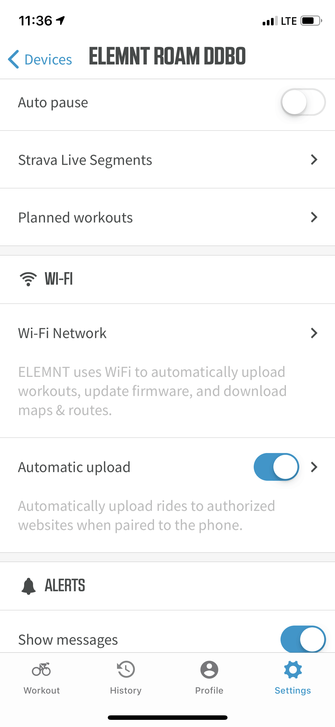
With everything all set, let’s talk basic operation. First up is the unit itself, which has a single button on the left side, two on the right side (up/down), and three along the base of it. The left button is used for power and accessing the settings. The right buttons are used for going up/down menus, and increasing/decreasing data fields. And the lower buttons allow changing of data pages and confirmations within various prompts. All of this matches previous Wahoo units exactly. No changes here.

To access the settings menu, you’ll simply tap the left button once. It’s here that you can pair sensors (though, you can also use the smartphone app for that), as well as configure the backlight (default is ‘Auto’), and specify if you’re indoors or outdoors.

Of course, the most famed part of the Wahoo bike computers is that virtually everything can be set up from your smartphone, using the Wahoo ELEMNT companion phone app. In fact, it’s essentially required to set up and otherwise maintain the ROAM. Fear not, it makes it super easy to get things all set up.

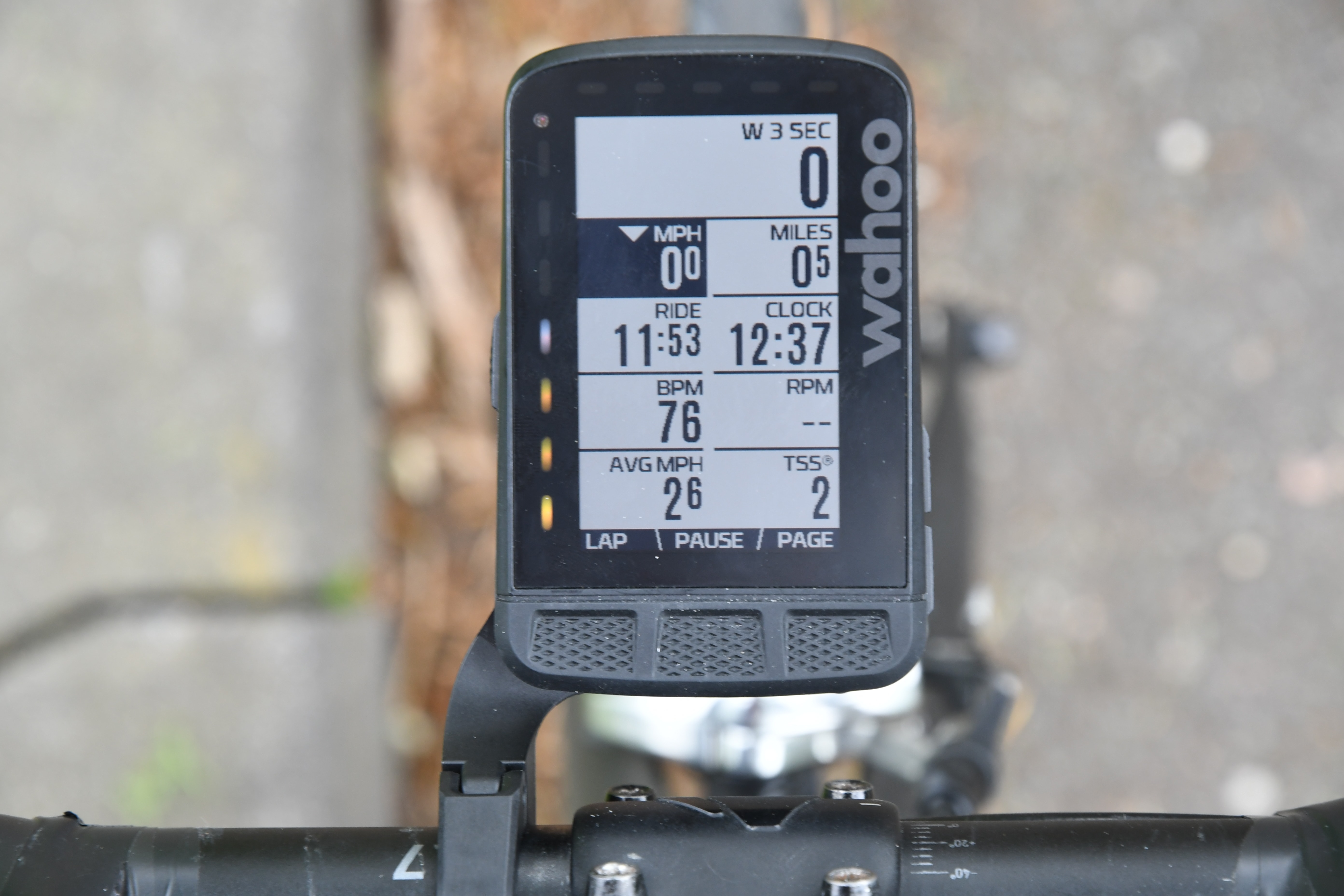
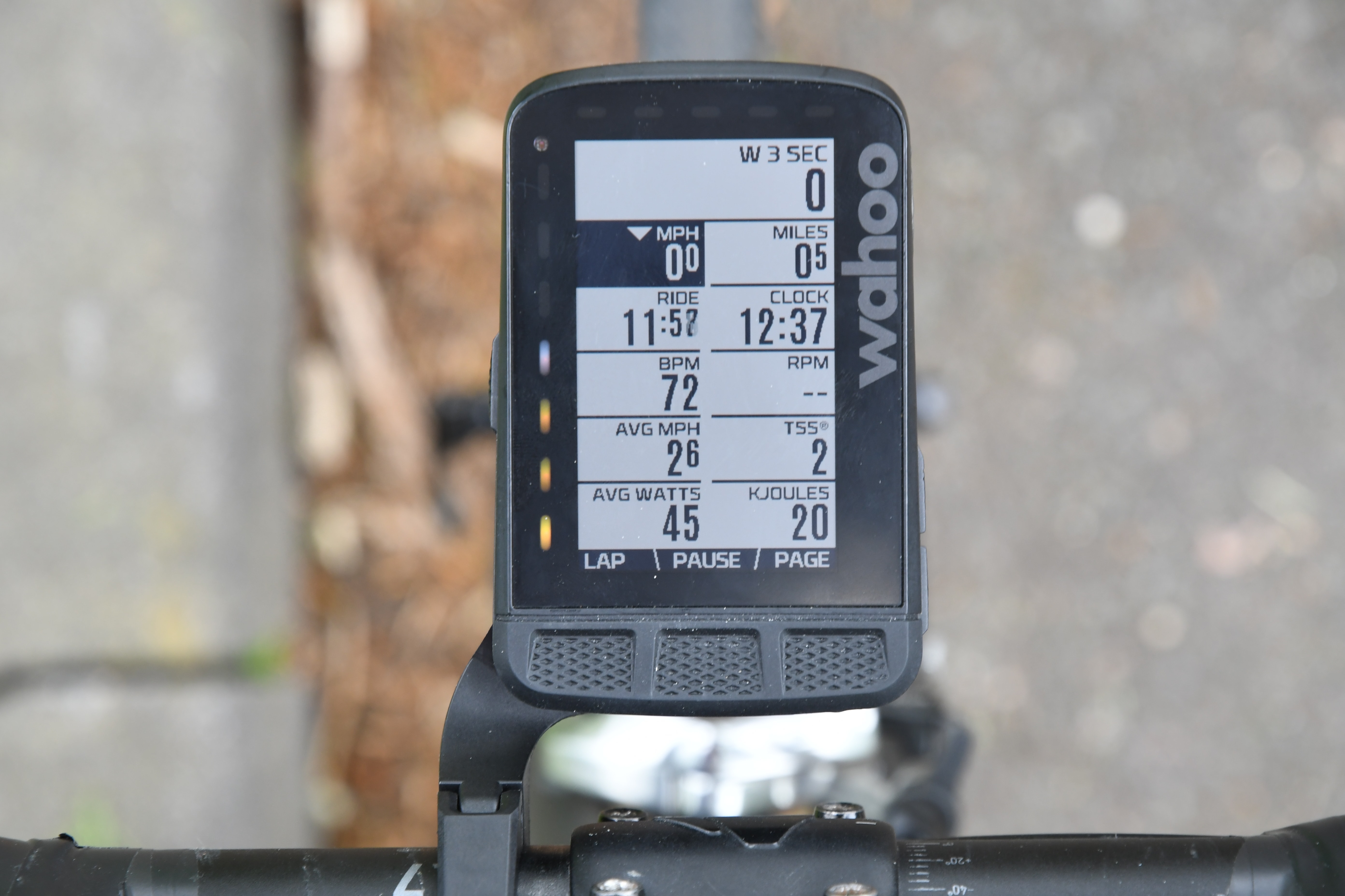
When it comes to ROAM data pages, you’ve got a starter pack of default pages, plus custom ones you can add. By default, you’ll get a lap page, a workout data page, a climbing page, and the map page. Additionally, if in a Strava Segment you’ll get that page, when doing a planned workout that page, and then finally a trainer control page if controlling a trainer (any ANT+ FE-C trainer or any KICKR trainer). Here’s a quick gallery of them.
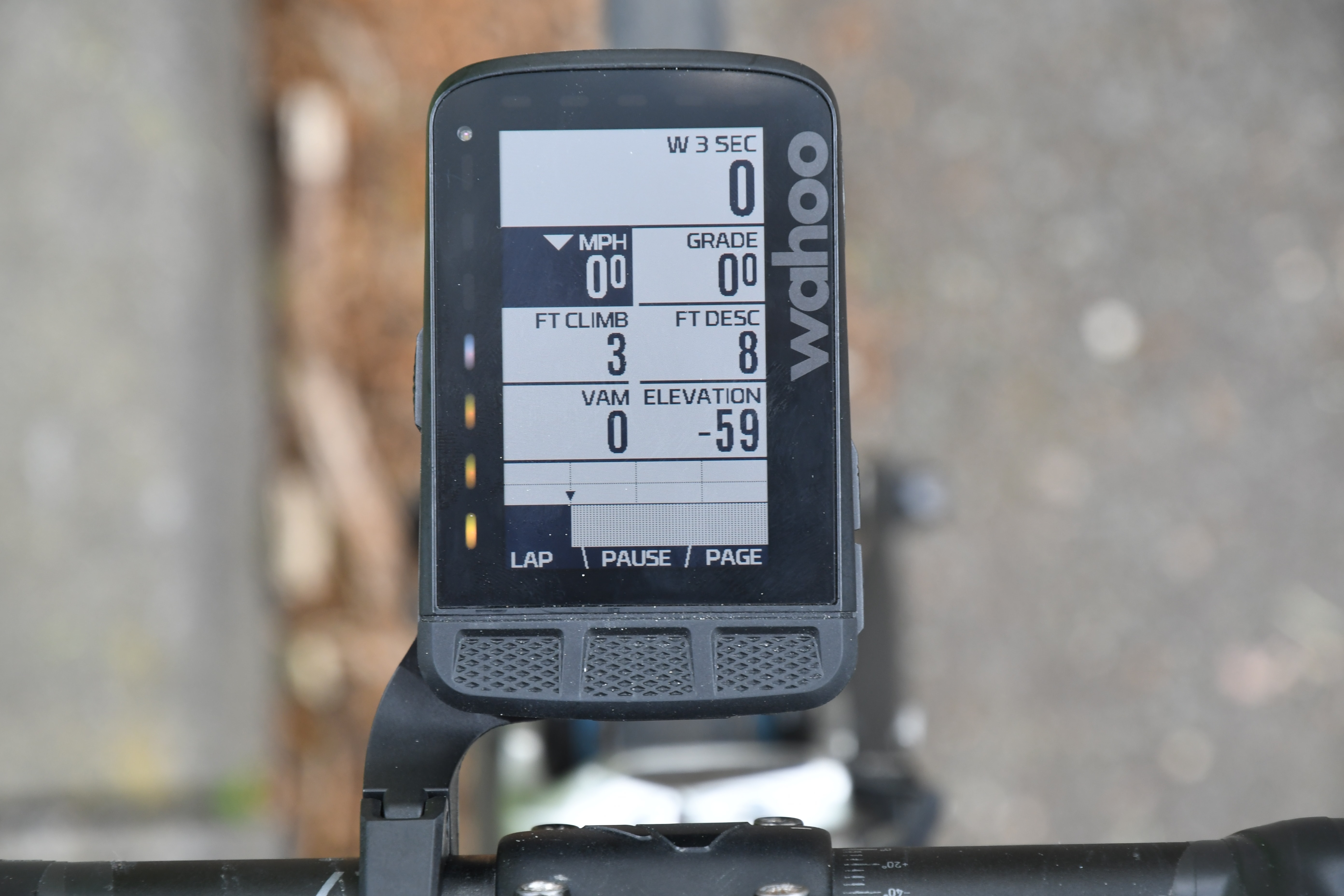
You can also add custom data pages as well. However, data pages (custom or default) are a bit different on Wahoo bike computers. While you customize data pages with the metrics you want like any other bike computer, the number of fields and specific fields that you’ve displayed will vary. Specifically, they’re ordered based on your prioritization, which allows you to increase/decrease the number of fields shown by just pressing the up/down buttons. So when creating custom data pages, you’ll need/want to order which fields are most important to you, so those have higher priority. By default it does this for you, and then you can adjust the ordering.


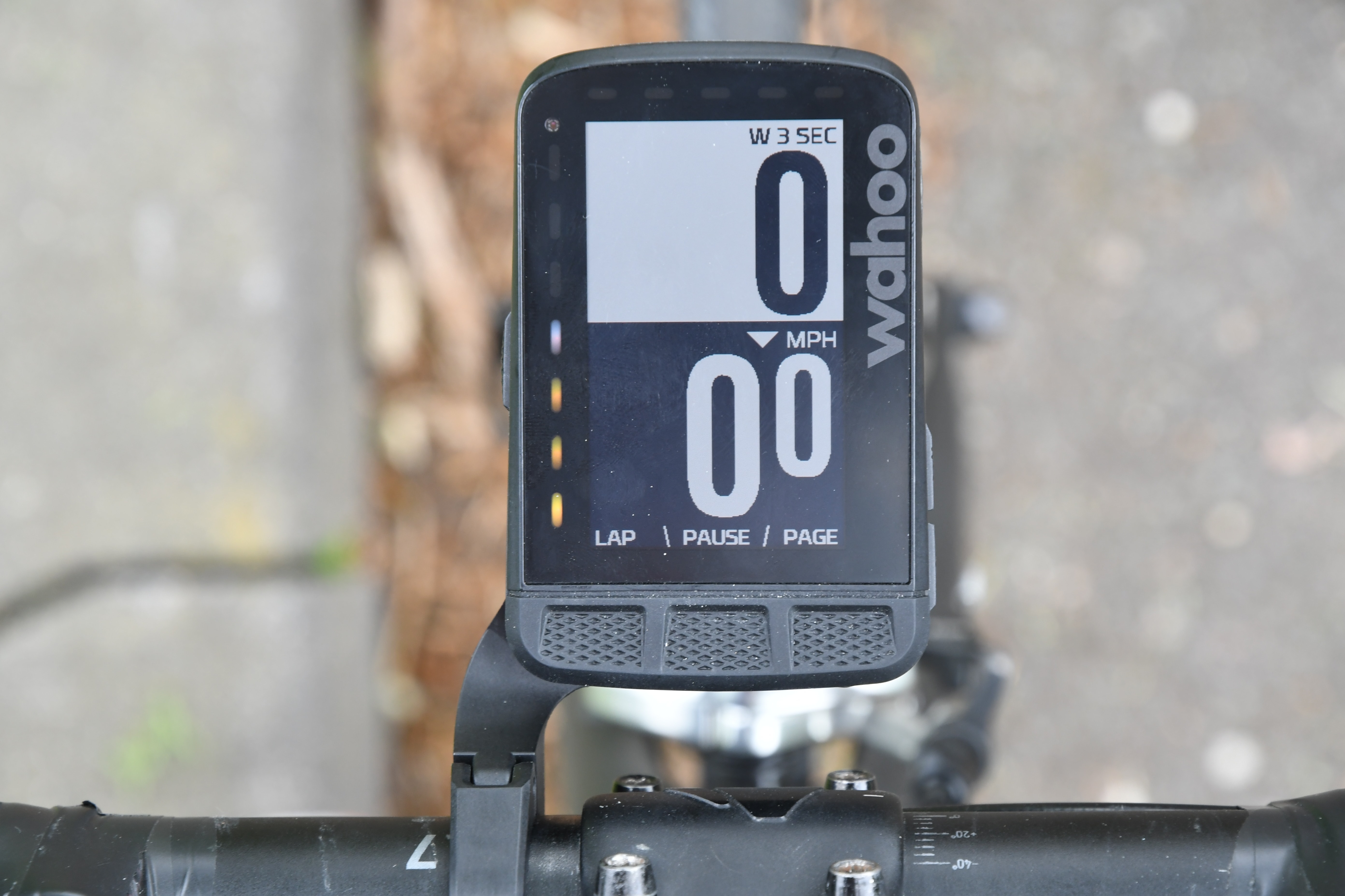
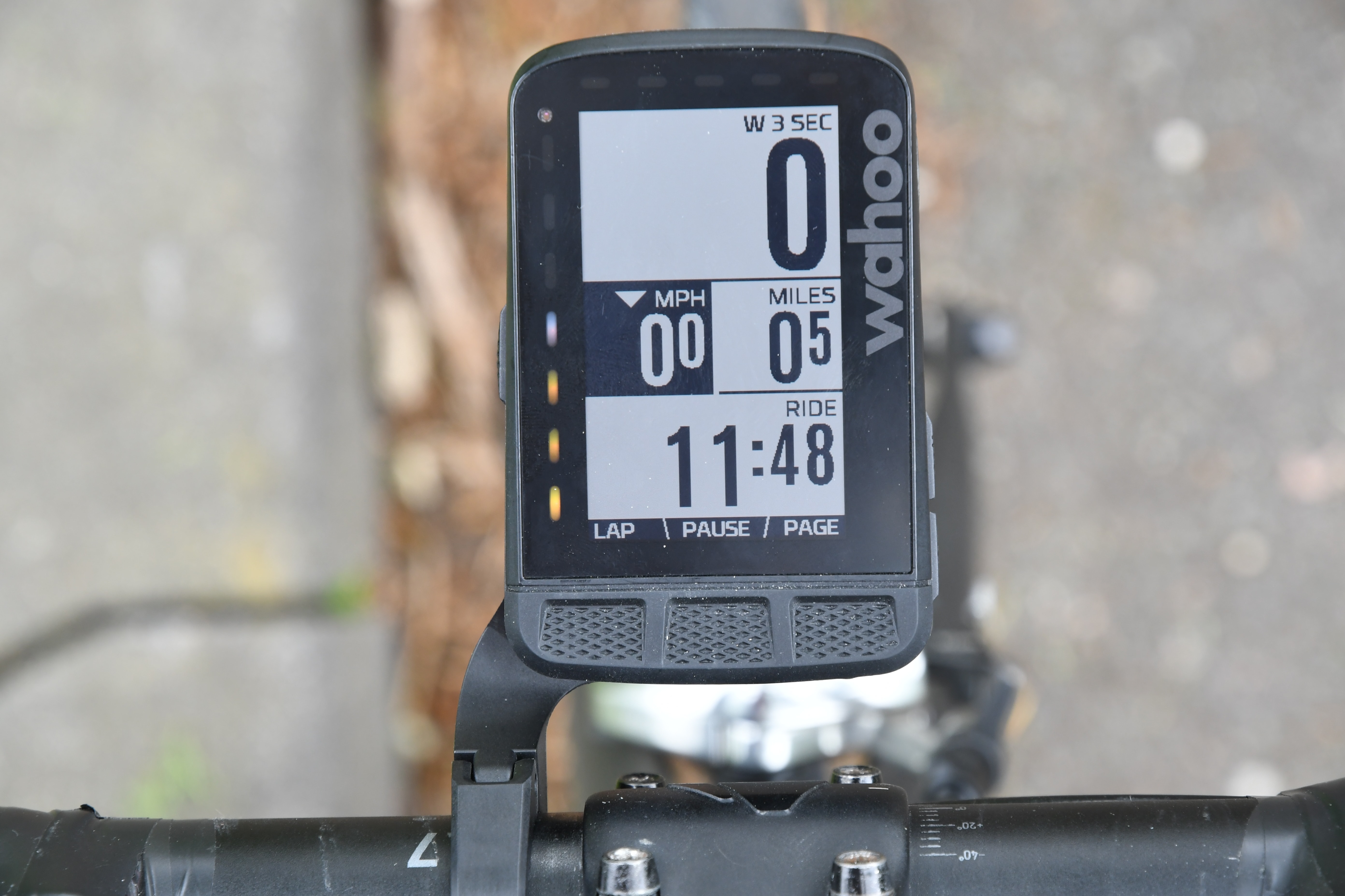
As an example of the scaling, here you can see how below I’m showing a single configured custom data field, but at different levels:
There are boatloads of data metrics to choose from – far more than when Wahoo first started off. Here’s a screenshot of some of them. Like any competitive battle, there’s some fields that Garmin has that Wahoo doesn’t, and some fields that Wahoo has that Garmin doesn’t. For example, Wahoo has more power averaging fields (i.e., more options for stuff like 1-minute power), whereas Garmin has more sensor-driven fields to choose from (like radar, or Di2 battery status).


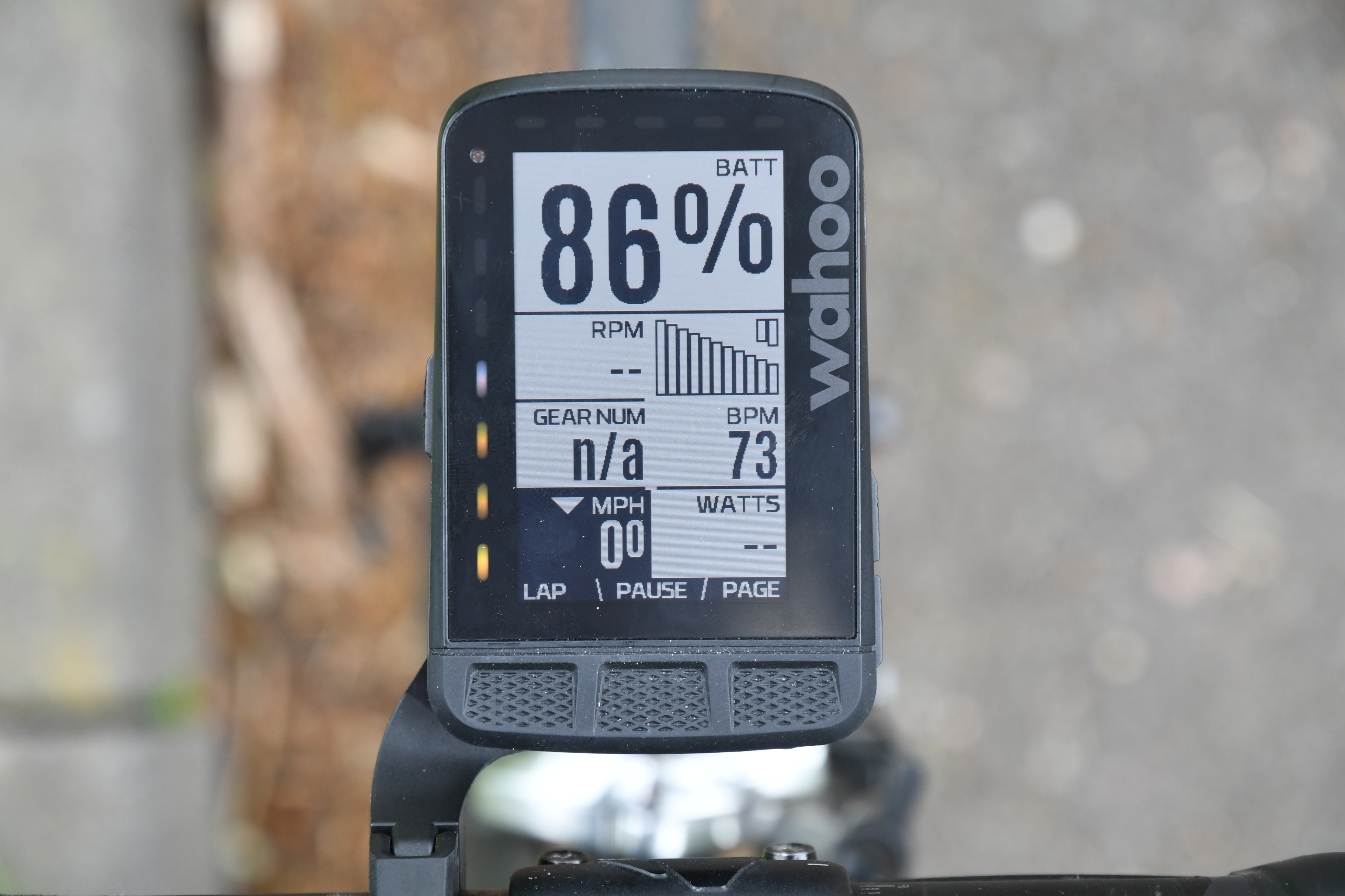
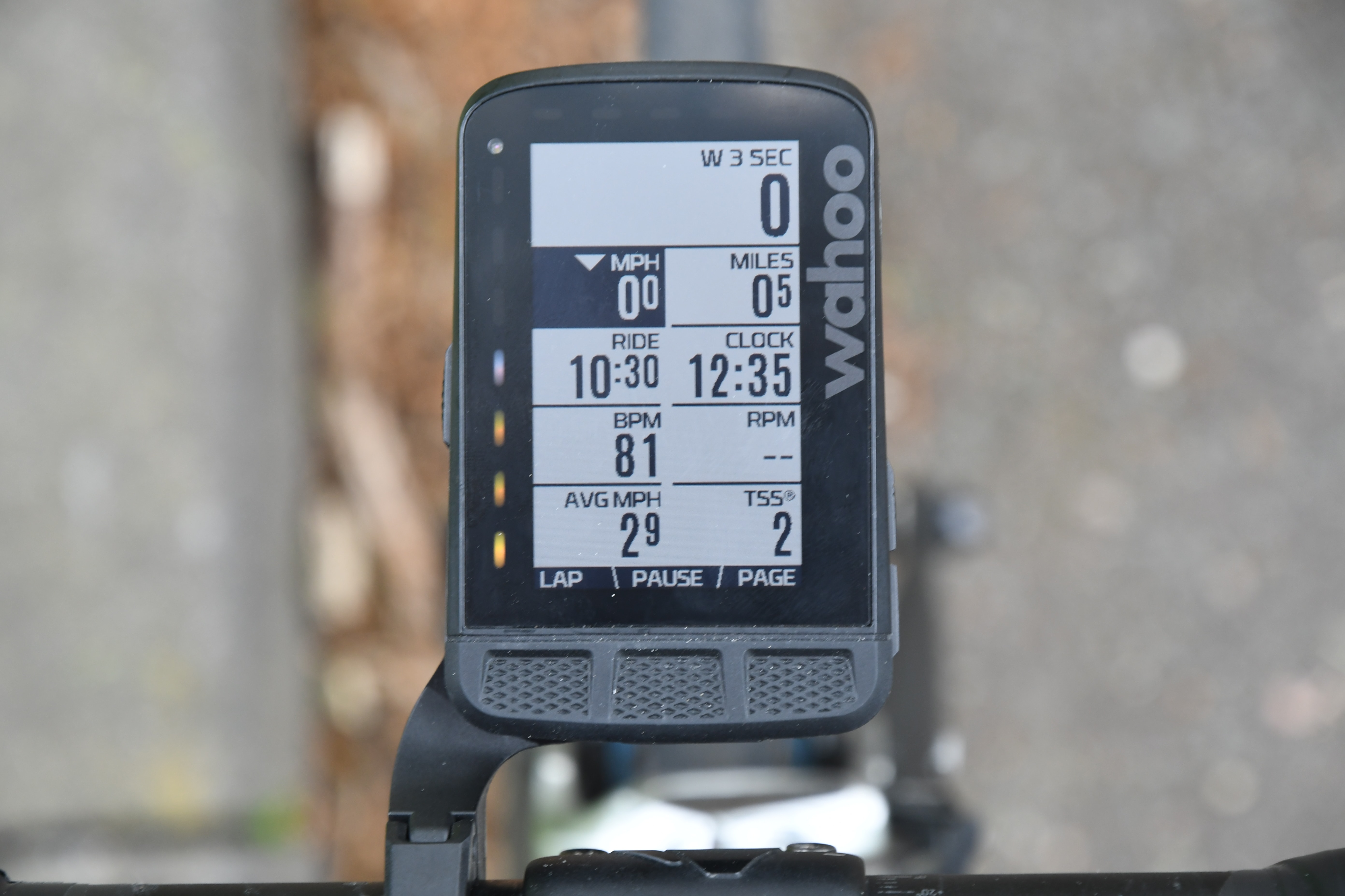
Back on the unit itself, when you’re ready to ride you simply hit the start button and it’ll start recording as you’d expect. It’ll show your data in real-time, and then allow you to increase/decrease data fields as you see fit in real-time. Same goes for changing data pages. Basically, everything you’d expect from a bike computer.

For me, all the basics of the ROAM have worked fine – just as they did on the BOLT and ELEMNT. Note that the ROAM includes both the side and top LED strips on the unit. The top LED’s are used to notify you of things like turns or notifications, while the side LED’s can be configured to show speed/power/HR levels, via the app.


Speaking of notifications, during the ride you’ll see notifications from texts display on the screen (if you’ve configured as such). They’ll even properly show at least some emoji. You know, the most important ones:

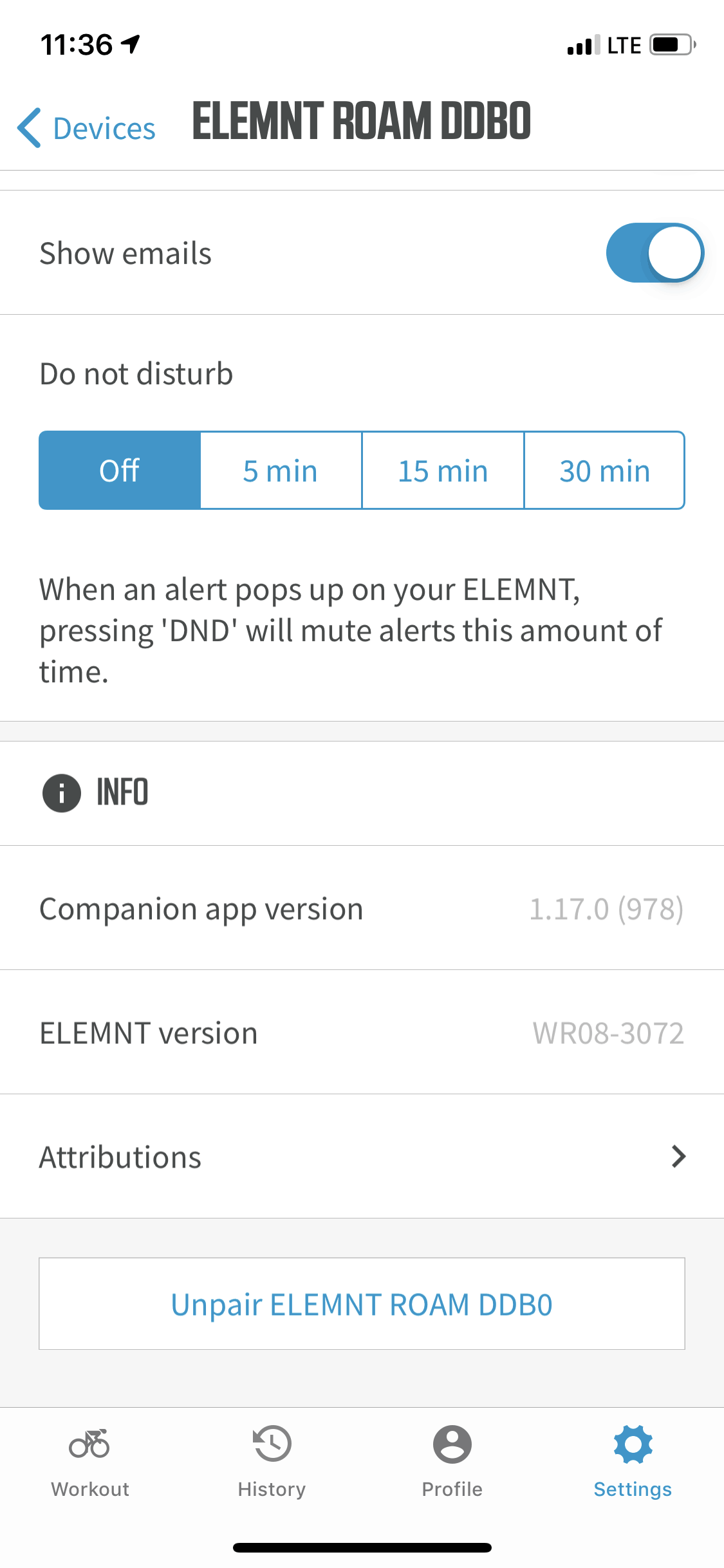
You can also configure a temporary ‘Do Not Disturb’ mode, should you be in the middle of something important (like an interval).


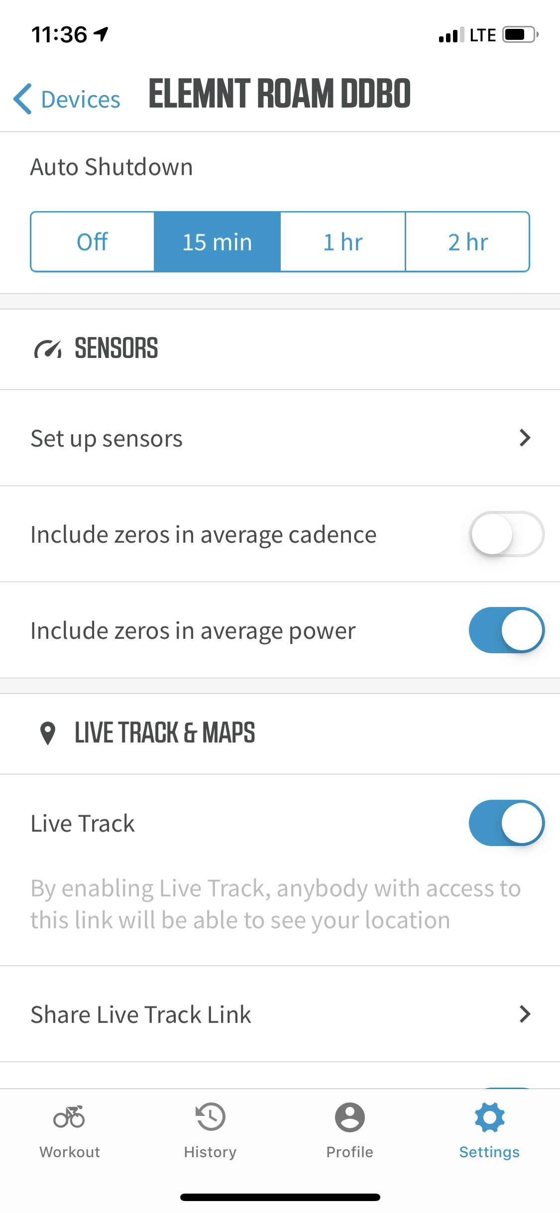
The backlight of the unit is by default triggered via an ambient light sensor – an update from the BOLT which lacked one. This means if you go through a tunnel or it just simply gets dark out, the backlight will come on You can see this setting above. In that same region is the ability to configure auto shutdown.
Once completed with a ride, it’ll sync to the app where you can dive into it in more detail. Lots of detail, looks really nice and clean.

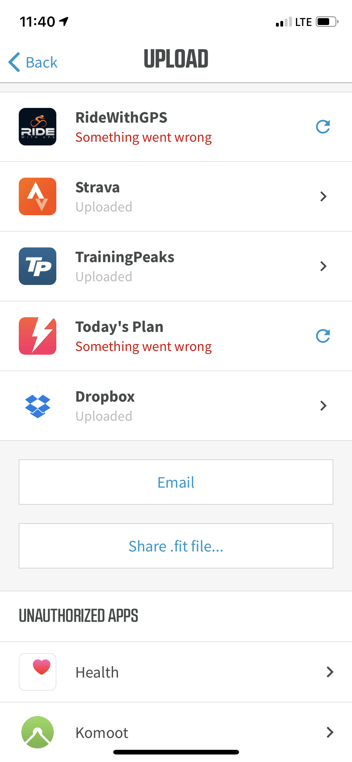
Now unlike Garmin, Polar, Pioneer, or others – there’s no Wahoo specific website to look at your rides on. Instead, you’ll need to use a 3rd party site. The good news is that Wahoo makes this easy, with plenty of connection options (including even Dropbox, my favorite). You’ll use the app to configure these accounts, signing in with credentials as required. Then anytime your unit syncs via Bluetooth or WiFi, it’ll automatically upload to all these servers.


You can also just plug-in the ROAM using micro-USB and grab the .FIT file directly. That’s a pretty common file type standard that most devices use these days for recording fitness data.
Speaking of WiFi and such, the unit uses WiFi to download updates (including maps for other regions), as well as make any 3rd party site connections. Note that like most wearables, the ROAM doesn’t work with Starbucks/hotel or similar hotspots, and needs more of a home/office setup with a specific set password. Not a big deal, just something to be aware of while travelling.


Finally, for lack of anywhere else to plop it, let’s talk battery life stats. The unit is spec’d at 17 hours, which is a 2-hour increase from the ELEMNT BOLT, but matches the ELEMNT.
Sensors & Data:

Back a number of years ago when Wahoo first introduced the ELEMNT series, one of the biggest strengths was the dual ANT+/Bluetooth Smart sensor support. It was one of the first (if not the first) to support sensors of both kinds. These days of course, that’s considered standard practice. All of Garmin’s most recent units have dual ANT+/Bluetooth Smart support, as do those from Hammerhead, Lezyne, Bryton, and more. In other words, you don’t get brownie points for it anymore – it’s considered the baseline.
At present, the ROAM supports the following types of sensors:
ANT+ FE-C Smart Trainers
ANT+ Heart Rate sensor
ANT+ Speed-only sensor
ANT+ Cadence-only Sensor
ANT+ Gear Shifting Profile (SRAM eTAP & Campagnolo EPS)
ANT+ Speed/Cadence Combo Sensor
ANT+ Power Meter
ANT+ Tire Pressure (Quarq TyreWiz)
Bluetooth Smart Heart Rate sensor
Bluetooth Smart Speed-only sensor
Bluetooth Smart Cadence-only Sensor
Bluetooth Smart Speed/Cadence Combo Sensor
Bluetooth Smart Power Meter
Pioneer Power Advanced Cycling Metrics
Shimano Di2 System (via private-ANT)
BSX & Moxy Muscle Oxygenation sensors (via ANT+ Muscle Oxygen Profile)
Wahoo KICKR/CORE/SNAP Trainers
Note that last fall introduced advanced cycling metrics for Pioneer power meter owners, which might be considered a precursor to supporting the ANT+ Cycling Dynamics standard that was ratified last year, for which Favero is said to be soon releasing Assioma firmware support for (and Garmin already supports).
However, the reality is that aside from Pioneer, there hasn’t been a lot of additional sensor types supported – and one that’s been constantly asked for is the ANT+ Bike Radar (aka Garmin Varia sensors). This sensor type is a public/standard sensor type that any company can implement. And the impact on it being a blocker for folks seems to be growing, one can look at the comments section of the Bolt review to see that.
And this point was cemented further while I was at the Sea Otter cycling event a few weeks ago in the Wahoo booth getting some photos. A husband/wife came in and had almost been sold on the BOLT, when the husband asked the wife ‘Oh wait, what about your Garmin radar?’, and then turning to the Wahoo rep said ‘Does it work with that?’. The answer? No. And sale lost.
What has repeatedly talked about looking into support for it (it’s been out many years now), but nothing ever materializes. While the argument can be said that Wahoo doesn’t want to support their competitor. For people with Varia Radar – it’s a hard-stop. So either Wahoo can choose to win the device sale but not get radar money. Or they can choose to lose both device and radar unit sale. Seems like an obvious choice to me – since these are people that are actively looking to leave the Garmin ecosystem.
With all of that out of the way, let’s talk about pairing. With the ROAM you’ll go into the settings menu and immediately see the sensors listed below. You can see the signal strength (and thus status) of the sensor right on the display.

You can select a given sensor to get more information about it. For example, on a power meter, you can select to calibrate it, or even see the left/right sensor status for a unit like the Stages LR Power Meter:

Towards the bottom is the ability to add new sensors. This will search for the nearest sensor first and offer the ability to confirm/pair it:

Alternatively, you can go into the list of sensors nearby and add/select them manually. They are sorted first by sensor type, and then if multiple sensors exist nearby, it’ll show you the individual sensors. This is useful for myself personally, as I have approximately 438 sensors on my bike.

Like most units on the market, you can assign names to the sensors. However, unlike most units, you can do so via your phone with the Wahoo ELEMNT companion app. Again – having the phone companion app has always been Wahoo’s strong point. Also – you can pair from this same menu too, if you have unpaired sensors nearby:


Finally, a brief mention on trainer control. Like Garmin, Wahoo supports the ability to control your trainer via the bike computer. The main use cases for this is to re-ride outside rides indoors on the trainer, and then to execute structured training workouts. Though, you can also just control your trainer manually. I’ve talked extensively about the structured training workouts (and trainer control) in the past, and everything remains the same here. You’ll pair your trainer just like before, this can be a Wahoo trainer or a 3rd party trainer using ANT+ FE-C.

At which point you’ve got several options for how you control your trainer:
Erg Mode (Target Watts): Allows you to specify a given wattage level – i.e., 150w, 237w, 350w, etc….
% Resistance Mode: In this you specify in % a given resistance level – i.e., 10%, 25%, etc… Note that this isn’t grade though, just total resistance available.
Route Mode: Here you specify a saved route (from one of the ones you’ve downloaded to your unit).
Passive Mode: In this case you’ve got another app controlling the KICKR (i.e., Zwift), where the BOLT just chills out and records the data.
Level Mode: Simply set a resistance level, i.e., ‘Level 3’.
Workout Mode: Open a structured workout from the structured training menu
And of course, the last two are ones that allow riding files or structured workouts found on your ROAM. In fact, Wahoo even bundles a few planned workouts on the ROAM from Team INEOS:

While I’ve spent all of my time outdoors with the ROAM, Wahoo says nothing has changed here from the BOLT/ELEMNT – so everything’s same-same in this area (and that’s perfectly fine).
Navigation:

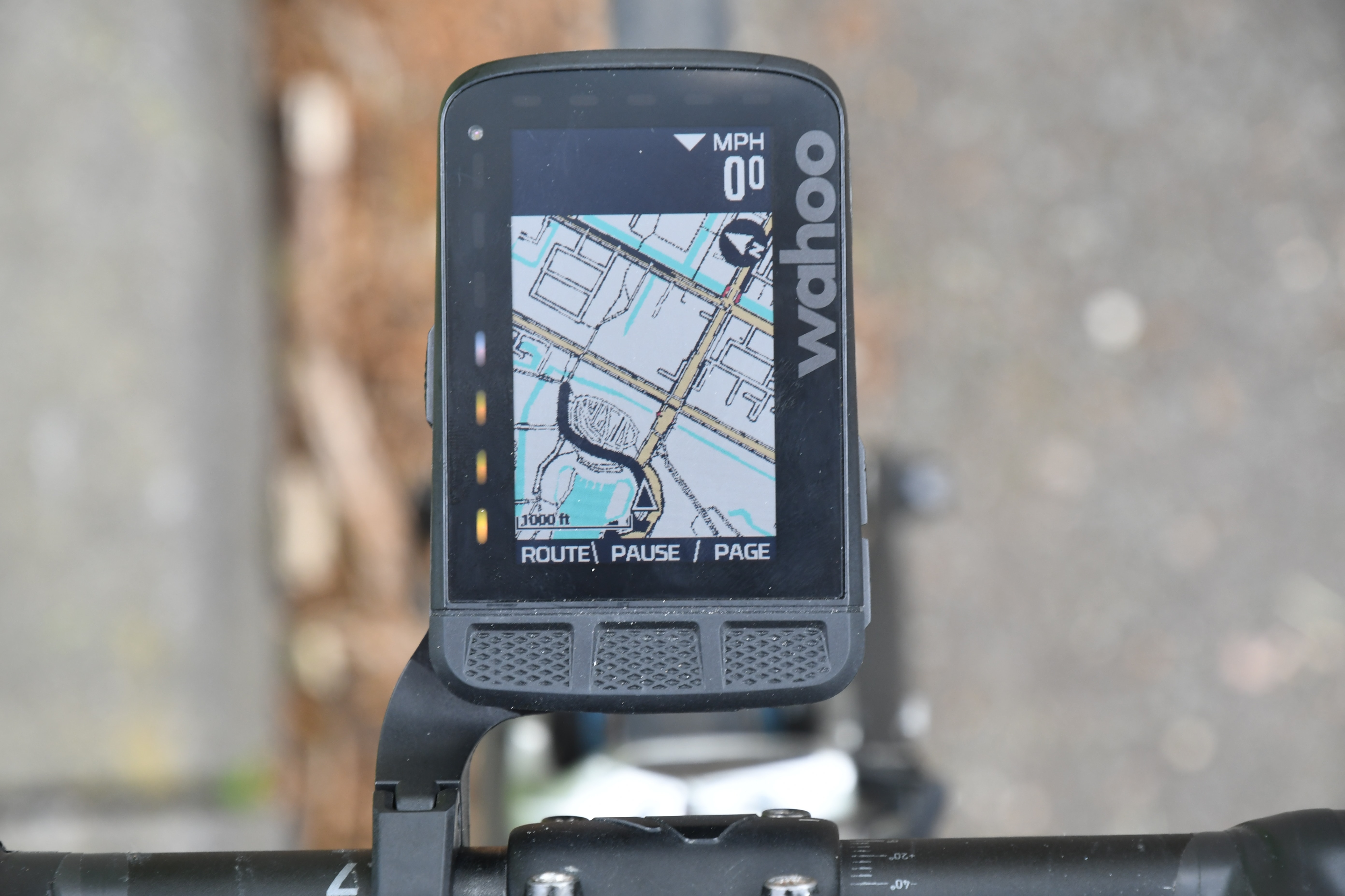
There’s approximately a 100.00% chance that if you’re looking at the Wahoo ROAM, it’s because of the new navigation/mapping features. So I’m going to spend this entire section diving into all those. First though, it’s probably key to understand the difference between what the ROAM has and the BOLT/ELEMNT has. Here, let me sum it up for you:
ROAM: Fully routable mapset, complete with street/trail names (and elevation coming later in June). It can map/route on its own without any other service/platform
BOLT/ELEMNT: Effectively just a penciled picture of map, no street names in the data, nor any routable data – it fully depends on the course turn/street name info from the file/course that you give it
Think of the difference being with ROAM it legit knows all the streets you’re on. It actually knows that you’re on Maple street. Whereas with the BOLT/ELEMNT, it knows your GPS coordinates, and there happens to be a black line representing a street there. But it doesn’t know anything about that street – not even the name or which way the street really is. Instead, it ‘cheats’ by getting that information from your course file. Where that whole system breaks down (previously on BOLT/ELEMNT) is with Strava Routes, as you don’t get detailed turn by turn information with street names. It’s basically just a breadcrumb trail. Whereas when it was used with RideWithGPS, you got turn by turn street details because RideWithGPS included them in the message. In other words – Strava sent Wahoo an empty FedEx box, whereas the RideWithGPS’s box was full of toys. Ironically, just like real life.
In any case, now with ROAM it can – in certain scenarios – self route. And it’s the ‘in certain scenarios’ part where things get a bit…disappointing. Though, some of it is slated to change. First, let’s talk about what it can do. Here are the main ways you can navigate:
Free ride: No route, just ride wherever the heck you want using your brain, you can still see the maps page
Courses: Follow courses breadcrumb style from any number of providers, such as Strava or Komoot
Courses with Turn by Turn directions: Right now this is for one-way routes from the companion app, RideWithGPS, and then later with Strava Routes
Routing to saved locations: You can save a location and get directions to that (such as saving your home)
Routes from a file: Using the app you can route from .FIT, .GPX, .TCX, by opening the file and selecting the Wahoo ELEMNT app
Routing to start of course: This is called ‘Get me started’ and gets you to the start of your route/course
Route to a point on the map: You can use the curser on the device’s map, and then get full turn by turn routing to that point
Route to an address: Using the smartphone app (required), you can specify any address and route to it
Route from history: Using the smartphone app, you can re-ride a past activity
As noted, some of these are done on the unit itself (Route to course, Route to point on map, Route to saved location), whereas others are done/started from the smartphone companion app:

Then there are a few routing options that are used mid-ride:
Route back to start: This gets you back to the start of a ride, using the most direct method possible
Retrace route: This follows the exact route you went out, back to start (note: it won’t account for one-way roads, so you might have to freestyle a bit
Back on track: This gets you back to your route, in the event your free-styling went askew
While these options all sound like a lot, they can roughly be boiled down to: Get me somewhere, get me home, and get me back on track. Which isn’t to sound negative, but just a bit of a reality check. Where the gaps exist between this and other competitive solutions is things like on-device address routing or points of interest routing – which the ROAM lacks. Meaning, you can’t route to a specific address or find nearby cafe’s using the device itself. Now, whether or not you find value in that is a different question. I don’t tend to do either from my head unit often, but generally speaking, if a head unit lacks those functions it’s around the $299 price point, not the ~$399 price point. It’s a core distinction in today’s cycling head unit market.
Still, there are cool things that Wahoo does. For example, let’s take routing providers. In the case of Wahoo, all your routes end up in one bucket on the unit itself, automatically syncing from the cloud service providers. So when I do that, it goes off and grabs my routes from Strava, RideWithGPS, Komoot, etc… So I don’t really have to worry about where those routes came from (it shows the provider name next to it):

Contrast this with Garmin, where I have to open up an often finicky Connect IQ app for each 3rd party routing provider and update/download them manually and individually. Of course, there are more nuanced pros and cons to that approach. With Garmin’s approach we don’t have to wait for Wahoo to integrate with new providers/companies, since that company can just create their own app and you’re good to go.
In any case, once you select a route from the list you’ll get a cue sheet of directions, depending on the provider. As of today, you won’t get those instructions for Strava. Wahoo says they’ll have that integration completed by the end of May, but I have my reservations on that timeline (I have beta access today to it). For me, I almost exclusively use/store my routes in Strava, as it allows me to have them act like the Switzerland of routing – every device supports it.
While routing, you can stay on the map/cue sheet, or you can stay on your regular pages. For routes that support turn by turn navigation, you’ll get a pop-up message that the turn is coming up (though, not yet today with Strava). I’ve found it rather variable whether I’ll get actual street names, or just turn left/right. It seems like the ROAM isn’t terribly sure where it is (exactly, in terms of streets) a lot of the time.

And if the route provider has elevation data included, then you’ll see the upcoming elevation shown on the unit as well. Note, there’s a lot of if/then statements on which route options/providers include them and which don’t.

If you go off route, it’ll try and recalculate the route for you. I’ve had varying results with what it attempts to do next – specifically around how strict it is to getting you back on course. There’s roughly two ways it can do this. First is to get you back to the exact point you left the course, or the second is to get you on course somewhere down the road as it makes sense. In general it appears that (for at least my roads/routes) Wahoo is more strict in trying to get you back closer to where you left the route. Whereas Garmin appears to take the approach of ‘we’ll catch-up somewhere down the road’. Obviously a bit of personal preference is applied to which you prefer. If the shortest distance is your goal, then Garmin usually does that better. Whereas if sticking to your exact route is more important, Wahoo appears to do that better.
No matter how you found yourself off-route, when in the midst of re-routing, you’ll note how the route chevron color is blue:

The recalculation speed seems fast enough for me, on par with competitors. As for the route selection, the options it selected varied between being good and less than ideal. Part of the challenge Wahoo has is that while they’re using the same OSM base mapping data as Garmin, they don’t have the gigantic vault of heatmap data that Garmin has (which Garmin calls ‘trendline popularity routing’). That means that Garmin is able to leverage the millions or so activities probably uploaded every day to figure out where people are actually riding/working out – which improves picking better roads. Again, it’s hardly a deal breaker, but I’d love to see Wahoo find some way to partner with Strava to get access to that kind of data to overlay and improve routing.
If you want to retrace a route back to the start, or route home – then select either option from the routes menu:

Speaking of blue chevrons, this is as good a time to talk about that ‘color’ display. Yes, I know Wahoo advertises it as a color display, but so is my toddler’s box of 8 crayons sitting next to me. See, the ROAM display only appears to have 7 core colors, including black and white – one color less than my daughter’s box of crayons. I’m not saying you need to constantly use additional colors, but it also doesn’t hurt either. The colors are mainly used as follows:
#1: Red: On power-off, edges on bridges
#2: Green: Text message notifications
#3: Yellow: Main roads on the map
#4: Blue: Water on the map, re-routing chevrons, live tracking labels
#5: Orange: Strava integration
#6: Black: Text/roads/lines/etc
#7: White: Everything else
Now, it’s now quite as simple as that. As Wahoo does blend some colors a bit here and there. For example, in the photo slightly below you see teal. And in the picture of the text message you see purple. My guess is that it’s actually a 32 or 64 color screen, even though they don’t use most of them.
In addition, during structured workouts, you get all the colors of the rainbow.
And while the display is clear, the colors are hardly bright. Again, I’m not sure I need super bright colors – but let’s be honest, these ones are pretty dim. I was kinda hoping for a more vibrant display. There’s undoubtedly a trade-off between display and battery life, but the Edge 530/830 and Hammerhead Karoo displays are far more brilliant than the ROAM. And the battery life on the Edge 530/830 is equal or double, depending on the configuration. And the speed of the basic user interface bits (how fast it reacts) is far slower than competitors. Way slower.

Speaking of that map, let’s talk about how to route from the device itself. First, to note is that there’s only a single routing related option, which is to define your surface type. That’s located under Routes > Routing Options on the device (Road/Cross/Hybrid/Mountain):

It’s here in the routes area that you can select the ‘Take me to’ option. That then allows you to route to saved locations or a location on the map. Saved locations appear in the list just by the street name. You can’t define a list of saved locations ahead of time, or adjust the names for them. You can only save your current location on the map.


If you selected ‘Location on Map’, this then pulls up the map with a crosshair that you can select where to route to:

You can zoom in/out, as well as pan and scroll using the bottom three buttons. The ‘…’ changes between pan/scroll/zoom, as well as gets you to the option to navigate to that point. You can see an example here of it not exactly knowing what the roads are a lot of the time.

Once you select a point it’ll automatically create the route to that point, including turn by turn directions:


Note that at this point the ROAM doesn’t have any baked in elevation data, so you won’t get any upcoming elevation profile for any routes created on the companion app or on the device itself. Wahoo says this is planned by the end of June (a timeline I think is reasonable).
For any other point to point routing you want to do, you’ll need to use Wahoo’s companion app, which allows you to create a route to a single point. You can’t create looped routes this way, though you can use the free 3rd party Easy Route app to do so. And funny enough, the developer of that app now works for Wahoo. It’s the routing app I use for creating quick one-off routes on both my Wahoo and Garmin devices. In any case, here’s the default routing app. Note that it presumes you’re starting from your current GPS location.

It’ll then create a route and you simply choose ‘select route’ from the list, after which it loads the route on the ROAM:

At that point you’re routing/navigating just like any of the other routing options. It’ll give you turn by turn routes, but no elevation at this point. Only 3rd party providers include elevation data (ironically enough, Strava includes elevation data).
I’ll point out that this is probably the cleanest/best part of the Wahoo experience- creating the route on the phone is super quick and efficient, and transfers near-instantly to the head unit.
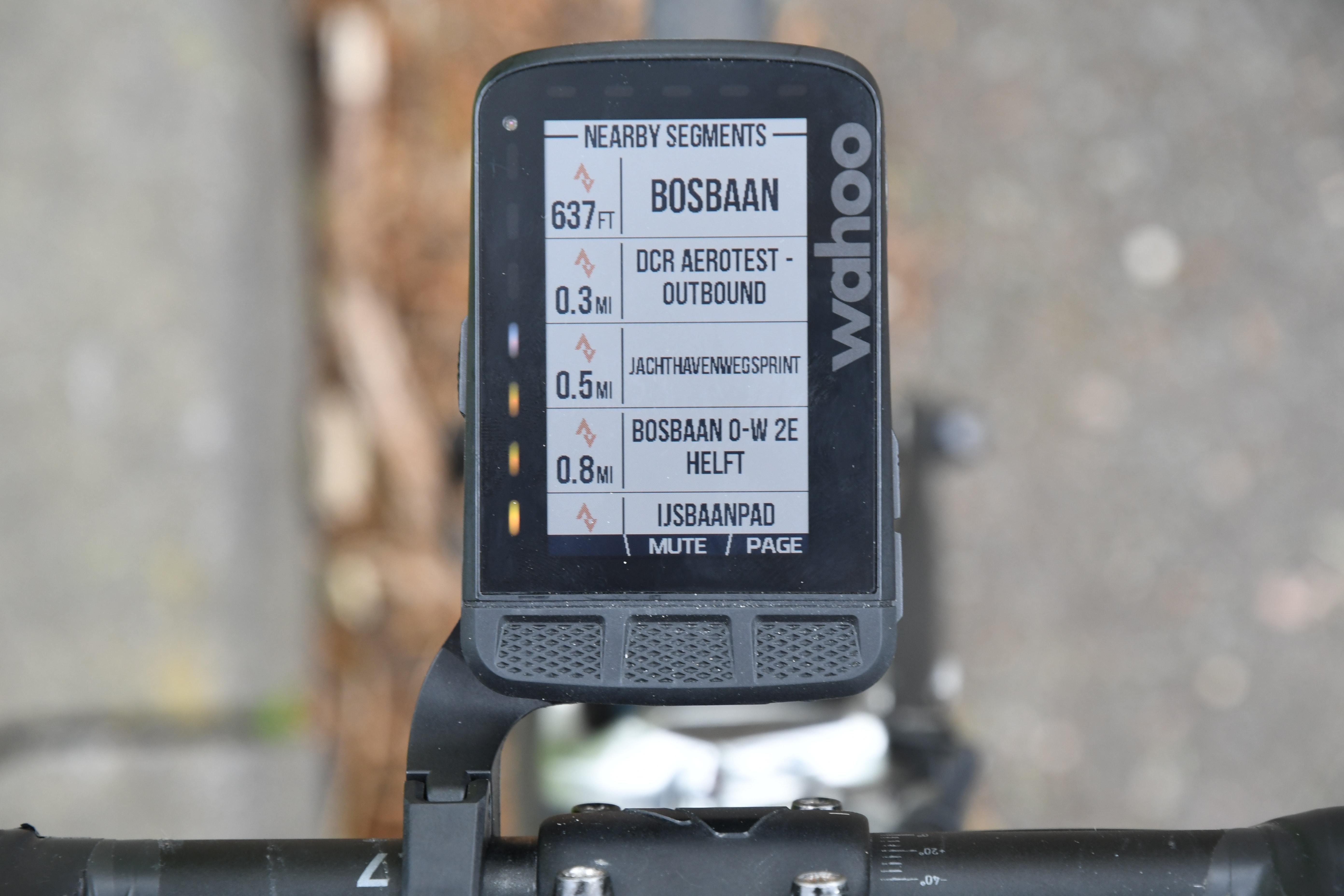
Finally, the ROAM will automatically pull in any starred Strava segments that you have in your account. You’ll then see these listed on the device itself:

And then when navigating you’ll see that nearby segments show up as well. As you enter a segment you’ll get Wahoo’s Strava Segment overlay, which is one of my favorites because you can compete on multiple overlapping segments at the same time. You can toggle who you’re competing against at the bottom (KOM or PR), as well as change the segment by pressing that button:


You can always get back to other data pages by pressing the ‘Page’ button. Also, you can always use/race Strava Segments, even while on a course. Garmin has a weird limitation that if you’re actively navigating a Garmin Connect/other course, you can’t concurrently see/race Strava Segments. You can only concurrently navigate and get Strava Segments on a Garmin device if you’re navigating a Strava Route, because then the Segments are baked into that route. So this is an advantage over that if you’re into Strava Segments and other routing providers than Strava.
Oh, and you’ll get elevation on Strava segments too, assuming your geography supports that. Here’s a shot when I was riding down in Spain:

In any case, as for Wahoo’s overall navigational capabilities – it’s not bad, at least once they get Strava turn by turn added, and elevation data added for routes. Once that happens it’ll be good, but not $379 good.
And that’s sorta at the core (no, not KICKR CORE, just regular core), of my issue with the ROAM: It’s just not priced right. The features/functionality on this unit are equal to a $279-$299 price point. That’s what the market shows, and Wahoo isn’t doing enough other special things to justify an additional $100-$120. Atop that, if we look at the navigational options of their competitors, they’ve got way more rich features. Points of interest are shown on the maps automatically, as are more details about streets. For example, street names aren’t shown on the Wahoo ROAM – and while I don’t always need to know the street name, there are countless scenarios where that’s useful.
I will note however that one super solid point of Wahoo is that they include the maps for all regions. By default the maps will come loaded for your region, and then you can tap to download maps for other regions if you travel. This matches Sigma and Hammerhead, whereas Garmin requires you pay for additional maps – or download them for free from 3rd party sites (which is cumbersome and annoying at best). So props to Wahoo for continuing to make it easy.
GPS & Elevation Accuracy:

There’s likely no topic that stirs as much discussion and passion as GPS accuracy. A watch could fall apart and give you dire electrical shocks while doing so, but if it shows you on the wrong side of the road? Oh hell no, bring on the fury of the internet!
GPS accuracy can be looked at in a number of different ways, but I prefer to look at it using a number of devices in real-world scenarios across a vast number of activities. I use 2-6 other devices at once, trying to get a clear picture of how a given set of devices handles conditions on a certain day. Conditions include everything from tree/building cover to weather.
Over the years I’ve continued to tweak my GPS testing methodology. For example, for watches I try to not place two units next to each other on my wrists, as that can impact signal. For cycling units, I arrange them on my handlebars using standard mounts – usually one on either side of the stem, often a bit separated from each other.
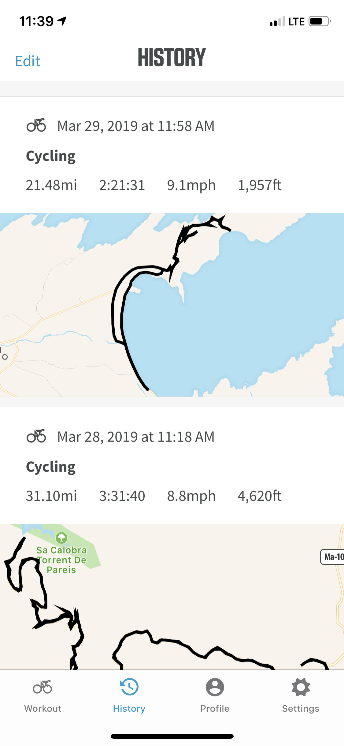
Next, as noted, I use just my daily training routes. Using a single route over and over again isn’t really indicative of real-world conditions, it’s just indicative of one trail. The workouts you see here are just my normal daily workouts. I’ve had a fair bit of variety of terrain within the time period of testing ROAM. This has included workouts in: Amsterdam (city, countryside) and Mallorca (mountains, ocean, countryside), California (off-road, hills, forests, seaside).
We’re gonna look at a few different rides in different parts of the world. First, we’ll start with the famed Sa Calobra in Mallorca. I rode this nearly a month ago, so while this firmware was slightly older, it still shows pretty solid GPS performance. In this case it’s compared against a Garmin Edge 530 and Edge 830 unit (like the ROAM, technically beta firmware at the time), as well as a Garmin MARQ. I had a Samsung Galaxy Active GPS watch on there too as well, but frankly nobody wants to see that GPS track hosing up this otherwise beautiful route. Here’s that data set:
![image_thumb[17]](https://media.dcrainmaker.com/images/2019/05/image_thumb17.png "image_thumb[17]")
Now, basically everyone in this picture was on some form of beta at the time, but that’s OK, they all did pretty well. Don’t worry, we’ll get to final firmware in a moment. In particular, let’s zoom in to one of the toughest sections on this ride – this bit here as I’m up against cliffs and mountains. Heck, even a bridge overpass:
![image_thumb[19]](https://media.dcrainmaker.com/images/2019/05/image_thumb19.png "image_thumb[19]")
Everything here from the ROAM is spot-on. Like I said in yesterday’s reviews – its boringly perfect. No NASCAR crashes here.
![image_thumb[21]](https://media.dcrainmaker.com/images/2019/05/image_thumb21.png "image_thumb[21]")
Even when some of the other beta units struggled on a turn, the ROAM nailed it:
![image_thumb[23]](https://media.dcrainmaker.com/images/2019/05/image_thumb23.png "image_thumb[23]")
Now altitude was a bit of a funny one. It seems everyone made mistakes here. The one thing ROAM got most correct was me getting close to the sea. My turnaround point was basically a fishing village, elevated perhaps 5-8 meters above sea level. But we see drift from both. See, that low-point there I stopped and ate lunch. Yet we see the ROAM’s elevation slowly climbing up.
![image_thumb[25]](https://media.dcrainmaker.com/images/2019/05/image_thumb25.png "image_thumb[25]")
Of course, at the same time, we also see the Garmin units having trouble too. The MARQ is drifting (again, beta as well), while the two Edge units were simply off-set from the start (bad elevation fix where I started apparently). I haven’t seen any of those elevation issues again as I’ll show. So in some ways the chart is more of a curiosity than anything.
Next, let’s switch to another route that’s also pretty difficult GPS-wise, this one at the tip of the island. In this case the route is compared against a Garmin Edge 520 Plus and Edge 1030, along with a beat Garmin MARQ. I had a Samsung Galaxy Active GPS watch on there too again, but we’ll skip it as well like last time. Here’s the data set:
![image_thumb[1]](https://media.dcrainmaker.com/images/2019/05/image_thumb1.png "image_thumb[1]")
Let’s zoom into one of the more challenging sections – this part right here. It’s in this area that the road has cliffs on both sides, along with some decent tree cover. Here’s the route:
![image_thumb[3]](https://media.dcrainmaker.com/images/2019/05/image_thumb3.png "image_thumb[3]")
As you can see, the ROAM is perfectly spot-on the road the entire time, even if I zoom way the heck in:
![image_thumb[5]](https://media.dcrainmaker.com/images/2019/05/image_thumb5.png "image_thumb[5]")
Next, let’s look at the famed tunnel. When it comes to tunnels (or large bridges), I’m looking for the unit to not freak out. In other words, it should correctly pass in through the tunnel without any GPS wonkiness, and then come out clean the other side. Basically, it shouldn’t do what the Edge 520 Plus did below. Of course, I made life difficult here on all the units because I actually stopped just after I went through the tunnel (coming back), still below a cliff edge. So while it’s pretty rare for me to see what the Edge 520 Plus did (I’ve never seen that before on it), I’m glad to see the ROAM nailed it.
![image_thumb[7]](https://media.dcrainmaker.com/images/2019/05/image_thumb7.png "image_thumb[7]")
And no issues at the end of the turnaround either. Funny tidbit: You can see where I left the units on my bike and then walked closer to the edge with the MARQ still on my wrist.
![image_thumb[9]](https://media.dcrainmaker.com/images/2019/05/image_thumb9.png "image_thumb[9]")
So what about elevation on this ride? Ask and you shall receive. Now, remember that in this ride the MARQ was on beta (just like the ROAM), and there was a bug they’ve already dug into since then (35 days ago) hopefully addressing that issue. You can see how it got a bad fix to begin with, and it just stayed bad.
![image_thumb[11]](https://media.dcrainmaker.com/images/2019/05/image_thumb11.png "image_thumb[11]")
The remainder of the units nailed it though. In fact, since I started across the street from the beach, and it’s nice to see the remainder of the units perfectly got my starting elevation at about 1 meter. Nice!
![image_thumb[13]](https://media.dcrainmaker.com/images/2019/05/image_thumb13.png "image_thumb[13]")
Next, let’s fast forward a few weeks and a few thousand miles away to California, where I’ve got a sea-side route that then gains some elevation while going through some gigantic forests. Here’s the data set:
![image_thumb[27]](https://media.dcrainmaker.com/images/2019/05/image_thumb27.png "image_thumb[27]")
Starting off with an easy section – along the coastline, things look quite nice:
![image_thumb[29]](https://media.dcrainmaker.com/images/2019/05/image_thumb29.png "image_thumb[29]")
Now for some portions of this ride I had the units in/out of my pockets, as I was shooting/filming other things. So in those cases we saw slightly degraded GPS performance in those scenarios (totally logical). So let’s look at a clean section, where they were on the handlebars:
![image_thumb[31]](https://media.dcrainmaker.com/images/2019/05/image_thumb31.png "image_thumb[31]")
Here we were next to a highway, but actually we were also under some pretty significant trees on the trail and a substantial hill next to that. Super clean track through here. Same is true in town, even getting the correct side of the road properly:
![image_thumb[33]](https://media.dcrainmaker.com/images/2019/05/image_thumb33.png "image_thumb[33]")
And lastly, a ride last Friday through the tulip fields. In this case, it’s compared against an Edge 830 (on production firmware), and a Forerunner 945 (also production firmware), and a FR245 (also production). Production all around! Here’s the data set:
![image_thumb[35]](https://media.dcrainmaker.com/images/2019/05/image_thumb35.png "image_thumb[35]")
Frankly, it’s pretty boring:
![image_thumb[37]](https://media.dcrainmaker.com/images/2019/05/image_thumb37.png "image_thumb[37]")
Nobody ever messes up:
![image_thumb[39]](https://media.dcrainmaker.com/images/2019/05/image_thumb39.png "image_thumb[39]")
Like I said…boring:
![image_thumb[41]](https://media.dcrainmaker.com/images/2019/05/image_thumb41.png "image_thumb[41]")
The elevation might appear crazy at first, but then carefully look at the scale. Welcome to the Netherlands. Sure, the FR245 is all wonky, but that doesn’t have a barometric altimeter, so that is what it is. The ROAM and Edge 830 are only 5 meters apart. It just looks jaggy because it’s simply oscillating ~1 meter, which is all it takes here. And that’s probably logical given the natural ups and downs. Though it’s clear Wahoo smooths things a little bit better than Garmin.
![image_thumb[44]](https://media.dcrainmaker.com/images/2019/05/image_thumb44.png "image_thumb[44]")
Ultimately – it should be pretty clear here I’m seeing absolutely zero GPS issues. It’s perfectly nailed from everything I’ve seen, even in the trees or next to mountains. And from an altimeter standpoint, I’m not seeing anything to worry about. Though I lack the geography to continue to test altitude related goodness going forward. So I kinda have to do that when I travel.
(Note: All of the charts in these accuracy portions were created using the DCR Analyzer tool. It allows you to compare power meters/trainers, heart rate, cadence, speed/pace, GPS tracks and plenty more. You can use it as well for your own gadget comparisons, more details here.)
Product Comparison:
I’ve added the Wahoo ROAM into the product comparison calculator so you can see how it compares to other units on the market. To keep things simple for below, I’ve compared it against the Wahoo BOLT, Edge 530, Edge 830, and Hammerhead Karoo. Of course, there are plenty more units in the product comparison calculator, so you can make your own charts here as well. In the meantime, here’s how things line-up below:
| Function/Feature | Wahoo ELEMNT ROAM | Wahoo ELEMNT BOLT | Garmin Edge 530 | Garmin Edge 830 | Hammerhead Karoo |
|---|---|---|---|---|---|
| Copyright DC Rainmaker - Updated May 22nd, 2024 @ 6:39 am New Window | |||||
| Price | $379 | $229 | $299 | $399 | $399 |
| Product Announcement Date | May 1st, 2019 | Mar 14th, 2017 | Apr 24th, 2019 | Apr 24th, 2019 | May 2nd, 2017 |
| Actual Availability/Shipping Date | May 8th, 2019 | Mar 14th, 2017 | Early May 2019 | Early May 2019 | Feb 9th, 2018 [No longer available] |
| GPS Recording Functionality | Yes | Yes | Yes | Yes | Yes |
| Data Transfer | Bluetooth Smart, WiFi, USB | Bluetooth Smart, WiFi, USB | USB, Bluetooth Smart, WiFi | USB, Bluetooth Smart, WiFi | WiFi |
| Waterproofing | IPX7 | IPX7 | IPX7 | IPX7 | IP67 |
| Battery Life (GPS) | 17 hours | 15 hours | 20 Hours (40 in battery Saver Mode) | 20 Hours (40 in battery Saver Mode) | 10-15hrs |
| Solar Charging | No | No | |||
| Recording Interval | 1-second | 1-second | 1-Second or Smart | 1-Second or Smart | 1-second |
| Dual-Frequency GNSS | No | No | |||
| Alerts | AUDIO/VISUAL + LED's | AUDIO/VISUAL + LED's | Audio/Visual | Audio/Visual | Visual |
| Ability to download custom apps to unit/device | No | No | Yes | Yes | In future | Music | Wahoo ELEMNT ROAM | Wahoo ELEMNT BOLT | Garmin Edge 530 | Garmin Edge 830 | Hammerhead Karoo |
| Can control phone music | No | No | No | No | No |
| Has offline music storage and playback | No | No | No | No | No |
| Streaming Services | No | No | No | No | Payments | Wahoo ELEMNT ROAM | Wahoo ELEMNT BOLT | Garmin Edge 530 | Garmin Edge 830 | Hammerhead Karoo |
| Contactless-NFC Payments | No | No | Connectivity | Wahoo ELEMNT ROAM | Wahoo ELEMNT BOLT | Garmin Edge 530 | Garmin Edge 830 | Hammerhead Karoo |
| Bluetooth Smart to Phone Uploading | Yes | Yes | Yes | Yes | No |
| Phone Notifications to unit (i.e. texts/calls/etc...) | Yes | Yes | Yes | Yes | No |
| Live Tracking (streaming location to website) | Yes | Yes | Yes | Yes | Yes |
| Group tracking | Yes | Yes | Yes | Yes | No |
| Emergency/SOS Message Notification (from watch to contacts) | No | No | Yes | Yes | No |
| Built-in cellular chip (no phone required) | No | No | No | No | Yes (with SIM card added) | Cycling | Wahoo ELEMNT ROAM | Wahoo ELEMNT BOLT | Garmin Edge 530 | Garmin Edge 830 | Hammerhead Karoo |
| Designed for cycling | Yes | Yes | Yes | Yes | Yes |
| Power Meter Capable | Yes | Yes | YEs | YEs | Yes |
| Power Meter Configuration/Calibration Options | Yes | Yes | Yes | Yes | Yes |
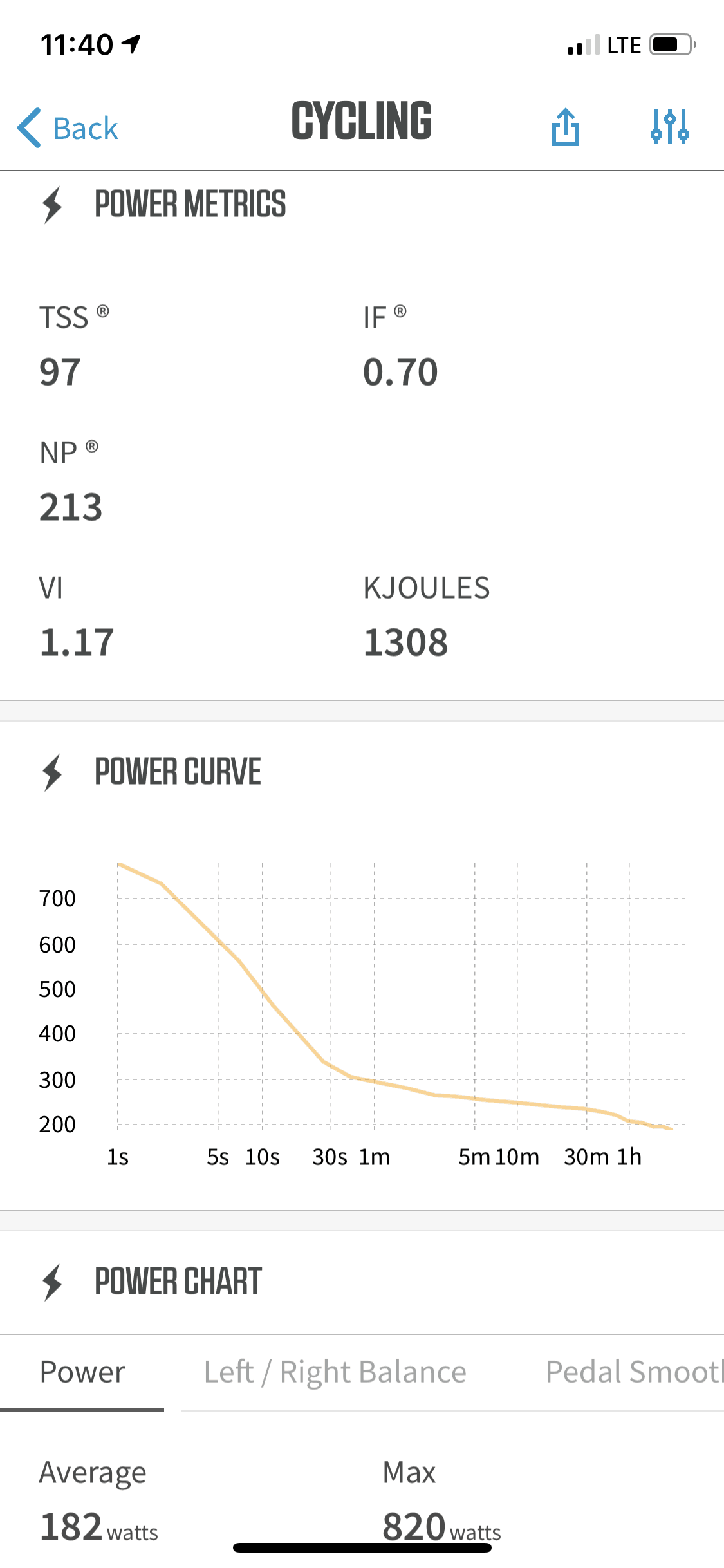
| Power Meter TSS/NP/IF | Yes | Yes | Yes | Yes | Yes |
| Speed/Cadence Sensor Capable | Yes | Yes | Yes | Yes | Yes |
| Strava segments live on device | Yes | Yes | Yes | Yes | Yes |
| Crash detection | No | No | Yes | Yes | No | Running | Wahoo ELEMNT ROAM | Wahoo ELEMNT BOLT | Garmin Edge 530 | Garmin Edge 830 | Hammerhead Karoo |
| Designed for running | N/A | N/A | N/A | N/A | No |
| VO2Max Estimation | N/A | N/A | (CYCLING YES THOUGH) | (CYCLING YES THOUGH) | (No for cycling too) |
| Recovery Advisor | N/A | N/A | (CYCLING YES THOUGH) | (CYCLING YES THOUGH) | (No for cycling too) | Triathlon | Wahoo ELEMNT ROAM | Wahoo ELEMNT BOLT | Garmin Edge 530 | Garmin Edge 830 | Hammerhead Karoo |
| Designed for triathlon | N/A | N/A | Sorta | Sorta | No | Workouts | Wahoo ELEMNT ROAM | Wahoo ELEMNT BOLT | Garmin Edge 530 | Garmin Edge 830 | Hammerhead Karoo |
| Create/Follow custom workouts | Yes | Yes | Yes | Yes | Yes via TrainingPeaks |
| On-unit interval Feature | No | No | Yes | Yes | No |
| Training Calendar Functionality | No | No | Yes | Yes | No | Functions | Wahoo ELEMNT ROAM | Wahoo ELEMNT BOLT | Garmin Edge 530 | Garmin Edge 830 | Hammerhead Karoo |
| Auto Start/Stop | Yes | Yes | Yes | Yes | Auto-pause/restart (but not Auto-Start) |
| Virtual Partner Feature | No | No | Yes | Yes | No |
| Virtual Racer Feature | No | No | Yes | Yes | No |
| Records PR's - Personal Records (diff than history) | No | No | Yes | Yes | No |
| Weather Display (live data) | No | No | Yes | Yes | No | Navigate | Wahoo ELEMNT ROAM | Wahoo ELEMNT BOLT | Garmin Edge 530 | Garmin Edge 830 | Hammerhead Karoo |
| Follow GPS Track (Courses/Waypoints) | Yes | Yes | Yes | Yes | Yes |
| Markers/Waypoint Direction | Yes | No | Yes | Yes | Yes |
| Offline Maps | Yes | Sorta (Maps yes, but technically not routable) | Yes | Yes | Yes |
| Back to start | Yes | Yes | Yes | Yes | No |
| Impromptu Round Trip Route Creation | No (But can create one-way routes from phone app) | No (But can create one-way routes from phone app) | No | Yes | No (But can create one-way routes on device) |
| Download courses/routes from phone to unit | Yes | Yes | Yes | Yes | No (only via WiFi from site) | Sensors | Wahoo ELEMNT ROAM | Wahoo ELEMNT BOLT | Garmin Edge 530 | Garmin Edge 830 | Hammerhead Karoo |
| Altimeter Type | Barometric | Barometric | Barometric | Barometric | Barometric |
| Compass Type | Magnetic | Magnetic | GPS | GPS | Magnetic |
| Optical Heart Rate Sensor internally | N/A | N/A | No | No | N/A |
| Heart Rate Strap Compatible | Yes | Yes | Yes | Yes | Yes |
| ANT+ Heart Rate Strap Capable | Yes | Yes | YEs | YEs | Yes |
| ANT+ Speed/Cadence Capable | Yes | Yes | YEs | YEs | Yes |
| ANT+ Footpod Capable | No | No | No | No | No |
| ANT+ Power Meter Capable | Yes | Yes | Yes | Yes | Yes |
| ANT+ Lighting Control | No | No | Yes | Yes | No |
| ANT+ Bike Radar Integration | Yes | Yes | Yes | Yes | Yes |
| ANT+ Trainer Control (FE-C) | Yes | Yes | Yes | Yes | No |
| ANT+ Remote Control | No | No | Yes | Yes | No |
| ANT+ eBike Compatibility | Yes | Yes | Yes | Yes | No |
| ANT+ Gear Shifting (i.e. SRAM ETAP) | Yes | Yes | Yes | Yes | Yes |
| Shimano Di2 Shifting | Yes | Yes | Yes | Yes | Yes |
| Bluetooth Smart HR Strap Capable | Yes | Yes | Yes | Yes | Yes |
| Bluetooth Smart Speed/Cadence Capable | Yes | Yes | Yes | Yes | Yes |
| Bluetooth Smart Footpod Capable | YEs | YEs | No | No | No |
| Bluetooth Smart Power Meter Capable | Yes | Yes | Yes | Yes | Yes |
| Temp Recording (internal sensor) | Yes | Yes | Yes | Yes | Yes |
| Temp Recording (external sensor) | No | No | No | No | No | Software | Wahoo ELEMNT ROAM | Wahoo ELEMNT BOLT | Garmin Edge 530 | Garmin Edge 830 | Hammerhead Karoo |
| Desktop Application | N/A | N/A | Garmin Express | Garmin Express | No |
| Web Application | N/A | N/A | Garmin Connect | Garmin Connect | Yes |
| Phone App | iOS/Android | iOS/Android | iOS/Android/Windows Phone | iOS/Android/Windows Phone | No |
| Ability to Export Settings | No | No | No | No | No | Purchase | Wahoo ELEMNT ROAM | Wahoo ELEMNT BOLT | Garmin Edge 530 | Garmin Edge 830 | Hammerhead Karoo |
| Amazon | Link | Link | Link | Link | Link |
| Backcountry.com | Link | Link | Link | Link | |
| Competitive Cyclist | Link | Link | Link | Link | |
| REI | Link | Link | Link | DCRainmaker | Wahoo ELEMNT ROAM | Wahoo ELEMNT BOLT | Garmin Edge 530 | Garmin Edge 830 | Hammerhead Karoo |
| Review Link | Link | Link | Link | Link | Link |
And again, remember you can mix and match and make your own product comparison charts over in the product comparison calculator.
Summary:

There’s no doubt a lot of people have been waiting for a color display Wahoo bike computer, and even more for one that has full navigation features. And within those parameters, it technically unlocks both achievements. And it does so with a very cohesive smartphone companion app to boot – something that’s rightfully often praised about Wahoo’s computers. And in fact, that app in the last few weeks got a solid user interface refresh.
The challenge is, I think too much attention was paid to that app – and not enough to the unit itself. But more deeply, I don’t think Wahoo really understands how quick their competitors are moving. When Wahoo entered the market years ago, and in particular with the BOLT 2 years ago, it provided a breath of fresh air. Something different, cleaner, and more cohesive. But now – it just feels out of date. The display and slowness of the unit simply doesn’t match 2019, nor do the feature sets.
When I talk with (numerous) Wahoo employees – I get the impression they haven’t actually tried their competitors units for any length of time. At least not in the last few years. Every discussion I have they talk of slow/laggy cumbersome units of 3-4 years ago (the same time they originally developed the BOLT). But the reality is, their competitors of today are fast and clean (and now the ROAM is slow). Be it Hammerhead, Sigma, or Garmin – the 2018/2019 units just aren’t like your Dad’s units, they’re fast, clean and efficient. And for Wahoo to essentially roll out what amounts to a handful of routing options for a new unit begs the question: What have they been doing for two years?
Of course, the reality is that true mapping navigation is hard. Really, really, really hard. It’s like developing a power meter. It sounds easy in theory, but is super difficult in practice. There’s so much nuance to maps and navigation – be it conflicting data sets, differences in regions, etc… It’s incredibly difficult. So I get that – totally. Which is why I’m astounded Wahoo didn’t add *any* non-navigation new features to ROAM. Something that would have distracted from the fact that the navigation on the ROAM is mostly half-baked still.
While Wahoo has committed to two navigation features for ROAM by June (Strava turn by turn, and on-device elevation data), I really want to see a longer range calendar of features – just like they had back in BOLT/ELEMNT day. They aren’t giving up anything competitive at this point, as Garmin just released their competitors last week. Further, Wahoo is now firmly in the ‘playing catchup’ camp, so they need to figure out a way to convince prospective buyers that there’s goodness coming with future updates.
Hopefully they can do that, and while they’re at it – reduce the price to a feature appropriate $299.
With that, thanks for reading!
Found this review useful? Support the Site!
Found This Post Useful? Support The Site!
Hopefully you found this review/post useful. At the end of the day, I’m an athlete just like you looking for the most detail possible on a new purchase – so my review is written from the standpoint of how I used the device. The reviews generally take a lot of hours to put together, so it’s a fair bit of work (and labor of love). As you probably noticed by looking below, I also take time to answer all the questions posted in the comments – and there’s quite a bit of detail in there as well.
If you're shopping for the Wahoo ELEMNT ROAM or any other accessory items, please consider using the affiliate links below! As an Amazon Associate I earn from qualifying purchases. It doesn’t cost you anything extra, but your purchases help support this website a lot.
Here's a few other variants or sibling products that are worth considering:
(title missing)
And finally, here’s a handy list of accessories that work well with this unit (and some that I showed in the review). Given the unit pairs with ANT+ & Bluetooth Smart sensors, you can use just about anything though.
The Garmin Varia radar alerts you to cars coming up behind you, well before you see them. It's awesome for quieter roads (country roads/mountains), especially on longer rides. It's less useful for city riding. The RVR315 skips the light.
The Varia radar has become incredibly popular in the last year, with most bike GPS companies supporting it (Wahoo, Stages, Hammerhead, Garmin, and more soon). It notifies you of overtaking traffic. While useless for cities, it's amazing for quieter country roads.
Wahoo RPM Sensor
This dual ANT+/Bluetooth Smart sensor will transmit cadence not only to your bike computer/watch, but also 3rd party apps like Zwift, TrainerRoad, and more.
Wahoo SPEED Sensor
Speed sensors are primarily useful for offroad usage. I don't find much of a need for one while road-cycling, but for mountain bike trails they can help alleviate speed/distance issues with poor GPS reception in dense trees.
This is a solid Speedplay-based power meter, which I use from time to time in my accuracy testing of various smart trainers, power meters, and more.
Wahoo TRACKR

The Wahoo TRACKR is Wahoo's newest strap which aims to fix all the issues with older straps. I use it from time to time, and it's perfectly functional.
And of course – you can always sign-up to be a DCR Supporter! That gets you an ad-free DCR, access to the DCR Shed Talkin' video series packed with behind the scenes tidbits...and it also makes you awesome. And being awesome is what it’s all about!
Thanks for reading! And as always, feel free to post comments or questions in the comments section below, I’ll be happy to try and answer them as quickly as possible. And lastly, if you felt this review was useful – I always appreciate feedback in the comments below. Thanks!


Question @Ray (or anyone else who has a Bolt and a Roam)
I use an out front mount on my aero bars and the clearance between the bottom of my Bolt and the bars is fractionally under 1cm. Does the Roam extend at the bottom by more than 1cm than the Bolt (i.e. if you measure from the centre of the mount)?
Thanks in advance
It probably won’t fit. ROAM is considerably larger than BOLT and extends towards the bars as well. I don’t have a BOLT at hand for measuring, but my ROAM didn’t fit on my dad’s bike who uses BOLT for this very reason.
I measured ~5.1 cm / 2 inches from the center of the mount hole to where the ROAM’s corner is during mounting. Hope this helps.
I have been back and forth. I had a bolt a few years back and I loved the ease of use unfortunately the side zoom buttons pulled away causing the computer to malfunction. After some back and forth with Wahoo because it was well out of warranty they gave me a discount for the issue on a new one. In the meantime I purchased a Garmin 520 plus, soon realized why I liked Wahoo so much. The screen is much easier to read and function on the rides. The Strava segment can be easily turned off when riding with Wahoo, Garmin not so much and may risk losing the ride by hitting the wrong button.The ease of changing your screens on the fly even stopping quick on a ride to update what you want. Finally Garmin & Garmin connect need I say more? It was great having to finish my ride go to my computer and manually download files for a week plus, then the issue happens again. Probably or defintley not the last time there system will crash.I know all the LBS by me just carry Wahoo now they stopped carrying Garmin all together. The other issue I have is Garmin’s heart rate monitors are the absolute worst to change the batteries, Wahoo much easier. Sounds like you just don’t like Wahoo. The other reviews I have read have been extremely positive, I purchased the Roam I love it. The touch screen for Garmin is awful because again if you touch the wrong thing you could lose your ride. Just my opinion!!
for 5 years using Garmin almost 30k miles, never even single time I pressed the wrong thing to lose the ride.
I’ve had problems with Audaxing >300km routes with my Roam this is the reply I got from Wahoo support:-
Our head units are optimized to run without any recording issues within around its stated battery life. Once you are recording above this length of time, the chance of recording issues resulting in a reboot increase. Additionally, very large route and ride recordings can be demanding to the operating memory of the head unit. For this reason, we recommend taking the following measures to reduce issues when riding longer distances/times:
Save your route files into shorter “chunks” of around 200km apiece. You can load the next section of route without ending your current ride recording.
Save your ride recording every 12 hours or so, and start a new ride recording at that time. This is like hitting “save” while writing an essay. Afterwards, you can “stitch” together the files using the “File Combiner” tool at fitfiletools.com
Make sure your ROAM has enough available memory. The minimum for proper operation and syncing is 300MB, but we recommend having around 1GB, to leave room for longer rides and future updates.
@dcrainmaker maybe you should test how long competitive gps’s run for :-)
I’ve always previously used Garmin products. I use them for specific training such as steps with set parameters ie 10mins @ 190-250w then 20m @ 250-300w etc etc. Your comparison says Wahoo don’t do on-unit intervals but I’ve seen other posts showing a wahoo with that sort of structure. Do they or don’t they offer this setup? Please clarify if this is different to your comparison of ‘on-unit intervals’. Thanks
Hi Kalvin,
True – the Wahoo doesn’t do-it-yourself intervals on the unit (!). Neither from the app (!) However it does intervals though, but you have to connect it to i.e TrainingPeaks, FinalSurge, 2Peak etc. and create/load your intervals from there. That does work very well, but it’ll cost you each month.
Note that already bought plans from TP can be used without monthly fee. But you can’t change them – i.e. swap two trainingdays…
Thanks Thomas. Does wahoo list all compatible apps or just do some research? I’ve got t/peaks and wko5 but not t/peaks premium
Hi Kalvin,
Don’t know about a list on the web, but if I open the WAHOO ELEMNT app, I can see the following sync options:
– Strava
– Ride w. GPS
– TP
– TrainerRoad
– Relive
– Komoot
– Single Tracks
– MTB Project
– Today’s Plan
– Final Surge
– BestBikeSplit
– PowerTraxx
– Cycling Analytics
– Web¤trainer
– SportsTracks
– MapMyFitness
– MapMyTracks
– 2PEAK Dynamic Training
– Xert
– Google Fit
– Dropbox
I will assume on all the above, that has intervals in their respective programs, they’re synced to the Wahoo and executeable from there. I can confirm TP and 2PEAK and FinalSurge works.
I hope this helps ;-)
Thanks Thomas, that helps heaps
You can still push workouts to your Bolt with the Basic edition of TP. You will only be able to push the workout for TODAY. It won’t load up an entire training plan of workouts. What I discovered is that I had a Premium account and I created a number of workouts. Now that I’m on the Basic account I still have those workouts I created, but I cannot edit them. But I can drag the workout to today, then open the Bolt and click Sync workouts and that workout will show up on the Bolt for me to complete.
I also noticed that the workout will show up on the Wahoo App on my phone too.
Will Wahoo release a new Elemnt this year? Are they on a 2 year release cycle?
My Bolt is running good still, but I will probably get the Roam this Spring and give the Bolt to my wife (the battery on her Edge 510 lasts about 1.5 hours with no sensors attached lol).
I’m thinking after last year that development may have ben pushed back perhaps for both Wahoo and Garmin typical cycle of releases.
Interesting question, I’m watching how it pans out too. Normally I’d be expecting Garmin discounts in early March followed by a Wahoo release later the same month :-) But this year is different of course – the pandemic, the concentration on indoor exercising, and the Wahoo Rival which might mean less attention to their cycling specific devices.
And if Wahoo do update or replace the Bolt, it needs to be a whole lot better than the Roam. As one of the first users of the Elemnt, which was a true innovation, I have been unimpressed by the Bolt (lovely design, but poor screen and useless LEDs invisible in brighter conditions) and even more so by the Roam for the same reasons as DCR has fully described.
And even with a better device, there remain significant deficiencies in the Wahoo software. If you have Di2 the Garmins win hands down for far better support, if you want automatic lap marking by gps position only the Garmins do it, if you want detailed maps for more than your local area the Wahoo doesn’t have enough memory, if you want to configure the autopause speed you can’t do it on a Wahoo, and if you want profiles for different bikes or sports the Wahoo can’t do it.
So – all we can do is wait and see, but to be honest, I’m not too hopeful that Wahoo will both improve their device and deal with the software limitations. Pity, because the original Elemnt could have been a real game changer – but in my opinion Wahoo failed to consolidate on that with the Bolt and especially the Roam.
All so true :-( even the Wahoo cadence fails to wake up after a coffee stop. Will be my last Wahoo I’m pretty sure
PMs also fail to wake up
workaround: press the left side button to go to the sensor menu and press it again a second later to come back to your data pages.
that should be all it takes to re-establish the connection to the sensor (assuming the sensor is awake)
I start my wahoo before a tri race and leave it ticking over in transition, so this particular error is especially annoying to me.
First thanks for your great reviews.
I have a Garmin 945 and Wahoo Elemnt. I have found that the Wahoo shows “glaring” differences on GPS between its GPS mapping and the routes (Strava, MTB); compared to the Garmin which tracks the routes. I’ve done two mountain bike routes recently and the Garmin GPS map history nearly overlapped the MTB/Strava exactly, small turns, sharp turns, etc. The Wahoo looks like its sampling at several seconds, so it smooths out sharp turns and other fine details. On the road with automobile-size-turns both Garmin and Wahoo look the same. On the mountain bike tracks the Garmin follows the Strava/MTB routes nearly exactly whereas the Wahoo is off. This is a link that has a google map with layers–Wahoo ride, Garmin ride, MTB Firebreak, MTB Mtn, Strava Firebreak+MTN. If you look closely at the small turns the Garmin follows the map routes, whereas it appears the Wahoo is smoothing out the ride. link to google.com
548385167%2C-81.13638529510996&z=18
Update. One. I now have a Wahoo, Garmin Edge 530, Garmin 945. I bought the 530 because of disparate readings of Wahoo + Garmin 945. I confirmed the issue. On a hybrid on a road with good clear view of GPS, all three work similarly. However, on a MTB trail, especially in places where line-of-sight GPS might be bad, the Wahoo fails–or, is different than the Garmins, AllTrails, MTB Project, Strava Route. The latter all go together and the Wahoo loses the path and does not follow the published routes. Two. I also have the mileage issue. Wahoo support says that distance, with a speed sensor, is a function of the speed and wheel size. Garmin support says both 530 and 945 are based on GPS position. Garmin’s and Wahoo work fine on my 27.5″ hybrid. But on the 29″ MTB, Wahoo is off Wahoo support says to change the wheel size from “automatic” to the actual size. I’ll try this next. It might be nice if DCRainmaker tested GPS (and distance) in some MTB trails. I realize, as he says, the area around him is like a pancake; and maybe some of the longer trips in Spain or Italy are also line-of-sight. But it would be helpful to see these things pictured in a MTB trail. Third, I’ll try to change the wheel size on the sensor to the wheel circumference to see if that makes the Wahoo work.
Road fit on analyze.
link to analyze.dcrainmaker.com
MTB fit on analyze
link to analyze.dcrainmaker.com
You should always set the wheel circumference manually if you have a speed sensor, and you should always use the speed sensor instead of GPS (as every Garmin device I’ve ever owned has done). Yes, Garmin devices use GPS to occasionally calibrate the speed sensor, but you have no control over when they do that, and they sometimes (rarely, but it happens) get it wrong. Using a manual number just works better and you don’t have to worry about it once you’ve determined the proper wheel circumference. There are any number of places online you can find the circumference for various tire types, and you can always tweak the number if it seems to be off. (Or just actually measure the circumference using a rollout, but I’ve never done that myself.)
Unless you’re manually measuring and going a long distance (with yourself on top of the bike to account for the deflection from your added weight), I doubt you’ll be as precise as automatic calibration. Doing it from standard tire sizes alone is a loose approximation.
GPS is not very accurate through turns or for short distances, but for long straight sections it is. The bike computer should only adjust when the conditions are optimal.
Thanks for the review. Bought the Roam recently without being up to date on what else is needed. Its disappointing that you spend GBP 300 and you cant even create a route to cycle. You need to pay GBP 50 yearly sub to a companion app. The device has a map, and the map is useful combined with the little compass and milometer. But really not good that its not fully functional by itself.
I don’t know if you are referring to Strava routeplanning but ridewithgps works very with my Bolt and it’s free. I think there are others too like komoot that offer free options but I don’t use those myself
Not sure what app you are paying for? I have the element and it has a free app, but not a lot of mapping. I use Strava to create maps, then download via the free app to the device before a rid. It a Elemnt so might be different than the bolt.
You don’t need to pay anything to use a companion app, unless you have a specific preference that needs it…
I use (& love!) cycle.travel for mapping – have a look!
Yes, you can ‘sponsor’ the creator on Patreon (worth encouraging him, I believe!), but it can be used free.
It isn’t rocket science to then open the map to the Elemnt app on my phone….& then chose it to transfer.
ok great, i’ll try. It was the route building functionality i was looking for, so that i could design nice routes (not necessarily the fastest route a to b). The wahoo roam companion app only allows point to point ‘take me to’ routes. and even then it send you down trails you cant take a road bike.
I dont mind paying for premium strava to get routebuilding, but i’ve spent years cycling not wanting to go down the tech route so was hoping this would be self contained in the roam. and at the price i though it definitely would.
thanks for all the suggestions. i will def check them out.
ok am all set on cycle.travel. Its is very good. simple route creator, download and sent to the element app for syncing. I’m sure i’ll join strava some day and start giving kudos out, but cycle.travel is perfect for now. thanks again for everyones help here.
Just FYIm you can use the free version of Strava. The Roam will upload pretty instantly after the end of the ride…you can then edit it so add comments or photos, etc.
I have a pandemic pedal looming in 5 weeks – LEJoG – which was the main reason I got into those months ago, so May pay for Strava nearer the date if it offers any real advantages,,,,
After many years of being Garmin user I bought a Roam. Unfortunately I cannot seem to find the option to display the Average Heart
Rate as a percentage of max. Is this a big miss from wahoo?
I see in some places that the ROAM now supports Trailforks, how does this work compared to the Edge 530?
Hello, question to the users of ROAM computer as I’m considering getting one but can’t find definitive info – did Wahoo update the maps on device itself with elevation data? I.e. will ROAM show me upcoming elevation profile if i use “Take me to…” function to create a route on the device itself? Or it still needs to be a route uploaded from web / phone to get that info?
Thanks in advance!
I was wondering what the difference is in the two different boxes the Roam comes in. One picture above has an all white box and another picture has a two-tone white and gray box. I assume that they are…..different years/different variations of the Roam but I can’t be sure after some short research. I’m looking into buying one that comes in an all-white box but wasn’t sure if there is a big difference from the two-tone box. Thanks.
Unfortunately I don’t see a way to delete this comment hahha…….looked again and realized why the colors of the box are different….. outside is two-tone and open the flap and all white…..smh. my bad hahah……….
I have to admit – I’m giving up on ROAM! I’m going back to Edge 830. There are a few reasons for that, which I will highlight below:
PRO ROAM:
– Very good readability display
– I really like the zoom in/out function
PRO EDGE 830 (and in all these Garmin is better, as I see it):
– Workouts! You can create your own and as many as you want. With Wahoo this requires a TraininsPeaks account. If you pay for for TP, you get good options. But this is not needed on the Edge. It’s free via GarminConnect.
– Better sync options to more trainingsplatforms (i.e. http://www.2peak.com) – workouts are sent to the Edge, but not Roam. Wahoo only sync of trainingfiles. Wahoo works with TP though.
– MTB tracking is MUCH better on the Garmin.
– Segments works so much better on Edge. On can have a complete list on the device and then select which to ride. This requires segment are starred on Strava and downloaded to the unit. But on the Roam you can only have one segment for that specifik route. I have a route with 5 different segments and it’s just annoying I have to decide which to ride before I go with the Roam.
– Zero offset powermeters are way easier on the Edge. You can set a pop-up message on boot-up.
– Edge remote works so nice – especiarly when using your bike computer together with an indoor trainer or on a MTB.
– About indoor trainer, the Edge can connect to the KickrBike using ANT+ and just power. Roam can’t do that and will always connect via proprietary BT and as an FE-C trainer. This gives me issues with wattage dropouts below 60 rpm! (yes support has tried to help me, but issue persists). Edge doesn’t have this problem(!)
– Navigation is equally good – but the on device touchscreen makes it dead easy to use while riding. Yes you can do the same via the phone on Roam. But you then have to stop riding…
——-
I think this covers it quite good. The Edge 839 still has the edge over ROAM, as I see it ;-) The ROAM is a great computer, but the bullets above just are important to me and in this light, the Garmin simpy is the better option.
——-
This is my recap/2 cents after 6 months with ROAM.
Clearly good to have choice, and sounds like you have many reasons to enjoy the Garmin!
Not convinced by your summary assertion that the Edge has the edge: I’d say it is more likely horses for courses. You are the first person I’ve heard who has moved to Wahoo then chosen to move back.
Still loving my Roam – mapping is exceptional; battery life unreal – with cadence and wheel sensors plus the *excellent* Garmin Varia 515 (all of which seamlessly just hook up upon powering on), I did a 60-mile elapsed 6½ hour jaunt last weekend, relying on the mapping, & still had 72% battery life left. Would a Garmin manage that?
(the Varia was reporting low battery, mind!)
For me, the mapping and battery were the key things – I am less concerned about the segments/power etc, but I do understand those who crave that info. Horses for courses, I guess. Strava does give LOTS of post-ride data, but frankly I ignore that.
Could be simpler, but I don’t find it too onerous to move maps across:
Dropbox -> Export -> (scroll down) Open In -> Wahoo Elemnt
Then power on Wahoo, open app, check connected
Workout -> Choose a route -> Click the one just transferred from the App -> Select
It will sync….then start the ride.
Mike. I agree but. See my comments on Feb 11 and Mar 15. Something is off with the GPS on the Elemnt, cf Garmin 945 and Garmin 830. On roads the wahoo and garmins are similar. On MTB trails the Wahoo is noticeably different than the Garmins. The Garmins follow the GPS routes from MTB PRoject, All Trails, and routes created on Strava. The Wahoo does not.
Otherwise there are relatively similar functions/abilities on both Edge and Elemnt.
Curious. Maybe a dodgy unit? Haven’t scrolled to read your experience in detail. From what I have read, if I was off-roading, I’d perhaps try mapping with Komoot?
I can only go with what I have seen – I use cycle.travel for mapping (*brilliant* site – simple, choses great routes), and have perhaps tested about a dozen routes on areas I do not know well, & it has worked great.
It is, of course, nice to have a choice. Quite curious what the Hammerhead Karoo 2 might bring to the table, but planning a LEJoG for me, I needed something decent now (well, bought months ago to get used to it!)
I did a fair bit of research before investing in the Wahoo. Read too many tales of poor battery life on Garmins and people having too many issues. Clearly not everyone has the same experience, if it works for you, stick with it!
A pal of mine used a Garmin for a few years, then moved to a Wahoo and couldn’t praise it highly enough in comparison…..sealed the deal for me, but of course each to their own: like I said, we are not super sporty cyclists desperately interested in split times and performance, but leisure cyclists very much the wrong side of 50, & i nmy case, having one that could do a couple of full days giving decent navigation perhaps without charging was important. To many, that won’t matter a bit.
I agree mostly. I’m nearly on the “right side” of 70 and use biking for exercise. I don’t need precise and detail info, and both the Elemnt and Edge give me as much info as i use.
I also forgot to mention that i have had distance issues with Wahoo on MTB trails that do not occur on road trails. I had the garmin 945 first, and according to garmin support it does distance via GPS, whereas according to Wahoo support the elemnt does distance via speed/wheel diameter. It took me about 5 or 6 interactions with Wahoo support to figure this out, and I still have not resolved this. Both the Garmin’s (945, Edge 530) did the distance on the MTB trails out-of-the-box. I am in the process of figuring out the MTB distance issue on the Wahoo.
This was more than critical for me. The Wahoo underestimated the distance and twice I was at the far end of a specific MTB route that was slightly harder than i should have done, and if i followed the Wahoo distance / map it could have been a safety issue. Instead i followed the Garmin and the live GPS on a phone app (MTB; AllTrails) to find out where i was. Wahoo says this is not a device error, but it was not clear how to fix this for me. Right now i have three devices, use the Garmin 945 for several things, and am comparing the Elmnt vs Edge for mapping.
Re Komot. I think the Elmnt only deals with Strava maps? Download Strava maps directly with the Element phone app. The Edge has Trailfork maps on it already, and i have found it easy to get Strava apps to the 945 and the Edge. Also BTW, the Connect windows program downloads the Strava (and other maps) directly to the Edge, and can download multiple maps, whereas the Element phone apps is necessary for the elemnt and can only have one route loaded.
Anyway its a moot point for me right now. Since i have both the elemnt and the edge I’ll keep messing around with both, it might be that having the Garmin 945 with the Edge is more convenient to stick with the Garmin world.
Indeed both are good units. If I should split 100 points between both units, I’d say in my perspective, the Roam scores 45 vs. 55 to Edge. So both are close to each other ;-)
What I tried to do with my previous post was that if any have the same bullets important as I do, then they should consider the Edge. And just for the info – I do get about 20 hours out of my Edge too ;-)
Do you have a speed sensor? Otherwise, I can’t imagine that Wahoo support was actually right, since the only other way to know the speed is GPS, and once you’re using GPS, why does wheel diameter matter? Just use the GPS distance. Garmin will prefer a speed sensor over GPS, but they also auto calibrate using GPS, so you don’t need to initially input a wheel circumference. (Never a good idea to do it that way; you should always manually input a wheel circumference. They’re not hard to find online, and you can tweak them to match known distances if you need to. Garmin devices occasionally recalibrate, and every now and then get it wrong.)
Hi all,
Love my Roam! Maybe someone knows how I can use tacx smart trainer as source for power and Garmin Vector 3 only for cadence? My impression is, that the power from tacx is better for the ERG-Mode to control the trainer. I want the Garmin Vector 3 only for cadende. If the roam forget the V3, I have no cadence any more. Do I miss something?
Thank you in advance!
Ben
Hi, I hope you can help me out.
I now have the Roam for 4 weeks and I still have issues with the Back-on-track function. It just does not work. I use Komoot for the route. When I have lost my route it keeps on ‘re-routing’ in a loop, with no result.
Does anyone have the same problem? How did you fix it?
PS I have all the latest updates.
This is a known issue. See this post: link to groups.google.com.
Thanks. very helpfull. I deleted all the maps. Now the Companion app says the download fails. (in dutch it calls ‘mislukt’). Do you know what I do wrong?
Not sure how to handle that. You may want to open an issue with Wahoo Support at this point. They’re very responsive.
Hi,
Has anyone else had this issue with uploading rides from the ROAM to Strava? Basically, it doesn’t do it automatically – I’ve got a dual 2.4ghz/5ghz router which works fine, it does auto upload to Training Peaks, and it recognises my wifi. But to upload a ride I have to connect it via Bluetooth to my phone, then in the Element app I have to wait for it to upload, go into the ride, click on the three dots, choose ‘upload’ and choose Strava. Not quite the ‘automatically uploads to paired apps’ claim Wahoo makes on their website!!!!
Has anyone had the same and found a solution? I’ve been in communication with their support for well over a month and apart from the week-long waits for a reply [which I have to prompt], none of their suggestions have worked :-/
Hi David
Yes I have a very similar problem and sorry no answers. if you get one please ping me.
however
1. check you can sync routes from strava/rwgps to your wahoo over WiFi… that should work
2. check you can sync workouts to your wahoo eg from a free training peaks account
3. check you can update firmware over wifi from the wahoo roam’s settings menu
that should all be good and proves your wifi connection is fine. i get all that working too,
like you it seems that I have to simply open the element app for it to sync workouts to the smartphone,
however, in my case, all my ONWARD syncs from the app to strava/dropbox DO work fine and automatically.
i know another person with a wahoo who knows that their workouts are not uploaded over wifi. so its more than 2 of us and this issue has been like this for over a year.
you can try and remove the wifi connection on the wahoo element and add it back but I guess you’ve done that (as have I) and it doesn’t fix the problem. there is a setting somewhere you can fiddle with I forget exactly what it is supposed to do but I;ve fiddled with that too. no joy
i could have sworn this used to work. but for me it could be one of those things where I just inadvertently had it uploading over the smartphone and assumed it was over the wifi.
I just got a Roam! I am a little bit disappointed with the navigation though in terms of its on-the-fly re-routing, given this is a £299 device compared to say £230-260 for Garmin 530. If like me you pre-program a route but then go off course / take a shortcut, it, as you say, tries to take you back to where you left the course! Even if that was miles ago and you are literally about to get back on the road route! i.e. you have a clockwise course and you are about to go back onto it after a short cut, it tries to take you left rather than right … away from where you are going to! They got that aspect really wrong IMO and it reduces the usefulness of the routing which seems to be one of the only things that the Roam claims to have over the Bolt or other devices that are cheaper.
hello
new user of roam
how can i see that the gps is actif for a ride signal gps satelitt ok // message ? sound ?
thanks
great tutorial
hello DC RAINMAKER.
thanks for your in-depth review wahoo roam. just move from garmin to wahoo.
it’s useful review.
I am looking for how to delete workout history from ROAM. even I delete from iPhone app. still can’t delete.
if you know any way to delete my wrong start/stop history. please let me know
thanks
Hello.
What happens to me is the following: Yesterday I managed to use the Wahoo Kickr Core as a controllable and as a potentiometer the 4iiii dual.
I don’t understand why every time I use the Kickr and my 4iiii power meter with the Elemnt Roam I have to link the 4iiii because it disconnects from the Roam over and over again every time I turn off the Roam or Kickr
Any solution?
I know this is an old post but has anyone else experienced Grade Lag on their ROAM? Example: I can see a rolling hill approaching and I know I am going up hill but my ROAM doesn’t register anything on the screen. Also I will start going up a hill and the ROAM won’t register a grade change on the ROAM for 50-75 yards up the climb.
Am I the only one having this issue?
I experience the same delay, but in navigation itself. I ride slow, like 12 mph, and I’ll turn onto a road, following the prompts on the ROAM, and the ROAM always thinks I’m about 40 feet from where I actually am. I reported this to Wahoo way back, and they sent me a new unit, but the new unit does the same thing. Perhaps the GPS chip in the unit isn’t “dialed up” to ping the satellites too frequently to prevent excessive battery drain? I assumed an eventual firmware update would fix this, but not so far.
That being said, I still like the unit; although it is the first and only one I’ve owned. For me, the lag is only an issue if I have to do a lot of tight turns onto different roads.
I have the ROAM and a Edge 530. 1–i have had the grade lag on the ROAM and the GPS issue. I think the GPS issue is due to a fixed 1 s update. 2–i have a grade lag on the Edge, but no GPS; 3–In an earlier post on this thread, i described the Edge vs Roam issue on the GPS. The Edge follows map routes nearly exactly (e.g., MTB project), the Roam is off. 4–Some of my issue was due to the Roam needing a wheel size and a speed monitor, but not all. 5–I like the map display for a programmed route on the Roam, but not the inner details. I use the Edge for all the routes i ride regularly, but when riding a new route, use the Edge for details and the Roam for the map display
I’m curious about the blacked out data fields. Mine does not have that and it would be nice if I could set that up.
Great info. I just got the Elemnt Roam and wondered how DC Rainmaker got to the screen on the app in my attached file. This is just after the beginning of the Navigation section. It has “Routes” at the top, with “create Routes” below. Thank you very much Bryson
Open up the Wahoo ELEMNT app, then on the bottom left side is the Workout tab, and then you should see routes show up there (once connected to the unit).
Thank you for the prompt reply. Look forward to your imput. How do I send the $20?
How do I save a searched location (s. attachment) ? Is an active Internet connection needed for ALL take-me-to route functions (cross-hair on Roam and smartphone app starting point to end-point route search function ? Thanks again M. B. Rogers
Thanks for becoming a DCR Supporter!
I don’t believe you can save a searched location, however, you can:
A) Create favorite spots to save: To do so, on your unit, choose the ‘Save my Location’ option from the menu (left button), which then saves that location
B) Route to an address
C) Create a favorite via the app itself. Choseo to ‘Route to address’, and then tap somewhere. When you do, you’ll see an empty heart the bottom. That becomes a favorite that shows up on the map as a favorite location
Trying out an active internet connection, it does appear to be required for the ‘Take me to’ when done from the phone itself. However, if you’ve saved a location on the unit (or, from the phone using ‘C’ above, then you can route to that without internet using the Routes option no the ROAM itself. Basically, go like you’re going to select a route, and then choose the Take me To option, and you’ll see saved favorites.
Cheers!
This nugget is important … and rings true. I’ve had a Roam for a while now and for me, it’s the most irksome aspect and makes the rerouting feature something that can’t be trusted, unfortunately
‘In general it appears that (for at least my roads/routes) Wahoo is more strict in trying to get you back closer to where you left the route. Whereas Garmin appears to take the approach of ‘we’ll catch-up somewhere down the road’.
Well said, Jim D…exactly right. Personal vent: My biggest complaint regarding reroutes is that you need only be on the other side of a 4 lane road for it to trigger. I’ll be heading in the right direction, I can see the bike path on the other side of the road, but ROAM goes crazy — it derails some of my rides because I become too distracted and angry with the device. It would be nice if there was a way to tell ROAM to only think it’s off course if you’re more than a configurable number of feet away from the route. In my case, probably 300 feet or so.
I thought this would get fixed through firmware updates, as I’ve had my ROAM since 03May2019, but it’s still broken.
In short, if you want true navigation, like for deliveries or something, Roam is NOT a good fit.
I’ve turned off rerouting in ROAM. This allows me to still see the planned route, but make my own decisions on how to get back onto said route. ROAM no longer goes crazy. I know this is not ideal for a navigation device, but I’m much happier now.
Automatic rerouting will always be close to not good enough, because the device can only reroute based on what the map knows. And the map won’t know about spontaneous road closures and the like. When you can’t follow the route, chances are you also can’t follow the re-route suggestion and the device UI should be carefully designed to not be detrimental to the rider getting creative based on the situation they see on the ground. Keeping the original course on the map should certainly be the minimum.
The Garmin map UI already has some support for multiple routes at once. E.g. the difference between the geometry of the path loaded,which might be full of GPS errors, and the map-following version thereof created during the infamous “calculating” stage. But also the difference between primary route and whatever it calculated when you hot [yes] on navigate to start. But I’m not saying that Garmin is already as good as it could be, far from it.
One possible improvement that comes to mind: it would be super nice if it would keep the primary course in the background when starting a “pin drop” navigation. That wouldn’t just be a tool for more tricky re-route scenarios, it could also serve mow positive situations like “I know a nice cafe we’d miss by a few miles”
Hey @ray (or anybody) – Do you know if – in the time since your original review – Wahoo has added the ability to scroll the currently-showing map (that you showed you could NOT do at 10:50 in the video) – e.g. somewhat akin to the location setting function you *could* do at 9:40 in the video?
I’ve got an original Wahoo Elemnt, the lack of this feature has always bugged me. I’d pop for a Roam IF that feature existed (now). But if it doesn’t, I have insufficient reason to buy something new.
Any info?
To go short; would not buy again! I did my research, but alas this is not the device for me. Luckily I got it with a discount, but still. I went for a state of the art navigation system, but this tends to be a computer, that does navigation at the side. Although it does this quite nicely, its not flawless and most of all YOU MUST HAVE A SMARTPHONE. (And I don’t). You need it when on route, otherwise it’s a very limited device, regarding navigation. When your expecting somewhat of a TomTom experience, forget it. Furthermore, Wahoo’s marketing really is misleading! Colors aren’t nearly as brilliant as in the pictures, the beezel of the screen really is a lot bigger than in the pictures! Oh, and don’t expect an odometer on the device itself. It’s not there. (Great review btw.)
Odd for someone to splurge on a Wahoo Roam yet not own a smartphone 🤷♂️
I maintain I t is a brilliant device, having used mine for a 19-day, 1,090mile LEJoG, “Iron-to-Iron” as well as many dozens of local day rides….but yes, it is not like Waze where you pop a destination in and go.
Works great with the amazing Garmin Varia too (but avoid the camera one – see DCR review to learn why!)
Dick, Mike. See my way-earlier-posts re the Wahoo. It does not do mileage. I started with a Wahoo element and Garmin 945 watch. I had conflicting readings on mileage and elevation. Garmin Watch, MTB project maps, and Strava Routes, all agreed; Wahoo element was less in miles and variable in elev. I bought a Garmin Edge 530, and both Garmins, maps, etc, agree. Last week i rode on a Strava Route i made. Garmins both said 7.9 and 449 feet; Wahoo element said 6.7 mi and 499 feed. Garmins matched the Strava route. I contacted Wahoo support about thsi and they gave me several suggestions i tried, and none work. I now use Wahoo for the map display and rerouting.
Mike, I didn’t know the meaning of “to splurge”. It looks like you feel a bit offended, being a Wahoo fanboy. And that by someone who doesn’t even own a smartphone. How does he dare? Is that what you mean to say?
Unfortunately I think you don’t see my point at all. I am not into smartphones, Strava, Ridewithgpx, Komoot etc. I certainly know my way around in the digital world. But this is not what I was looking for. And most of all, I am not happy with a device that needs another third party device to do what I want it to. For that kind of money.
Update on my previous review. Being somewhat negative about the Roam earlier on, I now must say that its not that bad a device after all. In this YouTube video below, there’s a comparision with a Garmin 530. Watch it for yourself. I have come to the conclusion that overall the Wahoo Roam is the winner. And I have to live with the knowledge that still nothing is perfect…
link to youtu.be
See my note on September 12. I could send you the three fit files for the last ride, Garmin Edge 530, Garmin watch 845, Wahoo Roam I also could send you links to several tests I did for the three. Maybe DC Rainmaker can compare them in the field.
Here are for DC Rainmaker comparisons. On a couple the Wahoo does not start mileage until 6 min in the ride. On others it starts at the same time. This could have been my error. When it starts at the same time, check the difference in mileage. On the recent trip a couple of weeks ago, it was 1 mi in 7 miles. I’ll see if I have the files and load them.
link to analyze.dcrainmaker.com
link to analyze.dcrainmaker.com
link to analyze.dcrainmaker.com
link to analyze.dcrainmaker.com
Are you using a speed sensor? If so, have you checked the circumference calibration on each device?
I tried this with:
No speed sensor.
Speed sensor with default wheel size
Speed sensor with measured wheel size
I went on and on with both Garmin support and Wahoo support over this. I don’t think Garmin uses the speed sensor, and apparently Wahoo does. But setting it to the wheel size did not fix this.
I have not checked the calibration on each device.
Additionally, i think the speed sensor wheel circumference is in the Wahoo and not in the speed sensor, and i think it was set for all speed sensors rather than specific. I have two bikes i use, with different wheel size, so this was an issue also.
Also, I’m not really complaining, but people should be aware there are “issues” with Wahoo, even if it is the default wheel issue. My two Garmin devices show the same distance, AND, they are the same as the Strava/MTBProject/ routes. The map things on the Wahoo are far superior to Garmin–display, reroute, etc. Garmin’s routes spend most of their time telling me to do a u-turn.
Garmin absolutely uses the speed sensor over GPS if one is available. You always have to be careful with Garmin, though, since if you’re using automatic calibration using GPS Edge’s will recalibrate at random times and occasionally get it wrong. It’s always much, much safer to use manual calibration so that the number never changes. There are sites on the web that will give you circumference information for various tire sizes, and you can always tweak it if you find it a little off. If you have two bikes, you should have two speed sensors, They’re not really made for sharing. The sensors usually don’t know the wheel size (the new Garmin sensor that records on its own might). It’s the head unit that does the conversion from wheel rotation to speed/distance and they base it on which sensor they’re connected to.
I bought a eMTB back in April. It’s a mullet, and when I got it I didn’t know offhand the circumference for the real wheel (where the speed sensor is), 27.5″ x 2.6″. So I let my Edge 830 calibrate using GPS the first time I went out. I then forgot to go back and switch to manual calibration. So a few weeks ago I was 20 miles into a 36 mile ride when I noticed that my speed was awfully slow, about 1/3 of what I knew it was likely to be. Gradients were also larger than I knew they were. So I got home, checked the sensor calibration, and sure enough it had recalibrated to around 1/3 of the actual circumference. I switched it to manual calibration and have had no trouble since. I’m not familiar with the ROAM but I’ll bet Wahoo does something similar. So the moral is to always, always manually calibrate.
Paul. Thanks for the suggestions. I have separate speed sensors on the two bikes. For sure i have not set the speed sensor manually, or checked it, on the Garmin’s. Both garmins are nearly identical to Strava routes i have made, or to MTB Project routes i have followed. All three (garmin’s, Strava) when loaded together have routes right on top of each other, and the same distance. I’ll probably take your advice/instructions and work on this.
I looked at my config for Wahoo and did set the wheel circumference. Wahoo also has another issue that i could not get to work. The GPS map result for the Wahoo is significantly off from the Garmin’s and the Strava/MTB routes. At one time Wahoo support told me it was my fault (i did not wait long enough for the GPS to settle, but i tried this) or the s-by-s rather than “instantaneous” GPS (ditto, set the Wahoo and the Garmins as close as possible), etc etc etc. I have concluded after a couple hours of support contact and emails that I’ll just stick with the Garmins for distance, effort, work, etc. I have ridden about 30 new routes in the last 12 months and always use the Wahoo for the map.
But every time I’ve seen a screenshot of an ELEMNT, there are no street names, no route numbers, no POI’s, no identifying names at all. So why use a Wahoo for a map? Or am I wrong about that? To me, no identifying context == no map. An Edge 530 definitely has real maps with context.
The Roam (V1) is now selling for around € 130!
I guess thats a really good bargain, and if im not wrong, it is not very different from the V2!?
After using this unit for almost 3 years, and I just realized there is some removable plate on the mount. What’s the function?
I love my wahoo computer. But there’s a problem they haven’t been able to fix for almost a year. If you have a rotor inpower crank, you cannot adjust the crank length properly.
I change the value on my Roam device and on the app also to 175mm, then press calibrate and after calibrating the crank lenght is automatically set back to 172,5mm. This happens all the time and it seems like the 175mm value won’t be saved. I also tried to set this in the Wahoo app, but there it seems like it can’t be saved either since it switches back as well…