We continue our exploration of New Zealand roughly in the same southerly region that we left off at, departing from Queenstown.
From there we drove a couple hours deeper into the mountains towards the Milford Sound region, staying in Te Anau (pronounced tea ah new). This is a tiny little town on a lake with easy access to everything in the region (well, except late night food).
A Little Boat Ride
Our first morning there we headed up super-early, well ahead of most tourists, into the massive national park. Our goal was to drive the few hours deep into the park and catch the first boat of the day at 8:50AM.
The drive was through stunning scenery, but for most of it, the weather was clouded and rainy. Perhaps one of the more memorable (visible) pieces was the tunnel – which wasn’t like a typical tunnel where the starting and ending elevation are the same. Nope, this one descended downwards – and quite steeply at that…and with road quality that might qualify as ‘off road’. Oh, and it was only 1.5 lanes wide. And since we were prior to 9AM…it was a free-for-all.


At either end of the tunnel were these large birds which simply hung out, waiting to toy with tourists. Except, in this case The Girl got to take a long stream of photos as one of the birds played with a beer bottle that someone else had left behind.

But…back to our planned boat ride. You board one of many available boats for a couple hour cruise around the sound, which on a sunny day would allow you to see the 5,000+ foot peak that’s not entirely visible in the picture below.

So instead, we focused on things closer to the ground…like the water. Which, as you can see, is astonishingly clear:

And the green moss is also incredibly bright:

A number of times we got escorted by Flipper and his friends:

And I certainly can’t forget the seals either. They pretty much just barked and jumped around, entertaining themselves just as much as us.

The boat also got us rather close to a number of very high waterfalls, like the one below. And by ‘close’, I mean, directly under. A few seconds later, we were in the waterfall.

After getting back on dry-ish land (still raining off and on), we made our way back out of the park, stopping to take in a few short hikes, as well as anything else that looked pretty. Examples being the river below, and the wild flowers. This was a brief moment of random sun:


After getting back into town that evening, we went out for a run…at 9PM at night. The totally awesome thing here is that it doesn’t get dark out until 10:30PM. It’s amazing.

A Long Hike
The next morning we woke up again early (seems to be the pattern as of late) to catch a water taxi off to a remote beach across the lake. From there we’d hike about 7-7.5 miles up to the top of a 5,000-6,000ft tall mountain (Mt. Luxmore), and come back down again – all in about 14 or so miles.
The first couple miles of the hike is basically just through deep forest, like the below. For fun, we took along a few Garmin Rhino’s that we’d been lent, and had loaded up some of the GPS tracks of the hike on them, though, with the path as well marked as it was – getting lost wasn’t really going to happen.

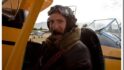
At this point in the journey, everything is warm, relatively dry, and smiley:

Eventually we broke out of the trees and across some high meadows, about half-way across this picture we added some clothing layers, as the winds were pretty nasty (at least 20-30MPH):

About 30 minutes later we came across a really well maintained hut, where campers could stay over for the night. Also of note, is that we started down at the lake in the back of the picture.

Here’s us…using the camera timer technique…with the camera just being a bit too close for my height:

Around these parts, things started to get a bit more cloudy, wet, and windy:


And…some snow was thrown in for good measure:

About an hour after we left the shack, we finally hit the top of the mountain. Though, with the winds and rains howling – we certainly didn’t stay long. Here’s proof of the top though:


We were both pretty hungry by then, and found a little couple yard section that was sheltered from the wind by some rocks. In that section we enjoyed yet another peanut butter and jelly sandwich. I can’t really keep track of how many of these we’ve had this trip – but we’re on our second loaf of bread. It’s a little concerning.

After we got to the top we quickly retreated back down. In pretty good time in fact. There may have been some solid trail running the last few miles. In fact, this route is used as part of a 60KM trail run race each year (in December). All in it took us about 6hr and 15m including about an hour of stoppage time for pics/food/etc… With the total mileage being 14.3ish miles. I think it was a bit longer than that though, since I think this cut a few corners deep in the trees compared to a Garmin unit The Girl was carrying (which was showing about .3-.5 longer, before it ran out of juice).

And finally… the (warm, sandy) beach, and boat back home:

More sheep, wanderings around Wanaka:
Last but not least, a collection of photos from today, as we wandered around the Wanaka area, mostly just exploring a 35km dirt road out to the middle of nowhere (apparently where they filmed Lord of The Rings, but I actually haven’t seen that yet).


I continue to find it interesting that they farm deer here. Nothing wrong with that at all (Venison!), just one of those things I’m not used to seeing.

Also not at all used to seeing this many sheep:


The road twisted and turned through the farmland – so cows, sheep and everything else routinely wandered across the road. This cow as just chillin’ by the side of the road:

And finally…
Dear Avis – I can’t yet at this stage apologize for (all) the things your trusty little car has pushed through/over/under/around…mostly because I still have two more days left, both of which involve canyons. But I can say that I haven’t hit any sheep, cows or goats…yet. Which, given everything – you should be happy with. And on the bright side, the car is looking pretty clean after today…
Signed,
Me

Thanks for reading all, and hope your enjoying some of the travel posts! I’ll keep mixing in regular sport stuff, but since this blog has always been about my little corner of the world, and this happens to be what’s going on in my world…it’s what I end up posting about.
And fear not, I still have more to come. Aside from the aforementioned days in New Zealand, we’ll actually be celebrating New Years day twice…both as one of the first, and last, places on earth. Crazy! Any guesses where?
Have a great weekend!
FOUND THIS POST USEFUL? SUPPORT THE SITE!
Hopefully, you found this post useful. The website is really a labor of love, so please consider becoming a DC RAINMAKER Supporter. This gets you an ad-free experience, and access to our (mostly) bi-monthly behind-the-scenes video series of “Shed Talkin’”.
Support DCRainMaker - Shop on Amazon
Otherwise, perhaps consider using the below link if shopping on Amazon. As an Amazon Associate, I earn from qualifying purchases. It doesn’t cost you anything extra, but your purchases help support this website a lot. It could simply be buying toilet paper, or this pizza oven we use and love.


Beautiful Pictures!
Hawaii?
You guys are heading over to Samoa next?
Any prizes? =P
Your as good a travel writer as you are a tri/gear writer! Trip looks awesome.
Hey Ray,
I’m loving your NZ reports. I used to live there so it’s great to see some of your photos.
Btw – the bird you have a pic of is a Kea, the world’s only alpine parrot. Ask some locals to tell you some stories about the kea – they are very smart ( and mischievous!) birds.
I saw you in Wanaka yesterday (Friday Dec 30) walking around town but I was too shy to yell “Hi!” to you too. Hope you’re enjoying what Wanaka has to offer, only the best place in the world!!! :)
nice. 6:15 out of your MotoACTIVE. good thing they updated the firmware!
You’ve been living in the Mid Atlantic too long! Seattle is further north (47N) than Queenstown is south (45S), so days in late July in Seattle should be as long or longer than late December days around Queenstown.
DC is only at 38N.
Gorgeous pictures! I wish I was there!
Those are some fantastic photos.
Welcome to New Zealand, but you have missed the spectacular and wildly rugged West Coast – you will have to come back again! BTW the bird is a Kea, it has been rated as the most intelligent animal species over and above the dolphin. Congrats on the wedding :)
Awesome pictures and report. I love the mix of travel with tech…actually the travel makes me incredibly jealous, but I’ll survive! Enjoy the child-less freedom!
@2, Melvin, Can’t be Somoa anymore, link to timeanddate.com
They are now one of the first to see in the new year.
Somao and American Somoa will be on different sides of the IDL. Great pictures, BTW.
I love all the pictures Ray! It looks like you are having an amazing time there, makes me want to go :)
Welcome to our side of the World Ray. You’ll have to jump the ditch a bit more and hit Oz one day. Keep enjoying NZ, one of the most beautiful countries in the world.
Those are some great photos! Did you see any Hobbits or Dwarves yet? They’re filming the new LOTR movies there now – you should check it out and see if they need any more “extras”.
Ray,
link to lh6.ggpht.com
I can’t believe you are actually using the Wahoo Fitness app!? That app is so unreliable. Half the time it never displays data, it is collecting but not displaying. Also, the GPS tracking is terrible. It has the potential to be awesome. Like the ability to upload data from a select few Garmin watches. They really need to increase the number of watches supported. Also, it is awesome that they have included so many options for uploading fitness data. However, there are so many other better options.
-Nicholas
Have you tried it lately? It’s been going mile for mile beeping and talking at almost exactly the same spot with my FR610. I too thought it wasn’t displaying data until I realized its the second page you want.
Either way, I was actually using it for a specific reason. ;)
Next week…
Hi Ray, great to see you enjoying my homeland. I love going back, usually make it 1-2x a year. Always interesting to read an ‘outsiders” observations.
Also I have to thank you for my Xmas pressie. My wife knows I read you most days and went and did her research appropriately and voila – there appeared a Garmin Edge 800.
Can I also add a suggestion for a post – I know you use SportTracks & Garmin Connect & Training Peaks. Surely then you have perfected a routine for keeping them all in synch. I find this a real mess, I’m sure I’m doing something wrong.
Cheers
Keith
Hi. What’s the GPS watch you’re using here? I don’t recognise it and I love the look of it! Thanks.
Re: Krumbling Kiwi, I would also like to 2nd your request for a post on syncing workouts to multiple sites.
Hi Kiwi and Nathan-
Good idea! I’ve just added it to my list. In general, my workflow is that I let the Garmin ANT Agent sync the data to my computer, and also to Garmin Connect. I do this as it provides a ‘backup’ of my data just in case something happens.
After that’s complete (happens basically automatically after plugging in my USB stick) – I then open up Training Peaks and upload my workout there. That’s my authoritative location for training data.
I don’t typically sync into Sport Tracks very often anymore, mostly due to time constraints. I do wish there was a plug-in for ST to simply sync from TP…that’d be awesome!
When I do use ST, it’s because I’m looking to do something that TP can’t do, or am using one of the add-ins.
Hope this helps!
Oh, and the watch I was using was the Motorola Motoactv.