I’m currently at 34,999ft cruising over the Atlantic, nearing the coast of Newfoundland. But prior to that I was home in Amsterdam for the weekend – however, much of last week I spent in Chamonix, doing a bunch of meandering around the Alps. I’ve spent virtually every waking hour the last (and this entire flight too), working on the 21 product-related posts and videos that’ll convene starting tomorrow and for the following 10 days. However, I suppose I should at least show you some of the awesomeness that is the backdrop for UTMB coming up later this week.
So let’s dive into some of my time those days. Note that I often escape to Chamonix for testing devices. I’ve got a long history of things I’ve tested here over the years from a variety of companies. From drones to action cams, watches to bike computers, and accessory for all everything else. While Chamonix can be incredibly expensive at peak winter holiday season, it’s actually rather inexpensive if you’re not paying for a lift ticket and just go with last minute hotel deals.
It’s a mere 65-minute drive from the Geneva airport, which is only an hour flight from Amsterdam (and Paris before). And it’s got tons of variety in terrain that’s unforgiving on both humans and devices. But today it’s about devices. For that, you’ll have to wait. Instead, it’s basically about pretty views.
Hiking to the Glacier:
I landed early morning in Geneva and after spending 45 minutes getting my rental car (with only one person in line) I zipped up to Chamonix and straight into the parking lot near the main Aiguille du midi cable car. I had no intention of using such cable car (been there, done that). But it floats right above the main trail up that side of the mountain.
My plan for day 1 was to hike up to the glacier, also known as Mer de Glace. I assumed it’d be about 9-10 miles (15KM), at least according to route planning. The route could roughly be divided into three chunks. The main climb with an average of 20% gradient, initially in deep forest and then the tree line occurs and it gives way to alpine meadows. After which you traverse forever, followed by the last chunk of a climb and then a descent to the glacier.
The trees were nice and quiet – with virtually nobody around. I think I only saw 3-5 people on the way up.

I did see one guy descending down trail running at unreal speeds, clearly training for UTMB. And by ‘training’, I mean, tapering for his plan to win. I’ve never seen someone run so fast on trails before, let alone descending across rocky terrain. Like gliding on air.
Shortly after that point, I arrived at a chalet near the midpoint of the mountain at about 2,310m. A short hike away is where tourists shift between two different tram systems to get to the 3,842m (12,604ft) peak adjacent to Mont Blanc. It’s also where lots of folks then do hikes across the traverse section to the glacier, taking the train down.

I had lunch here on a random rock. I had picked up a few things at the village grocery store:

After that, I made my traverse across for a couple of hours. This was a bit slow going, mainly due to slow people. I did find though that by switching over to trail running, people got out of your way quickly – so I did that in sections. Versus if you were just hiking fast, they didn’t move out of the way.

Finally, I reached an overlook down to the glacier and valley below:

Now – at first you might presume the glacier is only the white part and gone. And while it’s true that global warming has mind-bogglingly shrunk this glacier over even the few decades, most of what you see in the above photo is glacier. It’s simply covered by dirt and rocks from landslides on the side of the hills. In fact, as I stood in this very spot a big land-slide came crashing down from the right side, complete with a huge plume of dust that lingered for a while.
That said, once you get down to the train station they have photos over the last few decades showing how much the glacier has shrunk – even one dated from August 30th – mere days difference, but a few decades apart (thus to compare summer to summer). Looking at the above photo, the glacier used to be another 100-150m deeper (so all the way up to the green parts), and numerous kilometers longer. We’re talking entire sky scrappers taller here in depth.
My goal was to get down to the glacier, but first I had to sans-chairlift ride. But it appeared those trails were closed. The route I initially went dead-ended unless you had climbing gear. Perhaps there was another route I didn’t see, but it didn’t appear so. You can see the chairlift base though down below, where skiers (like myself a year or two ago) can get out of the glacier at the end. But it also serves to get people down to the glacier. I didn’t want to go down that badly.
Just to illustrate how big the glacier is, start with this photo – which is already zoomed in:

Now see that blue splotch? That’s actually blue carpet where tourists can go inside the glacier. Think of that carpet roughly akin in size to the carpet at the finish line of a race. Now let me crop in again:

Now you can see humans on it. Now scroll back up twice to realize the gigantic size of it. Here’s a photo I took a few years back with my brother skiing on it. See the bottom of the ski lift up there (half-way up there!), that’s the level of where the ice was just in 1990, compared to where I’m standing.

The 2003 level, in case you’re curious, is about 2/3rds the way up to the lift. Meaning, it’s disappearing faster and faster. Another great story on it here with more photos.

In any case, at this juncture, I could have hiked back down to the base, probably another 2-3 hours. Maybe 60 minutes running. But I had a much longer hike planned for the next day – and if there’s one thing I learned is that it’s not the hiking up that kills your legs: It’s the going down.
Given I live in a place that somehow has less elevation gain than a sheet of paper, I knew that if I did the descent on day one that my legs would be immediately shot for the rest of the week. So instead, I took the nifty train back down:

It takes 20-25 minutes I think and brings you right back to the village. Perfect! Total stats for the day were 9.13mi/14.7KM and 4,613ft/1,406m of elevation gain. Here’s the Strava activity.
The Entire Ridgeline:
The route I was most excited about was a much longer hike the next day. This was slated for 13 miles (21KM), with a crapton of elevation gain over non-ideal terrain. It’s funny, as a road-runner I see 13 miles and my mental-math running calculator says 1hr 30min to 1hr 45mins, donezo. Except, that’s not trail running time. Nor is it time dealing with thousands of feet of elevation. Nor dealing with ladders or rock slides.
In any case, I walked from the village and zig-zagged my way up under the gondola, as I’ve actually done many times before – both running and hiking. I started from below the UTMB start/finish banners, which were being put up for the race later this week. Check out my past post on spectating that, it’s incredible.

Once I reached the first plateau about 90 minutes later, I would begin my transition from easy walkable terrain to less stable stuff. It wasn’t horrific, but it wasn’t fast going either.

At this point, you’re still actually ascending, working your way up to the top of the pinnacle looking ridgeline, just weaving in and out of all sorts of rock slides, cliffs, and other things that would hurt to fall on.
Eventually I got to my lunch spot for the day – overlooking some lakes. There were a number of folks here enjoying lunch as well, also, some goats down below. Most would turn back at this point, as the trail gets considerably more difficult and there isn’t another ‘exit’ for about 10KM (due to chairlift closures this summer). So you’ve gotta commit.


It’s shortly after this point that I was super glad that I picked up new trail running shoes at Decathlon. I know, they aren’t fancy or a major name brand like Salomon, but they worked for how little I’ll use them. Worked really well.
Wait, you’re confused on where the trail is? It’s in there. Again, don’t fall.

(The trail starts by holding onto the metal railing on the left, it then wraps around the cliff/rock where eventually it connects to the rockslide where you can make out the faint etching in the above photo of the switch backs.)
A few hours of silence later, I arrived at my main goal:

Super pretty spot, complete with a chalet to get things to eat if you wanted. In my case though I still had a few more hours to go I figured. So I didn’t stay long.

Instead, I began my slow descent back down. A descent that would include all sorts of ladders:

Some like the above were pretty tame, whereas others like below had numerous ways you could have things go horribly wrong quickly. I was pretty glad it wasn’t raining out, or snowing (a legit concern even in summer). I had packed gear in my bag for both though, just in case. But that doesn’t mean I wanted to deal with it.

Just to put things into perspective – I came down the middle of that mess below. You can try zooming in, but yes, that ladder is actually angled sideways. Thanks for asking.

Finally, some 7.5 hours later I descended the last switchback and was back down in the valley – albeit many miles from where I started. So I walked across the street and took the train back to the main village:

Total stats for the day were 13.3mi/21.2KM and 6,225ft/1,897m of elevation gain. Here’s the Strava activity. I would strongly recommend this hike – it was super cool. There are ways to make it easier and avoid the ladder situation, fwiw. I would not recommend this hike on a rainy or icy day though. It’d be miserable.
A Swiss Quickie:
For my last act, I wanted something a bit shorter. Not because my legs were on fire (surprisingly, they weren’t horrific), but because I would set aside much of the afternoon for final filming. I generally prefer this to be my last thing, specifically around the ‘A-roll’ (the parts where I talk). Whereas I usually collect b-roll constantly. For the video I edited today, I’ve probably got 50-60 minute of b-roll captured and I might use maybe 5-6 minutes in total. Maybe, at best.
In any case, over to La Tour I went. This resort is at the end of the valley and is one of my favorites. None of the mainstream tourists go here (either summer or winter), with it mostly being locals. They have some great mountain biking, and also a lot of great open terrain for drone testing. I’ve tested numerous drones here over the years.
I created a route that basically was straight-up, and then along a ridgeline before a dip down and then ascending back up to touch Switzerland. I got off to a slightly later start than I expected due to some conference calls, which is of note later on. In any case, up I went:

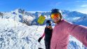
The reason I wanted this specific trail was actually to get some ridge running shots on the upper edge. And this would have been an epic route for it. But alas, by the time I got up there, there was just too many people around for my desires. I prefer to fly drones when nobody is around or within earshot (for a variety of reasons). So instead, I just got some selfie shots.

Or proper Instagram style, looking all stoic like off into the distance. Or something.

Turns out the ground is covered in small blueberry plants. Well, the plants aren’t so small, but the blueberries are. Roughly like the size of green peas. I picked a few like everyone else, but it kinda fell into the ‘not worth it’ category. You’d spend forever getting one tiny handful of blueberries.
From there I headed back up again, this time to Switzerland, and towards the chalet at the top:

It’s here I got the lunch of champions: Coke & Snickers. I normally have Diet Coke, but they were all out. :(

The guy at the table next door was rocking an old school FR405. Props man, props!

This point at the top near the chalet is a bit of a major crossing point, and there’s tons of different ways you can head from here. It’s also the border of France and Switzerland. There’s no border control here though. You can go back and forth a million times if you want, albeit with a passport stamp.

I know, some people (as in, all people) were getting beer or wine up here. But I figured it’d be less than ideal if I got drunk before starting all my filming. My luck I’d have it totally out of focus, mics turned off, and somehow upside-down. Or I’d forget half the things I was supposed to talk about.
It’s alright, I’ll catch-up on that front once Eurobike & IFA are over.
With that, I did the first half of my filming up top for an hour or two, and then I took the chairlift down:

I could have easily taken the trails down (which are very tame here), and actually some awesome fairly nice trail running routes to get back down that aren’t super technical either. Just sorta gliding down. But I didn’t have the time for it. Here’s the Strava activity though! Some 10KM gaining 3,229ft/984m of altitude.
Once down at the base I spent another hour going and shooting photos and b-roll for a variety of products. Then it was a quick jaunt back to the hotel to use their pool shower facilities before zipping out to the airport. I got there in plenty of time: They were just starting boarding. Anything more is wasted hiking time.

With that – thanks for reading, and hold onto your hats for things to get a bit busy around here
Have a good week ahead!
FOUND THIS POST USEFUL? SUPPORT THE SITE!
Hopefully, you found this post useful. The website is really a labor of love, so please consider becoming a DC RAINMAKER Supporter. This gets you an ad-free experience, and access to our (mostly) bi-monthly behind-the-scenes video series of “Shed Talkin’”.
Support DCRainMaker - Shop on Amazon
Otherwise, perhaps consider using the below link if shopping on Amazon. As an Amazon Associate, I earn from qualifying purchases. It doesn’t cost you anything extra, but your purchases help support this website a lot. It could simply be buying toilet paper, or this pizza oven we use and love.


Which shoes from Decathlon?
These ones here. :)
They were 69EUR, and if my Decathlon matching skillz are up to date, it looks like the Kalenji XT7’s: link to decathlon.co.uk
No pictures include your wrist, my Fenix 6 spider sense is tingling!
Hah, my thoughts exactly!
At this point we pretty much all know it’s gotta be the Fenix 6. Makes me kinda sad, that me F5+ doesn’t sit at the top of the food chain anymore…
Great minds think alike
Not too long to wait according to Garmin (Portugal) themselves!
link to youtu.be
August 29, 12:00 PM.
Hi dcr,
where is your Fenix 6 series hands on? As I have read/seen in the Garmin Forums, the F6 series in online on the Garmin homepage.
Sorry, but have to leave that comment:
Flying from Amsterdam to Geneva on one hand and discussing disappearing glaciers on the other is a little bit inconsequent.
Otherwise a very interesting report also when not bike-related. ?
Cheers
Yup, that’s fair. I’d note that we don’t have a car and bike everywhere. In the rare event we do use a car-sharing car, it’s electric).
As noted below – I’m more than happy to entertain suggestions for legit altitude that are easy to get to by train from Amsterdam. The challenge I found when doing research is that the logistics fell apart pretty quickly when you actually put numbers (hours) to the train schedules and connecting trains into the mountains.
Things will get better in December, they are opening a new train connection from Geneva towards the alps (notably Chamonix could work :) ). Train would be Amsterdam – Cologne – Geneva or Amsterdam – Paris – Geneva. And let me know the next time you are in Geneva, there are more things to see than the airport and a nice lake for swimming! (Writing this from a train to Geneva)
I did have a quick look: Thalys (high speed train) from Amsterdam to Paris, then Lyria (another high speed train) to Geneva; total travel time 7 hours. Compared to roughly 3 1/2 hours total (my guestimate) for airtravel.
Didn’t look at prices, but wouldn’t be surprised if the train is significantly more expensive (unless you book 6 months in advance).
On the other hand, those hours between Amsterdam and Paris / Paris and Geneva are not “wasted”, good opportunity to read / write / code etc.
Still, I can sympathise with choosing going by plane with this difference in travel time.
It would be interesting to know how much CO2 you have released in the atmosphere over the last years, Ray.
Just to put it in perspective: earthwide CO2 emissions are currently at little less than 5 metric tons per capita per year. Your current transatlantic flight alone emits between 1 and 2 tons of CO2 per passenger (depending on the locations you are traveling from/to, wind and the type of plane you’re in). What do you think where you are situated when it comes to CO2 emissions (worst 0,01% of the planet’s population or even worse)? With all we know about global warming for many years now, staggering for a father of two…
You can’t have it both ways Havelaar.
You can’t ask for details on accuracy of devices in the comments sections of dozens of reviews for your frequent cycling trips down to the Alps and Pyrenees as you have over the last 5-6 years of comments, and then complain about when I go test such devices in those conditions.
Not one single trip to Pyrenees or Alps required me to fly. Trains (especially night trains and admittedly on rare occasions a rental car) did perfectly the trick. No own car anymore for over 16 years now, no more flying at all (even if it takes a few hours more by train, so what?), meat or fish only twice a week. Some of us try to change their lifestyle and, as far as I’m concerned, it becomes more and more difficult to cope with the public promotion of a lifestyle like yours.
If it’s too much to ask to see influencers like you travel less (why hop between continents all the time?) and by train instead of plane and, as you put it, I cannot have it both ways, than I choose the planet over details on accuracy of devices. Thank you!
Flying is way more fuel efficient than a passenger car, fwiw.
Bashing planes seems to be en vogue at the moment.
Euro trains are far more efficient than any other transport.
Yeah, I would also be interested in your thoughts regarding the CO2 footprint with all that flying all the time. And how that CO2 is being compensated or limited? There are other means to attend meetings and events these days, so flying is not always necessary anymore.
Problem is that flying is just too damn cheap, especially from Amsterdam Schiphol Airport. That is why train and other alternatives are often not used even on relatively short distances, like Netherlands Switzerland.
So, my question to you Ray is: do you consider your CO2 footprint? Do you know how bad flying is for instance? And do you think about how can you limit it? Or do you just enjoy it while it lasts? (Since you have children, I don’t think you do that) Compensating CO2 is not enough anymore I am afraid…. Changing one’s behavior is what counts.
PS I am writing this from Amsterdam where we have the second heatwave this summer with record high temperatures
Yup, definitely consider it. After all – we don’t own a car and bike everywhere (cargo bike and all).
Unfortunately, there isn’t really a practical high altitude location to test devices from Amsterdam. For example, getting to Geneva (gateway to many places in the Alps), would take 8-10 hours on train during daytime, and 13 hours at night. Plus another 1-2hrs to get up to the actual mountains.
As for not attending events – I actually turn down a lot (most) of events. I don’t like them anymore than anyone else does (seriously, most media don’t really like going to events).
I’m more than open to alternate test locations from Amsterdam that have legit altitude (drop them below). It was easier on the train from Paris with the TGV to Geneva, but from Amsterdam that’s not practical anymore.
Why do you require high alitiude to test new devices?
Maybe the hills in Limburg in The Netherlands, (2-3 hours away by train/car from Amsterdam) or hills in “The Ardennen” in Belgium (2-3 hour car ride) are high enough for testing:
link to nl.wikipedia.org
link to nl.wikipedia.org
Unfortunately, certain functions that I test/validate require various altitude thresholds, none of which are achieved in the Netherlands or Belgium. This is across multiple watch vendors and functions.
For example, something like the COROS Vertix requires an altitude of 2,500m before any form of high altitude SPo2 alerts will trigger. Same goes for something like Garmin’s Forerunner 945 with altitude acclimation (lower threshold), or the Fenix 5X Plus with SpO2 related metrics.
On all Garmin edge devices, I had, I remember that I could manually calibrate the altitude, simulating a much higher or lower altitude than were I physically was. That should trigger the thresholds and enable testing.
I just can’t believe that in 2019 you have to physically travel to a place of 2500m to trigger a function. Does the Garmin development center reside at 2500m? Do you know how they develop and test these kinds of functions? You are familiar with the possibility’s developers have with developing software and simulating stuff.
I believe you have more than enough real high-altitude experience to test a device on lower grounds and simulate the height and still be credible. And save the planet…
Oscar, give the guy a break!
Have you thought about your carbon foot print on every reply and post you read?
Go after the big guys if that’s what you want to do!!
If there was a ‘like’ button this comment would get it.
Really…? He is a Sports-Tech blogger (mostly) who is also more eco-conscious than many others. Therefore no reason for all these accusations! You can take up this sort of discussion with a eco-blogger, if you really must.
“On all Garmin edge devices, I had, I remember that I could manually calibrate the altitude, simulating a much higher or lower altitude than were I physically was. That should trigger the thresholds and enable testing.”
Unfortunately, that wouldn’t really solve the issue. And ultimately, that’d just be faking data. The reality is that out of the numerous devices from five companies I was testing, all are designed for the mountains. That’s part of testing them. Elevation (and all the variations that are driven from it) is a core piece of these watches. I’m looking at things like drift over time, whether it gets the correct elevation to begin with, and whether the total ascent/descent numbers match both reality and reference points along the way. Every posted elevation market I wrote down and took photos of all the devices.
There’s a time and a place for simulator and such, but ultimately simulators are designed to work well – and consistently. It’s specifically why I don’t use cycling simulators for testing power meters and trainers. They don’t emulate the real world. Just like elevation simulators don’t emulate sweat build-up inside altimeter ports that often challenge so many watches. And they don’t emulate mud either. Nor do they emulate the actual changing weather conditions and whether or not a unit tracks that.
Further yet, some newer devices can now lock to the map elevation (DEM) points and leverage that. Again, all things to validate and find quirks with. For some of these devices released in the last year, the elevation driven features are fundamental to why people buy them – such as ClimbPro on the latest Edge 530/830.
If we switch to drones for example, how drones track up/down mountains has long been super challenging for sports-driven products and features (like ActiveTrack, or AirDog/Staalker/etc…). Often times they won’t properly ascend/descend past various points unless manually overriden – defeating the purpose of tracking.
And finally, on action cameras mountains are awesome at exposing humidity type condensation issues with removable lenses – especially if there’s rain or water and big temperature swings. Let alone features that depend on elevation tracking and potential data overlay smoothing that defeats the purpose of such functionality (an area that certain companies have failed at in recent years).
Hey Oscar:
You can purchase some Carbon Offsets for Ray if you think he is flying too much… read this for some tips.
link to nrdc.org
When I say this comment I meant Guy’s.
Do Garmin, Polar, Suunto reveal how they beta test their products?
Hi Ray,
There’s a night train (with sleeping facilities) from Dusseldorf to a variety of places, amongst them Innsbruck.
From there you can take a bus to Stubai Glacier, or train to Several ski resorts.
Simulation from Amsterdam:
Tuesday 10 September 2019, changes: 1 – Travel time 15:10
18:38 2b Amsterdam Centraal ICE 221 20:46 16 Düsseldorf Hbf
8 minutes transfer time
20:54 20 Düsseldorf Hbf EuroNight 421 09:48 7 Innsbruck Hbf (At)
Price:130 euros
Google OBB nightjet for more information
I think Ray’s decision to go without a car buys him out of the fifteen hour train trip–thirty hour round trip–plus bus to get to the mountains.
The only people suggesting 30 hours of train travel for a three day trip are the people who would never do such a thing themselves. I’m about to hop on a 15 hour flight to South America, I suppose I should have really considered taking a 4 week sailing trip there, instead.
I’m going to sleep well knowing that everyone on here scolding others about carbon footprints has personally given up refrigeration, hot water, television, automobiles, all packaged and transported food, television, and air conditioning in their homes and workplaces, and that they are currently commenting from a bicycle-powered recycled 386 computer, using a low power dial-up connection.
Location for fenix 6 review?!?
It’s a pity that UTMB implemented a point collecting system for all races. I mean, athletes must run another registered ultra trails before they apply at UTMB… I would like to do once the Courmayeur Champex Chamonix (CCC), but within this system – no chance…
Greetings Ray with my photo attached…
Given the popularity of those races I feel the point qualification system is unavoidable. Chances to get in even with enough ITRA points isn’t a done deal and it would be much worse without those requirements. I’m curious what’s keeping you from attaining the required points. At least in Europe there are plenty of races awarding them and you need 6 from 2 races. That’s not too difficult if you have the fitness to accomplish CCC.
Hi Florian,
In neither sporting discipline, you can not make the same applicable criteria for the amateurs and for professionals. Time and money-wise these groups are uncomparable.
My week consists of 4 working days 12 hours shift and then 3 days off. My shifts are scheduled in November in advance for the upcoming whole year, including vacation days. Within this lifestyle, I am able to manage 5-6 triathlon races/year. Amateur athletes are paying, professionals are being paid just for the registration. I visited Chamonix several times and also Aosta, the Italian side, and for this reason, the CCC would be an emotional selection.
Timewise I was unable to even visit Ray on his regular cave invitations (X-mas or Easter), however, since I am his hardcore reader I always wanted to… On the other hand, I offered him the role of supporter on one X-tri event I am attending on 8/31. but he is in NY…
Now translate all the above-described circumstances to chasing points on 10 races just for the attendance on the desired one…
Ps.: and the postcard for you…
You need 6 points from a maximum of two races over two years for the CCC, so I don’t understand why you’re talking about chasing points on 10 races. The points are for completing the race within its own cutoff, if you don’t DNF you’re good, there’s not much chasing involved.
You’ll be pushed to find a trail 100k that doesn’t require you to show recent completion of one trail 50k as an entry qualification, just to demonstrate you have the skills and can attain the fitness for it.
I sympathise with the demands of your job, but I think you could qualify if you wanted it badly enough, and the experience in qualifying would be valuable for the day.
I agree with Florian, getting into those races if it was just by ballot would be even worse.
Hi Dom,
Thanks for the clarification. I think I misunderstood the pointing system,…
I thought I must collect the points within 2 consecutive years to apply at UTMB, where participation means 1 point and being in top 10 more, or on the podium much more. That would mean 6 races/year to earn the 12 points…
Even the official site (link to utmbmontblanc.com) doesn’t contain this info…
And by the way, when they first implemented the CCC, it was without this pointing system and it worked fine…
It’s there, but not on the front page – look here which is from menu – runners – qualifying races.
It’s way easier than you thought it was. The points are the same wherever you finish in a race, and depend on the length and ascent (and a little bit on terrain difficulty), explained in a bit more detail here on the ITRA site. You can get 6 from two flattish 50 mile races, or two 50k with a bit more climb in them.
The CCC started selling out stupidly fast in the first couple of years, from what I can make out. Ultra running is really growing. The North Downs Way 50 miler in the UK sold out in about 4 hours for 2020, and I won’t be surprised if it’s more complicated than first come first served for 2021.
The “Diet Coke” on the lunch picture doesn’t really look like a “Diet Coke”. It even has “Original Taste” written on it. Am I missing something? Maybe my “joke detector” is broken?
I was wondering the same thing ?
Nah, just my inability to finish a thought. I had wanted Diet Coke, but they ran out. I rarely drink regular Coke – and forgot how incredibly sugary it is.
Well, they did warn you right on the can: “Original Taste”
(Personally I can’t stand diet soda of any kind, but I don’t drink the regular kind, either.)
Ray, my only problem is the selection of a Snickers bar. Milky Way is the better choice with Diet Coke!
I’ve been watching Greta cross the Atlantic on Twitter over the last few days, absolute kudos to her but it’s also vivid evidence that flying is the only current realistic solution to long distance travel.
For my own part I try to do what I can. The next car will be electric, I try to make ethical buying decisions (renewable energy suppliers, carbon neutral produce, etc) but ultimately I also still fly.
Trip looked great Ray, looking forward to seeing the reviews drop over the next few weeks. Hopefully that may take some of the froth off the 945 pricing and I can upgrade..
..
Hi Ray,
There are night trains from Dusseldorf to Innsbruck.
From Innsbruck, there are quite a few ski resorts available by train.
You can also take a bus to the Stubai Glacier, bit more than an hour trip I think.
Tuesday 10 September 2019, changes: 1 – Travel time 15:10
18:38 2b Amsterdam Centraal ICE 221 20:46 16 Düsseldorf Hbf
8 minutes transfer time
20:54 20 Düsseldorf Hbf EuroNight 421 09:48 7 Innsbruck Hbf (At)
Also google OBB Nightjet for more info.
Airtraffic makes up 2.69% of the global CO2 Emissions. While it’s true that there are trains going from Amsterdam to Chamonix, it’s simply not a viable option for a short roundtrip – especially for a father and husband. And also: where do you think the energy for the trains comes from? Coal-fired power plants in south germany? Nuclear plants in france? Is that even better for the environment?
If you want to cut on CO2 emissions ask yourself if you really need that new smartphone, laptop/tablet, smarttrainer or wearable or if you can get by with your current gear like the guy with the FR405. Yes, we should have a discussion about the environment. But please keep it real. Ray is doing his job which involves travelling to places, testing gear so we don’t have to “order and send back” (which btw is also not environmental-friendly). Inform yourself on this blog or elsewhere and make wiser buying decisions instead of pointing fingers.
anything about the new garmin fenix 6 series ? or still under NDA until launch at IFA ?
saw that some guys steal the start: link to winfuture.de
Hi Ray
Big fan of the site. Enjoyed the post around Chamonix (my home town for 20 years), if you fancy climbing Mont Blanc as a “Random Thing” (or testing some gadgets out up there, you can take a drone in June and September for example) give us a shout, I’m sure we could sort something out for you.
Thanks for the post. While it’s true we all have to pay attention to our CO₂ foot print, I find the bashing here misplaced.
I hope a lot of the testing involves the F6, so that we get more than a “quick hands-on” video by next week. Really looking forward to the bigger display and—ideally—the solar version testing.
Hi Ray. I got a new Garmin Marq Expedition. Have you done any trekking in Expedition mode to showcase the function and battery use.
No, not yet. It’s tough because realistically with only single-hour checkpoints, you’re really talking weeks of desired wandering to make it make sense over something like UltraTrac.
Hey Ray, 2 comments here. FIRST, a big shout-out to Clever training UK. They have amazing service, even for delivery to France. Just bought the Forerunner 945 from them. SECOND, pretty cool to see you in the Alps, just spent my summer hiking, road cycling and MTBing there. It’s fantastic.
Thanks John – appreciate the support via CT UK!
I like the CO2 focus, but we need to make small changes that have a big effect, not big changes that have a small effect like the 30h train trip mentioned.
I don’t know if people are aware, but shifting your pension money to focus on low CO2 investments has almost 20x more impact than a package of lifestyle changes. And it’s possible to halve the CO2 footprint of a portfolio without hugely changing the risk/return of the portfolio. Talk to your employer or financial advisor.