Last week I embarked on a trip to hike across the Portuguese island of Madeira, which sits about 500km off the coast of Africa. It, alongside the Azores, are often referred to as the ‘Hawaii of the Atlantic’. I had a few product/post/video-related objectives for the hike, some short-term, some longer-term. One of those included testing out the new Polar Grit X2 Pro on treks that it’s ostensibly designed for, while putting it up against a slate of watches in the same category.
Starting later today I’ll post my usual daily onslaught of Instagram stories covering the trip over on my Instagram thingy (I simply didn’t have any energy, cell service, or battery life to spare, to do so at 11PM each night). And then eventually I shot an entire pile of video footage about it, that I’ll attempt to edit together. But, I know if I wait till I finish that, I might never post this. Thus, here ya go.
If you’re looking at doing something similar, hopefully, this helps in some capacity. Or, it’s just fun to look at pretty pictures.
The Planned Route:
For my route, I simply started with the famous MIUT (Madeira Island Ultra Trail) race route. That race occurs here in a few weeks in late April, and is brutally difficult in terms of elevation gain, some 7,090m ascending (and the same descending) over the course of 115km. Here’s the official MIUT map:

I selected this route for two reasons. First, was that it was a ‘known good’ route. Not having been to the island before, I wanted a route I knew would be passable, and with known-good GPS/route tracks for it. There were numerous Komoot and Strava variants of the route, all looking near identical (a good sniff test that something is legit established). The route has changed a bit over the years though, so keep an eye out for which variant you’re choosing.

The second reason I selected the route was that it was overwhelmingly scenic, without being touristy busy. Outside of one short 6KM section, and then another field of trees, I basically saw nobody the entire time. For context, the first day I saw three people on the trail. The last day, I saw one hiker, and a few mountain biker groups later in the day.
Still, I did tweak the route a bit, with the goal to end up a bit more northerly, rather than in Machico. Practically speaking there’s way more hotels in Machico, making it a better end-point than my plan below. Note that in this variant of it, I added a boatload of walking at the end (right side) in case I wanted extra mileage, to go as far as one could possibly go.

For resources, two sites I found helpful to sketch the bones of the trip was this company that organizes trail running tours, and then this blog that had done some thru-hiking. The 3-day trail running tour is roughly the idea I most closely followed. The key difference there being they handle all your hotels/gear/etc, and you get to just run/fast-hike. In my case, I carried all my gear, and still attempted to fast-hike.
Speaking of which, my plan was to carry a tent and camp. That does require permits (which are free). However, finding permits for the sites you want on the dates you want, can be tricky. Annoyingly, basically, every campsite I passed was dead-empty (even when they said they were full). There are huge signs at the airport and everywhere indicating a 1,000EUR fine if you wild-camp. That said, if one simply asks to use a friendly farmer’s land – then it’s totally OK. There are TONS of places one could camp legally, with just being friendly.
And finally, for drone flying, that too requires boatloads of permits for each and every day/flight, which I also painstakingly got (and that’s beyond also having an EU license for whatever drone class type you have).
Ok, with that, let’s dive into it!
Day 1: Porto Muniz to Rosario

The night before starting my hike, I got a taxi from the airport to Port Moniz (where I’d start the hike). The taxi takes about an hour, depending on how scary fast your driver goes (and costs about 80EUR). Meanwhile, I left my laptop/other bags at the airport, which is a mere 4EUR/day in the luggage storage room they have there. Perfect!
The next morning sunrise wasn’t till 8AM, and while I had planned on starting at sunrise, the best plans get a bit behind when it comes to starting more than half a dozen devices (something Des and I recently talked about in this episode). I ended up starting around 9AM, and by time I got properly underway at speed, it was closer to 9:30AM. The first portion of the trek is along the coastline, on what is basically an abandoned road. Technically you can drive on portions of it, but almost nobody does because the surface is sketchy and full of falling rocks. That said, it was one of the prettiest sections on the island.

From there, I headed past a campground and started inland a tiny bit, following one-lane residential roads that etched their way up the sides of the mountains. It was initially just lightly misting, but the rainbows made it clear that rain was inbound.

I’d continue climbing for a bit, eventually arriving in the jungle. Here I’d often be next to a levada, which lets the water run along the path, eventually getting bigger and bigger as it reaches the valley floor. That said, while climbing straight up, it was also just a lot of steep switchbacks. You can see the route map on the Polar Grit X2 Pro, indicating just how many ups and downs this route had.

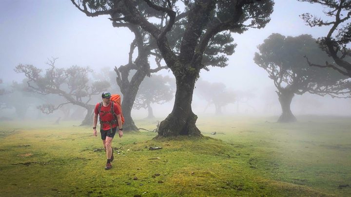
The rains had increased by now, along with the denser cloud cover – but if there was one place you wanted it, it was while arriving at Fanal, which, worked out perfectly timing-wise.

This is often one of the more touristy spots, but you can’t even tell, given the density of the clouds on this day. It was perfect! Later the next night I’d show some of these photos to some photographers who had arrived a few hours after me there, and they were quite jealous of the bad weather I got. Else, it’s kinda just trees in a field.

After getting more shots of wet trees than I ever really needed, I continued on. Instantly, it went back to desolation. Also, lots and lots of mud.

Eventually, I’d descend out of the clouds down a steep switchback section for a few kilometers, losing the 800m or so, and gaining a number of waterfall photos.
From there the sun came out, and I was in a brief valley on a road for 1-2KM transiting to the next climb – arguably the biggest climb of the trek. Komoot has it at 1,221m in about 4KM (or 4,005 in 2.5mi). Again, remember my pack is about 43lbs/20kg.

The initial climb was pretty brutal. I had thought I’d find lunch/real food somewhere down in that valley – but none was to be had. So while I was operating well on Precision Fuel & Hydration gels, part of that fueling plan included real food in calmer sections. Sadly, wouldn’t end up happening till 11PM at night.
In any case, up I went, eventually getting above the trees and into some high-brush area where I’d climb a bit more, but what was effectively atop a plateau of sorts. The sun was slowly fading on me when I arrived at this ridge line. By this time I hadn’t seen any human in many hours, but I just kept dutifully following the routes loaded on my watches.

Still, it’d end up being one of my favorite spots of the entire hike. With nobody around, and the sun setting behind me, I got some spectacular shots (mostly video), for later.

I then spent another two hours descending down the steep 20-30% declines in the darkness, the mud from earlier still very much part of the scene. Obviously, taking a lot of photos in the dark doesn’t work out much. I had a headlamp of course, so it wasn’t a big deal. Here’s the last photo I took as I put my headlight on:

The main challenge I had for the evening was simply lack of food. I had planned to eat dinner in the town of Rosario, before finding a friendly local to let me sleep in their field (my campsite reservation was for many hours/miles back – but since I couldn’t find food for lunch, I also didn’t have food for dinner). At 10:30PM, nothing was open for dinner, and knocking on people’s doors didn’t seem ideal either.
So instead, I hitchhiked a ride a few kilometers to the nearest beach town from a friendly man and his 7-year-old son. It was here I found food still (barely) open for the night, and a place to crash. The next morning, I’d simply take a ride back to where I left off, to continue.
The first epic day was done though, with more than a marathon’s worth of mileage. One thing to note is that the moving time doesn’t include all of the stoppage time, including the endless setting up cameras for the videos I was shooting/etc…
After downing as much food as I could stomach, I fell asleep hard.
Possible route tweaks on this section: If I was doing this again, and needed to shave off some mileage, I’d likely cut off the section approaching Seixal where it dips south a bit. Instead, I’d go from Fanal/Pedriera, and then take the trail that appears to go straight towards Seixal, then from there continue back up along the route as planned. While this southwards diversion was perfectly fine, it was mostly just generic jungle. Thus, you’re not really missing out on swapping one shorter jungle section for another longer jungle section. Additionally, I would likely explore ending at São Vicente, where there are many more food/hotel options (especially if arriving late). I’d probably do this by choosing a trail that ended specifically there.
Day 2: Rosario to Pico do Areeiro

On the second day, I got myself a quick ride back to where I left off on the trail and began immediately going up. Essentially, the first hour of the day you spend going up to a small town where there’s a tourist shop with plenty of drinks (and trinkets). This is a relatively quiet jungle trail, but looked like in busier tourist seasons it might not be so quiet.

The store was great though, because they had food and plenty of water/etc to fill up. I’d strongly recommend filling up here, because once you leave this tourist shop, there’s nothing all the way to the refuge at Pico Ruivo. That’s many hours of nothingness (in terms of water/food). There are a handful of very tiny streams that cross the path, but even on this day after heavy rains, your best option would have taken many minutes to fill a single water bottle. I know that 11.2km might not seem very far away, but with the frequent rapid ups/downs (with stairs/ladders), it was slow going.

After leaving the shop behind, I climbed more – in total this interrupted climb is about 1,200m or so in ascent. However, once you reach the ‘top’, you basically end up traversing a ridge. In fact, it’s this section of the route that I deviated from the MIUT trail, which was otherwise going back down to the valley floor and back up again (for what is normally an aide station/medical/etc…). Here’s the alternate Komoot route that I followed for Day 2.

My assumption for this traverse was that it’d be ‘easy’, and in some ways, it was. The trail is well-established, and I saw a few hikers every hour (and plenty once I got to Pico Ruivo). This section of the trail would be amazeballs if I was trail running or with a lighter pack, but, there’s still a surprising amount of steep ups/downs/ladders/etc that don’t show up well on maps. None of it is super challenging, but keep in mind there’s no meaningful shade here (you’re above the trees), so it’s a lot of hours of baking in the sun. Still, it’s super pretty!

A bit before 5PM, I arrived near the refuge for Pico Ruivo, and also the very short climb up to the top of Pico Ruivo (the highest point in Madeira). This out-and-back climb takes only 5 minutes, but for many, is the pinnacle of their day hike. Depending on the time of day, this platform overlooking the surrounding area can be pretty touristy, but it’s the highest point you’re gonna get in Madeira at 1,862m (and 3rd highest in Portugal).

Here’s a potentially unpopular opinion sidebar: The summit itself isn’t actually that amazing. Rather, it’s the route *to* the summit that’s where all the goodness is. Said differently, if you’re doing a day-hike on this route (which is typically Pico Ruivo to Pico do Areeiro), and you’re tight on time/weather/etc, skip the summit. Just go roughly 3-4KM out from Pico do Areeiro, and then turn back and go home. That honestly gets all the best parts (tunnels, cliff-edge walks, stairway to heaven, etc…), and all the best views – without the bigger climb up to Pico Ruivo. Especially if the crowds are heavy.
In any case, my summit was complete, I headed to the refuge to grab some quick drinks/food. They don’t serve any sort of substantial lunch there, rather it’s just things like chips/drinks/etc. They do however serve dinner there if you’re staying there the night. You can’t book online, but you can call to book. It sounds like it fills up rather quickly. Also, critically, they have free water out front.
From there it’s about 6KM to Pico do Areeiro, and this section of trail is by far the busiest. It’s the one that virtually every tourist does, because the views are incredible. It’s not super steep, but does have some short up/down sections that can be messy in bad weather with a big pack. But overall, I was just a bit tired by this point in the day (now about 6PM). Still, this is some of the best scenery of the entire trek!

You’re up against cliff walls spanning thousands of feet, somehow etched into the rock, occasionally going through long tunnels in the rock.

It’s really absolutely amazing.

There’s a good reason why so many people do this section as a day hike. About 2 hours later, I got to the base of the Instagram-famed Stairway to Heaven section. There was nobody there. In fact, I’d spend another hour there tooling around taking photos over sunset – with only one or two couples briefly passing through. It’s hard to convey how mind-boggling this is. Earlier in the morning, I’m told the lineup was 20-30 minutes to cross through this section.

This portion of the hike is less than a 1KM from the main parking lot areas and reasonably accessible, thus tends to be very busy. So busy that the next morning I’d see thousands of cars lined up to park for miles here for the trailhead. I was told by a few others I saw on the trail that it was taking 5hrs that morning to hike between Pico do Areeiro and Pico Ruivo, due to the heavy crowding on the trail.
Me? Nobody. I had the entire trail section basically to myself. Obviously, it wasn’t due to time of year, but rather, time of day. Every guidebook/site/etc says to “get there early”, which, everyone does. People start arriving at 5AM (sunrise was at 8AM). It’s insane. However, come 6-8PM (sunset was at 8PM on this day), the place is empty. There were a mere 10 cars in the parking lot when I finally finished. Seriously, if you want to hike this section, simply go up there around 3PM, then hike across to Pico Ruivo (arriving there around 5-6PM), then turn back, getting back around sunset. Obviously, adjust offsets slightly for sunset times.

After my own Instagram photo shoot, I decided I should finish before dark-dark for once. From there it was a short and sunset-filled hiked the rest of the way to the ball (Pico do Areeiro). As noted, by time I got to the parking lot, there were less than 10 cars there.

Now, the only itty-bitty challenge was that the camping location I had reserved for the night was another 8-10KM downhill. I actually didn’t mind the idea of having to descend down that bit, however again, I was without real food (and now 9PM). The Portuguese restaurant near the camping spot I had planned to eat at would close in an hour, and I certainly wasn’t going to make it 10KM in the dark in under an hour. Obviously, I had assumed I’d get here substantially earlier.
So, I made friends with some German photographers who gave me a lift down (and again, I’d double back up in the morning). I’ll say that hitchhiking on the island was astoundingly easy. Every single time the first car I asked/passed stopped. And everyone was friendly. Or, I just looked so ragged that they took pity on me. Who knows. But what I do know is that the restaurant hit the spot.

After eating and hiking 500m or so, around 11:30PM or so I finally got to the campsite in the dark to set up. Sleep came quickly.
Possible route tweaks on this section: I actually wouldn’t tweak much in this section. It was largely great, especially with my adjusted route across the ridge.The only thing I’d do differently would be for the long traverse leaving Encumeada towards Pico Ruivo, would to be simply carry more water. I wasn’t in the danger zone, but was rationing water more than I should have been for the last 1-2hrs till I got to Pico Ruivo (where there is water). And this wasn’t even a crazy hot day.
Day 3: Pico do Areeiro to Porto da Cruz

The departure from the tent this morning was anything but graceful. I basically rolled myself like a burrito across the ground to the nearest tree, in order to find something to stabilize myself to actually stand up. But once I got the legs moving and warmed up, they weren’t too bad.
So I packed things up and headed out to the road to get a ride back up to Pico do Areeiro, so I could resume where I left off. While the route I’d take would eventually pass back directly by my tent (literally, right past it), I wanted to leave off where I started. Once again, the first car that passed, a very friendly couple from Poland, picked me up on their way to their day hike along the Pico do Areeiro to Pico Ruivo section. I learned along the way that he’s very afraid of heights/drops, and she very much not. I’m curious how that hike went.
I ended up hiking up the last 1km to the summit, because the parking situation was so bad, I have no idea how far back down they had to go to find a spot – I’m guessing 2-3KM by the looks of it (again, it’s insane in the mornings). I decided to grab some late breakfast at the visitor center, before heading out on the trail. My legs were resigning to their fate: Descending down 6,000ft to the ocean. Thus, they argued to at least feed them. Fair enough.
Here was (just a tiny slice) of the car lineup, as seen zoomed all the way in from the top:

This entire descent is pretty tame, especially the first few kilometers, which is mostly just slowly rolling downhill. There was nobody on the trail again. Despite starting at the busiest point on the island, everyone was going the opposite direction. So once I left the visitor center, it was beautiful, calm, and desolate.

Eventually, I passed my campground and then continued descending. Soon I’d see trail running signs, albeit again, no humans. This was part of a vast sign-posted trail running network, and there were some amazing trails to run. I did however, see a few groups of mountain bikers fly by, all on tours.

This was a pretty chill day, basically just entirely downhill for 6-7 hours. There wasn’t any specific notable scenic thing till I got to the ocean. Thus, if you had a more creative/scenic route to get down, I’d go for it. This isn’t to say this wasn’t nice (seriously, it was), but rather, there just weren’t any ‘wow’ moments, especially compared to the first two days. But at the same time, if I was local to the area, this would be such an amazing trail-running playground. There were crews out maintaining the trails that I passed, yet virtually no tourists. Perfect!

Eventually, I approached Porto da Cruz, which did require some steeper descents. I decided to take a quick diversion up to a lookout. Cause…why not?

After that, it was down to the town of Porto da Cruz, arriving around 5:30PM.

From here I had a few options. I could continue on my planned route the last 10-15km towards the end of the island peninsula, or, I could end on a high note and get some good local food. My flight was out the next morning.
My legs were actually OK with doing the hiking part, however, that did require another (at least) 500m/1,500ft ascent over another mountain range, and undoubtedly that 10-15km would be a bit spicy. So while my legs felt good now, I suspect in 2-3hrs they’d be shot after descending for 6-hours. Next, I’d once again be finishing probably in the 9-10PM timeframe, if I was lucky.
I decided to just call it, and enjoy the sunset/evening/beach atmosphere – leaving something else for next time. Had I wanted to simply cross the island, I could have taken a different route down today from the top, which frankly would have been much easier/shorter/more direct than my meandering round to Porto da Cruz.

With that, I finished up the day and waddled a hundred meters to a small local restaurant, which served limpets (sorta like mussels, but tougher), and a few other Portuguese dishes. They were fantastic.

And then I got myself a taxi back to the airport to pick up my extra bags before repacking. Unfortunately, the next morning weather would wreak havoc on the airport, and I’d spend 10 hours at the airport going nowhere…before having to try again the next day. Had I’d known, I’d simply kept on hiking (even in the winds and rain), but alas, saving more for next time.
Possible route tweaks on this section: This was a good chill day descending, without much difficulty. I’d say this was a great interlude day, to then have a short day which would follow out to the peninsula towards the right. Or, if you got up earlier, you could easily do it all in one day (especially if you were trail running or had a lighter pack, then it’d be easy-peasy).
Gear & Tech:

For those curious, here’s most of the tech I was carrying.
Watches/Sensors:
I was mostly looking at how the Polar Grit X2 Pro would handle a trip like this. How would the battery do? How does it compare to the equally priced Garmin Epix (base) series, which shares the firmware with the Epix Pro, and how’d that all compare to the cheaper Suunto Race & COROS Vertix. I’ll dive into those thoughts on my Polar Grit X2 in-depth review soon.
– Primary (right wrist): Polar Grit X2 Pro
– Primary (left wrist): Garmin Epix Pro (47mm)
– On backpack for funsies: Suunto Race
– On backpack for funsies: COROS Vertix 2
The COROS Vertex 2 and Suunto Race were connected to a COROS Heart Rate armband via Bluetooth. I didn’t feel like wearing a chest strap, and wasn’t focused on HR accuracy on this hike.
Other Sensors:
Here are a few other things that were on my body, or, in the case of inReach, attached to my backpack. For the NIX, I’m back at trying to make this work again. The first two days were massive failboats, because the app wouldn’t offload the long activities. I didn’t bother on the 3rd day wasting another sensor patch. Then, quietly over the weekend the company pushed an app update that stated ‘fixed issues on long 10hr+ activities’. I’m going to guess they saw my failures on the backend. The good news is all my data now downloads, including from those two days. Anyways…
– NIX Hydration monitor (left arm)
– Whoop 4 armband (right upper arm)
– Oura 3 ring
– COROS Heart Rate sensor (for Suunto Race/COROS Vertix 2)
– Garmin inReach 2 Mini satellite communicator
My wife, along with DesFit followed my GPS track on the Garmin inReach, keeping tabs to ensure I was still moving along (implying I was likely still alive). Seriously, I don’t leave cell service without it.
Drones:
For drones, I was using three different drones for three different purposes. The Mavic 3 Pro (with its three lenses) for some specific shots that the other drones couldn’t really get well. The Mini 3 Pro was there mostly because I was doing some comparison stuff for an upcoming video. The vast majority of the time I was using the Hover X1 for follow-type shots. In case you’re wondering why I didn’t take the Mini 4 Pro instead, the reason is simple: The Mavic 3 & Mini 3 share the same remote, whereas the Mini 4 uses the newer DJI RC2. I didn’t want to take two remotes.
– DJI Mavic 3 Pro
– DJI Mini 3 Pro
– Hover X1
For all these drones, I carried a second battery for each, plus the battery bank noted below. The two DJI drones shared the DJI RC. If I were to only carry one drone here, it’d be either the Hover X1 or DJI Mini 3/4 Pro.
Cameras:
The vast majority of the time, I used my phone. I brought three action cameras, thinking I’d so some other comparison stuff for later, but frankly, I lost motivation on that front. So while I had the GoPro and Insta360 cameras with me, I didn’t take a single shot on either. Meanwhile, I bought the DJI Pocket 3 lately, and holy @!#$#, it’s amazing for this (and many other things I do). The shots came out incredible, and it survived the rains of the first day just fine. It takes photos too, but it’s really for the video. The GoPro Max was there purely in case I couldn’t put the drones up in the air due to bad weather or such, it can replicate that sort of shot in certain scenarios.
Primary video camera: DJI Pocket 3
Primary phone: Apple iPhone 13 Pro
Secondary phone: Apple iPhone 15 Pro
Action cam: GoPro Hero 12 Black
Action cam: Insta360 Ace Pro
Action cam: GoPro Max
I think that about covers it! Oh, wait, one more thing, the battery bank:
Battery bank: Anker 737 power bank (27000mAh battery bank)
I’d charge that each day at some random outlet, using the Anker 100w fast charger, it can basically charge in a bit over an hour.
Non-Tech Gear:
Here’s just a smattering of gear that I used that isn’t really tech-focused.
Tent: NEMO Hornet OSMO Ultralight 2P tent
Trail shoes: Saucony Switchback 2 Trail Running shoes
Nutrition: Precision Fuel & Hydration gels
For the sleeping bag/mat, they are from Decathlon (the 15°C bag, which probably was a touch bit cold at night at first, because I decided against taking the 5°C one to save weight). The mat is whatever their cheap inflatable one is.
On nutrition plan, for the Precision Fuel & Hydration gels, I was using 1x300g (carbs) package per day, roughly 30g per hour. Plus 2 other 30g caffeine ones I’d toss in when things got rough. Further, I had roughly 2 packets of the purple PH1500 per day in a bottle of water each (note: those come in a bigger box of 8 packets, so I’m just talking the two small packets). I met with them ahead of time, their free consultants, and put together a plan that included a mix of “real food” during calmer time periods. Finding said real food turned out to be harder than I thought. Note: Precision will be listed as the ad/sponsor on the YouTube video for this trek video, though it’s what I’ve been using the past few years pre-sponsorship. They also sponsor the FIT File Podcast.
In total my measured pack weight was 43lbs/20kg. Which, obviously hurt. The tech gear alone was about 10lbs including the extra batteries, charging cables, units, etc… Tent+sleeping bag+mat added another couple, and then there was nutrition (gels), water, etc.. that all added up.
Wrap Up!

Hope you found this interesting, and be on the lookout for the full YouTube vlog-style video, which frankly has way more imagery in it, since most of the shots here are quick phone shots I took, or a few drone stills I took. Most of what I took was video. The same goes for upcoming reviews/posts, using bits from this trek.
I’d definitely love to get back to Madeira someday, for other variants of treks – either shorter or longer. There’s certainly tons of the island I didn’t see. I think from a weather/etc standpoint, this was an excellent time of year to hike, given the relatively cooler temps, but still totally t-shirt weather during the day.
With that – thanks for reading!
FOUND THIS POST USEFUL? SUPPORT THE SITE!
Hopefully, you found this post useful. The website is really a labor of love, so please consider becoming a DC RAINMAKER Supporter. This gets you an ad-free experience, and access to our (mostly) bi-monthly behind-the-scenes video series of “Shed Talkin’”.
Support DCRainMaker - Shop on Amazon
Otherwise, perhaps consider using the below link if shopping on Amazon. As an Amazon Associate, I earn from qualifying purchases. It doesn’t cost you anything extra, but your purchases help support this website a lot. It could simply be buying toilet paper, or this pizza oven we use and love.


Incredible shots. My legs are tired just reading this.
Looking forward to the Grit X2 reviews. Hoping the new firmware for it/Vantage V3 puts Polar back in the conversation.
Thanks!
Hi Ray,
thanks for the write-up!
What did you use to find campgrounds / shelters? Komoot seems a bit sparse when trying to break down the entire route into different days.
Yeah, the whole camping situation is non-optimal.
For a listing of the campsites and some pics I used this: link to madeiracamping.com
However, you’ll eventually need to create an account to reserve/see availability/etc, and that official site actually has a really useful map that shows them all. So I just crossed referenced that with the Komoot map back and forth: link to simplifica.madeira.gov.pt
Of course, as you noted, there’s some pretty big campground gaps there.
Crazy things happen when a place like that teams up with a person who knows a thing or two about taking pictures.
Even more jawdropping when I imagine how my own pictures would turn out if I went there: still good, because of what’s in front of the lense, but let’s be realistic, not even remotely close.
Haha, wish I could say this trip was a sponsored trip, though, it was me just scratching an itch.
That said, I am working with a tourism board from a different locale for an upcoming trip (using it as the backdrop for some other product testing I’m doing).
Heh, never occurred to me that it might be read like that, seems so obvious once the mind is in that mode. I was talking about the mountains themselves colluding with the blogger, not some tourism board :)
Will you add to the gear list backpack, tent, hydration, shoes?
No problem – done and added to the gear listing!
Next time you should go to the Azores islands, also very beautiful.
Note: the village were you’ve ended it’s called Porto (harbor) da Cruz, not Porta (door) :)
Indeed, the Azores are on my list!
Funny, I kept looking at the Porta thinking that wasn’t right, but that’s how it’s listed on the Komoot map. Maybe that’s defaulting to some other language.
Thanks!
You missed last part from Porto da Cruz to Ponta de São Lourenço which is very beautiful.
If one day you go back to do it, the very last 4 km on your route on komoot, its a Out and Back Trail.
Yeah, I was looking forward to making that happen, but alas, the timing just didn’t quite work out. The Day 2 piece put me about 2-3hrs behind where I wanted to be (which in turn carried over to Day 3). Had I known I’d have my flights canceled and be there another 36hrs…I’d certainly have kept chugging!
(Or, had I had someone on the other end at the coast to pick me up at 10PM, 11PM, etc…).
Good stuff! The Verada do Larano trail out from Porta do Cruz and then following the seaside cliffs out to São Lourenço is a must do imo and different than anything you hit along the modified MIUT route. Def hit it next time. We’ve got plenty of tourists in Madeira, but timing helps for the spots that get social media attention and there are lots of amazing but lesser known hiking/trail running and mountain biking routes where you won’t see anyone for hours, if at all.
I was definitely hoping there was going to be some new gear revealed from this epic hike. Funny it was in line with Garmin’s “7 Days Out” video.
When I saw you were wearing the Coros OHR armband I was hoping that would have been a new Garmin OHR armband.
I will keep my fingers crossed for something new from Garmin in the coming weeks!!!
I was there last summer and it’s great to see those pictures and recognize the beautiful spots. Thanks for this story!
amazing trek and report! despite the increasing tourist traffic, it’s a great time to be on this route as trail maintenance tends to increase right before MIUT ;-) hope you’re able to return soon for more.
Why two phones?
Awesome article! Thanks for sharing.
Great write up Ray, really enjoyed reading it. Looking forward to the video!
Great write up and I’ve thoroughly enjoyed the Instagram videos. For my upcoming London Marathon my gels alone will weigh 43 lbs. LOL
I’m interested in that drone flying permit. Except the airport area it seems that open category flights are permitted all around the island. Why did you have to get extra permits?
43lbs! My shoulders hurt thinking about it
Enjoyed all the instagram stories too. That first day reminds me of hiking in Vermont adjacent to Mud Season.
How were the flights out of Amsterdam compared to someplace like Mallorca?
Doh, missed this!
Flights from AMS to Madeira are pretty reasonable as long as it’s not last minute, usually around 300-325EUR. Mallorca is often/usually cheaper, because Mallorca is flooded with options. Additionally, you have to account for the weather in Madeira canceling/delaying flights (as was my case trying to leave).
Hello! Sounds like a great trip :)
was curious about the weather in April at higher elevations. Looks like you did your project very early April. What gear would you suggest mandatory for altitude bad days in early April? looking at that time of the year myself.
Thanks and congratulations on such incredible photos :)