
Here’s a quickie of a post, at least until I can properly test it. Wahoo has announced their own free-riding version of their climbing metrics, akin to Garmin’s free-ride ClimbPro and Hammerhead’s free-ride CLIMBER. This allows you to ride without any course/route loaded, and get climb metrics, including distance/gradient to the top of the climb, as well as estimated time to the top of the climb.
This update will be available for the Wahoo ELEMNT ROAM V2 and BOLT V2, starting Tuesday May 2nd, 2023. Till then, you can keep re-reading and refreshing this page and the video to get your fill.
At a high level, the core Summit Freeride features are:
– Detects climbs automatically as you ride, no course required (expanding on their previous Summit course mode)
– Shows current gradient, current climb time
– Shows upcoming grade profile
– Shows vertical to go, distance to go, average grade of the CLIMB, estimated time remaining
– Customization of which climb categories are triggered
Now, looking at the above list, all of those features are largely the same as their competitors. However, there are four notable differences that are executed better than others (or the others simply don’t have):
– Shows chevrons on the map page illustrating the climb portion of the road/trail
– Now shows steeper and shorter climbs than others
– Allows you to place Summit data fields on any data page, not just limited to a pre-canned one
– Shows upcoming elevation profile beyond the top of the climb
In particular, on the gradient thresholds– Wahoo’s existing climb triggers for climbs at 500m in length AND at least 3% average gradient. This is in the ballpark of what Garmin (500m/3%) and Hammerhead (400m/3%) already do.
However, the new update will also now trigger for shorter climbs from 400m at 3%, scaling down to 250m with 7% average gradient. That’s super useful for the short-steep-sucky climbs on the road, but also off-road where MTB climbs can often be shorter in length.
Configuration Options:
First up, quickly stepping through the options you’ve got on configuration. By and large, you can just take the defaults and go. There’s nothing more to do except update the unit to the new firmware (once it comes out May 2nd) and start riding. In doing so, you’ll see the added data fields on the main Summit Segments data page:

You’ll notice you’ve also got the Summit configuration options for which climbs will detect. If you live in the mountains for example, some of the ‘medium’ climbs might not be your cup of tea, so you can exclude those.
However, the real benefit in configuration is adding the Summit data fields to other data pages of your own. For example, I took a data page I created a long time ago called “Power Wow”, which was just some power fields. In this case, I went in and added two more Summit-related data fields to the bottom. What’s cool here is that if I’m not on a climb, these data fields go away entirely – they don’t clutter up the screen/space.
![clip_image001[5]](https://media.dcrainmaker.com/images/2023/04/clip_image0015-2.png "clip_image001[5]")
![clip_image001[9]](https://media.dcrainmaker.com/images/2023/04/clip_image0019-1.png "clip_image001[9]")
Now with that, let’s head out into the wild.
Out Riding:
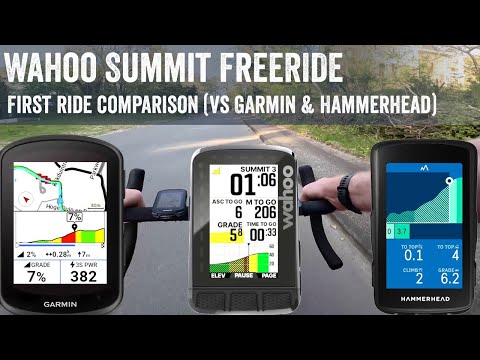
Now, no better way to show this than a simple and quick video with an actual climb showing the screen recording on not just the Wahoo ROAM V2, but also the Garmin Edge 840 and Hammerhead Karoo 2 – all side by side.
As you approach the climb you should get a warning about 150m out. In my case, that didn’t trigger, perhaps because I wasn’t on the lead-up road long enough, or whatever may be the case. Once you cross the threshold though, you’ll get a note to ‘CLIMB!’.

At that point, you’ll see a full slate of climb details on the Summit Segment page, as seen below. Notably, you’ll also get Strava Live Segment information shown along the bottom too:

For the most part, the above is pretty darn similar to their competitors – I talk through that in real-time in the video. Wahoo triggered in the same rough ballpark as Garmin & Hammerhead for this particular climb. And all three ended at slightly different points from the kinda flat-top ending area. Meaning, it wasn’t a really crispy ending point, thus they all chose different spots to call the climb ‘done’. This is what we’ve long seen with these technologies, even in course mode. The definition of when a climb starts differs even in real-life between actual people, so it’s somewhat natural for companies to have different thresholds as well.
Now there are some added nice touches. Wahoo will also show both upcoming and current climbs on the map using chevrons. A reddish color for upcoming ones, and green for current ones (plus orange for Strava Live Segments), indicating exactly where the climb starts/ends:

Additionally, Wahoo will continue to show an up-ahead look at the road elevation profile, even once the climb is completed. So this not only shows it approaching the climb, but also down the road (or up the road) beyond the top of the hill. This is a super nice touch:

Like Hammerhead, they also show a list of completed climbs, even in free-style mode. Garmin doesn’t seem to show this anywhere except post-ride.

On the downside, there isn’t any way to see average gradient remaining – just the average gradient for the entire climb (start to finish, regardless of where you are). Additionally, I tried two other climbs that theoretically would have met Wahoo’s lower threshold, and neither triggered. One did actually trigger Garmin’s threshold (but not Hammerhead’s).
Again, this is an area where I just need more time/climbs to see if there’s a pattern to be had there beyond a single quick ride.
Wrap-Up:

As I’ve said many times before, Wahoo is rarely first to do something these days. Anything really. However, when they do finally do it, they usually do it slightly better than others. One could say they give features ‘more thought’ than some of their competitors, even if that thought somehow takes years of thinking. But that nuance is often super well executed. We saw it with Strava Live Segments (better than Garmin’s implementation), and with bike GPS to watch integration on the Wahoo RIVAL (better than Garmin’s Extended Display).
And that’s mostly true here with Summit Freeride, with a number of elements that are better than anyone else. The fact that I can take these climb page data fields and stick them on any page? Very cool. The fact that it scales down to climbs as short as 250m if they’re a bunch steeper? Very cool. And the fact that the upcoming elevation profile page stays on ‘beyond’ the top of the hill in free-ride mode? Again, very cool.
That said, it’s also not perfect. For example, Garmin’s free-ride ClimbPro detected one climb that Wahoo didn’t – despite Wahoo’s lower thresholds. Additionally, Wahoo is somehow missing a ‘gradient remaining’ data field – arguably one of the most useful fields there is (the current field only shows average gradient of the entire climb).
Now, three Summit areas I just don’t have enough data/time on yet are:
– How does the climb start triggering points look over a wide variety of climbs/locations?
– How does the underlying road/map gradient data look (accuracy-wise) over a wide variety of climbs?
– How does it handle road/route splitting mid-climb? Is it based on popularity data, or…?
These are two specific areas that Garmin (trigger points) and Hammerhead (underlying map gradient data) have issues with on their free ride implementations. And I simply need more riding to these out – same goes with route/road splitting.
The good news there though is that as you read this, I’m literally boarding a plane to a locale with plenty more climbing (like the second this post goes live the plane starts boarding). So I’ll be putting this to the test over the coming days, alongside gradient reaction time as I’ve been doing recently for the Edge 540/840 units in those reviews. All of which should result in a nicely refreshed ‘Best Climbing GPS’ post/video shortly.
With that – thanks for reading!
Found This Post Useful? Support The Site!
Hopefully you found this review/post useful. At the end of the day, I’m an athlete just like you looking for the most detail possible on a new purchase – so my review is written from the standpoint of how I used the device. The reviews generally take a lot of hours to put together, so it’s a fair bit of work (and labor of love). As you probably noticed by looking below, I also take time to answer all the questions posted in the comments – and there’s quite a bit of detail in there as well.
If you're shopping for the Wahoo ELEMNT ROAM V2 or Wahoo ELEMNT BOLT V2 or any other accessory items, please consider using the affiliate links below! As an Amazon Associate I earn from qualifying purchases. It doesn’t cost you anything extra, but your purchases help support this website a lot.
And finally, here’s a handy list of accessories that work well with this unit (and some that I showed in the review). Given the unit pairs with ANT+ & Bluetooth Smart sensors, you can use just about anything though.
The Garmin Varia radar alerts you to cars coming up behind you, well before you see them. It's awesome for quieter roads (country roads/mountains), especially on longer rides. It's less useful for city riding. The RVR315 skips the light.
The Varia radar has become incredibly popular in the last year, with most bike GPS companies supporting it (Wahoo, Stages, Hammerhead, Garmin, and more soon). It notifies you of overtaking traffic. While useless for cities, it's amazing for quieter country roads.
Wahoo RPM Sensor
This dual ANT+/Bluetooth Smart sensor will transmit cadence not only to your bike computer/watch, but also 3rd party apps like Zwift, TrainerRoad, and more.
Wahoo SPEED Sensor
Speed sensors are primarily useful for offroad usage. I don't find much of a need for one while road-cycling, but for mountain bike trails they can help alleviate speed/distance issues with poor GPS reception in dense trees.
This is a solid Speedplay-based power meter, which I use from time to time in my accuracy testing of various smart trainers, power meters, and more.
Wahoo TRACKR

The Wahoo TRACKR is Wahoo's newest strap which aims to fix all the issues with older straps. I use it from time to time, and it's perfectly functional.
And of course – you can always sign-up to be a DCR Supporter! That gets you an ad-free DCR, access to the DCR Shed Talkin' video series packed with behind the scenes tidbits...and it also makes you awesome. And being awesome is what it’s all about!
Thanks for reading! And as always, feel free to post comments or questions in the comments section below, I’ll be happy to try and answer them as quickly as possible. And lastly, if you felt this review was useful – I always appreciate feedback in the comments below. Thanks!


With that information it’s even harder for me to decide which road to go. Have the Garmin 840 in hands and I like ClimPro and I‘m an even bigger fan of real time stamina. But what really annoys me is the readability of the datafields as well as the map. I like the Wahoo style way more! Now I have to decide if Real time stamina is a game changer for me or not. I guess this feature won’t make it to the Wahoo at any time.
So free ride climb pro is going to be possible on present hardware from wahoo
unlike my garmin 530 ??
Sorta.
It’s only available on the two newest devices from Wahoo – the BOLT V2 and ROAM V2.
Garmin did backport it to the Edge 1040 (June 2022), which came out before the ROAM v2 (Oct 2022). However, the BOLT v2 is older, from May 2021. Wahoo didn’t include the original ROAM, despite having coloring (other older units didn’t have colors).
Ray, thanks for the post!
Do you know if Garmin backported free-ride ClimbPro or will do so for the Explore 2? Now I understand that’s the only thing I REALLY need from the GPS unit.
Do we have enough data points to speculate when a Bolt V3 could exist?
As a Bolt V1 owner, I am missing out on some significant features that are available on the V2. I just wonder how much longer I might need to hold out waiting for a V3 release.
Hello Ray,
Is the non availability on Roam v1 due to limited memory of 2GB?
Do you observed bigger map files as for new Garmin edge x40 serie vs x30 serie?
Roam v1 also has very limited color display and slower CPU.
>> Do you observed bigger map files as for new Garmin edge x40 serie vs x30 serie
In his 840 review Ray did exactly that. Quote:
>>Now, it’s important to note that with the Edge 540/840/1040 getting the new ClimbPro free-ride functionality, the map sizes have exploded. I mean, almost doubled in size
Very good question and I’m in same position. My V1 Bolt been great but must be 6 years old now and I’d love to have the climbing features etc but don’t want to splash out on a V2 if a V3 around the corner.
“Do you know if Garmin backported free-ride ClimbPro or will do so for the Explore 2”
Good question – I don’t know. I’ll ask.
Based on their recent credit rating change and rumblings from inside the company we can’t even confidently say that Wahoo will exist in a year.
Based on their recent credit rating change and rumblings from inside the company we can’t even confidently say that Wahoo will exist in a year.
Just like to say that my Roam V1 updated before my ride this morning and I was very pleasantly surprised to see a new gradient data screen pop up on a “free ride”. Gradient Profile also appeared on the map page too, again not on a preloaded course. Although I didn’t spend much time analysing the map page as it was a familiar route it was very interesting to see the gradient on my normal screen. Struggled a bit to pick up the incline on very short steep inclines but overall I’m impressed.
Having said that having read about this a bit more I wonder if I’ve just stumbled on an old feature that I didn’t realise when I’ve been changing my data fields to accommodate axs😖
A quick note for anyone considering using/buying the Edge 1040 for free-ride ClimbPro: the feature has not yet been implemented in the software in most of the world. Some regional devices have it, so eventually it will hopefully get there. While Garmin sent an email to users mid May announcing the new feature, it actually hasn’t been implemented globally. The maps can do it, but the device cannot. My wife’s 840 does well, while my 1040 doesn’t. Garmin accurately describes it on their website as “Automatically see the remaining ascent and grade when you’re climbing while following a route or course.” However – as usual – they messed up their announcements.
Setting aside APAC devices (a very specific device for Asian character sets), if you’re Edge 1040 isn’t seeing it, it’s likely that you don’t have the maps fully updated to the (much bigger) maps.
Else, it should be on there just fine. I haven’t seen any comments that it’s not working in certain areas, rather, when it’s not working for someone, their maps didn’t update.
Thanks for the quick reply. When I asked Garmin they also said it’s Asia where they have not yet made it available. They manage to make updates globally for Epix devices, but not Edge. However they consistently announce that software is available when it is not, except in some smaller parts of the world. (Asia is 60% of the world population, but probably not customer base.) Hence the warning for anyone considering it to be very careful with Garmin.
My personal albeit limited experience with Summit Segments was complete garbage. Tried using the feature on Mallorca during a trip some two weeks ago, and it felt like it never properly identified neither start nor end of climbs properly. Most often it thought the climb ended too early even though the displayed height profile clearly showed there was some ways to go yet.
Maybe the map data for Mallorca isn’t detailed enough? In particular the coloring of the height profile that should represent the gradient seemed to always be way off. Is the height profile and thus Summit Segments based on the onboard maps or built into the routes? Our routes were mostly done through Komoot, some through Strava.
Weird, I had no issues with the regular Wahoo summits (course-based) two weeks ago in Mallorca – including most of the major climbs there.
Now, the Komoot piece is actually interesting. GPLAMA and I were looking at this recently, and Komoot really dorks with elevation profiles – basically flattening a lot of climbs. I had one route I did via Komoot and one via Strava – all then funneled to GC and onto the Edge, and they were surprisingly different.
It’s on my ‘things to dig into’ list.
I’ve often wondered why Garmin simply doesn’t use its own onboard DEM rather than relying on the elevation in the course file. I’ve seen similar weirdness in routes I created with Strava. Since watching GPLAMA’s recent video on broken ClimbPro, I’ve populated my new 1040 directly from GPX files downloaded from Strava rather than through Garmin Connect. Yesterday I navigated a ride and on a long downhill there was a non-existent cliff on the elevation profile. Since it was downhill it didn’t affect ClimbPro at all, but on my 830 similar imaginary cliffs on other rides produced imaginary climbs (with some nasty grades!)
I wish they also changed to colored chevrons while navigating. These chevrons seems way more legible than the solid black ones. At least give them an outline. The bike path color (dark blue) with the chevrons (black) is not really contrasting I find. Did they also do that with this update or is it purely the Summit Freeride function?
Real bummed about the lack of support for the OG roam, have been considering switching away from Wahoo due to lack of climbing feature when free ride.
Had my first preloaded route this weekend after they added the summit feature (was not aware this was a thing). With this change I lost my normal page that had the full route profile on it and I could not figure out how to get it back mid ride. Quite disappointed.
I really like what Garmin offers however I am scared of their UI / app integration that is one thing wahoo does fantastically.
Do the newer garmin units have issues uploading to strava? I know post ride my friend is waiting a good bit for his rides to get sent from his garmin to strava (is the phone an intermediary in the process?) I Know wahoo does that great as well.
“Do the newer garmin units have issues uploading to strava?”
On my 1030 I generally stop my ride at the side of my house and by the time I have got to the back door I’m getting a notification on my phone saying the ride is ready to view. The Garmin does it via my home WiFi, never had a problem.
Away from home just sync my phone to the Garmin via the connect app and it does it.
2 things struck me while watching the video
1) Is there any way to compare coverage of climbs in my area from the 3 companies?
2) Rainmaker has watch tan lines on both arms.
1) I’m not sure how to do that. Garmin has Climb Explorer, to see climbs, but it’s only on a per device basis – so not some sort of database to poke around.
And neither Hammerhead or Wahoo has anything like that, that I know of.
As for the watch lines…had to take off the watches before filming.
…had to take off the watches before filming.
Looking for some interesting new reviews in near future 😉
I switched to Garmin because of the lack of ClimbPro, and I have to say that I find Garmin overall UX way worse than Wahoo’s. I’m pretty sure I’m going to switch back !
I fore see a glut of 2 year old garmins on eBay
Ray, regarding the picture showing upcoming and current climbs… that’s press stuff from Wahoo?
I mean, look at the map… that’s the same road in two different directions? That cannot be a climb in both directions… something is really odd there!
Yup indeed, and also yeah, I noticed that as well. But, decided against making fun of them for it – I had reached my quota of teasing in the post already. I’ll have some of my own actual shots of that later this afternoon.
It’s definitely press stuff. They just slapped the compass on there as well.
^Sorry, you can delete these.
I am an original Wahoo Bolt owner and getting itchy to upgrade. Any word on whether a Bolt V3 will come out in 2023? What about a Karoo 3? Current Karoo and Bolt are probably more than capable, but I am a sucker for buying the current model of something only to have the next iteration come out within a few months.
Any idea if it will trickle down to the roam v1?
“Now there are some added nice touches. Wahoo will also show both upcoming and current climbs on the map using chevrons. A reddish color for upcoming ones, and green for current ones (plus orange for Strava Live Segments), indicating exactly where the climb starts/ends:”
I used this for the first time today, no sign of any Strava Segment overlay as mentioned. The climb feature worked really well, both with a route and without. Can anybody confirm the orange overlay on the map page for a Strava segment works? I use both private and public segments, starred and synced, to brief clients and set pace/targets when riding.
Thanks.
.
.
Am I the only one who finds these features to be super, super annoying? Wahoo enabled them via a software update and I was able to mostly disable, but not entirely. I live in a very hilly area and now every time I turn onto a slightly steep road, like even in my neighborhood, it says “CLIMB!” And then when I turn it says “SUMMIT!”.
This is so inexplicably annoying. I feel like the dude on Office Space who wants to murder the copy machine. Particularly when I’m just trying to bust out some intervals on hill repeats and every time I turn around mid climb it detects a summit.
Serenity now.
Is there any way to see the ‘completed climbs’ page/data post ride, either on the Wahoo or, better, the app? I can’t see a way and it seems like a lost opportunity – for sure I’m not going to reading the page whilst riding.
Freeride summit should work with or without a route loaded. But for me, it seems to only work when a route is NOT loaded. When I chose take me to feature, the climb information page does not pop up. Any help?
I’ve haven’t measured it in any way, but this new feature seems to be pretty significantly power consuming. I was very glad with my bolt v2 battery life and I’m pretty convinced it’s worse after updating firmware including this feature.
I have an issue with the summit function: Although ruling out small climbs they are included in my summits (a little annoying when it’s hilly and I get summits popping up all the time). Friends have the same problem. Support at wahoo couldn’t help. Anybody with the same issue? Any solution?
And btw: Why does navigation information pop up on map page where it blocks two data fields? In my opinion not necessary.