Some six years ago I did a post on how to add free maps to your Garmin Edge series device. Back then, Garmin didn’t include any meaningfully detailed maps for any Edge devices, you had to buy those separately – often costing $50-$100 per map/region. These days, things have changed a bit. Garmin now includes maps for the region you bought it in (such as North America if bought in the US, or Europe if bought within Europe), but they still don’t include any way to freely download maps for other regions (such as going for a trip from the US to Europe).
Somewhat astoundingly for a tech-specific post, everything I wrote in that post all those years back is still actually correct in terms of steps. However, for the sake of cleaning things up (and search optimization), I’m going to refresh both of those posts. Starting today with the wearables side. Back then Garmin didn’t have any wearables that could do maps. But these days they do support it on a few units – so we’ll start with that today, and then on Friday I’ll give you the refreshed version for the Garmin Edge Series. Though, spoiler: It’s the exact same steps as below.
Note that while Garmin would prefer you buy the maps from them, they actually go out of their way to allow you to download free maps from 3rd party providers. They simply note that it’s unsupported (but doesn’t void any warranties or such). Meaning that if the 3rd party map data isn’t perfect, it’s not their fault. But here’s the dirty secret: It’s the same underlying map data.
For virtually all of Garmin’s maps included on Edge/Forerunner/Fenix/MARQ series devices, the base map itself is OSM (OpenStreetMap). What differs is some of the special sauce Garmin adds atop it (heatmap type data), as well as the exact layers Garmin does or doesn’t display (how it looks, but also things like topographic lines).
I myself often use the freely downloaded variant I describe below (because I live in Europe, but often buy my units in the US). Or, for the European units I have when I travel to the US/Canada, like two weeks ago. And thousands of you every month do the same following these previously published steps. With that, let’s get into all the supported units and requirements and a few minor caveats below.
Requirements/Caveats:
While this post probably looks long, it’s mostly my attempt at answering any questions ahead of time. In reality the entire process is super quick and easy. I’m just overly thorough in my screenshotting excitement. The actual active time for you to do this is like 3-5 minutes tops.
You must have a computer – Mac or PC (or even Linux). You cannot do this from an iPad or such. It’s technically possible to do it from an Android device with the right cables, but you’re on your own for that!
As for compatible devices, here’s the list of devices this will work on. It also will work on most of the handheld type outdoor devices too. If it supports Garmin maps, it’ll support 3rd party maps.
Compatible Wearables: Garmin Forerunner 945, Garmin Fenix 5s Plus, Garmin Fenix 5 Plus, Garmin Fenix 5X Plus, Garmin Fenix 5X (non-Plus), Garmin Fenix 6S Pro, Fenix 6 Pro, Fenix 6X Pro, Fenix 6X Pro Solar, Garmin Epix (RIP), Garmin Descent MK1, Garmin MARQ Series, Garmin D2 Delta PX
Compatible Bike Computers: Garmin Edge 520/520 Plus/530, Garmin Edge 705, Garmin Edge 800/810/820/830, Garmin Edge 1000/1030/Explore/Touring variants
Now you may be asking yourself, ‘What if I have a non-Garmin unit? Will it still work?’ – and the short answer is basically no. There may be some 3rd party units that work with these maps, but nothing major. Plus, many other competitors like Wahoo, Stages, and Sigma simply make it easy for you to download maps without all this fuss. For this post, it’s all about the wearables, so I won’t focus on some of the nuances of having a microSD card for some of Garmin’s older/larger bike computers. That’ll be a separate post.
Finally, since I know some of you will ask, the following are most definitely *not* compatible. And the reasons are simple: They don’t have the storage, or they don’t have the processing power to handle maps. The ship has sailed on all of these (read: they’re definitely not getting map support),
Non-Supported Wearables: Garmin Forerunner 15/20/30/35/45, Garmin Forerunner 225/230/235/245, , Garmin Forerunner 610/620/630/645, Garmin Forerunner 735XT/910XT/920/935, Garmin Fenix 5S/5 (non-Plus, non-X), Fenix 6S (non-Pro), Fenix 6 (non-Pro) Garmin Fenix 3/3HR, Garmin Fenix (original), Garmin Vivo-anything, and countless others. Consider this just a ‘starter list’ of non-supported units.
Non-Supported Bike Computers: Garmin Edge 20/25/130/200/500/510, and probably a few really old others.
Note that for unsupported watches there is a hail-mary option, which is DWMap. This works on a slew of newish watches that don’t support maps (like the FR645, FR735XT, and FR935, among a number of others). It’s not a perfect mapping replacement per se, but it’s definitely a solid option when there’s nothing natively. It’s also won Garmin’s Connect IQ app of the year award as well, so nothing sketchy about it at all! Full details here.
Last but not least – note that Garmin does add ‘special sauce’ to their maps – most notably what they call ‘Trendline Popularity Routing’, which is basically a variant of heatmaps. The main use for this is when you ask the device itself to create a route on the fly (such as roundtrip routing) that it leverages heatmap data to give you routes that people use more often. However, this is only applicable if you create/re-route on the device itself. You can still take advantage of that concept by simply creating the routes on Garmin Connect or Garmin Connect Mobile first, which will use that same data from the cloud.
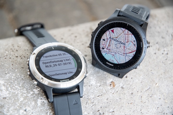
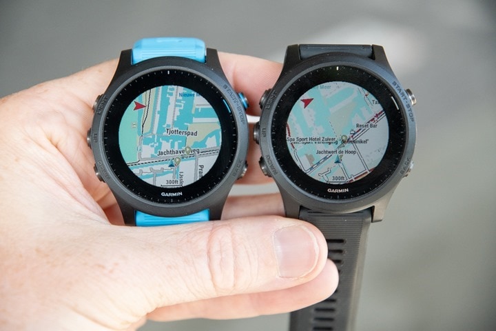
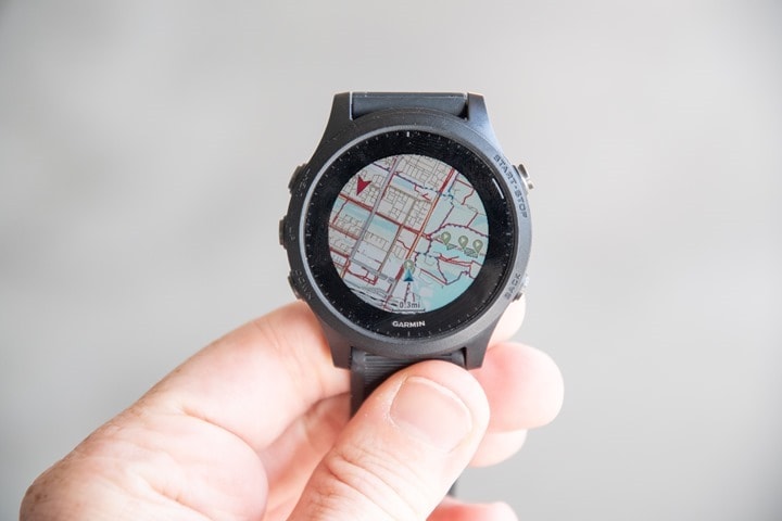
In addition, there are some slight nuances to how the maps look in terms of exact styling. You’d never know unless you had the two side by side, which you’ll see below. At left is what the default Garmin maps look like, whereas at right is what the free OSM maps look like:
I find the shading/clarity of the Garmin maps to generally be better/optimized. But both are perfectly functional. However, you also won’t get topographic contour lines when using the free maps. Technically speaking you can download them and merge them together, but that’s beyond what I’m going to cover here.
Part 1: Downloading the Maps:
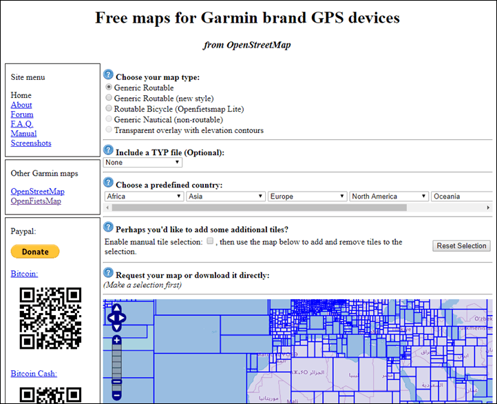
This entire post is ‘made possible by’ OpenStreetMap, which are free community-driven maps. OpenStreetMap has become in many areas just as good as maps from traditional providers. And best of all, they’re free. The below site simply does all the hard work that you used to have to do manually a few years ago if you wanted to use OpenStreetMap. Now, it’s literally as easy as 1.2.3. Seriously, you can do these clicks below in under 15 seconds.
First up, going to the site. Which, will bring you here:
Note that every once in a while that website goes down – as if someone didn’t put enough coins in the slot. It’s a community-supported page after all. I’d strongly encourage you to donate occasionally (even just $5, it saved you like $100 anyway). I do. If the site is down, you can use another site here. The downloading steps are slightly different (select Garmin BBBike as the format, Map type OSM Mapnik), but ultimately all basically the same. I have no relationship to either site, it’s just what I’ve used for a long-long-long time now.
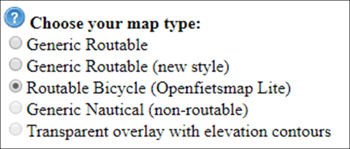
Once the page loads, you’ll want to select ‘Routable Bicycle’ as the map type.
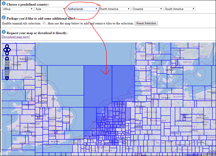
Next, you’ll select the region/area of maps you want. If you simply select a pre-defined area (like a given country/state/province), then the site has already premade these for you, so they are instantly available. Kinda like picking up sushi from the case at the grocery store (except less sketchy). Whereas if you want something custom – perhaps across multiple countries/borders, then you can choose to create a custom map set.
If going for the preset sushi, you’ll start by choosing your continent, then country. In some areas (such as the US and Canada), you’ll also choose the state/province. You’ll see that it automatically selects the coverage area in the map below.
If you don’t need anything custom, then just click ‘Download Map Now’:
That’ll bring you to this page. Select the one that the little MicroSD card icon next to it. DO NOT select the Windows, Mac, or Linux ones. It doesn’t matter what computer you’re using to download things, always-always-always select the one with the MicroSD card icon (also titled ‘GMAPSUPP.ZIP’ appended to the end of it).
Download and save that somewhere handy on your computer (like your desktop) and skip ahead to the installation section!
[Again: Skip ahead to the ‘Installation’ bulleted section if you’ve just downloaded your map!!!]
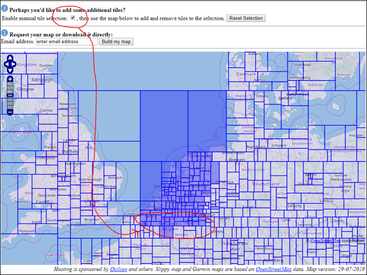
Whereas if you want to roll your own custom map with added areas, then you’ll select the checkbox titled ‘Manual Tile Selection’, and go from there. As a pro tip, if you’re just adding a bit more territory to an existing predefined set, then start by selecting that first, then checking the manual option. As you can see below, I started with the Netherlands, and then I checked the box and added a few more map tiles from Belgium/Germany/France onto the Southern portion of my Netherlands map:
Once you’ve selected everything you need to select, then put your e-mail address in the little box and select ‘Build my map’:
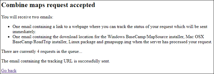
The reason you need to provide an e-mail address is because you go into a queue for the server to create your map. Like waiting for your name to be called at the DMV, except, more efficient. Here’s what it’ll show a second later:
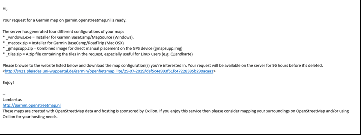
And sure enough, just as it says I’ll instantly get an e-mail with my status:
And a few minutes later I get another e-mail with the download link saying it’s ready. Usually that’s all it takes. I don’t think I’ve ever had to wait more than 10-15 minutes.
Just like with the non-custom ones, select the one that the little MicroSD card icon next to it. DO NOT select the Windows, Mac, or Linux ones. It doesn’t matter what computer you’re using to download things, always-always-always select the one with the MicroSD card icon (also titled ‘GMAPSUPP.ZIP’ appended to the end of it).
And again, remember that there’s a ‘Donate’ button on that site (I have no affiliation with it). Obviously, good karma dictates that if you find their (free/community-hosted) service valuable, sending a couple of bucks their way is probably wise – especially given how much money you’re saving. Plus, it’ll probably make that map creation bit go faster for custom maps if they get more support.
Part II: Installing the Maps:
Installation of the maps is super easy. All you need to do is put the file in the correct folder and you’re good to go. All of the wearables we’re discussing here have plenty of space, so it’s unlikely that you’ll need to remove any existing maps unless you’re downloading a huge map or have a ton of music. If you do need to do that for some reason, then refer back to my older post with the Edge 520 instructions (even if you’re talking a wearable). That’s because that was a highly space-limited device and thus the steps would be the same.
To put it into context, the Garmin default map data sizes are roughly as follows (the maps you’d get by default for the region you purchased it in):
North America: ~5.6GB including topo data
Europe: ~6.3GB including topo data
Australia/NZ: ~2GB including topo data
And size-wise, you’ve got roughly 16GB of space on the Forerunner 945 and Fenix 5 Plus series watch, and 32GB on the MARQ units and Fenix 6 Pro Series. So you’ll want to do simple math to see if everything fits. For context, the download size for the Netherlands from the free maps is 0.37GB (337MB) – so pretty small. France is ~1GB. Again, should easily fit. But if you’re tight on space, you can always follow the custom instructions above and take a prepackaged map like France and make it smaller by removing areas you don’t need (if you’re staying in the Alps, you don’t need the entire Western portion of France for example).
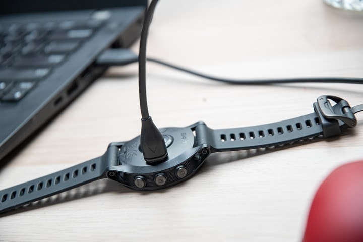
In any event, let’s install things. First, connect your Garmin Forerunner/Fenix/whatever to your computer using the USB cable it came with.
Go grab that file you downloaded (openfietsmap_lite_gmapsupp.zip), and open it up (just double-click it). This is what you’ll see inside:
You need to copy that single file somewhere on your computer. Technically speaking, your ultimate goal is the Garmin folder on your wearable, but because of the way recent Garmin music-enabled devices show up in Windows, you won’t be able to copy it straight from the ZIP file there. Short version: Just copy that file to the desktop first.
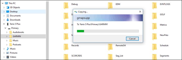
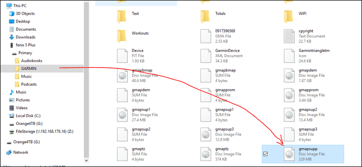
Then select that file and then select ‘Copy’. Now simply paste that into the ‘Garmin’ folder on your watch. Do NOT copy/paste the entire .ZIP file, you need the file inside the zip file (like you see above). It’s called gmapsupp.img and needs to go into the Garmin folder on your device.
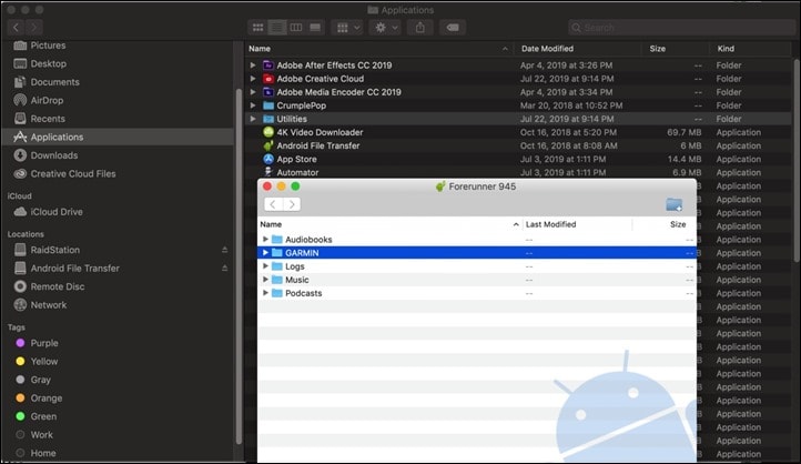
If you’re on a Mac, it’s a little bit messier these days. That’s because the Garmin wearables are in MTP mode, which is great for music, but sucky for installing maps. You’ll need to install a little (and crazy-widely used) utility called ‘Android File Transfer’, as well as then close/quit Garmin Express if you have it installed/running on your Mac (it’ll block access otherwise). Normally this utility is used to allow Mac’s to connect to Android phones. But works here well.
Once you’ve got it installed, open it up (again, remember to fully close Garmin Express first), and then plug in your Garmin device. It’ll show up just like below. Simply drag the gmapsupp.img file into the Garmin folder. Remember not to drag the .zip file, but rather the .img file inside the zip file.
Once it’s done copying, you should now see that file sitting in the Garmin folder. The names will be similar, but it’s the one ending in ‘Supp’ (like ‘supplementary’):
And with that, you’re done.
Side note: Need to have two extra downloaded maps? Simply append the country name to one of them to make it unique. Such as ‘gmapsupp-germany.img’ and ‘gmapsupp-france.img’.
It works perfectly fine.
Part III: Using the maps:
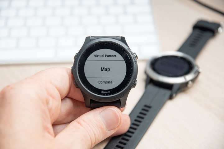
Actually, there’s nothing you have to do here. Once you’ve installed them they just work. If you haven’t added the map data page to your wearable, go into the sport profile of your choice (Hold the middle button > Activities & Apps > Choose your sport > Settings > Data Screens > Add New > Map:
However, in the event you want to turn off the downloaded mapset for some reason, it’s pretty easy to do (and you can always delete that single Supp.IMG file if you need the space after your trip.
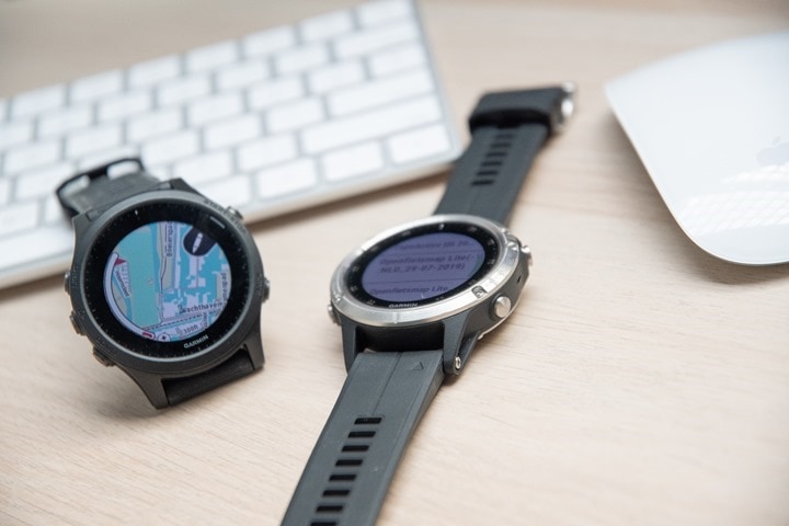
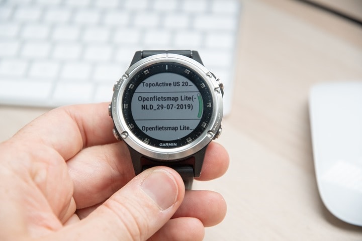
To disable a given map though, on your device hold the middle button > Activities & Apps > Choose your sport > Settings > Map > Configure Maps > Toggle on/off the map that you just loaded. You can see below the Openfetsmap Lite-NLD, which is my Netherlands map. While above it is the Garmin TopoActive US Map since this was a US Fenix 5 Plus. By pressing the select button, it’ll turn on/off the different maps. Super easy.
And that’s it! You’ll be able to use these maps as normal. That includes things like elevation details for courses, planning between points, points of interest, and round trip routing. And on Edge series devices, even routing to specific addresses. But more on that later in my Edge-specific post.
As always, thanks for reading. And if you found this post helpful – consider becoming a DCR Supporter, I appreciate it!
(And stay tuned for the Edge-specific variant of this post on Friday)
FOUND THIS POST USEFUL? SUPPORT THE SITE!
Hopefully, you found this post useful. The website is really a labor of love, so please consider becoming a DC RAINMAKER Supporter. This gets you an ad-free experience, and access to our (mostly) bi-monthly behind-the-scenes video series of “Shed Talkin’”.
Support DCRainMaker - Shop on Amazon
Otherwise, perhaps consider using the below link if shopping on Amazon. As an Amazon Associate, I earn from qualifying purchases. It doesn’t cost you anything extra, but your purchases help support this website a lot. It could simply be buying toilet paper, or this pizza oven we use and love.











For my GPSmap64s I prefer the link to freizeitkarte-osm.de maps (should also work on the fitness devices mentoined above.
No worries they are not only in German.
But are they up to date?
Where can I check the date of the last release of the map?
:)
And http://frikart.no is another one, more topo map like renders from the same openstreetmap source.
Nice – good to have options for topos! Might be a fun follow-up post!
link to garmin.opentopomap.org
Yes Ray, when I saw the new article I thought you upgraded your map sources. Definitely explore MTBMaps, VeloMaps, freizeit karte, and my best frikart.no. You download a country, which is better than tiling. You have a table listing most if not all Garmin OSM maps on the OSM Wiki. Just google Garmin OSM maps Wiki.
Yeah, there’s lots of options here people are finding. I think the common thread I’m hearing though is that many of them are specific to a certain type of activity, or better in a given region (but not as well outside those regions/activities).
I think for across the board maps (no matter where you’re going or most of the activities), Garmin.OpenStreetMap.nl seems to be the best ‘just works’ answer. Remember: The tiling only matters if you want to customize it, otherwise you just download a country as-is, nothing complex there.
Whereas I’ll try and consolidate other specific use cases or areas that might be better on other platforms into a list for Friday’s Edge post (and then add them here too).
I looked twice (maybe should’ve look three times?) but couldn’t find anything about the Garmin 645 (sans music). Supported or not?
Thanks!
Nope, I’ve got dwmap on my 645 and 630. Not as good as osm but more than gets the job done if your following a course in a unfamiliar area
Indeed, sadly no mapping support there. But I agree DWMap is a good option for unsupported watches.
I actually had it in the post originally, but couldn’t find a good article on it. Just found one though to link to. Sweet!
(This: link to medium.com)
http://gmaptool.eu maintains really good TOPO maps of Africa and North America. I am an American living abroad in Africa so my Garmin came loaded with US Maps and not Africa. I have also purchased the Garmin versions and the GMapTool ones are as good or better and are updated more frequently. I have recently been in the desert South West US and found the GMapTool TOPO Maps had better trail coverage than the built-in Garmin maps — which is also my experience in Africa.
The OpenFietsMap light maps you are using are derived from the OpenFietsMap project link to openfietsmap.nl. They have much higher resolution maps available for Netherlands, Belgium, Luxembourg (which they call Benelux) and to a lesser extent Germany.
There is http://opentopomap.org which focuses on OSM with TOPO lines for European countries.
Garmin has MapManager and MapInstall software which is useful for importing maps into BaseCamp and sending maps from BaseCamp to the watch. This all works great on macOS with my 5X but seems flaky with the 5 plus series. MapInstall kept failing with a useless error message with the 5 plus. It sometimes worked with a 5 plus I was setting up for a friend but mostly failed with a useless error. We ended up copying the img files between watches.
Great tips for Topo, I’ll try and get these consolidated and added in, for folks that want to take the extra steps.
Thanks!
I would like to add that if yo want to use these (OpenStreet) maps for something like a holiday, you should download them a few weeks prior. The OpenStreetMaps site is sometimes down, or very delayed (like 5000 waiting before you), for a week at a time. Can’t complain, it is free, and when it works it is very good, but it can be a bit frustrating when you try to download on Sunday, when you fly to Mallorca on Monday for a cycling holiday… (yes, experience talking…).
Yeah, as noted sometimes it does go down – I suspect due to funding. I linked to an alternative that people have used in the past when it goes down.
But ultimately, totally agree with you (and also been bit before as well when travelling and forgot). Thankfully now with secondary options, there’s at least a clear backup.
To be clear, garmin.openstreetmap.nl is not “a” or “the” OpenStreetMap site it is a privately operated undertaking that uses OSM data to produce Garmin format maps.
Unluckily it doesn’t make that very clear which causes constant confusion and complaints to the people that -do- operate official OSM infrastructure that have nothing to do with the operation of garmin.openstreetmap.nl and really have better things to do than answer complaints about an unrelated site.
Not to point out the obvious here: But perhaps those folks (you) could actually offer a service that numerous other people have had to implement so people (consumers) can actually use those maps offline direct from the source, rather than through 3rd parties.
The comments section here is full of 3rd party links/places where people have created solutions for ways to download the OSM data (and this is only a fraction of them). Which seems like a pretty clear indication that a gap exists to actually get that data to end users.
Said differently: Instead of complaining about the complaints, actually address what people are complaining about.
As a general rule the OSMF does not offer end-user services, nor has funding to do so (the annual OSMF budget is ~£100’000), The model with third parties turning OSM-data in to end products works well as it would in this case if the operators of the site would make the situation clearer.
Ray, you don’t see the whole picture. It’s not a gap, it’s a feature. Openstreetmap is all about data, it has much more data that you can see on any single rendition of the map.
Hence there’s a freedom to tune rendering style for your own use and liking. Visual representations of OSM data for hiking or cycling, off-road or urban use would be completely different, and OSM foundation deliberately stops there – they give world data and tools, not single product. That’s why all those sites exist and cater for different needs of end-users.
As a side note – that’s also why Garmin in particular has a religious following from certain crowds despite of all the bugs. Ability to endlessly customise and layer maps mixing official, OSM, and specialised stuff like Trailforks layer is not offered anywhere else apart from Android phones. For MTB, off-road touring and general exploring, especially in countries or territories less covered by official mapping there’s simply no alternative to homebrew mapping. Only Garmin’s map format is well known and didn’t change much since early 2000s with solid community tooling freely available.
I see the picture, my point was far more subtle perhaps: Don’t complain about things without offering solutions.
I think it’s great that OSM offers the data and tools. It allows for small sites to access it, as well as even big corporations (including Garmin), and medium size companies like Wahoo or Sigma – all leveraging it.
My point was simply that Simon comes on here complaining about another site offering a solution that is perhaps confusing to end users (and that he has to handle confusing e-mails). Thus, my response is more direct: Fix the issue.
If the issue is confusing branding from 3rd party sites – then fix the issue within the license agreement. Best I can tell from reading it – there’s nothing meaningful there around that – hence why every site linked here in the comments comes off looking like the real-meal deal. So when there’s nothing meaningful around that, then OSM only has themselves to blame.
If the issue is confusing because users want the OSM data in other formats but can’t figure out how to get it on their devices, so end up on 3rd party sites that make it easy – then again, OSM can’t complain about that implementation if they don’t offer anything at all to fix it. That’s a gap. There’s nothing that says that 3rd party sites can’t do it too. I’m just saying for core data, there’s no reason why OSM can’t do it themselves (and yes, I saw the whole 100K argument, honestly, that’s lame. If OSM can’t find ways to get more revenue than 100K a year given how many companies and individuals leverage their platform for profit, then that’s on them.)
Don’t misunderstand what I’m saying. I’m basically saying my general rule in life is that you lose the right to beat the drum and complain when you don’t offer a viable/alternative solution. Otherwise it’s just whining. :)
I’m sure others disagree, but that’s just my take.
Ok, fair enough. Actually, OSMF is not the healthiest organisation right now as far as I know (link to blog.emacsen.net), and that exact argument of 100K non-profit vs endless business opportunities is highly divisive within the community, so I’d rather not go there and just appreciate what we have.
And yes, it is whining, but that kind of whining is sort of cultural thing within opensource communities. Have you ever tried to maintain even a tiny project on github? :) People will file issues with anything electrical in their house, branding or no branding. You tell them off, you whine how people are stupid, you carry on. It’s not necessarily call to action.
” I would like to add that if yo want to use these (OpenStreet) maps for something like a holiday, you should download them a few weeks prior. The OpenStreetMaps site is sometimes down, or very delayed (like 5000 waiting before you), for a week at a time. Can’t complain, it is free, and when it works it is very good, but it can be a bit frustrating when you try to download on Sunday, when you fly to Mallorca on Monday for a cycling holiday… ”
I had that experience as well, 2 weeks ago on a Sunday afternoon. Needed to leave for the airport and the download link only came in in the last 5 minutes. Thanks for fiber internet at that moment, but my wife wasn’t happy and I had a bit of a headache…)
I had tried this last week using a Mac, but noted that although Garmin Express could sync with my 945, it did not show as a mounted directory. I ended up calling Garmin support and was told that music enabled devices did not show as a directory mount on the Mac. The said if you need to interact at the directory level you must use windows.
See above my note on using a Mac. You’ll need to use a common (free) utility app to let it see the device as a mounted drive. Two-second operation and you’re done.
(The app: link to android.com – remember to close/shut down Garmin Express first, then after installing/opening the Android File Transfer app on your Mac, you’ll plug your Garmin in.)
Ray, thanks for this site and this tutorial. I am heading to do the Sydney marathon and wanted to have the map loaded on my 5X.
I ran into problems on my Mac getting the Android File Transfer to work. Despite all combinations of closing, opening, restarting, updating, etc. it wouldn’t budge off the ‘no android device found’ message. Any tricks to get it to recognize my 5X?
I gave up, opened finder and was able to drag and drop the openfiets img map into my Garmin folder and it seems to have transferred. Hope it works. Do you know of any hacks to get the map to open short of me finding a way to spoof my position to downtown Sydney to see if the map is in fact there and able to be used?
It sounds like you don’t need Android File Transfer, since you were able to use the Finder. If the watch support music, then you need it, and I don’t think the 5X does. If you ever get a Garmin watch that does support music, the trick is to quit Garmin Express completely (when it asks you if you want it to continue running in the background, you say no). When you start Garmin Express again, it will tell you that it needs to kill off Android File Transfer (which apparently also runs something in the background). But that’s all irrelevant for you. If the 5X doesn’t support music, then it shows up on the Desktop in the Finder like any other disk.
When I’ve used my 945 on garmin connect desktop it was trying to download all the world maps on my device (and didn’t have enough memory). Does that mean in GC I can actually just install the maps directly from garmin? I figured I would change it up if I were travelling.
Hmm, I find that typically happens if it stumbles over itself and basically has them downloaded on pending install, but thinks they aren’t install. Let it finish that first.
But, if it’s a legit space issue – then no amount of direct from Garmin will solve it. You’ll have to remove some music or something else to make room.
I had the same happen iwth my 945. Upon initially plugging into garmin connect desktop it just attempted to download all the world maps. I just selected the regions I happen to be traveling to and voila – all the maps I need.
“And size-wise, you’ve got roughly 16GB of space on the Forerunner 945, 8GB on a Fenix 5 Plus series watch, and 32GB on the MARQ units“
I thought the Fenix 5 plus had 16 GB of shared storage?
That’s correct, mid-afternoon coffee and apparently I can’t correctly add free space + used space. Which is funny because I had it correct the first time, and then while double-checking things screwed it up. Fixed :)
I think it has been mentioned before, but when living in the BeNeLux (Belgium, Netherlands Luxemburg) link to openfietsmap.nl is a better option, Also highly detailed maps of the Alps region and other locations. Mapping/routing has been optimised for biking/hiking/running, and I find them highly detailed for trail running!
“…Garmin Fenix (original)…”
Well, actually… Here’s a picture I just took of my Fenix 1 showing a map of my neighborhood. It wasn’t officially supported, and I’ve always guessed it was just an oversight by Garmin, but you could put maps on a Fenix 1. Special, stripped down versions of OSM or they would just be too large for the very limited amount of storage (about 20 Mb), but you could do it and they were useful. Certainly not as useful as a 5+, though.
That’s right, I forgot about that funny little hack.
Garmin made sure that none of the successor Fenixes (Fenii?) could do that until they were actually ready to support real maps on the Epix.
Right. Up untill today I have used maps on my fenix 1.
I just ordered the new fenix 6 pro sapphire, but not because the fenis 1 is not functioning – I just wanted something morde fancy and about 3 times as expensive! And I like the colored maps…But the fenix 1 stays for now, just to make comparisons with the fenix 6…
Is there any difference between the different OSM map downloads, or is it just how the OSM data is rendered?
I’ve been using https://www.velomap.org for years now, it’s not possible to select custom map region, but it got a bundle with all of europe which is quite convenient.. at least convenient enough to prevent me from looking for alternatives..
Herbert i support your question. I don’t know the answer as well. I like to add that i use the same Maps as you plus link to openmtbmap.org for bike and hike ond garmin edge 1030 and oregon 700 without issues and with fun. i name the files this way as an example: mtb-ch-20190731,img (ch is the official abbreviationof switzerland and the the date is the download date).
It will be down to how the map is rendered. Different providers will use different map styles and probably remove/include some different features that the supplier thinks are necessary/not required.
Some are more optimised for a certain activity by tweaking routing rules for a certain mode of transport – velomap is optimised for road cycling for example.
Thank you Meredith to explain this. so is that for hiking an XC with link to openmtbmap.org. You can download the .img files for every country. this people there runs their site for ten years now. i donated there one time and i’m not related to them, but i think they do a great job.
Aside from the map style the contents also differs. You can use a map from Openfietsmap in Basecamp and create a profile that forbids use of tollroads. Basecamp then produces a bit longer bike routes, however with nicer scenery. If you use the Garmin map that is supplied with a Garmin edge device Basecamp gives you the shortest route from A to B.
For Europe I prefer the http://www.openfietsmap.nl maps, they have elevation lines and more detail, at the cost of a larger file size. These are definetly superior to the Garmin maps, a big upgrade. Personally I use the “Alps” maps on a 945.
This one looks great. I’ve used frikart.no upon recently, but I don’t like that it’s just showing random plots when I use the “search nearby” function on the map. It can show something like just a dot (.) and “54m”. No icon or name on the app called POI.
How is this map handling POIs?
If I add an OSM map to my Garmin, what happens to the preinstalled Garmin maps? Looks like, several maps can be active at the same time. Will they be overlayed?
You can have multiple layers enabled, but if they cover the same area then basically it’ll display neither.
So for fun, one one of my FR945’s I have the European Garmin-loaded Topo maps. If I leave that enabled and then put on the free maps, then actually neither will display. Instead, it’ll show me the crappy base-map. In my case about the only thing that shows is a big ring highway around Amsterdam.
But, as soon as I disable one of the two conflicting layers (in the sport settings), then all is well. So this allows you to leave non-conflicting layers – such as Germany and the UK both enabled.
Thanks, I was wondering about that for a while.
Do you know if the number of maps loaded would have some impact on the battery?
Not displaying the map, but only the fact that it is loaded at first.
Hmm, I don’t know off-hand on the specifics of impacts per layer to battery…but…I’ve got a solution for ya (or anyone else)!
The DCR Analyzer! ;) link to dcrainmaker.com
We added battery life display back a few months ago, so anytime you record using a Garmin or Wahoo device (and soon Stages) it’ll show the live recorded battery stats automatically. So you could do some tests, perhaps an hour or so each with differing amounts of layers and then it’ll spit out the average burn rates and show you graphs too (so one could even test navigation with and without the map page showing).
What a great idea… Leave me some time, and I’ll come back with some figures…
Looks like it is a device specific (undetermined?) behaviour.
Whatever map (omtb, OSM, TT50K) I upload to my Fenix 5X Plus or Edge 830, it is always Garmin stock map (Europe) being displayed. I have to disable it to see my custom maps. Still, “overlay maps” like Trailforks or “addresses only” display on top of it correctly.
Clear, thanks.
Even though I see in my current supports profiles several preinstalled Garmin maps enabled contemporaryly. Therefore probably only an issue with this party maps.
Hi,
What does routable means with a Fenix 5 plus ?
I have an opentopo map installed on my f5+
I was having a trail, using a “run” activity, and suddenly got lost in the woods, so I asked my watch for a computation using a waypoint very close to me . The track computed was only “road” (bitume) and not trail road while they actually exists and where on my map (with the necessary zoom).
Would the computation engine / track it behave differently with another activity type (let say if I used “trail” or “mtb”) ?
Would it behave differently with another primary map (let say another osm variant or the Garmin topo) ?
When having multiple routable maps installed, which one is / are used ?
Routeable means there are trails that the Garmin unit can actually route on, so it knows that these little lines are real things (real trails/roads/paths/etc). Versus some maps are imagery only, and there’s no underlying data to take advantage of.
So the OpenTopo map will depend on exactly what you downloaded. Some times will just give you topo data, and perhaps imagery of the trails – but not the underlying data itself of the actual trails. Check out the first few comments for folks with links to try that include both Topo+map data. I’ll try and consolidate some of those over the coming days, as it seems a bit more fragmented in terms of a single worldwide solution.
And another question. Does Garmin filter private road ? Track computed with Komoot and opentopo maps are showing them, which is a bit cumbersome for some workout where there are no other options ;). I never had this with the Garmin connect tracks and Garmin pre installed map which are also osm maps (but maybe I never had the opportunity of facing this situation because I switched to opentopo map soon after my f5+ :) )
Tx for answering: Opentopo map are said to be routable. And given my experience, a track was computed.
Given your answer, all visible items on track, paved, road (bitume), single trails, if they are visible, shall be used when computing a track (way point or way back).
which was not the case in my experience
Unfortunately, this is not easy to test / stress with one watch / one chance for such activity per month (young daddy constraint ;).
Not sure on private roads. I haven’t run into that problem though to date (which simply means I got lucky probably).
As for testing map trail data sets, yeah – I hear ya on that. It’s tough too because you really have to have something very specific to validate out what’s going on. One good test to try using for routability is things like Round Trip Routing, since you can force a given direction/distance which helps to see if it’s at least using it correctly.
Since Garmin’s BaseCamp doesn’t seem to have been abandoned after all, you might try to test maps using BaseCamp. As far as I’ve been able to determine (but this was a while ago with older devices) it uses the same routing algorithms as the devices. So there’s a way to try out maps to see whether they work or not. I don’t know if it still will use the maps on devices or not; if not, it’s easy to install OSM maps where BaseCamp can see them.
Tx, I will do some tries with basecamp and my last trail example…. if I can (my last experience with basecamp was awful, ergonomic was bad, or at least very different from Garmin connect / Strava / Komoot routing )
Hi Ray, the project is called OpenStreetMap (https://www.openstreetmap.org) not OpenStreetMaps.
Thanks! I had checked all the capital/lowercase letters, but didn’t notice the extra ‘S’ on the end.
Any osm topo routable map recommendation for Asia ?
South East Asia preferably
Great post!
Would definitely, as already mentioned, recommend Frikart.no. The also offer a winter edition of some maps, showing the most popular skiing tracks.
Is it possible to put maps on the fenix 3hr?
Unfortunately not.
Thanks for the instructions. How good are these maps off road, say for mountain biking or fell running?
And also, can you replace the default local garmin map your device comes with?
How good they are depends on where you are. Here in Central Pennsylvania (in and around Rothrock State Forest), OSM has all the trails and they’re all routable. But nowadays, since Garmin also uses OSM, there’s really no reason to replace the Garmin maps with something else unless there have been recent changes that Garmin hasn’t picked up yet. (OSM is usually updated quickly, Garmin not as fast because they add stuff.) I used to replace my maps, but now use the Garmin maps on my Edge 830 and Fenix 5+ without issue. So yes, you can replace the default map, but for newer devices there’s really no reason to.
Thank you for the information
I would recommend trying out different map providers. Personally I don’t like the Garmin cycling maps on my Garmin Edge devices. I use Openfietsmap as Velomap and wasn’t also my style. For non-European maps I use the Garmin Openstreetmap website with the Mapnik style. Added value for me are the better routing options for bikes within Openfietsmap
Great post and good timing for my new 945 and heeling calf!
Good catch in the comments about conflicting maps too – def worth adding to the main text
As an aside I wanted some UK Ordnance Survey maps for my 945 and did have success installing two sets of the BirdsEye Select Great Britain link to buy.garmin.com onto it using Basecamp. The watches we are talking about here aren’t officially supported and I do sometimes have to reboot my 945 for them to render properly but nice having this map option “in the middle of nowhere” as the off road detail is generally better than OSM.
Firstly thanks for a great post, and fantastic comments and recommendations on this thread – I’ve now got loads of options in basecamp and for use with my Fenix 6X.
I was just wondering if anyone had managed to get any 3rd party satellite maps for use in Basecamp or the Fenix watches?
Completely off topic but noticed you’d ordered a Whoop band. Should be an interesting review!
Indeed, ordered it late July (though only got around to saving my order image a few days later). At the time it said 2-3 weeks for delivery. As of today, it still shows pending shipment sometime this week, and then another 5-7 days for delivery.
Thank you ray for updating this very helpful topic! I have linked your original how-to post countless times to friends and teammates.
Very eager to see which new gadgets/devices this post will need an update for in another 6 years!
Merci Ray!
Hmm
link to hikingguy.com
Never seen your site before. As noted, I first published a variant of this post 6 years ago: link to dcrainmaker.com
Maybe I’m the one who should be doing ‘Hmm’. The point of this post is simply refreshing what I did 6 years ago with wearable-specific information that people can find easily within search – as I noted in the intro paragraph.
Look, the internet is big enough for more than one site – and I have an entire post each week linking to all sorts of other sites, sites typically considered ‘competitors’. Though, as a general rule I ask that when other sites post here, they at least actually contribute to the conversation – and not just use it as a place to drop links. Most Russian handbag sites leave more information in their spam comments than the above. ;)
what’s with the hmm, are others not allowed to post guides. The more that is out their to help users the better. I have a guide and in fact I have seen an increase in traffic since the 7th, might be coincidental though
It also shows long haul Truck route north america .if it is possible then number of younger truckers redy to buy this
Regarding contour lines with free maps: I’m using Opentopomap.org map files, which include contour lines. Like most other maps, they are based on OSM data. When you download a certain country or region, the zip file will contain a map.img file and a contour.img file. Just copy both to your device and they will show up as two different maps you can enable or disable. Both enabled gives you the topo map with contour lines as an overlay.
One thing I have noticed with the underlying DEM data is that the altitude isn’t always correct, sometimes by as much as 70 metres.
Hi all! Perfect Topic, thank you!
I Bought the F5+ Sapphire with US-Maps, but I live in Germany. So I tried different free Maps on my watch. The Standard OSM are great and imho better than the original Garmin maps.
In Particular I love the “Freizeitkarten” link to freizeitkarte-osm.de
However the actual .TYP-files on all of those maps are bad, as they provide too little contrast.
Yesterday I read on the “Freizeitkarten”-site that one could Change the map-appearance by changing the .TYP file. link to freizeitkarte-osm.de
I followed the instructions, and tried to change the .TYP-files via the BaseCamp-methode (I did not see any maps??!) ant the direct on-device-Methode using “ReplaceTyp.zip”, but I was not able to make it work!
Could someone please make a short instruction explaining what to do to make it work? Ray, it would be a GREAT Addition to your Post if you would add the part explaining how to Change the .TYP-files.
thank you in advance!
FYI: Tutorial how to edit the .TYP file. (german)
Thank to the original uploader.
link to youtube.com
Ray, thank you so much for this VERY useful post!!! As a Garmin eTrex user for many years I am happy to see that my F5+ could handle maps the same way. Now I can use my collection of many maps with my watch. Great, absolutely great!!!
Thanks for updating your post and making specific to wearables. I used your original post to load maps on to my Edge 520 and they work great. i now own a Fenix 5X and I wish there was information when on the water.
Now for the bonus question:
How do I get boat navigational charts for boats on the watches?
to be more specific, depths, markers, channels, etc.
I suspect there are some OpenStreetMaps available for marine stuffs, but I haven’t gone searching for them. Maybe someone knows here?
Ray, Thanks for all of the awesome content!
Dumb question but I have to ask. I have a North American Edge 530 and purchased the Garmin Europe map. They have finally made the download cost US$20 versus US$50 as it was in the past. And I figured it would be supported and would update automatically through Garmin Connect.
The “problem” is that the NA and EU maps are all encompassing and massive:
North America: ~5.6GB including topo data
Europe: ~6.3GB including topo data
As such they are too big to coexist on the 530 and i have to delete and swap them back and forth when I travel.
I only need a small subset of each. Probably less than 1GB. Is there any way to select just the areas that I need on the Garmin maps. Like Wahoo allows for instance… This would be quite convenient!
So what you’re saying is you want something logical, easy to use, and simple? ;)
I haven’t played with the paid maps in about a year, and when i do it’s usually something I urgently need and I tend to just rush through it all. I haven’t tried if in Garmin MapManager (desktop app), you can install a portion of the map.
On the bright side, this free version above definitely allows you to choose the bits you need. So if you’re going back and forth a bunch, and tend to go to the same spots, you can likely easily fit both those spots on there.
At least on macOS, MapManager merely lets you see what (and where) you already have installed on your computer and manipulate them (i.e. delete old versions). The app that allows you to select and install portions of maps is MapInstall. It should work with the 530, but the question is whether the maps you get with the device or the maps that you buy from Garmin these days are ever installed on the computer so that MapInstall can see them. I doubt either is true.
This is probably an obvious answer that I’m just missing.. but what is the difference between downloading these free maps and the TOPO maps that are pre-installed on the Fenix 5 Plus? I’ve been wading through setup since I got my Fenix 5 Plus yesterday, and it seems that the maps are already ready to go? Haven’t been prompted to buy anything additional from Garmin.. TIA!
Garmin doesn’t include detailed maps for the entire world on your 5+, only ones for the continent where you bought your 5+. This is an easy way to get free maps if you travel somewhere the included maps don’t cover without having to buy extra maps from Garmin. Since Garmin now uses OSM, unless you have a specific purpose and a better map for that purpose, there’s little reason to put OSM maps for your area on your 5+. I haven’t on mine, since the included maps work fine for my area.
Damn you GARMIN for killing Epix. It was damn good watch!
Garmin didn’t kill it. Customers buying Fenix 3 -because it’s round and more beautiful- instead of more functional and comfortable Epix, killed it. More people used F3, so Garmin consumed more time developing for it, than a watch almost nobody uses end even heard of…
I prefer the maps of https://garmin.opentopomap.org . They’re still OpenStreetMap maps but they update weekly (every Thursday or Friday), have a bit more topographic detail and they display contour lines too. But the detail may change between the two maps depending on what you want to see.
…sadly, the site appears down at the moment. Or rather, their SQL database is.
Use this link, or click on Garmin in the top right corner after you open opentopomap.org. Basically it’s not https://
link to garmin.opentopomap.org
Just another idea for Mac users. An alternative to the Android file transfer utility is Commander One file manager, which is an old-school dual-pane file manager that allows you mount the Garmin as a drive.
link to mac.eltima.com
IIRC you need the Pro version to mount the Garmin, but you get a number of days free trial use, so can upload a number of maps over a period of time.
Just got myself a fenix 5x, loaded maps onto device via Garmin Express but I only have 2 options for EU cycle maps appear and i try reinstalling and nothing new happens on the device, any help?
Currently maps just shows these blank squares with some numbers and degrees (cant remember the word for those)
You won’t see these maps showing up in Garmin Express. Only on the device itself. Are you sure only the .IMG files and only in the Garmin directory?
I have attached a screen shot of what I see, the powerISO file is a .img file, havent tried moving things around so everything should be per Garmin Express loading things on
Thanks for the post – I’ve got a Fenix 5S+ and use navigation for hiking and running (I don’t cycle).
Should I download “generic routable (new style)”?
Hi,
I was wonder if there is any option to use the maps on my Garmin for simple navigation for driving (such as Waze)?
In an emergency case, if I’ll lose (or break) my mobile phone I would like to navigation to my destination (by foot or by car) using my Garmin MARQ watch. Wonder if this is possible.
Thank you very much for your help.
Yeah, sure, but you’ll probably have to do a little work in preparation. I just checked my Fenix 5+, and it has a “Navigate” activity type. Diving down into the settings, in “Routing” I see “Automobile” is an option. That probably sets various avoidances to be suitable for driving (don’t allow trails or gravel or bike paths, do allow toll roads and limited access highways, etc.). So you can either modify “Navigate” or copy it and create your own “Driving” option. There’s already a “Walk” or “Hiking” activity if you’re navigating by foot. The maps should work for either, although they may not have all of the information that City Nav (Garmin’s car navigation maps) have. Unlike phones or Garmin’s car navigation devices, there’ll be no real time traffic information.
Thank you!
I have the US version of Garmin MARQ with the US maps build in.
Europe: ~6.3GB including topo data
Is there any way for me to download the whole Europe maps at once? I don’t mind about the ~6.3GB.
(Seem like I can’t select many tiles in link to garmin.openstreetmap.nl which means I will have to download many different maps to cover Europe).
Thank you for your help.
Thanks for the awesome post! For trail running would you still use the “Routable Bicycle” option or better one of the “Generic Routable” options? Or another site?
Thanks!
I wonder this same thing!
I was wondering the same thing. Did you try which option works better for hiking / trail running?
Hi,
On my Garmin 945 I cannot see the Topographic Map of Europe (the one provided by Garmin Express). I uploaded it with my Mac computer but when selecting that file in my watch it is empty!?
Any suggestions?
Hi there,
I have just downloaded a pair of maps following the instructions and when disconnect the device (FR 945) it says to me that the maps are not authenticated and ask for the help of the map provider. Have you had this issue before? Many thanks
That’s odd. That sounds like something went wrong. Did you delete something off (a file, or rename one) of the watch by chance?
No, just as you explained. I have seen in other forums that Garmin has protected some of its last devices.
Yeah, there must be something else going on here. I’ve used it without issue on the FR945 and Fenix 6 as recently as a few weeks ago. Do you have a forum link?
The sixth entry in this forum.
link to forum.openstreetmap.org
It is now solved. I think I was doing something wrong. I tried today with a quite large map and worked fine. Many thanks.
These instructions worked very well for my 945 I bought in the US, I installed maps for two German cities (I’m running in the Berlin marathon this coming week)
I’m curious, doesn’t the 945 already come with maps for other regions of the planet? When I started up Garmin Express the first time after I got the watch, it had me download a bunch of maps for Europe/Asia etc. Are those of lower/lesser quality than what I just downloaded? I.e., could I have just stayed with the default Garmin maps, or am I gaining more details/info with the OSM maps?
Thank you for all of your work you put into your reviews and this site.
Really appreciate this guide. It’s the first guide that I have been able to actually implement and I FINALLY had detailed maps on my garmin. So far they were useless. Thanks again for putting this together!!
If you or anyone have/has an example of downloaded maps look like using dwmap on the unsupported watches, I’d be really interested in a pic! Is it easy/painful? The app mentions that maps load from the phone to the watch as you are moving … is it a smooth process?
Hi,
For Mac user, Android File Transfer is a must to send the map to the device. This is what i used, and reading here, it sounds the only option used by forumers.
Problem is that this application is 32bits, and will likely not work with Catalina.
Does a Mac User did the test after an update to Catalina ?
I am not expecting to move to Catalina before a couple of minor updates (I usually waits February March to update my MacOS), but this could be an issue to me.
Thanks for sharing your experience
It works. macOS 10.15 Catalina. Android File Transfer 1.0.12, creation date Oct 16, 2018. So it must not be 32bit.
my mac was complaining that the app is 32 bits, therefore my doubt. thanks !
Nice Site, hope to learn a lot from it.
Hey DCRM, thanks for the guides. Got a US fenix 6 whilst on holiday. On return to the UK… What’s the best way to get the trend line popularity function.. Is it only through buying the garmin topoactive Europe map?
Yeah, you have to buy the maps from Garmin. Though these days it’s actually pretty reasonable at about $20.
Thanks buddy. Can’t find a 20 dollar map.. Only a topoactive Europe map which is 45 GBP. Could you perhaps drop a link?
Should be this one here: link to buy.garmin.com
Hey Ray,
Should I DISABLE all maps on my Garmin Fenix 5x Plus and only enable the ones I want to use or can I keep them ALL enabled? What are the benefits and / or drawbacks?
Thanks!!!!
I wouldn’t disable anything until you need space for something else. Meaning, I’d leave them there until you absolutely need the space.
Oh, and just in case I misunderstood slightly – recommend keeping the Garmin maps on there over the free ones. They bake in some popularity routing data that makes routing on the fly better than OSM.
Thanks very much Ray-
Yes, I am on the East Coast (USA) and have the following installed and ENABLED:
Worldwide DEM Basemap, NR
TopoActive Americas, North 2019.10
OSM generic routable (new style)
TopoActive Americas, Central 2019.10
Openfietsmap Lite
BirdsEye Imagery
Not 100% sure which ones are the Garmin installed v.s. ones I have added )I had thought I had added some free maps for a recent trip to France and Italy). The BirdsEye Imagery just has two smaller map sections (New York and Maryland).
I could probably DISABLE a few of these to make things load quicker but I’m just not savvy enough to know which ones. I do a lot of trail running and need to have as much detail as possible on the maps. I’m enjoying getting into this option on the Garmin Fenix 5X Plus and hope to eventually become proficient in installing / uninstalling? / and using these maps.
Thanks again Ray and happy Thanksgiving. Making it back to the East Coast / USA for the holidays?
-M
Hi Ray, I have two questions. 1. Which map is displayed if for example 3 or 4 different maps for the same region are selected? And number 2: which map does the Fenix use to calibrate altimeter using DEM? If I disable worldwide DEM map, will it still calibrate from 2d GPS fix and data from another map? Cheers!
hi bro,
is there anyway to display chinese font notication on fenix6 that not bought from china, hk and taiwan
i own asia version F6 sapphire
Can I delete the files gmapdem.img and gmapprom.img ? They cost me 6gb of space!!!!
Hi Ray,
I am following you for many years and it’s the first time I am posting something, don’t want to disturb you..
I insatlled a few maps on my Garmin Fenix 5Xplus following your guidelines and yes they are nicely installed and switched on but….they don’t display, I can not see any map (except world standard). This is now like that for a few months…
Can you please help me…I searched and tried a lot….
Thank you
Hi,
Does it work with *.gmap and not only *.img? I have some of the maps which I need to look first in Garmin Basecamp and after that work in Fenix 6.
Thanks for answer
Regards
Hello Ray
Thank you for these posts, they are really useful, and also, your webpage, in general, has helped me a lot to choose my new Garmin watch. I have recently bought a European forerunner 945 and I was wondering if there is any way to get maps with topographic and elevation lines displayed since I can’t find a way to display them with the native maps on the watch.
Thank you very much in advance and thanks a lot to anyone that can help.
I use Garmin Mapsource. I download topo maps from gpsfile depot.com. I then open these maps in Mapsource and create a map of the area I wish and generate it. I then rename it and copy it over to the Garmin Folder on which ever device I’m using. Some of these maps have some age though but I haven’t found that to be an issue for my use.
Olá
Tentei inumeras vezes mas o arquivo baixa “corrompido” apesar de seguir o pass a passo e recomendações. O que fazer?
Thank you for this post! it offered trails not available previously on my Fenix! it’s as easy to follow as 1-2-3!
Great instructions. Worked totally fine first time for Israel. Need it for hiking Downloaded maps include trails and details the Garmin are missing. Just a pity that the maps don’t have the topographic lines.
Thanks again.
Great job!!!
Hey Ray,
great Job mate! Thanks a lot for your post. I have a US Fenix 6 and recently travelled to a different continent. Now since some restrictions have start lifting and I would be here for next few months, I have downloaded the city and country map for this new region. however, despite trying several times I am not able to see the toggle choices in Maps setting.. sometimes after i place the file in GARMIn folder the latest file becomes visible in toggle only to disappear after I place another file in Garmin folder.. and it happens randomly.
I thought may be there is a limit to the number of maps that can get listed in that toggle window so I removed all non essential Garmin maps off of my device and placed the open street maps one by one (the most rrequired one) and later installed Worldwide map from Garmin express but the Behavior is same.. now I can see the openstreet map in toggle window but not the garmin express installed maps (even though i can see the files in GARMIN folder)… Ever faced this issue.. or am i being stupid somethere.. Thanks mate appreciate your time and response.
Thanks!
Has anyone tried to get https://www.openseamap.org maps on a fenix 6 pro or Quatix? They are anyway the same (except the pre installed apps), are they?
I need some clarity please……so does choosing the ‘Routable Bycycle’ map file actually enable my Fenix 6x Pro to show height ‘contours’ ?
I can not see any difference in this map data to that already pre-loaded on my watch
I’d appreciate some clarity on the difference ?
Thanks a lot
Marcus
Hello, how are you! congratulations on the didactics of the post, it was incredible. I did the procedure on my Fenix 6 and Fenix 5 on both watches I noticed that the GPS took longer to locate after installing the maps. have you had this report? know how to correct?
No, I haven’t seen any reports of that before. That sounds like perhaps the GPS pre-cache file might not be updating from your phone correctly. That helps it to establish satellite connectivity more quickly.
Re-visiting this topic and looking at trying to take the OpenFietMap and add a few tracks on it to make additional “trails” that are not on OSM before uploading to my watch. Can anyone recommend an editor that I could use to do that? I have seen one drastic solution of hosting your own OSM server, but I’m hoping it doesn’t have to come to that..
On the OSM.org page you have the integrated OSM editor, or you can download JOSM which looks like the main editor, or there are iPhone and Android apps that can edit, like Vespucci or GoMap. Enter your edits, for the whole world to see, and after a period of time all the map providers will generate the maps and they will be available. That is the easiest way to do it.
Hi Ray,
I can’t seem to make this work on my Fenix 6S solar. It doesn’t have the “loading maps” screen right after i eject the watch from the pc. Is that part normal? I was wondering did you have that issue with your sample 6S solar units?
Otherwise I just put the gmapsupp image into the garmin folder. Nothing different from what you did.
Thank you in advance!
Hello, Just an additional to this – Do you know of a way to add large amounts of POIs to a Fenix 5 watch? I’m fine with the standard maps but I have a large list of all of the public water points in the Netherlands that I would like to add, thinking that it might be a useful thing to have displayed when I am out and about.
Thanks from Brazil, great post!
Once on the link to garmin.openstreetmap.nl site, how do you select map tiles? When I try to select a tile by left clicking them, nothing gets selected. The docs say there’s supposed to be a ‘Manual tile selection’ checkbox somewhere that has to be selected before tiles can be selected/de-selected, but I don’t see this checkbox anywhere. Thanks.
I tried too but a message on the page tells the users that due to high load, users cannot made customized selection of “tiles”, so you can only select countries. Note that the warning message saying that selection mode is disabled is not very easy too see.
Thanks for taking the time to put this together, it helped me a lot. Subscribed.
Thanks Ray, excellent post as usual.
I installed some maps a while ago and now my Fenix 6 shows way more elevation gain than it should. I’ve been told this could be because I’m using non official maps. Do you know if this is a known issue? And, in that case, how could I know which files are the official Garmin maps and which files are the ones I added (I was stupid enough to not follow your recommendation to add a suffix with the country name).
Thanks!
Highly unlikely that onboard maps would cause an elevation gain problem, since the Fenix 6 has a barometric altimeter so the gain should be independent of maps. It might calibrate absolute altitude from a map, but shouldn’t be using one to compute gain. I’d also be surprised if the Garmin DEM (which is a separate file on all of the Garmin devices I have) can be that easily overridden without you having to explicitly force it, and most unofficial maps I’ve used don’t come with elevation data anyway. Something else might be going on. Are you looking at the gain on the device itself or are you looking at gain on a web site/software? (Some sites/software ignore what the device says and compute gain from the track and their own digital elevation map.)
I don’t remember exactly when the 6 came out, but since it’s probably still under warranty, if it were me I’d contact Garmin Support and see about a replacement if the barometer is going bad.
Thanks for the answer Paul. Actually it was Garmin support who told me that about maps (and also third party apps). They say that I can send the device but the warranty won’t cover the repair if I have third party apps or maps installed. It was also strange to me that those could affect the altitude but that’s what they said. I’m looking at the data at the watch and on garmin connect.
Sounds to me like another episode of “Support drone who doesn’t know what the f*ck he’s talking about!”. (Third party apps? You mean ConnectIQ apps/widgets/fields void your warranty?) There’s no way they’d void the warranty for third party maps (does it say that in the manual?). Maps don’t affect the hardware, and this is either a hardware problem or a screwed up Garmin software (surprise) problem, since the high end Fenix 6 should be using the barometer to determine altitude changes. (And, of course, you can just remove the third party maps from your 6 before sending it in. How would they know?)
I’d definitely check the barometer. Compare what it’s giving you to local weather sources, and check it over a few days.
I do this and its say that the map don’t original…
what wrong?
note to everyone!!! for senix and fr device, you need to download a !!!!non unicode maps!!!!!
and that how i successes, credit to link to forum.openstreetmap.org
I down load from this web:link to alternativaslibres.org
tpu have all the countries and all the details !!!
thank you for your instructions!!!!!
Thanks for the walkthrough, i ordered the set of maps/tiles for France and the server page informs me that the expected delay for my request to be served is around 182 days …
So, I hope to find these maps which are free somewhere else, may be some P2P network has all Europe or something similar.
342 days for me…
Can I please check if the 2021 Forerunner 935 is still a no-go for this map download??
The 935 is still the same 935 as when first announced, and doesn’t have any storage for maps in it.
Hi,
I have just bought a Fenix 6 in the UK and hence have all of the Europe maps (Garmins TopoActive maps based on OSM data) , which to me look very good. Could I just copy the gmapsup image file(s) and give them to somebody in North America to put onto their Fenix 6 ? Would the watch have an issue with loading the files ? If this would work why can’t we just put all of the ‘free’ Garmin map image files somewhere and let anyone download them, sowe all have worldwide coverage or atleast Europe and N America.
The Garmin TopoActive maps are specifically tied/registered to a given device ID. Additionally, what you described is more commonly known as ‘theft’. ;)
Given you can download the open-source ones for free (not theft), or, you can purchase the Garmin TopoActive ones you want for about $20 – those seem like better options.
Hello, I don’t know if you have a lot of french readers but I created my own map for garmin. I took the open street map data and kept only the information that I find interesting for outdoor sports. If you are interested.
link to ravenfeld.gitlab.io
For sure, french reader are in the place :-)
Thank you for this post. Really helped me get maps loaded on my Mk2i for countries which were not included natively.
Hi Ray,
I love your blog and work! Often I see people on reddit point users at your osm article. Which is great except that the generator that article points to has been offline for nearly a year (the website is still up, but the daemon is no longer running so the ’email your map’ says you are position some BIGINT in queue ;-)).
You might consider doing an update article and I bet it would be popular. In case it helps, I’ve spent a while looking at all the different repackagers and IMO the best one for cycling/mtb/hiking is link to openmtbmap.org. He’s made fully routable (optimized for either hiking/mtb or road bikes). Also he (for a cheap 20$/yr donation) has versions translated into english (important for using in Asia on non APEC garmins because they don’t have the right fonts). He even has special Fenix layouts. I’m a big fan.
That said, in case it is useful for you (or anyone else) here’s my unformatted notes of where I looked at other options. Feel free to use as you wish. link to docs.google.com
It is not possible to Authenticate Maps, this message appears when I disconnect the fenix 6 from the cable, how do I solve it?
I’ve just had the exact same problem!
It sounds like you might have tried to install the unicode version of the maps, which are not supported on the fenix. You need to use the non unicode versions.
link to openmtbmap.org
i really dont get how it works, i followed all of the steps correctly no map works,
Hi Ray! I hate when my FR945 map is full of street names etc. Can you remove the map texts / download a map without any names?
Wondering if something has happened to link to garmin.openstreetmap.nl no longer presents the option to download now so I have to choose “build my map” and when I do! It tells me my map will be available in 703 days. I’d assumed that was an error but it’s actually been a week and it’s still 703 days. Anyone have any context for what’s happened?
Right at the top it says: “Sorry, due to server problems only country maps are currently available. ”
So I think the server is broken.
The good news is that Garmin’s prices for maps are now reasonable ($20). I will probably just pay for it.
where are they 20?
I only see 60 to 120.
Hey Ray, just a heads up this website used in this tutorial is no longer active at all.
Might be time for an update to the BBBike site as that still works and is even what the old site redirects to now.
hil.. experimenting with BBBike as well now. which maps are you chosing there ? openfietsmap-full or lite? latin or utf-8 ?
Yeah, those maps from BBBike are awesome for biking at my area (openfiestmaplite). Unfortunetly on FR955 wont wor :( On FR945 they are fine.
I have tried to install downloads on my Fenix 6 pro, but get compability errors saying that they are not possible to laod. I thought that I was maybe using the wrong file format when doing the downloads so I have tried thre different, but still with the same result. Which is thee file format to use in the extract.bbbike.org site?
FYI – Fenix 6 Pro – only Latin1 maps works fine. UTF maps I was getting Authentication error. Thanks for this article :-). Gj.
Hey Ray and others,
have you tried TalkyToaster’s maps? (link to talkytoaster.me.uk)
I know they’re not free, but I’m just curious.
Cheers!
Hey everyone. I travel a lot and am a heavy user of the Forerunner 945’s feature of plotting courses out in advance, pushing them to my watch, and using them to guide me thorugh runs and bikes when I’m in places that I’m not familiar with. I’ve gotten pretty good at downloading these files from link to garmin3.bbbike.org site and getting them uploaded to my 945.
Problem I have with these BBBike extracts is that when I’m in some non-US city centers, the map is so cluttered that it’s illegible/useless (see the attached screen shot from central Madrid). Does anyone else use this function and perhaps have a better source or type of map to download that doesn’t want to show me every building, restaurant, and bar in town? Also, fwiw, I do have my map setting for Detail set to Less.
Have you tried Garmin maps? How about another source? When I used to use “free” maps, I generally used openmtbmap.org, and I don’t remember them giving me any trouble (I don’t live anywhere near a big city, though). I think all I have on my Fenix 5+ is Garmin, and when I went to London a few years ago I bought British topo maps from Garmin using Garmin Express for the Fenix, and they were fine in London. Not all Garmin maps are ridiculously expensive, and some of the latest devices come with free worldwide coverage, either on board or downloadable.
Hi!
is there a similar operation that can be done on a 955, since it seems impossible to dowload maps via WIFI on this unit?
Nice.
I’m stuck with GPSmapsUpp, GPSapsupp1,…. GPSmapsUppx from Garmin. None of them have the country or region codes in the name as you suggested. An I have 2.75G left on my Forerunner.
I can also disable maps in the forerurnner and the Edge, but that won’t liberate the memory.
Do I have to upload and examine in Basecamp, which are which ?
I also saw in OpenMTB that there is a version with 10m resolution instead of 20m, is it worth it ?
A few of you guys do incredible work. And I’d be ok to subsidize. The problem is that I need to invest 10_20h of my time to determine the guys I subsidize. Otherwise I end up with 20 sites. Too much
Does THIS (below) still make any sense for a Garmin EPIX Pro?
Outdoor Maps+ Annual Plan
PART NUMBER010-D2098-00
Compatible with select devices
Price per year:
$
49.99
USD
Well, it’s listed as a compatible device.
Do you use any of the enhanced maps? I wouldn’t buy a subscription; for what I do the maps on my Epix or Edge are entirely adequate. I don’t hunt or fish, don’t need to know how land is parceled out, don’t need relief shading, etc., etc. But $50 a year isn’t outside my capabilities even as a retiree. And it’s still on buy.garmin.com, so you can always resubscribe if you find you need them.
Thanks! Yes, EPIX Pro 2 maps are pretty great already.
I may try it once just to see if it’s that drastic a difference.
Thanks again.
Thank you for the helpful blog post. For Mac users who are having trouble copying the maps from their Mac to their Garmin I had success with link to github.com. The other options did not work for me.
Yes, OpenMTP is the way to go with recent macOS. Works a treat. Free and focused on Android File Transfer. I had OpenMTP installed already to be able to work with Android phones for work, as Android File Transfer stopped working reliably about three or four years ago.
Commander One above is an interesting suggestion. I just happen to have Commander One for work (this time for S3 compatible uploading and downloading) and tested it. Commander One also works but does so many other things, one would have to be careful not to delete or move any files on the Garmin watch. I’m surprised that Commander One does not have bookingmarking for local files (one can set up remote services).
It’s possible to copy the path though which will look something like this:
fenix 7S/Internal Storage/GARMIN/Activity