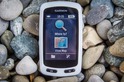
In the lead-up to Eurobike, today Garmin announced the new Edge Explore. Now, you’ve probably heard the Edge Explore or ‘Touring’ names battered around for half a decade or so. Usually along with a numerical identifier like ‘Edge Explore 1000’, which was essentially a dumbed-down version of the Edge 1000. Previously, it’s been targeted at the cycle touring market, but I think the new non-numerically identified unit does away with that.
Nope, now it’s all about mass market and at a price that actually makes sense – $249.
The Edge Explore (kinda a simplified version of the high-end Edge 1030) includes all the core stuff most cyclists want, like full turn by turn navigation on a color touchscreen display that actually works, smartphone notifications, data field customization, and even Connect IQ apps.
What doesn’t it include though? Mostly features that are designed at more competitive athletes. For example, no Strava Live Segments (but you can do Strava Routes and upload to Strava), as well as no structured workouts or advanced training load metrics…or power meter support. But that’s kinda it. Almost everything else it has, save a few minor nuanced type things I’ll dive into below.
I’ve been riding a media loaner unit for about a month now, and overall I’m pretty impressed by it. It works well in my experience, and especially so this morning as I rode across the countryside near the border of the Netherlands and Germany, using it as a rough guide for my 50KM ride (keeping me pointed in the right way, but letting me wander a bit and re-routing as needed).
In any event, let’s get into all the details. I will say this first though, this unit really surprised me.
The Details:
While the Edge Explore may look like an Edge 1030, it’s not quite an identical sibling. Obviously, there are differences in software, but there’s actually some differences in size. The Edge Explore is a bit shorter (about 1cm), which also means the display is a bit shorter too than the larger Edge 1030 display. And the width is a tiny bit smaller too, though that’s barely noticeable.
However, compared to the Edge 520/520 Plus/820, it’s definitely larger. Which, is frankly what much of this target market wants (often slightly more ‘experienced’ adults that may have slightly less adolescent vision).
But it’s really all about the software here. The Edge Explore lineup started off in the touring realm, primarily aimed at the bike touring markets in Europe. Unfortunately, accountants at Garmin apparently did the pricing on it, as it just never made sense. It was often $400-$500, and usually only cost $50 less than the higher end units. Thus, nobody bought it. The non-descript Snow White color scheme didn’t help either (just as it doesn’t now). But ultimately it was dead on arrival with the price point.
Not now though. At $249 it’s incredibly competitive for this market. Sure, it lacks power meters, but for the vast majority of the market that actually doesn’t matter (as much as me and my 5 concurrent power meters would like to think otherwise). There’s nothing on the market anywhere near this price point with full color touchscreen of this size and complete turn by turn mapping.
In any case, first, let’s talk about what’s in there:
– Turn by turn navigation, including re-routing on the fly
– Color touchscreen at 240x400px (and it actually works…see my test lower on)
– 16GB of internal storage with pre-loaded detailed maps for region you bought it in
– Ability to search nearby points of interests (food/etc…)
– Ability to import/download/create routes (from files or Garmin Connect)
– Ability to create round-trip routes based on only a total distance requirement (i.e. give me a 25mi route)
– Smartphone notifications
– Incident detection (for notifying your spouse you managed to crash your bike…again)
– Group Track (to show live on map where other riders are that you’ve friended)
– Fully customizable data fields and data pages (up to 2 fully custom pages + non-custom pages)
– ANT+/Bluetooth Smart sensor support for heart rate/speed/cadence/VIRB/bike lights and more
– Full Connect IQ support for ‘Apps’ and ‘Data Fields’
– ‘Guest mode’ for tour companies to give units to people and not have them screw the settings up
Of course, there’s also a bunch of features that aren’t there compared to an Edge 1030. It’s gonna be tough to list every little bit of nuanced ones, but here’s the key ones:
– No Strava Live Segments support (but you can upload to Strava and use Strava Routes App)
– No Power meter support (or power meter metrics like TSS/NP/IF)
– No structured workout support (meaning, download structured workouts like intervals to the unit)
– No advanced FirstBeat driven training load or related metrics (including FTP or VO2Max)
– No activity profiles (differing profiles for different ride types like mountain biking vs road riding)
– No WiFi sync (probably doesn’t matter much)
– More limited custom data pages (you can only have 2 custom pages, but they are fully customizable)
– No Varia display (and thus, no extended display mode for certain watches)
– No barometric altimeter (GPS based, plus post-upload altimeter correction)
Got all that? Good.
Of course, for some people these individual items may very well matter. For others…it might just be a shrug. Totally depends on your specific needs.
Now to wrap all these features up and walk you through the user interface and features step by step of the Edge Explore I put together this video, including some snippets from a ride this morning on it:
Still looking for more info? No worries, keep on reading then!
The Basics:
Ok, so let’s walk through the user interface a bit, as well as some tidbits from my ride today. First up we’ve got the home screen, as seen above. This is what you get when you turn it on. While it looks very similar to that of the Edge 1030, you’ll notice it lacks a ‘Training’ menu option. It’s that menu option that normally houses things like structured training and ANT+ trainer control. Additionally, you lack the ability to select a specific activity profile.
Instead, you’ve got a more simplistic UI. The main option up top (‘Ride’) takes you straight into the ride screen, ready to start…well…riding. It automatically turns on GPS and gets things going. You can turn off GPS if you’re indoors of course. At this point in time it doesn’t have the option to select GLONASS or Galileo or any other GPS configuration other than on.
What you see above is one of the two main custom pages. These pages can be customized with up to 10 data fields per page, and all the variants you’d expect (like lap distance, total ascent, heart rate % max, max speed, etc…). Probably 35-50 data fields…without typing them all out here. So you get two of these pages for whatever you want.
But you also get a handful of other pages that are ‘stock’. These include the map page, elevation page, compass page, and the GroupTrack page – if you have a friend (aka ‘Connection’) within range. Otherwise that page disappears. The compass and elevation pages can have the two lower data fields fully customized. Here’s a look at a few of those (elevation is blank on this photo since I was standing in a field and hadn’t moved yet):
To start the ride it’s just like other Garmin units where you use the buttons at the bottom for stop/start, as well a dedicated button for lap control.
Meanwhile, you can swipe down from the top for access to quick controls like sensors, GPS status, lighting, and smartphone notifications.
Speaking of sensors, the unit supports the following types of sensors:
(Note: That it doesn’t actually appear to support Bluetooth Smart sensors when I try it, but perhaps that’s just a beta device oddity [Update: It is a beta quirk, Garmin says it should be working but isn’t for me at the moment.]. Meanwhile, ANT+ Sensor types not included on the Edge Explore are power meters, gear shifting, and Edge remote.)
Here’s a look at the sensor pairing and new sensor menu:
All of this data is then recorded to the file, and in turn to Garmin Connect. From there it uploads to the various platforms that you’ve added partnerships to, like Strava or TrainingPeaks. Here’s a look at an activity that I did uploaded to Garmin Connect (link here), connected to a Wahoo TICKR-X and a Scosche 24 ANT+ cadence sensor.
When it comes to lights, you can control light sets as well, all of which worked pretty well for me lately actually – including for non-Garmin lights. Super simple.
As for the touchscreen itself, it’s super responsive – especially in maps. Check out the first video up above, about 3-4 minutes into it, where I zoom around the maps. It’s almost cell-phone fast. Finally! And routing/re-routing? Given that’s all I did today (as I explain in a moment), it was super quick. Far faster than the Edge 520 Plus or Edge 820 that’s more expensive, and on par with the Edge 1030 (way more expensive). But what about water on the display? Well…I just leave you with this hilarious video I put together on the drive down. The first rain we’ve had in weeks:
But let’s talk mapping. After all, if you’re buying this unit over just about anything else…it’s because you want maps. Likely even pretty maps. So all of the navigation pieces are divided into essentially two groups: ‘Where to?’ and ‘Courses’ (both on the homepage).
Starting first with courses, these are for predefined or circular routes. For example, courses you created on Garmin Connect (website), Garmin Connect Mobile (phone app), or via dragging a file over. Additionally, this is where you can create round-trip routes or multipoint routes. Round-trip routes are routes you specify a desired duration (and potential direction of travel), and it’ll spit back three options for the route – based on bicycle paths. Whereas the ‘course creator’ routes are when you add multiple stops, one after another. That’s ideal for touring where you have a smattering of points you want to visit throughout the day.
Meanwhile, in the case of saved/transferred routes, you can pull up details like a map overview, distance, and elevation profile.
But what’s most interesting is the ability to specify an address of a location (like a street address), or search for a point of interest – such as food or monuments. For that you’ll use the ‘Where To?’ option on the home page.
This allows you to specify the category if you go that route, or anything else as a point to point route. It’ll then leverage cycling-specific data between those two points. Garmin includes the detailed map sets for the region you bought the device in. North America includes North America routes, Europe includes Europe routes, and so on. They do NOT however include global detailed routes.
To expand that a bit, the loaner unit they sent me was a US-based unit, which was great when I was in the US last month. But it’s totally useless from a mapping standpoint now that I’m in the Netherlands (this morning) and Germany (this second). In Garmin’s eyes to solve that you’d go off and buy some expensive maps from them. Thankfully I don’t share that vision, and even more so thankfully you can download free maps. So I downloaded the same free map set from OSM (only takes about a minute), and then I’ve got almost the same data.
I say ‘almost’ because one unique feature Garmin has is that they bake in what they call ‘Trendline Popularity’ data into their map sets (technically it’s baked atop it). That data is essentially cycling heatmap data from the tens of millions (if not hundreds of millions) of activities uploaded each year to Garmin Connect. So it’s a bit better than raw bike route/path data because it shows where people are actually going, and how they favor one route over another. So you don’t get that if you download the free data for outside your region.
Still, the free data was great, and it worked just fine for us today.
And that gets into a little bit on how I used this device this morning in particular. While on previous rides I’ve loaded courses onto it as well as done just free-style riding, this morning I used the ‘Where to?’ functionality as a bit of a rough compass. We picked out a town about 20KM away roughly down-river, and then set out riding towards it. But we didn’t want to follow the most direct route it gave us, instead, we wanted to meander along a river and through farmland.
But that worked perfect for us actually. See, I just let it re-route as it saw fit, and sometimes we followed it, and sometimes it ‘followed’ us. Meaning, it was probably swearing at us a few times as we ignored it yet again. But then we’d come back to it and let it navigate us out of sticky spots before we ignored it again. In many ways it’s exactly how most people do bike touring in Europe – a rough guideline of where to go between two points, enjoying the scenery along the way.
We did almost the same thing on the way back, this time selecting to route us back to the start (an empty field alongside the river), and it worked perfectly. Here’s that ride:
The part where there’s that little loop near the river/railroad? Uhh..that’s where we thought we knew better than the Edge. It told us repeatedly not to take that off-road route. Probably should have listened to it that time.
So what about accuracy of GPS data and elevation data? Like most bike computers on-road these days, I’m seeing virtually no variance of either. The reality of the bike computer industry is that for on-road riding…shrug. Seriously, shrug. I haven’t done a review in the last 2-3 years for bike computers on-road where I could find anything GPS-wise other than complaining about a few meters offset here and there.
For example, here’s a ride showing four different GPS units (no speed sensors or anything on these, just straight GPS). It’s almost as if you only see one…that’s how close they are:
And zoomed in to a bit of an intersection:
You can view the whole file here on the DCR Analyzer. I will note that elevation on that file shows the Edge Explore a wee bit flexy, but that was also two weeks ago on earlier beta firmware.
Elevation data can get a bit messier, but even that – it’s super-rare to have on-road issues and if I look at more recent files, things are definitely much cleaner. But given I live in the Netherlands, the variance is only a few meters, so I’m really looking for wonkiness outliers more than anything. Now…off-road, that’s a whole different ballgame when it comes to both. Unfortunately, I’m lacking mountains living in the Netherlands now, and with that…a mountain bike.
Oh, and finally, let’s briefly chat about Guest Mode. It’s kinda interesting. The idea behind guest mode is mainly for bike touring companies to equip their customers with a bike computer. Within guest mode it locks down some settings (with an optional PIN too), and then allows the guest to track their own stats.
So each of these settings seen below is then tracked uniquely for the guest, and doesn’t impact the ‘owner’. So that includes the history (which doesn’t then show the owners history), as well as brightness levels, tones, personal records, and color modes
It’s a cool concept that makes a ton of sense for this particular product category. It’s also ideal because you can pre-load routes as well on the devices, so if a company is doing the same routes over and over, they can get everything prepared on the device, and when they give the device to a new user each outing, it’s like it’s fresh again. The option to reset everything the guest did is given when you disable guest mode before going back to regular mode. You can’t give the guest a name or anything (such as your friend or partner). So think of it more like a disposable account than anything else.
Device Comparison:
I’ve added the Edge Explore into the product comparison database. This allows you to match it up against various other products that I’ve reviewed, including bike computers and watches alike.
For the purpose of the below, I’ve compared it against the Edge 520 Plus, Edge 1030, and Wahoo BOLT. Like most comparisons, it’s not a perfect match-up, but it does help illustrate the differences. Also, my comparison database doesn’t necessarily do a great job at highlighting the minor nuances around mapping and turn by turn navigation, especially in relation to the BOLT (which can’t re-route mid-ride, only point you in the compass direction of where you should be going). Still, the rest is more clear.
Again, don’t forget you can make your own comparison charts here within the product comparison tool against other units out there.
Wrap-up:
I’m impressed with the Edge Explore. Though, I’m actually most impressed not with the technology, but with the fact that someone at Garmin finally got the message: The previous Explore/Touring lineups were just grossly overpriced. This unit however…it’s beautifully priced for the target market. There’s simply nothing else on the market like it in terms of functionality (primarily complete turn by turn navigation) or display quality (color, touchscreen) anywhere near this price point. The closest would be the Hammerhead Karoo at $399 – which is considerably more than this. If you go with a smaller display, then you’ve got the new Garmin Edge 520 Plus at $279 – but that’s quite a bit smaller display than this and has slower routing/navigation, so that might not work for some folks (of course, it has vastly more features).
Of course, there will be those like myself who use power meters. This unit won’t appeal to you (or directly to me). Same goes if you care about Strava Live Segments. Or the handful of other features that some people may use and others don’t care about. If it wasn’t for power meter support, I could probably use this unit as-is. I did today, just recording the power data on the side with another unit. At this point if Garmin added power meter support it’d cut off interest for the massively high price of the Edge 1030, and realistically, that device isn’t viable for many touring cyclists and those people, like my Dad, who don’t have a power meter (the majority of the market).
So, while there’s nothing in this device we haven’t seen before technologically, sometimes that’s not the point. It’s about hitting the right features at the right price point, and this unit finally seems to nail it. Personally, I would have called it something different – merely to reduce confusion with all the previous variants. But whatever works I suppose. For folks that don’t need Strava Live Segments or power meters, this is easily the best deal on the market today for a color mapping navigational bike computer.
With that – thanks for reading!
Found This Post Useful? Support The Site!
Hopefully you found this review useful. At the end of the day, I’m an athlete just like you looking for the most detail possible on a new purchase – so my review is written from the standpoint of how I used the device. The reviews generally take a lot of hours to put together, so it’s a fair bit of work (and labor of love). As you probably noticed by looking below, I also take time to answer all the questions posted in the comments – and there’s quite a bit of detail in there as well.
If you're shopping for the Garmin Edge Explore or any other accessory items, please consider using the affiliate links below! As an Amazon Associate I earn from qualifying purchases. It doesn’t cost you anything extra, but your purchases help support this website a lot. Even more, if you shop with TPC (The Pro's Closet), you'll save $40 on purchases over $200 with coupon code DCRAIN40! The Pro's Closet has been a long-time partner of the site here - including sponsoring videos like my cargo bike race, as well as just being an awesome Colorado-based company full of good humans. Check them out with the links below and the DCRAIN40 coupon!
And finally, here’s a handy list of accessories that work well with this unit (and some that I showed in the review). Given the unit pairs with ANT+ & Bluetooth Smart sensors, you can use just about anything though.
This is a dual ANT+/Bluetooth Smart cycling cadence sensor that you strap to your crank arm, but also does dual Bluetooth Smart, so you can pair it both to Zwift and another Bluetooth Smart app at once if you want.
This is one of the top straps I use daily for accuracy comparisons (the others being the Polar H9/H10). It's dual ANT+/Bluetooth Smart, and in fact dual-Bluetooth Smart too, in case you need multiple connectons.
Seriously, this will change your life. $9 for a two-pack of these puck Garmin chargers that stay put and stay connected. One for the office, one for your bedside, another for your bag, and one for your dog's house. Just in case.
This speed sensor is unique in that it can record offline (sans-watch), making it perfect for a commuter bike quietly recording your rides. But it's also a standard ANT+/BLE sensor that pairs to your device. It's become my go-to speed sensor.
This wifi-connected scale will track your weight and related metrics both on the scale display and in Garmin Connect (plus 3rd party apps like TrainingPeaks). It'll also then sync your weight to your watch/bike computer, to ensure accurate calorie data.
The HRM-PRO Plus is Garmin's top-end chest strap. It transmits dual ANT+/Bluetooth Smart, but also transmits Running Dynamics & Running Pace/Distance metrics, stores HR data during a swim, and can be used without a watch for other sports. Also, it can transmit XC Skiing Dynamics as well.
And of course – you can always sign-up to be a DCR Supporter! That gets you an ad-free DCR, access to the DCR Quarantine Corner video series packed with behind the scenes tidbits...and it also makes you awesome. And being awesome is what it’s all about!
Thanks for reading! And as always, feel free to post comments or questions in the comments section below, I’ll be happy to try and answer them as quickly as possible. And lastly, if you felt this review was useful – I always appreciate feedback in the comments below. Thanks!
I swim, bike and run. Then, I come here and write about my adventures. It’s as simple as that. Most of the time. If you’re new around these parts, here’s the long version of my story.
You'll support the site, and get ad-free DCR! Plus, you'll be more awesome. Click above for all the details. Oh, and you can sign-up for the newsletter here!
Here’s how to save!
Wanna save some cash and support the site? These companies help support the site! With Backcountry.com or Competitive Cyclist with either the coupon code DCRAINMAKER for first time users saving 15% on applicable products.
You can also pick-up tons of gear at REI via these links, which is a long-time supporter as well:
With TPC (The Pro's Closet), you'll save $40 on purchases over $200 with coupon code DCRAIN40 for tech and non-tech purchases!
Alternatively, for everything else on the planet, simply buy your goods from Amazon via the link below and I get a tiny bit back as an Amazon Associate. No cost to you, easy as pie!
You can use the above link for any Amazon country and it (should) automatically redirect to your local Amazon site.
Want to compare the features of each product, down to the nitty-gritty? No problem, the product comparison data is constantly updated with new products and new features added to old products!
Wanna create comparison chart graphs just like I do for GPS, heart rate, power meters and more? No problem, here's the platform I use - you can too!
Think my written reviews are deep? You should check out my videos. I take things to a whole new level of interactive depth!
Smart Trainers Buyers Guide: Looking at a smart trainer this winter? I cover all the units to buy (and avoid) for indoor training. The good, the bad, and the ugly.
Check out
my weekly podcast - with DesFit, which is packed with both gadget and non-gadget goodness!
Get all your awesome DC Rainmaker gear here!
FAQ’s
I have built an extensive list of my most frequently asked questions. Below are the most popular.
You probably stumbled upon here looking for a review of a sports gadget. If you’re trying to decide which unit to buy – check out my in-depth reviews section. Some reviews are over 60 pages long when printed out, with hundreds of photos! I aim to leave no stone unturned.
I travel a fair bit, both for work and for fun. Here’s a bunch of random trip reports and daily trip-logs that I’ve put together and posted. I’ve sorted it all by world geography, in an attempt to make it easy to figure out where I’ve been.
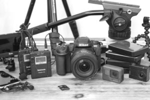
The most common question I receive outside of the “what’s the best GPS watch for me” variant, are photography-esq based. So in efforts to combat the amount of emails I need to sort through on a daily basis, I’ve complied this “My Photography Gear” post for your curious minds! It’s a nice break from the day to day sports-tech talk, and I hope you get something out of it!
Many readers stumble into my website in search of information on the latest and greatest sports tech products. But at the end of the day, you might just be wondering “What does Ray use when not testing new products?”. So here is the most up to date list of products I like and fit the bill for me and my training needs best! DC Rainmaker 2023 swim, bike, run, and general gear list. But wait, are you a female and feel like these things might not apply to you? If that’s the case (but certainly not saying my choices aren’t good for women), and you just want to see a different gear junkies “picks”, check out The Girl’s Gear Guide too.