What exactly is the Edge 800 you ask? Well, it’s a new bike computer that aims to provide all of the cycling features you’d expect from the Edge series (ANT+ support, power meter compatibility and configuration, GPS route recording and workout capabilities), and combine it with features from not only the higher end Edge 705, but also from many of Garmin’s outdoor line of products that allow you to include satellite imagery – known as Birdseye Satellite imagery and custom maps, which we’ll get into in a bit.
In effect, this is combing the best of both words – the smaller form factor closer to the Edge 500, but with a higher resolution screen and far more features than the last generation Edge 705 – all with the fill-in features like a touch-screen from the outdoor/hiking units…finally, in a price about half-way in between.
Like all my reviews, they tend to be pretty in depth (perhaps overly so) – but that’s just my trademark DC Rainmaker way of doing things. Think of them more like reference guides than quick and easy summaries. I try and cover every conceivable thing you might do with the device and then poke at it a bit more. My goal is to leave no stone unturned – both the good and the bad.
Because I want to be transparent about my reviews, as I mentioned when I first got the device – Garmin sent me this Edge 800 for a period of 45 days as a trial unit. Once that period has elapsed, I send the whole messed up box back to the folks in Kansas. Simple as that. Sorta like hiking in wilderness trails – leave only footprints. If you find my review useful, you can use any of the Amazon links from this page to help support future reviews.
Lastly, at the end of the day keep in mind I’m just like any other regular athlete out there. I write these reviews because I’m inherently a curious person with a technology background, and thus I try and be as complete as I can. But, if I’ve missed something or if you spot something that doesn’t quite jive – just let me know and I’ll be happy to get it all sorted out. Also, because the technology world constantly changes, I try and go back and update these reviews as new features and functionality are added – or if bugs are fixed.
So – with that intro, let’s get into things.
Unboxing:
When it first arrives in your hands, it’ll look a lot like this:
After opening it up, you’ll find a box packed with little plastic baggies:
Take those baggies out, and you’ve moved from a large pile of baggies, to a flat surface of baggies:
After removing enough plastic to make a small blimp, here’s the goods:
I’ve gone through and labeled all the different components that came in the box:
Of course, the real center piece is the Edge 800 itself:
Size Comparison and Weights:
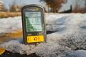
The first question cyclists always ask is: How much does it weigh? Followed closely by…how big is it? So, let’s start with size. I put it in a typical Altoids tin for comparison. If you can’t find an Altoids tin around your pad…I suggest a trip to 7-11. They have Slurpee’s anyway…
Next up, comparison against the popular Edge 500, and the Edge 705:
And last but not least, the weight test. I start with the Edge 500, then do the Edge 800 and then the oldest and heaviest of the bunch – the Edge 705. All figures are in ounces: The Edge 500 is 2.05, the Edge 800 is 3.45 and the Edge 705 is 3.85.
You can see weight-wise it slots in between the Edge 500 and Edge 705 – despite being smaller/lighter than the Edge 705, the screen is actually the same size.
You may be wondering exactly how much 3.45 ounces is. Well, it’s about the same as two medium sized eggs:
All in all, it’s pretty small and fairly light. And in my case, I generally reason that if the extra weight is a big deal – I’m pretty sure I could just forgo a few cookies and lose it off of my posterior instead.
Getting it on the bike:
The Edge 800 uses the newer quarter turn mount system that was introduced with the Edge 500 (well, technically it started with the quick release kit on the Garmin 310XT). This mount system snaps in place using industrial strength rubber bands, and then the unit simply attaches in via a quick quarter turn mount.
This is a huge improvement over the older Edge 705’s mount system…which was a bit of a PITA to say the least. The older system was susceptible to breakage and especially for mountain bikers – popping off. I’ve been using the new quarter-turn mount system for about 9 months now and absolutely love it. It’s super easy to remove the device, yet, the device is highly unlikely to leave your bike. I’m relatively certain if you got hit by a semi-truck, the only thing left still in one piece would be the mount/device to your handlebar.
But…the real kicker is that these mounts are cheap – $9 for a box of two of them, a million rubber bands. Though, everything below is included inbox with the Edge 800 itself – two full sets.
This makes it easy to swap between bikes. I bought a few boxes of them and put them on all my bikes, and my two turtles.
Here’s a quick video on how it snaps in place:
Garmin Edge 800 mount and bike swapping
Note that I’ve tried it on both a triathlon bike and a standard road bike. On the tri bike I find it fits best up on the aerobars:
And on a road bike, your standard bar placement works pretty well:
(You’ll notice I have the 310XT quick release mount to the side zip tied, that’s also compatible with the Edge 800)
One question that’s often asked is: “Can I use it for running?”. The answer is: Sorta. The Edge 800 will record the GPS information just fine, along with heart rate. However, it’ll show your speed in MPH (or KPH) and not in the standard Minutes/Mile pace format. Also, it’s not quite designed for your wrist, but if you pickup the cheap 310XT quick release kit, it’ll snap into that just fine.
Base Cycling Features:
Once you get it all situated on the bike, you may want to pair it to any of your existing ANT+ sensors you have – such as a speed/cadence sensor or a 3rd party power meter. This only takes a second via the menu system:
Once those are set, it’s time to get rolling. By default the Edge 800 will utilize GPS to determine speed, distance and other location information. The Edge 800 uses the same GPS chip as the Edge 500 that came out just later year. In my experience with the Edge 500, the GPS has no issues tracking in virtually all conditions…from trails to airplane flights. In my testing with the Edge 800 – the resultant is the same – no issues in tracking.
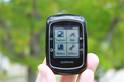
Below is a page I setup with the information I typically use on a given ride:
And here’s another screen with less information displayed – only three fields (click to expand):
Once you’re riding, you’ll have a number of data fields that can be displayed at any one point in time. You can set up to 10 data fields per data screen (up from eight), and have up to 3 primary data screens, in addition to map and course based screens. You can customize all of these screens and data fields however you’d like with the following information:
(Note: These are transcribed directly from the menu’s, expand to actually be readable)
Customizing only takes a second via the menu system. If you’re interested in what data fields I use, here’s my post on how I setup my Edge for different scenarios from racing to training. You’ll notice the screen is super clear, whether in sun or shade:
And by switching to the larger display fields, you can see it from quite far away:
The Edge 800 supports Auto Pause, which is great for city riding. Auto Pause automatically starts and stops the timer once you bike speed has reached a given (customizable) threshold. This is useful if you have a lot of stop lights along the way and get tired of pressing stop/start each time you hit a light.
Note however that it’s generally recommend you turn Auto Pause off if you’re using a Power Meter and analyzing some power-specific workout information such as Normalized Power, where introducing unaccounted for gaps in time can twist your results and artificially inflate them. Just the way the calculations work.
Like the Edge 500, the Edge 800 also supports a movement warning system that lets you know you haven’t hit start yet, but are moving. This is especially useful if you don’t use Auto Pause and instead rely on the old noggin to remember to press start after that bio break.
The Edge 800 includes a barometric altimeter in it. This is standard issue for the Edge line, but isn’t found on the triathlon/running line (Forerunner’s). Barometric altimeters generally improve elevation accuracy over typical GPS altimeters as they use changes in air pressure versus GPS using a fairly complex triangulation method that’s prone to errors. The Edge 800 also lets you customize known elevation data points to allow you to calibrate off that data point. If you’d like a good look at barometric vs GPS altimeters in sport devices, check out this post I wrote up.
The Edge 800 includes a temperature sensor that will display and record temperature along the course of your ride. While I’m still trying to find a good training reason to have a thermometer, I do like the fact that they’ve continued to include it within the Edge series.
Virtual Partner:
Virtual Partner is a cool feature introduced back a few years ago that allows you to race against yourself. Basically you set a given speed you want to maintain, and then the Garmin device will show a little person representing that speed. It’ll also show your progress. If you’re faster than the ‘little man’, it’ll show that. And if you’re slower, it’ll show that. It also shows how far ahead/behind you are.
To setup Virtual Partner, you’ll choose a given speed you’d like to maintain – once done, the Virtual Partner screen will appear. Below is the configuration screen:
In the Edge 800 though – the user interface gets a significant upgrade which makes it look much much cleaner – complete with nifty animated graphics:
Workouts/Intervals:
Once you’ve got the basics of the Edge 800 down, you may start to look at planning downloadable workouts. I often use this feature actually for races more than training. It helps me to execute on a given race strategy.
You can create workouts using both Garmin Training Center or via the user interface on the device itself.
Once created, you’ll navigate through the Edge 800’s menu system into the workout area, to start the workout:
(Because the unit I have is pre-production, there are a few tiny bugs to be worked out still, like the above HR’s lacking the ‘1’ in front of them, as they should be in the hundreds.)
Once you’ve started the workout, the parameters you’ve specified will be shown on the screen. Should you stray from the programmed parameters, the unit will beep at you. The beeping is loud enough that others may believe you’re physically/emotionally harming the unit…so there’s no doubt that you’ll miss the alarms.
Training Indoors:
The Edge 800 supports the ability to train indoors on a trainer, assuming you use the Speed/Cadence sensor and/or Heart Rate Strap. Any ANT+ speed/cadence sensor will work, though for the purpose of this test, I’m using the standard issue GSC-10 from Garmin. I’ve manually set the wheel size, but you can also have the unit auto-configure it by doing a quick ride outdoors where it uses GPS to calibrate the size of the wheel.
When on the bike indoors it’s best to turn the GPS off. While most modern training applications (including all of Garmin’s) easily notice that it should read sensor data over GPS data, some apps don’t. This means when you go to load your workout, it shows you went a grand total of nowhere…instead of showing you actual mileage that the wheel recorded. Once you’ve done that – simply go to town and knock out your workout.
Once done, you’ll see the same speed/cadence/HR/power data that you would outdoors, all on Garmin Connect.
Touch Screen:
If you’ve read my reviews in the past, you’ll know that I’m generally not keen on touch screens in sports devices. The reasoning being that in most cases, a combination of sweat and fingers never results in ones desired menu options. Further more, adding in winter accessories like gloves often makes life even more difficult.
So I was a bit apprehensive when I found out that the unit uses a touch screen. However, one of the first things you’ll notice is it still retains two key buttons for Stop/Start and Lap/Reset – in addition to a power button. In my mind, this is a fair compromise. The two buttons I generally use are these two, and I rarely need to change menu’s very much while riding.
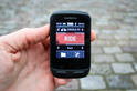
Nonetheless – how well does the touch screen handle? Well, let’s play around with the user interface a bit going through some of the menu’s:
Garmin Edge 800 Touch Screen Video Clip
As you can see from the short video, the unit is surprisingly responsive and seems to pickup my choices pretty quickly (and correctly). It’s also fairly easy to use while riding, especially just scrolling through the data screens with a single tap or swipe.
The unit features a screen lock, should you want to lock the touch screen itself. That’s activated via the top left side button:
Of course, a logical question is how does the screen perform if you put on a pair of winter gloves? Well, I set to find out. I started with the thinnest pair, and then moved up through the most common cycling gloves to some heavy duty sub-zero style gloves, I then finished it off with a pair of mittens. Here’s the ever-so-exciting video…try to hold back your excitement while you watch three riveting minutes of glove action – enough to make OJ nervous:
Edge 800 Touch Screen Glove Tests
As you can see, I was able to fairly easily manipulate the menu’s of the device, including both common tasks and those you might need to do quickly – like change display or bike settings. While there was an occasional ‘typo’, most of those were due to the fact I was trying to watch the lens as the same time.
In short…no problems with gloves.
Mapping via Birdseye Satellite Imagery:
Perhaps the coolest single feature of the Edge 800 is the ability to download Birdseye Satellite Imagery onto it. Birdseye Imagery is basically the same stuff as you’d get if you went to Google Maps or Bing Maps. Essentially, the ability to see your house.
The imagery is based on a subscription service, and the price is $29 a year. This isn’t too bad in my opinion, especially if you use it a lot. To load the imagery, you’ll utilize a piece of software called Base Camp. Users of Garmin’s outdoor line of handhelds will be familiar with this software, but for the rest of us runners/cyclists/triathletes – this will be a new piece of software to add to the lineup.
Base Camp allows you to do route planning – focused heavily on off-road routes like hiking trails or mountain bike trails. But it also has the capability to add in satellite imagery from Garmin’s Birdseye service.
To add imagery, you simply drill down into the area of interest and then choose to send it to the device. Note, you can’t send the ‘entire world’, as its rather big and won’t fit on a single micro-SD card, but you can select pretty big chunks that you’d ride.
From there you simply right click the imagery in the left pane and send it to the device. I would show you the final resultant, but unfortunately the pre-production device I have isn’t quite in the position to show it off for today’s post – look for a follow-up post on that.
As noted above, the imagery doesn’t come on the unit itself from the store, but you can add it to your unit for $29 a year. The only caveat I’ve found is that you can only download so much imagery at a time, and while in the past handheld devices designed for hiking limited how far you could realistically travel – with a bike – you go a lot further. I tried to capture a 30-mile section of Skyline Drive in Shenandoah National Park and the program had a set download limit of about 105MB, smaller than my area of selection. For this to be a truly useful feature for cyclists, I need to be able to select an area covering hundreds of miles – even if that means it takes a bit of time to download, and a bigger MicroSD card (or more than one).
Mapping via City and Topo Maps:
In addition to the cool Birdseye Satellite Imagery, you can still use standard issue maps and topographical maps that you can purchase from Garmin. The more expensive of the two Garmin Edge 800 bundles comes with North America City Navigator. This is important, because the base imagery that Garmin would otherwise provide isn’t terribly useful and doesn’t have many of the streets that you’d likely cycle on. For me, it pretty much only had Interstate 95, whereas the City Navigator maps had everything including the alley in my back yard.
You have two options when you by City Navigator – one is to buy the DVD and the other is to buy the SD card. I was sent the SD card, but I also have the DVD version from when I originally bought the Edge 705. Both work just fine, though the MicroSD card is certainly quicker.
In the case of the MicroSD card (far easier), you simply slide it in the back slot. It comes with a regular SD card adapter though if you want to update/add to it on your computer.
Once in the slot the Edge 800 will automatically recognize it and show off the more detailed maps. Check the below before (left) and after (right):
(Before)
(After)
You can purchase Garmin detailed maps for just about everywhere on the planet, and, with a bit of creativity you can also create your own maps.
Garmin Custom Maps:
In addition to utilizing downloadable/purchasable maps, you can also create your own maps and upload them to the Edge 800 via Garmin Custom Maps. This is particularly useful if you have maps that contain additional data not found via common providers. For example, you may have a map that lists all port-o-john’s in your area (any cyclist/runner knows this is important). However, for my example I simply grabbed the city’s local bike maps and went to town. Here’s the initial city provided map I started from:
While I won’t detail the process fully as it’s well described here, here’s what the half-way mark looks like:
As I get it all aligned, you can see my city bike map overlayed on the detailed city map. As you can imagine, this would be incredibly powerful if you have heavily customized maps with waypoints or unique features not normally found on traditional online maps. For example, water stops, bathrooms, etc.. are all common on race routes, and would be perfect for overlaying into the device.
And finally, once I’ve loaded it onto my actual device and navigating with it:
(At this juncture you may be wondering how I got that clear screenshot…well, the Edge 800 includes the ability to simply tap the power button and take .bmp screenshots)
Pretty cool stuff and really gives you (and even event planners) a ton of flexibility.
Navigation:
The Edge 800 has the same navigational features that you’d expect from a car GPS. For example, it’ll give you turn by turn directions and show you how far until the next turn:
And you can also go into the menu’s and select POI’s (Points of Interest) – such as food or if you’re feeling tired after that long ride…a hotel. Or you can simply enter in any street address. It’s astoundingly quick within the UI, and has auto-complete so that you don’t need to type in the full street addresses or states.
And if you get off course, it’ll re-calculate you’re route for you in seconds automatically:
I’ve put together a short clip showing what it looks like if you’re riding and it’s routing. You’ll have to excuse some of the focus/bumpiness issues. I was riding while holding a full DSLR camera in one hand and trying to navigate a time trial bike with the other…while dodging squirrels, cars and small kids. Sometimes sketchiness happens.
I start off the clip showing destination address entry, and then from there we’ll get into the actual riding:
Garmin Edge 800 On Street On Bike Routing
Yes…I survived the creation of that video – I was pretty happy about that.
Power Meters:
The Edge 800 supports all ANT+ power meters, which includes ones such as the PowerTap Wireless, Quarq Cinqo and SRM power meters. There are a few more power meters coming in September as well with Interbike that support ANT+.
I use the Quarq Cinqo as my power meter (and love it), which is shown below:
The Edge 800 has a number of power configuration options on par with the Edge 500 and 705. This includes the ability to set zero averaging for both cadence and power.
In addition, you can display a number of power-related fields, including all of the following:
Power
Power
%FTP
Power
30s Avg.
Power
3s Avg.
Power
Avg.
Power
kJ
Power
Lap
Power
Max
Power
Watts/kG
Power Zone
The recording rate when a power meter is attached is every second, or 1s as it’s commonly written.
The above is an XML snippet showing the 1s recording while a power meter is attached. Without a power meter attached it defaults to ‘smart recording’, which on this device is averaging a data point between every 1-4 seconds, which appears to be a bit of an improvement from other devices.
ANT+ Scale Support:
The Edge 800 is the first Edge series device to support ANT+ scales. Past Edge devices haven’t, only the Forerunner 310XT and Forerunner 60 have supported the ANT+ scales that are out on the market. These scales wirelessly communicate your weight and body fat information to the Garmin device, which in turn gets uploaded to Garmin Connect. Today’s most common ANT+ scale is the Tanita BC-1000 – which I reviewed back in the winter.
To scan for scales, you simply go into the menu system and select Weight Scale. From there, it’ll initiate the ANT+ search.
Once it finds the scale, the green scale light will illuminate and you can go ahead and step on it. The scale will take your weight, and then communicate it back to the Edge 800.
The Edge 800 will then upload that data to Garmin Connect, where you can track your weight related information over time.
Software:
I typically get into the software a bit more in my In Depth Reviews of products, but I’ll cover the basics here on the first look review. The Edge 800 connects using a USB cable and shows up like any other mass storage device:
Once connected, you can go ahead and launch Garmin’s free online site – Garmin Connect – to analyze your ride data. The site will allow you to upload directly from the unit. The unit itself can record a crap-ton of data. On my Edge 500 (similar storage size) I have almost a year’s worth of rides on there and I’m only a few percent full. So no worries about running out of space.
After the upload has completed – and it only takes a few seconds – your activities are shown by date in both a calendar, list and dashboard view. You can select them to get more detailed information about that activity.
On the left side you’ll see summary information, while on the right you have graphs for each of the major sensor and data types:
Garmin Connect is a good option for beginner to intermediate users looking to analyze their data. However, for more advanced users I’d recommend a program like WKO+,Sport Tracks, or Training Peaks. The Edge 800 utilizes the newer Garmin .FIT file format, and all three of those applications (latest versions) support the .FIT file format. Personally, I use both Sport Tracks and Training Peaks daily. Training Peaks easily uploads the files using their free Device Agent (or just via the web uploader).
I prefer Training Peaks because of some of the power meter analysis you can do, as well as some of the longer range trending that’s easier/possible to do than on Garmin Connect. TP has both a free and premium version.
It should be noted that the Edge 800 is also supported via the old school Garmin Training Center (free) – should you want a basic desktop application. But, Garmin really isn’t updating this app much any more and is only used for some basic functions.
Also note that if you plan to utilize imagery from Birdseye, remember that you’ll need Basecamp – which is also free from Garmin.
Finally, all this stuff works great on a Mac as well, if you’re of that persuasion:
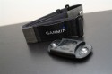
Accessories:
The Edge 800 supports all of the major ANT+ accessories out there. This means you can utilize any existing Speed/Cadence/HR/Power Meter sensors you have without having to by any new ones. Plus, any of the non-Garmin ANT+ sensors that are coming out on the market (or already there) are also supported.
This sensor allows you to use the Edge 800 indoors on a trainer, as well as records cadence information outdoors. Additionally, you can increase your accuracy a hair if you use the speed sensor outdoors (automatically occurs actually).
Depending on which version you pickup, the unit will either come with the Premium ANT+ Heart Rate Soft Strap, or it’ll require you to pick on up. You can utilize any existing ANT+ strap (such as one from an older Garmin unit), but it does have to be ANT+. Meaning, a strap from a Polar or similar unit won’t work.
Garmin today itself offers two straps – one is the classic strap, and the other is the newer ‘Premium Soft Strap’. However, an even newer premium strap has also been tossed into the mix. This one looks very much like the Polar Wearlink Strap and is oddly enough ‘licensed’ from an unnamed organization. Garmin had no comment on who it was licensed from.
Note that the Edge 800 bundle includes the newer premium soft strap HR monitor, which is different than the older soft strap one. This new strap may resolve some of the issues of the existing soft strap, but more testing is in order – it will be available as a standalone strap ‘later this year’. I just wrote up a good post earlier this week on a workaround for the older one, as well as a much longer post on other tricks to try.
Power Meters-
The Edge 800 will pair easily with any ANT+ power meter. I have the Quarq Cinqo and it recorded data from it without issue. PowerTap, SRM, and Quarq all make ANT+ compatible power meters. And there are a few others coming on the market here in the coming weeks leading up to Interbike. See the previous section on more details on power meter configuration options.
As noted earlier, you can pickup a box of extra mounts for about $9. This box includes two full sets of mounts, and a million extra rubber bands. By far, the cheapest cycling product you’ll probably ever buy.
Maps, maps and more maps:
Because the Edge 800 supports both topographical and city imagery, as well as satellite imagery, there’s a ton of different mapping products you can buy for it. You can also create your own maps using some 3rd party tools. In my limited time with the product I haven’t had a chance to dig into compatibility quite yet, but I’ll do so for my final in depth review. In the meantime, here’s the basic different maps offered:
In summary, this device rocks. It’s everything that most cyclist have been asking for – even if they didn’t know they were asking for it. I love the new mapping capabilities as it bridges the gap from hard to decipher street maps, to crystal clear satellite imagery. The ability to create custom maps is really really cool, and I’m looking forward to folks whipping up some relevant maps for cyclists and longer races. Plus – and perhaps most importantly – my fiancée has immediately decided she wants one…now.
However, I do question the ability for the Garmin Edge series to compete long term with cell phones. Over the last 12 months the number of cell phone based applications that effectively do large portions of what the Edge 800 does has grown. While the Edge 800 adds functionality around custom maps and offline caching of large satellite image tile sets that is difficult to find on phones today, it is an area that competitors will rapidly catch up on. I was hoping that the next generation Edge device would include some sort of connectivity to allow updates to Internet based infrastructure – such as Live position tracking – helping it to compete with phones that also have ANT+ integration.
That said – for a purely dedicated cycling computer, there’s nothing like it today. And that includes the phone world. There is no phone/app combo I’m aware of that does all of the features that the Edge 800 does from complex mapping and navigation to ANT+ data integration.
The Garmin Edge 800 will be available in mid-October with the following pricing:
– Black/White Edge 800 is $449.99 (with AC adapter, quarter-turn Mount, USB cable)
– Black/Blue Edge 800 Performance and Navigation bundle is $649.99 (Adds newer Premium Soft-strap Heart Rate Monitor, Speed/Cadence sensor and City Navigator Maps on MicroSD)
If you’re looking at some of the other Edge series line, I’ve put together this quick comparison chart. When comparing between the Edge 705 and the Edge 800 – I see no reason to purchase the Edge 705 at this point, and as such, I’ve updated my 2010 GPS recommendations to instead focus on the Edge 800 over the Edge 705. If you comparing between the Edge 500 and the Edge 800 – they serve two different markets with one focusing on slim and sleek and the other focusing on navigation.
No review would be complete without the Pro’s and Con’s list – so here I present the time honored tradition:
Pro’s:
– Easy to use and small form factor
– Compatible with all major online/offline training applications
– Supports ANT+ accessories
– Improved virtual partner feature
– Use of satellite maps
– Creation of custom maps
– Very quick touch screen UI
– You can take screenshots by holding the power key
– You can change the background to both custom and pre-set images
Con’s:
– Wireless data transfer to other units removed
– Unclear on touch screen long term use with gloves in winter
– Not ‘connected’ to the Internet, no options for live data updating (like cell phone)
– Unable to get large satellite map sets onto device due to download limiters set
So with that – start saving your pennies!
Found this review useful? Here’s how you can help support future reviews with just a single click! Read on…
Hopefully you found this review useful. At the end of the day, I’m an athlete just like you looking for the most detail possible on a new purchase – so my review is written from the standpoint of how I used the device. The reviews generally take a lot of hours to put together, so it’s a fair bit of work (and labor of love). As you probably noticed by looking below, I also take time to answer all the questions posted in the comments – and there’s quite a bit of detail in there as well.
I’ve partnered with Clever Training to offer all DC Rainmaker readers an exclusive 10% discount across the board on all products (except clearance items). You can pickup the Garmin Edge 800 in any of the available colors below. Then receive 10% off of everything in your cart by adding code DCR10BTF at checkout. By doing so, you not only support the site (and all the work I do here) – but you also get a sweet discount. And, since this item is more than $75, you get free US shipping as well.
Additionally, you can also use Amazon to purchase the unit or accessories (though, no discount on either from Amazon). Or, anything else you pickup on Amazon helps support the site as well (socks, laundry detergent, cowbells). If you’re outside the US, I’ve got links to all of the major individual country Amazon stores on the sidebar towards the top. Though, Clever Training also ships most places too and you get the 10% discount.
Thanks for reading! And as always, feel free to post comments or questions in the comments section below, I’ll be happy to try and answer them as quickly as possible. And lastly, if you felt this review was useful – I always appreciate feedback in the comments below. Thanks!
As you’ve seen throughout the review there are numerous compatible accessories for the unit. I’ve consolidated them all into the below chart, with additional information (full posts) available on some of the accessories to the far right. Also, everything here is verified by me – so if it’s on the list, you’ll know it’ll work. And as you can see, I mix and match accessories based on compatibility – so if a compatible accessory is available at a lower price below, you can grab that instead.
Finally, I’ve written up a ton of helpful guides around using most of the major fitness devices, which you may find useful in getting started with the devices. These guides are all listed on this page here.
I swim, bike and run. Then, I come here and write about my adventures. It’s as simple as that. Most of the time. If you’re new around these parts, here’s the long version of my story.
You'll support the site, and get ad-free DCR! Plus, you'll be more awesome. Click above for all the details. Oh, and you can sign-up for the newsletter here!
Here’s how to save!
Wanna save some cash and support the site? These companies help support the site! With Backcountry.com or Competitive Cyclist with either the coupon code DCRAINMAKER for first time users saving 15% on applicable products.
You can also pick-up tons of gear at REI via these links, which is a long-time supporter as well:
With TPC (The Pro's Closet), you'll save $40 on purchases over $200 with coupon code DCRAIN40 for tech and non-tech purchases!
Alternatively, for everything else on the planet, simply buy your goods from Amazon via the link below and I get a tiny bit back as an Amazon Associate. No cost to you, easy as pie!
You can use the above link for any Amazon country and it (should) automatically redirect to your local Amazon site.
Want to compare the features of each product, down to the nitty-gritty? No problem, the product comparison data is constantly updated with new products and new features added to old products!
Wanna create comparison chart graphs just like I do for GPS, heart rate, power meters and more? No problem, here's the platform I use - you can too!
Think my written reviews are deep? You should check out my videos. I take things to a whole new level of interactive depth!
Smart Trainers Buyers Guide: Looking at a smart trainer this winter? I cover all the units to buy (and avoid) for indoor training. The good, the bad, and the ugly.
Check out
my weekly podcast - with DesFit, which is packed with both gadget and non-gadget goodness!
Get all your awesome DC Rainmaker gear here!
FAQ’s
I have built an extensive list of my most frequently asked questions. Below are the most popular.
You probably stumbled upon here looking for a review of a sports gadget. If you’re trying to decide which unit to buy – check out my in-depth reviews section. Some reviews are over 60 pages long when printed out, with hundreds of photos! I aim to leave no stone unturned.
I travel a fair bit, both for work and for fun. Here’s a bunch of random trip reports and daily trip-logs that I’ve put together and posted. I’ve sorted it all by world geography, in an attempt to make it easy to figure out where I’ve been.
The most common question I receive outside of the “what’s the best GPS watch for me” variant, are photography-esq based. So in efforts to combat the amount of emails I need to sort through on a daily basis, I’ve complied this “My Photography Gear” post for your curious minds! It’s a nice break from the day to day sports-tech talk, and I hope you get something out of it!
Many readers stumble into my website in search of information on the latest and greatest sports tech products. But at the end of the day, you might just be wondering “What does Ray use when not testing new products?”. So here is the most up to date list of products I like and fit the bill for me and my training needs best! DC Rainmaker 2023 swim, bike, run, and general gear list. But wait, are you a female and feel like these things might not apply to you? If that’s the case (but certainly not saying my choices aren’t good for women), and you just want to see a different gear junkies “picks”, check out The Girl’s Gear Guide too.


![IMG_9887[4]](https://media.dcrainmaker.com/images/2010/08/garmin-edge-800-in-depth-first-look-review-36.jpg "IMG_9887[4]")


![IMG_9658[4]](https://media.dcrainmaker.com/images/2010/08/garmin-edge-800-in-depth-first-look-review-46.jpg "IMG_9658[4]")


![IMG_9599[4]](https://media.dcrainmaker.com/images/2010/08/garmin-edge-800-in-depth-first-look-review-76.jpg "IMG_9599[4]")


![CustomMapsOverlay[3]](https://media.dcrainmaker.com/images/2010/08/garmin-edge-800-in-depth-first-look-review-103.jpg "CustomMapsOverlay[3]")


![CadenceAvg[3]](https://media.dcrainmaker.com/images/2010/08/garmin-edge-800-in-depth-first-look-review-118.jpg "CadenceAvg[3]")
![Pwravg[3]](https://media.dcrainmaker.com/images/2010/08/garmin-edge-800-in-depth-first-look-review-120.jpg "Pwravg[3]")