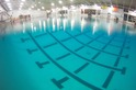
Last week following the Nation’s Triathlon, I stumbled on some pictures on Flickr from the event. There was a huge assortment of pics taken on that day – ones of athletes during each of the sports, a few artistic ones, some general group shots and then a few of the river. It was one river shot in particular that caught my attention. This shot (below) clearly showed the massive differences in lines that people took as part of the course.

So I contacted the photographer (Jim Tavenner) and asked if I could use it as the center of a post. He graciously said no problemo (go check out the rest of his photos from that day!)
See, the photo is interesting for a number of reasons. First, it shows the huge differences between the lines people took. Second, it was taken from an elevated position (the bridge), which makes it really easy to see the whole section of the course. Third, you can clearly see the number of folks who are struggling a bit (looking at their stroke/position/treading water). Finally, it was taken later in the the swim (8:22AM), which means that the majority of folks pictured here are likely from earlier waves and are swimming a bit longer than faster swimmers.
That said – let’s start with the official course map as a reference point:

Remember how I wore a Garmin 310XT in the swim? Well, it recorded a pretty darn clean track – see below. As you can see the exact real course was a bit different than the above (in both placement and quantity of buoys). For example, I’m relatively certain there were only two total buoys north of the bridge.
 So I started thinking – what if I combined the earlier photo – with a known track used on race day? Well, first, let’s start with something easier – let’s take my Garmin track, and run it through Google Earth, and then change the point of view to match the photo.
This below is looking downriver, including the bridge. As you can see, the GPS signal drops out when I go below the bridge, which is fine. But what I want you to notice of, is the pillars – as that starts to dictate some of the course line that folks will take. In particular, the right pillar (which is when we start heading downstream).
 Now, let’s zoom in a bit, to mimic the photo. I kept the land portions in-frame so things are a bit easier to understand.

Now after a lot of aligning, re-aligning, more aligning, and a crapton more aligning, here’s the two images merged together. My photo-shop skillz are limited, so the line is a bit faded, but still very visible:

While it’s not ‘perfect’, it’s about as close as I can get after an hour of toying with it. So, what does this show us…aside from my line? Well, for that we need to bring a really big tape measure into play here to understand some distances. The cool thing about Google Earth is it includes a ruler to be able to determine how long something is by simply dragging.

I took the ruler and then spread it across the width of the ‘screen’ – or essentially the photo (yellow line). 56 yards, roughly. I say roughly because I don’t have the precise elevation/lat/long to be able to exactly align the photos. But to me, 50 yards passes the reasonable test looking at the people in the river. Probably a bit more than that – but we’ll use that as a ‘minimum’.
So…let’s talk about what that means. See the folks to the right of the yellow line?

They likely all swam about an extra 50 yards round trip. And the folks to the right of the red line? About an extra 100 yards roundtrip. And that’s just on the downriver leg – without taking into account the other 2/3rds of the course. Now, they do save a bit of distance as long as they swim a triangle pattern (remember A^2 + B^2 = C^2?).
So how much extra time does that equal? I’d guess at least a few minutes for most folks, not including time spent swimming over/under others (as you can see – plenty of others), and then sighting, etc.. You can see a number of the folks off to the right treading water or looking around trying to figure out where to go next.
Now, that’s not to say my line was perfect – in fact far from it. You can clearly see where I did a wee bit of wandering – especially if you notice my lack of ideal line on the upriver leg earlier on in the satellite photos. But one thing you’ll notice is that I don’t actually hit up those first two buoys in the above photo – this is because from a line perspective, it just wasn’t the most efficient line. This is primarily because of the support columns for the bridge, and simply the placement of the turn buoys upstream.
Anyway, when I saw the photo I figured I’d be a perfect opportunity to dive into how much time can be saved simply by swimming the most efficient line. Which…reminds me – the same concept applies to running – where I did a similar breakdown of how running courses are measured. Lastly, thanks again to Jim Tavenner for allowing me to use his photo. Have a good one everyone!
FOUND THIS POST USEFUL? SUPPORT THE SITE!
Hopefully, you found this post useful. The website is really a labor of love, so please consider becoming a DC RAINMAKER Supporter. This gets you an ad-free experience, and access to our (mostly) bi-monthly behind-the-scenes video series of “Shed Talkin’”.
Support DCRainMaker - Shop on Amazon
Otherwise, perhaps consider using the below link if shopping on Amazon. As an Amazon Associate, I earn from qualifying purchases. It doesn’t cost you anything extra, but your purchases help support this website a lot. It could simply be buying toilet paper, or this pizza oven we use and love.


Very impressive and detailed mapping job of how we can save time and effort on the swim. WOW you have a lot of time on your hands now that your IM race is over. Heheheh!
Wow, nice analysis! Sometimes the extra distance is worth it if you take less pummeling in the swim. It is interesting just how much extra distance you can cover by going a bit wider.
Your blog is broken in my google reader. It thinks your last post was on the 310XT review.
Very interesting analysis, Ray. I noticed that A LOT of people started, and continued swimming very far to the right on the first 1/2 of the course, whereas a lot fewer stayed closer to the buoys. What do you think of the role water-current possibly played in this decision, compared to the extra distance they traveled by staying closer to land?
Wow. Math, Physics, and Topography overload! I would totally be one of those people on the outside… I like my space… even if it means swimming an extra 100 yards.
I think the current probably played a part in it. During some time-trial tests the day prior, I found I went downstream about 20% faster than upstream with the same effort. Therefor, folks were essentially getting in trouble 20% faster than going the other way.
On the upstream side, I think people stayed closer to the bank because they forgot (or purposefully didn’t place) any buoys on the upward leg, so it was basically a wild-shot to the bridge where you really couldn’t see where the actual turn buoy was until you got under the bridge, hence my pretty big turn at that point.
LOL I am guessing the Girl is out of town!
Think of all the GPS fun you could have if you started running trails!
Nice piece of analysis. Pretty easy to see where some folks misjudged their swim.
This is amazing. It’s like CSI:Potomac. I love it when you use all your geek skills in a public service capacity. Well done, again.
Love it! I’m a take the shortest line even if it means you get pummelled…the extra boost from the draft, especially in bigger races is totally worth getting hit, kicked and otherwise violated!
Really cool post!
that is seriously impressive work. I don’t see the kayak i was hanging onto though. oh right, at 8:20 my wave had NOT YET GONE OFF YET.
Is there some buoy shortage I don’t know about? Would it kill them to put a few more out there? For my $160 I demand buoys!
Thanks for reminding me of math class!
Great article. I read a book called “Open Water Swimming” by Penny Lee Dean a great many years ago and it gave me a great boost on my open water technique. It is funny how many people start the race a the “wrong side” of the race start, when all the anchored boats are showing you which way the current will pull you.
You can also increase your speed by not looking up more than necessary. Instead you can look at the general direction of atletes swimming beside you and calculate your relative position with that. Also, if it is a sunny day, you can use the angle the light enters the water to know the line you are making in the swim. That also works when the current has different temperatures, as you can feel the cold in the side of your body…consider the direction of the tide and where you intend to go.
Anyway, there is little reason to loose speed looking up more often then necessary.
I loved this post, but I worry that I’m one of the ones pictured WAY out of line.
I went with the “wide berth” school of thought, because I was recovering from a HORRIBLE Baker’s Cyst behind one knee, and was otherwise injured.
It was also my first(!) Tri in a wetsuit, and I was looking forward to not hyperventilating or panicking like I had done for at least one other Tri that was too warm for a suit. So I started off right in the pack, and got kicked in the head A LOT, so I basically let myself drift “right,” in order to just swim my own race (I had no intention of doing anything other than finishing in 1 piece).
Anyway, this is a great post, and absolute reaffirmation that I need to just suck it up (and maybe wear my bike helmet in the water). 😉
@dcrainmakerblog Re this post link to bit.ly I had a HORRIBLE swim line @ Nation’s, but did it injured. Was trying to avoid getting kicked in face!
I just read your excellent article. One factor that you are missing in your equation is that the current speed in a river is not constant. As a rule of thumb the speed is faster where the river is deeper and closer to the middle and slower where the river is shallow and closer to the shore. If you had a current profile of the Potomac you are probably going to find that folks in right were in a faster current section. This an example of a current profile: link to pubs.usgs.gov
Ray,
in fast flowing rivers it sometimes makes sense to swim closer to the river banks upstream because of the eddy, where the current leads you upstream. Lesser currents on slower moving rivers may also play a role.
Now, I don’t know the strength of the current in the Potomac.
Greetz from a kayaker…
Uli
This race will be my first Olympic and with only two sprints under my belt, I am just a little nervous. I have been waking up at night imagining what the current and eddies in the Potomac are like and now, I guess Pythagoreans Theorem will be costing me sleep too. Only 18 days left….
Thanks!
Love what you do!
Awesome, good luck! You’ll enjoy it. Don’t worry too much about the eddies or current (well, unless it pours). Good luck!