Ever since booking our honeymoon months ago I was curious exactly what the GPS map would look like while running outside on the circular running track while the ship was underway at sea. Would you be able to see the circular pattern at all once you mapped it onto a satellite view? And what exactly would the distances and speeds look like?
Well, I set out to find out.
During our 10-day cruise I ran a handful of times on the ship while a sea. In most cases I simply ran indoors on the treadmill because the pool deck was crazy crowded with civilians that were busy munching down hot dogs while aimlessly wandering around and moving beach chairs onto the running track. Thus, running during normal hours wasn’t really an option.
But running indoors wasn’t entirely without entertainment. See, once the boat starts to rockin a bit the treadmills became quite interesting. This is because the treadmills faced the ocean and were fairly close to the edge, which meant if you rocked the boat to port/starboard (left/right) it felt like you were instantly going uphill or downhill.

For fun, I’d sometimes leave the GPS portion on while running on the treadmill (or on the stationary bike), just to see later on where we’d gone while I was running or biking:

The cool thing here is that I can actually set it to see the real treadmill running speed vs the GPS boat speed…but I’ll talk about that in a minute.
First, let’s head outside.
The cruise ship had a track that looped around one of the upper decks overlooking the pool area and was about a tenth of a mile long. During the day this was prime sunbathing grounds, but in the very early mornings it would be clear. Additionally, if you managed to hit the timing just right it was empty in the evenings in between the sun starting to set and the first dinner seating, but before the evening outdoor dance/party activities would kick up. Here’s the track:


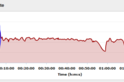
First, I’ll note our actual speed over the water. I simply put it in cycling mode for a moment to take this picture – it’s the bottom number, 23.5MPH:

Next I switched over the FR610 to running mode. Then I did something important – I switched the Speed Source in the footpod settings to be from the footpod and not from the GPS. If I had just set it for indoor mode it wouldn’t have recorded the GPS track or my location.

Why’d I do this? Well now instead of showing me the GPS speed on the watch, it’ll show me the speed that I’m actually running by using the ANT+ footpod I had on my shoe (see this post for everything you ever wanted to know about the footpod). Now you can see as I’m running along the top data field shows my actual pace over the deck of the boat (6:55/mile), versus my pace over the water (23MPH!).

So off we went running. We tied off our bags to some chairs and went about doing a LOT of laps.

Honestly, I can’t quite remember how many laps, but I suspect it was about 30 laps in total. I’m not sure I could do many more laps, it was almost getting dizzying how quickly you’d complete each circuit around the pool:

But, it did provide for some fantastic views as we got to watch sunset from from virtually every angle:

Of course, there’s still the outstanding question: How’d the GPS piece look? Well first let’s check it out from on high:

From that high up it doesn’t look too much different. For the most part it just looks like I ran 10 miles in a straight line on the ocean. But let’s go ahead and zoom in a bit…or rather, a lot:

From here you can just barely start to see the weeble-wobble back and forth in the GPS track as I crossed each side of the pool deck. But let’s zoom in a tiny bit more:

Yup, you can now very clearly see when I ran across the deck to the other side. And it roughly matches the scale compared to the width of the boat.
While this would be much cooler if you could actually see the boat overlaid in the picture – you’ll just have to imagine it for now. I’m sure someday satellite technology will be able to show it all in real time playing back images from whenever you’d like. Regrettably, today is not that day on Google Maps.
What’s that I hear? You want me to draw it in instead? You mean you want a comeback of some of my past MSPAINT skillz (click the link and scroll a bunch if you weren’t here two years ago)?
Ask, and you shall receive!

Ok, not my finest PAINT hour. My specialty isn’t naval vessels.
But you know what the best part is though? While the speed/pace shown on the screen uses the footpod, the distance displayed actually uses the GPS. Thus the following:

Yup, the way I see it I just set a new 10-mile PR at 26 minutes and 12 seconds. I think they should just give me the Olympic Gold Medal now, no need to wait another year till London 2012.
FOUND THIS POST USEFUL? SUPPORT THE SITE!
Hopefully, you found this post useful. The website is really a labor of love, so please consider becoming a DC RAINMAKER Supporter. This gets you an ad-free experience, and access to our (mostly) bi-monthly behind-the-scenes video series of “Shed Talkin’”.
Support DCRainMaker - Shop on Amazon
Otherwise, perhaps consider using the below link if shopping on Amazon. As an Amazon Associate, I earn from qualifying purchases. It doesn’t cost you anything extra, but your purchases help support this website a lot. It could simply be buying toilet paper, or this pizza oven we use and love.


Great post so interesting maybe one day I’ll be on a boat and boy will I have fun.
was just on holiday and took Mr. Garmin with me to see how high the mountains in Switzerland are…
I did the same thing about a year ago, on a ferry in British Columbia. The ferry was stationary at the dock for the first few laps. At full magnification, you can see the side-to-side motion and the change in the speed and direction of the ferry. At EveryTrail.com, trip 828114 (“Ferry walk”), in case my link doesn’t work.
Ferry walk
You were running counterclockwise?
Yup, counter-clockwise. No particular reason, though it seemed most people who were running were running that direction.
Why does it look like you just ran off the boat instead of looking like you did a bunch of loops? I figured it would look like a big spiral since you were doing circles while the boat was moving ahead. Can someone explain that please? Thanks!! 🙂
They turn GPS Off over water…yep…???go look at flat earth theory ir will all make sense ..unless you’re brainwashed
Ray – with TP or ST, were you able to check the difference between the over-the-water speed when you were running with the travel of the boat and when you were running against?
It would be fun to see the graph of that speed going back and forth between ~30mph and ~16mph
With my FR305, I always turned off the GPS when I ran on deck or on the treadmill when we took a cruise earlier this year. I don’t know whether the FR305 has the same option to choose between showing footpod pace or GPS pace if the GPS is on.
@anonymous – If the boat is traveling at 23mph, and Ray and The Girl (The Wife?) are running on deck, their over-the-waters speed is the the two added together when running towards the front, and the running speed subtracted when running toward the back.
They would have to run faster than 23mph (a world record shattering 2:36/mile) to get it to register as them actually running that way as the ship is cruising along.
At 7mph (8:34/mile) it should register as going back and forth between the 30mph and 16mph I mention above.
Great experiment. I tried running on the treadmill on a cruise a couple of years ago. I had a fail boat moment for sure. The seas were angry that day, like an old man trying to return soup at a deli. Anyway, I ended up getting shot off the back of the treadmill when I tried to wipe my face with a towel. I sported some pretty impressive raspberries on my knees for the rest of the trip.
My immediate guess was that your route would trace a cycloid, like a fixed point on a bicycle tire.
link to en.wikipedia.org
On reflection, you’d have to be running really, really fast to do so. Fascinating post, I love this stuff.
I did something similar a month ago on an Alaska cruise. I left my FR610 on GPS (don’t have a footpod) and was hoping it would pick up the ‘wobble’ also. I only did one mile (4 laps) at an 8:22 pace and ended up with: link to connect.garmin.com.
But is says I covered 2.82 miles in 2:59.
I also did a mile while in port in Skagway. It was an 8:58 mile, but the GPS wasn’t precise enough to get the tight track. This map looks like I was practicing my walking on water: link to connect.garmin.com
JP- thanks!! Perfect explanation. The light bulb went off. It all makes sense now lol
@Steve – did you change to “aeria” view? There was actually a ship in port when they took the sat photos.
REALLY fascinating! Along the same lines (but less scientific), I thought it would be interesting to wear my Garmin while mowing the lawn: link to connect.garmin.com
Hi Ray, I’ve just discovered this post and it reminded me of the garmin track a friend of mine recorded while running the north pole marathon a couple of years back, due to the drift of the ice and the multi-lap (7 I think) course the track showed as a spiral. Sadly I am not about to go and repeat his experience for the sake of your blog though!
Thanks for this post! I’ll be aboard Allure of the Seas in <1 week (2.5 laps per mile!) and was going to bring my Forerunner 305 along since I'm training for a marathon in June. Now I know what to expect (wear the foot pod for serious tracking, use GPS for fun).
Thanks again! Very cool and I absolutely love this stuff (the running too!).
So it makes sense on my next cruise turn off gps and use inaccurate nike plus footpod lol
Hi,
I have question. I am looking for a GPS Wrist Worn on for Cruise Ship. What I am Looking for that Track GPS where I am at. I have been Looking to find Right one before I go on Cruise Ship. Because it my First time to go on Carnival Cruise.
Let me know which one is the Right one. Thank you.
Richard
Can you setup the 620 to do this too? Aka, keep the gps track, but use the footpod for speed\distance?
No, you can’t select it at this point.
Sorry for hijacking an old thread, but do you suspect that the accelerometers of the newer model GPS watches (220/620, etc.) would be accurate enough for tracking running mileage WITHOUT A FOOTPOD while on a cruise ship? Or do you think the motion of the vessel would interfere with the data? Thanks!
It’ll track without a footpod, as it’s no different than a treadmill. The motion of the vessel wouldn’t have any effect there.
The challenge is more foundational in that said accelerometer based pace/distance doesn’t tend to be super accurate. It’s usually good for your mid-range paces. But anything faster/slower tends to be incorrect. But it varies by person, some folks it snaps perfectly onto, and others it’s a complete mess.
Hello Ray and thank you for the informative post.
I have now the same configuration you had at that time. I usually run always with footpos as source of speed. This way I think the current pace is more accurate.
Now my questions are:
1) the average pace displayed for each lap is an info coming from the gps, isn’t it?
2) the “pace” temporal diagram displayed in the garmin connect web-interface is coming from where? GPS or footpod?
3) and what about the info showed in the split section?
Thank you for everything!
Cheers,
Lello.
I am looking to buy the Garmin Forerunner 235 for my daughter, who works on a cruise ship. So it’s a bit of a unique situation in that I’m looking for something accurate that will work for someone who is on a ship all the time and not just for a nice vacation. 🙂 She runs on the treadmill in the ship’s gym, but also uses the track on the upper deck if it’s not too busy. She’s just started to get into running regularly and normally does about 6 miles/day but wants to run a half, so will occasionally go longer. I’m trying to get her something that will be accurate and hopefully help her with her pacing and stuff. I love my 235, but just don’t know how well it will work on a ship. Right now, all she has is a lap clicker–LOL–so anything is an improvement. Just don’t want to drop $300 on something that’s not going to work anyway because of where she is. She’s not going to want to use a footpod or anything, so don’t want to have to add that complication to the mix. Thanks for your input!
Interesting post! My husband and I will be in Ironman training during our Alaskan cruise. I was curious about the Garmin thing. I think I’ll take my Garmin and play around with it some, but likely I’ll just use the treadmill.
FR735XT displays instant pace rounded to 5 sec/km. If I had this foot pod connected and set as speed source, would I get instant pace accuracy of 1 sec/km? Would it display, say, 4:17?
there was a great article! I read it and enjoyed.
Ray,
I’ve been running and biking on Zwift this week on a cruise. Maybe time to update your article since cruise ships feature internet and you can carry your powertap powercal, cadence sensor, and/or footpod. Still, rocking boats make treadmills interesting.